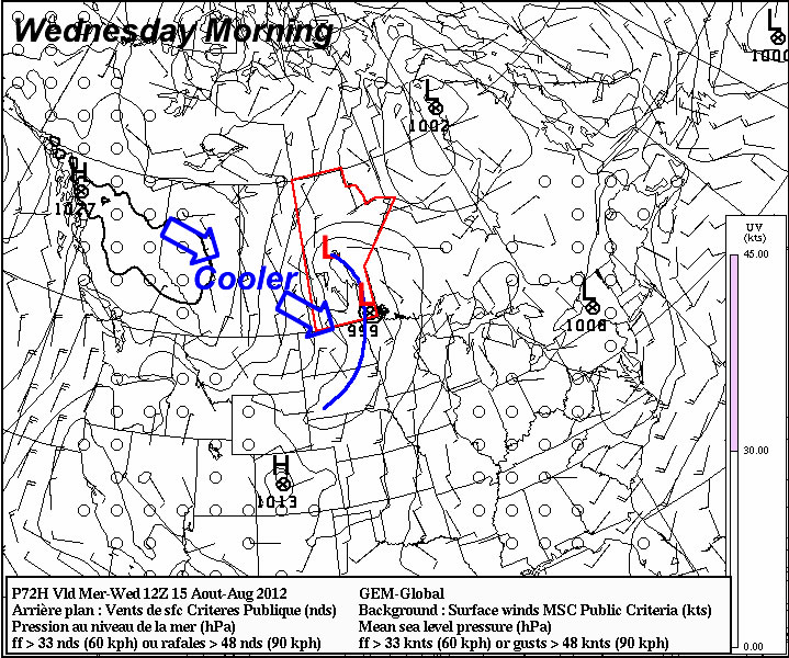
A Chance of Showers Today, Mild Weekend Ahead

A weak trough pushing across SW Manitoba today will push into the Red River Valley this evening, bringing with it some scattered showers or thundershowers. Things will clear out quickly, and we’ll be looking at temperatures in the mid-20’s for the weekend.

GEMREG QPF for Friday Afternoon

Total expected precipitation from teh GEMREG model this afternoon.

We’ll have a slightly more unsettled day today as a weak surface trough pushes into the Red River Valley this afternoon. Temperatures will climb up to just over the 20°C this afternoon before showers and thunderstorms develop over SW Manitoba and push eastwards into the Red River Valley. Dynamics begin to fall apart as the afternoon progresses, and any showers or thunderstorms will struggle to survive in an increasingly disorganized environment. It looks like the best chance of seeing some rain this afternoon will be through the Western Red River Valley, with diminishing chances east of the Red River. By the time the trough gets to the Whiteshell, the threat of precipitation will likely be over.

Saturday looks to be a gorgeous day as sunshine once again dominates across Southern Manitoba and highs climb to around 25°C. Things will turn a little more unsettled overnight on Saturday as an area of rain blossoms over Southern Saskatchewan and heads our way. The exact location of the rain is still uncertain, however best indications are that we’ll see a cloudy day across much of the Red River Valley, with the bulk of the rain passing north of Winnipeg through the interalke region, with only a chance of showers for Winnipeg and areas south. It will certainly be a system to keep an eye on as the weekend progresses.

Cool, Wet Weather For The Weekend

Winnipeggers: get ready for a shock. The next few days are going to be startling chilly with daytime highs over 10°C below normal and overnight lows over 5°C below normal. Another thing that will be noticably absent other than warmth? The sun will make only a few rare appearances over the next several days as another system pushes into Southern Manitoba, bringing another round of rain and thunderstorms to the Red River Valley.

850mb Temperatures valid 00Z Friday

850mb temperatures vaild at 00Z Sat. May 26 (Friday evening). An elongated cold trough is sweeping across Southern Manitoba, bringing 850mb temperatures in the -2 to -5°C range.

This cool weather has brought late-season (or is it early-season now?) snow to several communities over Western Manitoba including The Pas, Flin Flon and higher elevations over SW Manitoba (Duck Mountain & Riding Mountain areas). A few leftover flurries will scoot across the Interlake this morning and exit out of the province. The Red River Valley wil be spared, however we’ll be stuck under low clouds with a daytime high that struggles to make it to 10°C.

Tonight, a widespread frost potential exists over the most of Southern Manitoba. As a surface ridge moves into our area, winds will abate and we’ll see the cloud begin to break up a bit this evening. The greatest potential for frost looks to be over Southwestern Manitoba in the Virden, Melita, Pilot Mound & Brandon regions. Further east, here in the Red River Valley, some scattered clouds and a bit of moisture trapped in the valley should help temperatures stay above freezing, with overnight lows in the 2-3°C range. Areas outside the City of Winnipeg in the RRV certainly have a slight risk of a light frost. Winnipeg will likely be frost-free, with an off-chance of patchy frost in outlying areas near the Perimeter Highway.

Saturday will be our transition day with temperatures reaching 13-14°C and cloud streaming northwards from the Dakotas with the next incoming system. Rain will push up towards the International Border by morning, likely staying in the States but certainly poses the chance of a few showers along the border. The rain will stay near the border until Sunday, when the next big northward push arrives.

24. hour precipitation accumulation Saturday morning to Monday morning](https://img.skitch.com/20120525-mkq1sh9w3aa3twa7r6stuq9j2q.png)

Precipitation accumulation from the GEM-GLB model for Saturday morning to Monday morning. A broad swath of rain is forecast to fall from extreme SW Saskatchewan through Southern Manitoba.

And what a push it will be! Showers and thunderstorms will rapidly develop into an expansive area of rain on Saturday night, slowly pushing northwards across the Red River Valley. Most regions across Southern Manitoba should expect rain to start fairly early on Sunday and last through most of the day. Rain will likely taper off from west to east overnight, with only a few wrap-around showers moving across the RRV on Monday. It’s still early to give accurate estimates of rainfall totals for this next system, however in general, most regions across Southern Mantioba look to see at least 10-20mm of rainfall, with the potential for nearly 30mm in some areas of the RRV if some embedded convection can get going. Regions of Southwestern Manitoba that end up north/northwest of the main upper low track will see higher amounts as well, with 20-30mm of rain likely. This isn’t the best news for this year’s Teddy Bears Picnic, but hopefully shouldn’t dampen spirits too much at an event that has, historically, had to deal with some pretty awful weather. Wait, I’m getting deja vu…

Conditions look to improve through the middle of next week, with temperatures pushing back towards the 20°C mark and some sun finally making an appearance. That’s a ways to go, though, so grab your slippers and heat up some soup! We have some great stay-inside weather coming up. We’ll be sure to keep a close eye on this system and provide updates in the comments.

Nice Today, Then Showers & Rain

Winnipeg and the Red River Valley will get a bit of a reprieve from the unsettled weather of late today with some sunshine and daytime highs in the mid-teens for Winnipeg and closer to 20°C for regions in the Southern Red River Valley. Conditions will deteriorate tonight, however, as Southern Manitoba deals with another low pressure system that will move through on Thursday.

12hr. QPF -- GEMREG

12 hour precipitation accumulation from the GEMREG model. Valid 12Z Thursday to 00Z Friday.

Clouds and showers will push into the Red River Valley tonight as a low pressure system makes it’s way through North Dakota. A very slight risk for a thundershower exists along the US border, however the odds aren’t very likely. For everyone else, just plain old rain will be pushing your way. Models disagree on how far northwards the precipitation will push: the American models keep the northern edge on a line that cuts from Morden to Bisset, south of Winnipeg, while the Canadian models push the precipitation as far north as Gimli. It seems fairly certain that the southern half of the Red River Valley will see showers tonight and Thursday; Winnipeg will likely see at least a few passing showers out of this next system, with a chance that we’ll see rain tonight through much of tomorrow.

12 Hour QPF -- NAM

12 hour precipitation accumulation from the NAM model. Valid 12Z Thursday to 00Z Friday. Notice how the NAM keeps the precipitation much further south; whereas the GEMREG has Winnipeg in the highest accumulations of the system, the NAM keeps us on the Northern fringe of the rain with very little accumulation.

For areas that do see steady rain, total accumulations should be in the 5-10mm range with localized areas that see some convective enhancement seeing as much as 15-20mm. My current feeling is that Winnipeg will see at least 5-10mm through Thursday evening.

Rainfall in systems like this is typically hard to predict because it is so dependent on the initiation of elevated convection at night; something that models do not have a great handle on and humans struggle with not because we don’t understand it, but because there’s simply so little data to work with. Small errors in the location or strength of initiation of the nocturnal convection can result in huge errors in the model for later times, which can cause the model to end up forecasting tons of rainfall for one location that ends up seeing nothing and completely missing other areas that might see plenty of rain. For this reason, working off of real data is often the best way to go; satellite & RADAR imagery can be a forecaster’s best friend in dealing with nocturnal convection. A drawback to this, though, is that you can’t make your forecast as early. As soon as things begin to take shape, a forecaster can act quickly and make a fairly accurate forecast for the next 12-24 hours. It’s crucial to make sure that the starting point is correct, though, which is why when dealing with convectively driven situations, it’s important to talk in terms of probabilities and likelihoods while still a ways away from the event actually happening.

Saturday Rain Followed By A Warm Up

After a pleasant Friday, Southern Manitoba will see a showery Saturday as one last system pushes through the province before a large-scale shift in the upper atmosphere brings above-normal weather back to our neck of the woods.

500mb Speed Map

500mb Wind Speed map from the NAM depicting the strong jet core associated with a low forecast to track across Southern Mantioba.

For today, the Winnipeg & the Red River Valley will see sunny skies with milder temperatures, courtesy of the cold trough that we’ve been under the influence of the past few days finally moving off towards the east. We should see a daytime high of about 12°C today, which is right around normal for this time of year.

Tonight, clouds will roll in ahead of a system that is sliding across the Prairies. Showers will push into Southwest Manitoba this evening along a NW-SE line aligned with the lift associated with a strong 90kt jet streak at 500mb. This line will push eastwards through the night and enter into the RRV by morning. The showers should weaken and spread out into a band of light rain by the time it reaches Winnipeg. Although the rain won’t be particularly heavy, the system looks to be relatively slow moving, and because of that it seems like most areas in Southern Manitoba will see between 2-5mm of rain. We’ll refine rainfall amounts in the comments a little closer to the event.

The rain clears out on Saturday evening and clouds will scatter overnight. Skies should completely clear by Sunday afternoon through the RRV leaving us with sunshine and a high near 15°C.

For next week, temperatures will remain in the low teens as an upper ridge begins to build into the Southern Prairies, however we’ll have to wait and see how much sun we’ll have. The potential for several powerful systems to track across the Prairies exists; we’ll be sure to keep an eye on whether or not these systems will impact Winnipeg and the Red River Valley!