Elsewhere in Weather News: March 22nd, 2014

Below Normal February Temperatures for most of Continental US; Will Return

What seems to be the winter that won’t give up in Southern Manitoba has not only been persistent in the Canadian Prairies, but also a good chunk of the United States. The central and eastern half of the US has been fairly consistent in staying below normal in February thanks to a persistent trough on the east coast and ridge over the west coast. Consequently, a northwest flow in the upper levels of the atmosphere has established itself over the Northern US Plains and Midwest and, as a result, Arctic highs were continuously helped down into the region. Interestingly enough, central North America has been one of the only regions in the world to experience below normal temperatures in February.

Temperature anomalies across the globe for February, notice the below average in Central/Eastern US, contrasted by the much above normal just to the east, over the ocean. This is caused by persistent troughing on the East Coast. (Source: NOAA)

The pattern, which has not shifted around much this winter, has caused extremes to occur not only temperature-wise but also precipitation wise. The problem is that with the ridge staying put over the area systems have trouble making their way into the region and instead diverted further north. California continues to experience severe to exceptional drought – the highest level of drought, as per the US Drought Monitor. Consequences might not be immediate but could spell trouble once the wildfire season rolls around, and when water reserves literally start to run dry in the state. Currently, about 60% of the state is considered to have an above average risk for wildfires due to the drought, according to NICC.

Sunday night into early next week yet another blast of Arctic air is expected to infiltrate across a good chunk of the United States. In addition to this cold blast, models are showing a potent Nor’easter Tuesday-Wednesday next week blasting through the Northeast US and Atlantic Canada which could drop significant amounts of snow. However, there is a glimmer of hope for the central United States as most models are in agreement that temperatures late next week into next weekend will be either bounce back to normal or slightly above normal.
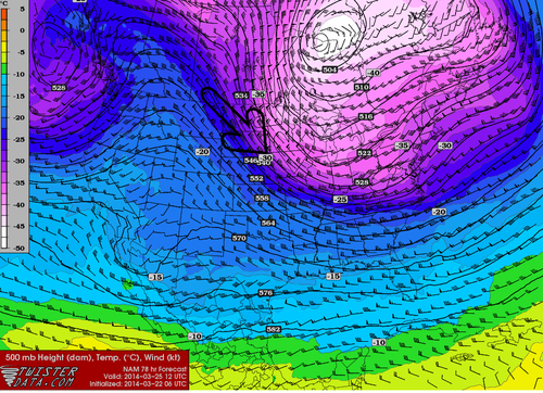
500mb northwest flow returns to the region this week, shown by the NAM here, on Tuesday morning. (Source: Twisterdata)
Northwest flow returns to the region this week, shown by the NAM here, on Tuesday morning. (Source: Twisterdata)

Hot Weather Returns

After a period of cool weather over the last while, warmer conditions are set to return.

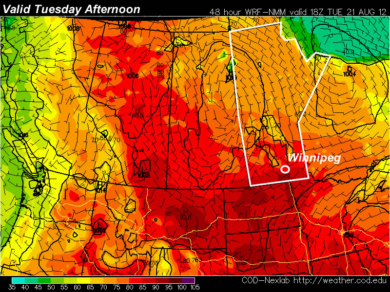
30C temperatures are expected on Tuesday in Southern Manitoba

The NAM model is predicting that Southern Manitoba will see temperatures of 30C or higher on Tuesday

A ridge of high pressure will build over the Prairies this week, allowing for some of the warmest weather we’ve seen this August to develop. Monday will be a pleasant day, with high temperatures in the mid to upper twenties. By Tuesday many areas should see their first 30C readings this month, as warmer air pushes in from the west.

The ridge will begin to break down on Wednesday and Thursday as a series of impulses move in from the Pacific. These impulses with have one or more low pressure systems associated with them, causing some unsettled weather to start developing over the Prairies later this week. It looks like an easterly flow will develop over Southern Manitoba on Wednesday out ahead of an approaching low. Depending on how the frontal features setup on Wednesday we may or may not see another 30C day. At this point it looks most likely that Wednesday will have temperatures in the upper twenties, rather than thirty, but there is the potential for warmer weather. On Thursday we may see our first risk of thunderstorms in a while as a strong southerly flow draws up more humid air from the south ahead of an approaching low pressure system.

As we move toward the weekend weather models show a series of fairly strong low pressure systems moving through our region. Should these systems develop more or less as predicted it would likely mean a rainy and cool last weekend of August.

Surprise! More Hot Weather

This week will be another hot one in Southern Manitoba and indeed all over Western Canada. The potential for thunderstorms during the week may temper the heat somewhat.

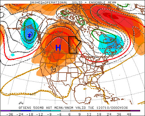
A large ridge of high pressure will reside over Western Canada this week

A large ridge of high pressure will reside over Western Canada this week

The weather forecast for this week will be rather tricky. What we do know for sure is that it will be hot all week, with high temperatures being near 30C every day. However, what is somewhat unclear is the risk of thunderstorms during the week. Let’s start with the easy part – the heat.

Temperatures will start out the week in the upper twenties or near thirty on Monday and Tuesday in Southern Manitoba. Humidity levels should remain low on these day making conditions hot, but not excessively so. By Wednesday high temperatures should be be in the low thirties with the humidity making it feel closer to 40. It currently appears that temperatures for late week will remain around the 30C mark, with humidity levels remaining elevated.

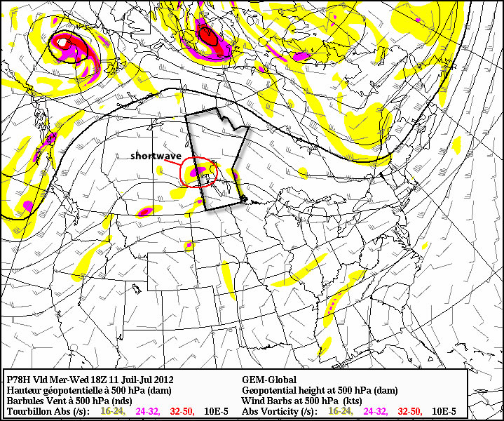
A shortwave will move toward the Eastern Prairies on Wednesday, potentially helping to trigger thunderstorms

A shortwave will move toward the Eastern Prairies on Wednesday, potentially helping to trigger thunderstorms

The presence of heat and humidity over the Prairies this week will cause the atmosphere to become unstable, creating the risk of thunderstorms on many days. Unfortunately, the thunderstorm forecast is not entirely certain. The issue is that a large region of high pressure, such as the one we’ll be under, does not typically promote widespread thunderstorm activity. In fact high pressure usually suppresses convective activity. It looks like this ridge will not be very good at suppressing thunderstorms, which complicates the forecast significantly.

At this point it looks most likely that Southern Manitoba will see thunderstorms mainly during the second half of this week, from Wednesday onward. During that time period the atmosphere will be most unstable and there will be some weather features moving through the region which may trigger storms. The jet stream has weakened significantly over the Prairies as of late, meaning that most storms will be non-severe in nature. Heavy rain will likely still be a concern though due to slow storm motion. Some severe storms will also be possible just simply due to the instability present in the atmosphere. Although stronger storms will certainly be less widespread than weaker ones. As the week progresses we’ll have to reassess the thunderstorm risk one day at a time.

While my forecast for this week might seem a bit equivocal, that will just be the nature of the weather in the short-term. Unfortunately thunderstorms are just simply unpredictable a frustrating but unavoidable aspect of mother nature.

Improving Weather

Southern Manitoba will see improving conditions today and round out the work week with nice conditions and near-normal temperatures.

Ridge Dominating Southern Manitoba

Model 3hr. QPF & MSLP w/Surface analysis valid 00Z Thursday April 19th

There will be a slight chance of some light snow this morning over the western half of the Red River Valley as a weak short wave slumps into North Dakota. As it exits the province, clouds will clear and we’ll be left with a sunny afternoon with a high near 8°C.

Clear skies will be the weather story for the rest of the week as a ridge of high pressure builds in from Northern Saskatchewan. We’ll have an overnight low near -6°C tonight and warm back up to a repeat of today on Thursday, with a high near 7°C. Rinse and repeat for Thursday night. As a system pushes into the NW United States, slightly warmer air pushes into Southern Manitoba and we’ll likely see our daytime high bumped up a few degrees to around 10°C.

Saturday brings with it a chance of rain as an upper trough swings across the Prairies. We’ll keep an eye on that as the week progresses!

In short, it’ll be a sunny, albeit a little cool, rest of the week!