Photo by @aweathermoment — Instagram

Uneventful Weekend Ahead for Winnipeg

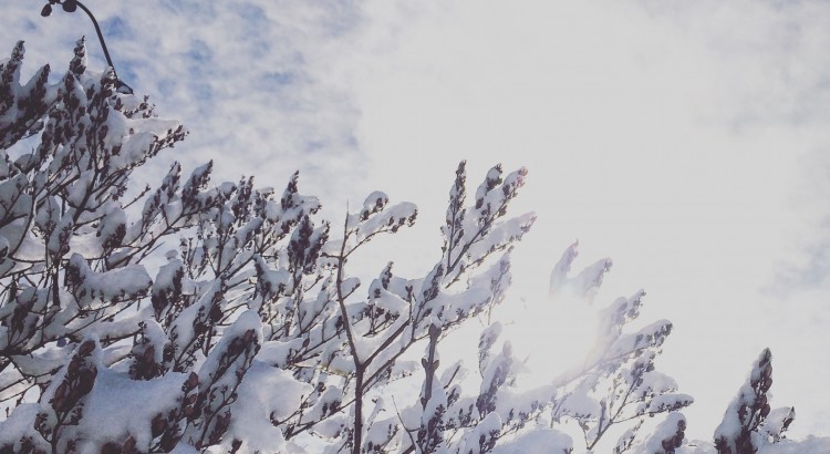
After a stretch of weather that brought record breaking temperatures, record breaking dew points, and new daily rainfall records[1] before shifting into a weird weather pattern that brought moderate-to-heavy snow to much of southern Manitoba (with a rather beautiful aftermath, pictured above), the weather over the coming days will be downright dull as a benign pattern brings seasonal temperatures to Winnipeg.

In a rather nice change of pace, there isn’t too much to talk about regarding this weekend’s weather. Near-seasonal temperatures will be in place throughout the weekend with daytime highs hovering in the 0 to +2°C range while overnight lows hover between -6 to -8°C. Skies will progressively become more cloudy with a sunny day today, a few clouds tomorrow, and mixed skies on Sunday, but no precipitation is expected. Winds will remain quite calm throughout the weekend with the strongest winds on Sunday at just 20km/h or so.

Long Range: More Active Week Ahead

Next week is looking a little more active with a storm system expected to move through on Monday night & Tuesday. It’s too early to try and pin down too many specifics, but overall it appears that it will spread 5-10cm of snow across Southern Manitoba followed by some gusty northerly winds that may produce some local blowing snow.
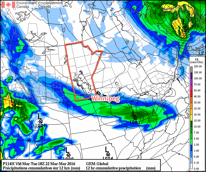
GDPS 12hr QPF forecast valid 18Z March 22, 2016
The GDPS is showing a solution further south than other long-range models, pushing Tuesday’s system southwards into the United States

Towards the end of next weak it also appears that we may see another weak disturbance produce some light snow over the region.

Temperatures will be fairly consistent next week with daytime highs and overnight lows expected to be near-seasonal.

Winnipeg’s seasonal daytime high is currently 0°C while the seasonal overnight low is -10°C.


  1. See our summary post for more details.  ↩
A Short Warm-Up

There will be only a couple days of sun before the threat for rain returns to the Red River Valley.

After a few unsettled days across Southern Manitoba which, depending on where you were, brought anywhere from no rain to upwards of 15-25mm, the weather is set to offer refuge from the gloom in the form of sunshine and perhaps the warmest temperatures we’ve seen all year. Unfortunately, the pleasantries will be cut short when another complicated weather set-up involving a large cut-off upper low and multiple impulses travelling northeastwards out of the United States redevelops.

Friday

Friday
15°C / 5°C
Mainly sunny.

Today will be a pleasant day with mainly sunny skies and winds out of the northwest at around 20km/h. The temperature should reach a high around 15 or 16°C, which will likely be the warmest day in Winnipeg since we hit 15.1°C on April 23rd. Unfortunately, this will still be 2-3°C below our seasonal normal.

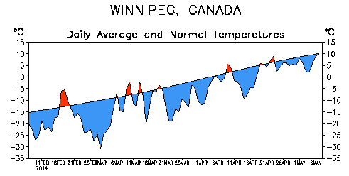
The normal average temperature and departure from it over the last 90 days in Winnipeg.

Despite the temperatures warming up slowly, the fact that we’ve spent such an unbelievable amount of time with temperatures below normal is what is driving many in Winnipeg to dream of warmer climes. Even last year, which had the latest snowpack melt on record[1] had already seen temperatures as high as 26°C by this point.

Unfortunately, I don’t have much good news in that department.

Saturday

Saturday
18°C / 7°C
Increasing cloudiness late in the day.

Saturday will be the nicest day of the year so far, hands down. Skies will be mostly sunny until the cloud shield associated with the next low pressure system begins creeping into the region in afternoon or evening. Winds will be out of the south at around 20-30km/h and the temperature will skyrocket to take the top spot of 2014 so far…at a seasonal 18-19°C![2].

Saturday night will be mainly cloudy with a chance for showers pushing into the southern Red River Valley overnight. The temperature will drop to around 7°C.

Sunday

Sunday
12°C / 3°C
Cloudy. Periods of rain likely.

Sunday will bring a return to cooler, wetter weather as the weather pattern shifts back into a more unsettled regime. It’s a bit early to get too specific, but it seems likely that some light rain is likely as a low pressure system meanders into the Red River Vally from southwestern Manitoba. The high will be close to 12°C and the low will dip down to 2-3°C.


  1. In 2013, the snow pack did not reach a trace amount until April 27th in Winnipeg.  ↩
  2. Crack the champagne!  ↩

Warmer and Unsettled Weekend Ahead

Temperatures will finally push towards seasonal values this weekend as a warmer air mass pushes into Southern Manitoba from the Western Prairies. Daytime highs are set to climb into the mid-single digits which will bring the warmest temperatures since March 14th of this year when we managed to struggle our way to +4.0°C. Tagging alongside the milder temperatures will be unsettled conditions with multiple chances for precipitation through the next few days.

Friday

Friday
0°C / -5°C
Mainly sunny.

Today will be quite a pleasant day with mainly sunny skies and a high near 0°C. A ridge of high pressure will keep the winds light through the day as well. There may be a few cloudy periods this morning as we clean out any remnant cloud from yesterday’s system, but otherwise there should be plenty of sunshine.

Later today will see the approach of a warm front tied to a low pressure system tracking through the northern Prairies. Winds will increase out of the south to around 30km/h tonight as the warm front approaches. Thanks to the wind and some cloud pushing in later in the night, we’ll drop to only around -5°C.

Saturday

Tomorrow has the potential to be a bit of a messy start to the week. The warm front will be pushing it’s way through early in the day, bringing with it the potential for some snow or freezing rain.

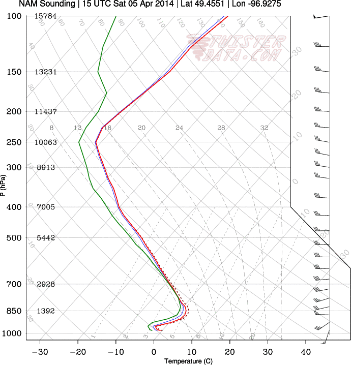
Winnipeg forecast sounding for Saturday morning from the NAM.

This forecast sounding shows the development of a small layer of above-freezing air (AFL) above a below-freezing layer of air at the surface. The AFL doesn’t look very deep, so freezing rain is far from a sure thing as the balance between melting snow and reinforcement of warm air will be a delicate one dependant on how intense the precipitation is.

Saturday
7°C / -5°C
Cloudy with chance of flurries or freezing rain in the morning, then clearing.

Depending on whether or not the precipitation manages to build far enough south to reach the Red River Valley is the primary unknown; if it does reach us then there’s a chance it will fall as freezing rain instead of snow. Whatever it decides to fall out of the sky as, though, it will be fairly short-lived and confined to the morning.

After the warm front pushes through in the morning, skies will begin to clear up and the temperature will begin climbing towards a high of 6 or 7°C. Saturday will be the warmest day in Winnipeg since the temperature hit 10.3°C on November 13th last year. Winds look to be light through the day.

Temperatures will drop to around -5°C once again on Saturday night with light winds.

Sunday

Sunday
3°C / -9°C
Mainly sunny.

Sunday will be a slightly cooler albeit still pleasant day. Winds will be relatively light out of the south as we head to a high temperature of 3°C. An incoming low pressure system will spread cloud into the Red River Valley late in the day and bring a chance of some flurries through the evening and overnight periods.

All in all it will be a fairly pleasant weekend without too much wind and some mild temperatures. Aside from a few brief chances for precipitation, it might actually feel quite spring-like out there! Enjoy!