A Quick Return to Seasonal Conditions; Windy End of Weekend

Today is off to a cold start after a cold front passed through the Red River Valley yesterday morning, ushering in winds up to 70km/h and some mixed-phased showers as the cooler air mass moved into the region. The cool-down will be short-lived, fortunately, as seasonal to above-seasonal temperatures will return for today & through the weekend.

Today and tomorrow’s dominant weather feature will be a ridge of high pressure that will move through the region over the coming two days. With it in place, daytime highs will be cool at a seasonal or slightly below-seasonal 9–10°C. Winds will be light, and both tonight and tomorrow night will see overnight lows dipping below the freezing mark to around –2°C.

GDPS Surface Wind Forecast for 18Z Sunday October 18, 2015
The GDPS surface wind forecast for midday Sunday shows a core of stronger winds as a result of the outflow from the ridge of high pressure to the east.

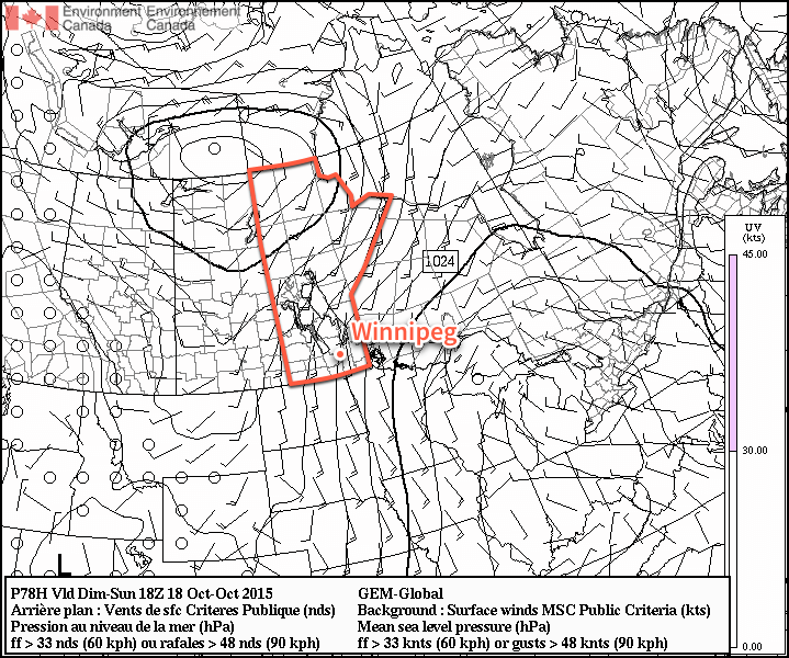
Sunday will see a sunny start to the day, but a bit of cloud push in for the evening and overnight hours. The biggest weather issue of the day will be strong southerly winds that develop as surface winds accelerate out of the ridge of high pressure to our east and are aided by the strong temperature gradient as warmer air moves in aloft.[1] As such, winds will increase–likely midday–to around 40–50km/h out of the south with some gustiness on top of it. It won’t be severe-level winds, but it will certainly be a windy fall day. Temperatures will be slightly warmer at around 14°C, kept lower than the air moving in over us would suggest by the cool outflow winds at the surface.

The winds will taper off in the evening and temperatures will head to around 6°C for an overnight low under partly cloudy skies.

The Week Ahead

Next week is looking fairly unremarkable for the most part. There appears to be a slight chance of some rain mid-week, and other than that, it’s nothing but sunny to partly cloudy skies and seasonal to slightly above-seasonal temperatures. Lovely weather for the second half of October.


  1. Additionally, multiple models indicate the likelihood of enhanced anticyclonic curvature to the pressure gradient over the Red River Valley which, if true, will act to enhance the wind speeds.  ↩

Near Normal Weather to Start the Week

The beginning of this week will feature near normal weather which will be more the result of the normal high temperature dropping as opposed to the temperature rising.

Near normal weather is expected in southern Manitoba on Monday

Monday

Monday
18°C / 6°C
Mainly sunny

Today will feature temperatures in the mid to upper teens, which will actually make it one of the warmer days we’ve had lately. Skies will be mainly sunny and winds will be gusty and from the west. Overall, a cool, but pleasant day.

Tuesday

Tuesday
17°C / 6°C
Mainly cloudy

Tuesday will see the return of cloudier conditions. Temperatures will not decrease significantly from Monday’s values, but the lack of sun will make it feel a bit cooler. High temperatures will remain in the mid to upper teens with light winds.

Wednesday

Wednesday
15°C / 7°C
Mainly cloudy

Mainly cloudy conditions are expected once again on Wednesday. Temperatures will will remain in the mid teens and there will be a slight chance of showers.

Long Range

The long range forecast continues to hint at the return of warmer than normal weather by late this week or next weekend. It’s too early to say for sure, but there might be one more stretch of summer weather in our future before fall really hits.

Pleasant Weekend Before Big Cool Down

After a dreary evening last night, conditions will gradually improve to quite a pleasant weekend for Winnipeg & the Red River Valley.

The RDPS model is forecasting a line of showers & thunderstorms through the Red River Valley by 5-7PM this evening.
The RDPS model is forecasting a line of showers & thunderstorms through the Red River Valley by 5–7PM this evening.

Today will start off with a bit of cloud through the Red River Valley thanks to the Manitoba lakes. We won’t see completely sunny skies, though, as a combination of increasing instability and some cloud moving in ahead of a trough moving across the province produce mixed skies through much of the day.

Friday
18°C / 5°C
Increasing cloud; a chance of showers or thunderstorms in the afternoon.

This afternoon into early this evening will bring a slight chance for showers or thunderstorms across the Red River Valley as that trough line works its way through the region. At this point it doesn’t look like severe weather is likely. Once the trough swings through, northerly winds at around 30km/h will move into the region and general clearing will take place.

Cooler air aloft will once again slump over Southern Manitoba tonight, bringing with it a chance for lake-effect cloud and drizzle once again. Winds, in general, don’t look particularly favourable which will likely limit or exclude their development. Winds will taper off overnight and low temperatures will be near 4 or 5°C.

Improving for the Weekend

Saturday
21°C / 8°C
Cloudy periods

Sunday
23°C / 12°C
A few clouds

Warmer weather will move in for the weekend as multiple low pressure systems draw warmer air eastwards across the Prairies as they move across Central Manitoba. Precipitation is expected to remain through Central & Northern Manitoba, leaving us dry with seasonal highs in the low 20’s. Overnight lows look to dip to around the 10°C mark, give or take a couple degrees.

Big Cool Down Next Week

Unfortunately, the pleasant weather will not be sticking around. Colder air builds into the Northern Prairies behind the systems tracking through during the weekend, which will then be driven southwards early in the week as an Alberta-clipper type system races across the Prairies.

The CPC 6-10 day temperature & precipitation anomaly outlook calls for below normal temperatures and near- to slightly above-normal precipitation.
The CPC 6–10 day temperature & precipitation anomaly outlook calls for below normal temperatures and near- to slightly above-normal precipitation.

850mb temperatures are forecast to drop into the 0°C to –5°C range by mid-week, resulting in daytime highs dropping towards the low teens and overnight lows likely dipping towards the 0°C mark. By mid-week, frost will be a definite concern across Western Manitoba and into the Red River Valley. The big question here in Winnipeg & the RRV will be exactly how much cloud the lakes produce when the cold air slides over them.

At this point it looks like a brief moderate at the end of the week before another cold blast potentially moves through.

Seasonal Long Weekend Ahead

Seasonal weather will be in place over southern Manitoba as the last long weekend of the summer arrives. Conditions will be fairly dry except for a disturbance rolling through on Saturday night.

Friday
22°C / 8°C
Chance of morning showers, then clearing

Saturday
23°C / 14°C
Mainly sunny; showers or thunderstorms likely overnight

Sunday
23°C / 10°C
Morning showers or thunderstorms then clearing

All in all it’s going to be a lovely weekend with most of the chances for precipitation outside of “plan-ruining” hours. Today we’ll see a chance for some morning showers – or perhaps even an isolated thunderstorm – as a cold front passes through the Red River Valley. Winds will shift to the north behind the front and temperatures will climb to around 22°C under increasingly sunny skies for the afternoon.

Tonight will be clear with a low of around 8°C.

Saturday will be a very pleasant day with mainly sunny skies and a high near 23°C. Winds will shift to southerly through the day, but remain relatively light at 20–30km/h. Some cloud will begin streaming into the Red River Valley ahead of an approaching low pressure system that will move through on Saturday night.

Storm-total precipitation amounts forecast by the GDPS for Saturday nights storm.
Storm-total precipitation amounts forecast by the GDPS for Saturday night’s storm.

This system will be compact and intense with strong dynamics associated with it. Showers and thunderstorms will spread into the Red River Valley overnight on Saturday – likely not until late overnight. It’s unclear if much of a severe threat exists with these storms, although it does look like they could be fairly strong. Rainfall amounts will be dependent on the timing and intensity of convective activity, but in general it looks like 10–20mm of rain is likely, with isolated amounts approaching 50mm possible in worst-case scenarios.

The activity will continue into Sunday morning and clear out by mid-day. The rest of Sunday will be quite nice with clearing skies and temperatures climbing to around 22°C. Sunday night will be mainly clear with temperatures dipping near the 10°C mark.

A Beautiful Holiday Monday

For the upcoming holiday Monday, it looks like another pleasant, seasonal day with highs near 21 or 22°C and mainly sunny skies. The pattern looks to hold for much of the remainder of the week, where conditions look dry and the possibility of some warmer weather returns near week’s end.

Have a great weekend!