Seasonal Weather Ahead

This week will feature near normal conditions as we cool down a bit from a sultry Sunday.

The weather will be mostly calm in southern Manitoba on Monday, but dangerous storms will be possible south of the border

Monday

Monday
26°C / 16°C
Mix of sun and cloud with a chance of showers

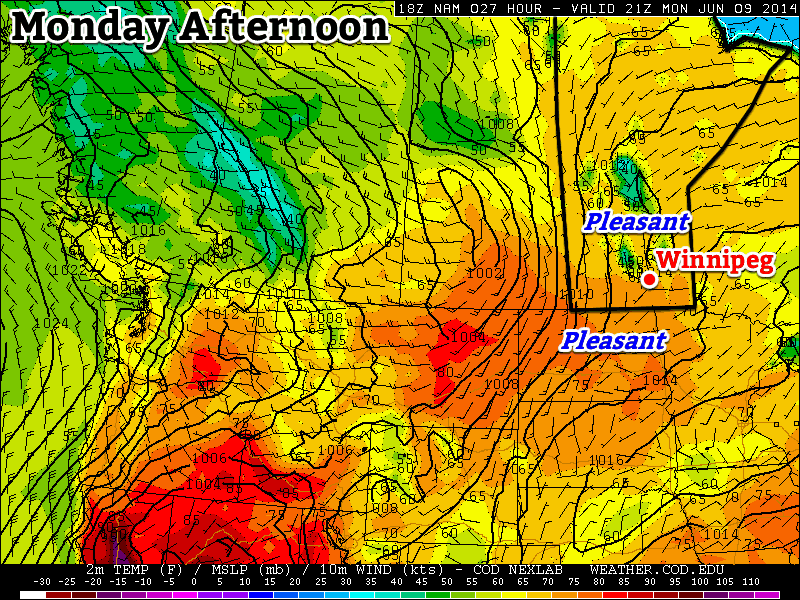
Today will feature near normal weather in southern Manitoba as temperatures climb into the mid twenties. There will be a chance of showers through the day as an upper-level impulse rolls through, but little in the way of accumulation is expected. Despite the calm weather in Manitoba, conditions just south of the border look to be quite different.

A very hot and extremely humid air mass are located over the eastern Dakotas and Minnesota today. This air mass will become extremely unstable by late afternoon, characterized by MLCAPE values of 4000-5000 J/kg (CAPE is a measure the potential energy/fuel for a thunderstorm), or perhaps even higher in localized pockets. Favourable wind profiles will allow for supercell thunderstorms and tornadoes early in this thunderstorm event, but cells will likely transition into a powerful convective system by mid to late evening. Given the potency of the thunderstorm environment tomorrow, all modes of severe weather will be possible, including very large hail and destructive winds. If your travels take you into this region today, you’ll want to pay close attention to the latest weather watches and warnings in the area.

Tuesday

Tuesday
26°C / 14°C
Mix of sun and cloud

Tuesday will be a relatively benign day. Temperatures will once again be in the mid twenties. Precipitation is unlikely as a surface high pressure system builds into Manitoba. Winds will be relatively light and from the north.

Wednesday

Wednesday
27°C / 15°C
Mainly sunny

The surface high from Tuesday looks to stick around for Wednesday, bringing continued pleasant weather to southern Manitoba. Temperatures look to be in the mid to upper twenties with light winds. Some precipitation may edge into western Manitoba late in the day as thunderstorms are potentially triggered to our west in Saskatchewan.

Long Range

The long range forecast looks to have ups and downs. Models strongly suggest that a low pressure system will move into Manitoba late this week, potentially bringing us some rain and generally unsettled conditions. Once that system exits the region we’ll likely return to more summer-like weather next week.

Fairly Normal Start to the Week

This week will start out with fairly normal conditions for early June with a chance for rain, and moderate temperatures.

Monday will be a nice day in southern Manitoba

Monday

Monday
22°C / 13°C
Mainly sunny

Today may start out with a bit of rain in the morning as a piece of upper-level energy swings through but skies should quickly clear, making for a pleasant day. Any rain that does fall in the morning will be light, so it won’t be a big deal. By the afternoon we should see mainly sunny skies with temperatures in the low twenties and light winds.

Tuesday

Tuesday
23°C / 10°C
Chance of showers or thundershowers

Tuesday will see the chance for showers and thundershowers in the Red River Valley and south-eastern Manitoba ahead of an approaching trough. Any thundershowers that develop will present the risk of small hail and gusty winds. For those areas that miss out on the showers and thundershowers, it will be a nice day with temperatures in the low twenties and a breezy south-west wind.

Wednesday

Wednesday
19°C / 5°C
Mix of sun and cloud

A cold front will blow through southern Manitoba early Wednesday morning, setting us up for a slightly cooler day. Highs on Wednesday will be in the upper teens in most areas (perhaps a few readings in the low twenties), with skies being a mix of sun and cloud by the afternoon. The wind will be breezy and from the north.

Long Range

The long range forecast suggests we’ll continue to see normalish weather for the foreseeable future. That means high temperatures in the low to mid twenties and the frequent chance for rain or thunderstorms (albeit generally of the non-severe variety).

Normal Weather Through Early Week

The first part of this week will feature fairly typical early-June conditions, with temperatures in the low twenties and a chance of rain.

 Areas along the International Border may see some rain on Monday
Areas along the International Border may see some rain on Monday

Monday

Monday
18°C / 9°C
Chance of Showers

Today will see a chance of showers over all of southern Manitoba. In areas near the International border, there may be more than showers, with periods of rain and perhaps even some embedded thunderstorms. Accumulations along the border should generally not exceed 15mm, but there could be locally higher amounts if any thunderstorms develop. In areas further north, such as Winnipeg, it should be a fairly uneventful day overall, with temperatures in the upper teens and a breezy north wind.

Tuesday and Wednesday

Tuesday
23°C / 10°C
Mainly Sunny
Wednesday
25°C / 13°C
Mainly Sunny

Tuesday and Wednesday look like uneventful days in southern Manitoba. Temperatures will be in the low to mid twenties with light winds and mainly sunny skies. There’s certainly nothing wrong with that!

Long Range

The long range forecast suggests we may see a risk of thunderstorms on Thursday, followed by cooler weather for late week into the weekend. We’ll likely rebound to seasonal or above-seasonal values at some point next week.

Fairly Normal Start to the Week

This week will start out with fairly typical conditions for this time of year. No significant weather is expected.

image

GEM-Regional predicted precipitation on Monday

Monday

Monday
image
Flurries
-4°C / -7°C

Monday will be a cloudy day, with a good chance of flurries. These flurries will be fairly disorganized in nature, but could amount to a couple of centimetres in many areas. Models do suggest that some localized areas could see close to 5cm by the time this area of snow completely dissipates on Tuesday morning. However, confidence is very low in terms of predicting which areas might be in for these slightly heavier amounts. As such, I’ll just suggest that any location in Southern Manitoba does stand a small chance of seeing close to 5cm if heavier periods of snow get stuck over the area. Temperatures on Monday will be in the low to mid minus single digits in most of Southern Manitoba. Parts of western Manitoba may get up around the freezing mark as the wind there will switch to westerly, giving a downslope flow.

Tuesday and Wedensday

Tuesday
image
Mix of Sun and Cloud. Chance of Flurries.
-8°C / -15°C
Wednesday
image
Mainly Sunny
-4°C / -7°C

Tuesday is a bit of a tricky forecast, albeit in a non-threatening kind of way. It looks like we may get stuck in low-level cloud and possible light flurries through the day. Alternatively, skies may clear and it could be a fairly bright and non-snowy kind of day. In either case, high temperatures will be in the mid or upper minus single digits with a breezy north-westerly wind.

Wednesday should see sunny skies return. Unfortunately, temperatures will remain stuck just below zero, as a stiff southerly flow prevents strong mixing and maximum temperature rises. As a result, we’ll see high temperatures once again in the low to mid minus single digits.

Long Range

The long-range still doesn’t look very spring-like unfortunately. Even worse than that, models continue to hint at a stormy pattern returning to southern Manitoba towards mid-March. If you’re hoping for spring, you’d better cross your fingers that a renewed storm track through our area brings rain, rather than more snow!