Snow Tapering Off Today

Today’s post will be short as I’m occupied with some family-related business.

Moderate snow pushed into the Red River Valley yesterday evening, bringing reduced visibilities and slippery conditions. Snow will continue through much of the day before tapering off.

Accumulated Precipitation From 00Z Friday to 00Z Saturday

GEM-GLB Accumulated precipitation from 00Z Friday to 00Z Saturday

Snowfall accumulations will generally be close to 5cm, however there will be a swath near the Trans-Canada highway between Brandon and Winnipeg that will likely see total amounts in the 5-10cm range. Snow should taper off by evening, and we’ll see an overnight lows throughout the RRV around -15°C.

Over the weekend, we’ll see mostly sunny skies with daytime highs near between -10° and -5°C, with overnight lows between -20°C and -15°C. The next chance for precipitation will come Monday with a passage of a warm front that will push our temperature up into the plus mid-single digits.

Calmer Weather On Tap (for Manitoba)

After a wild week of weather that featured heavy snowfall across many parts of Southern Manitoba conditions will begin to calm down. However, the same can’t be said for areas just to our south.

Surface Map Showing the Colorado Low

Surface map showing the forecast track of the Colorado Low

A major winter storm will impact portions of the North-Central United States just south of Manitoba. Areas such as Fargo, North Dakota, Minneapolis, Minnesota, and Aberdeen, South Dakota will be impacted by a Colorado Low system on Tuesday and Wednesday of this week. The hardest hit areas in South Dakota and Central Minnesota may see upwards of 30cm (1 foot) of snow. Wind speeds will also be high during this storm and as such the National Weather Service has issued blizzard watches for portions of the Northern U.S. Plains. Anyone who has travel plans to regions just south of the border may want to reconsider as this will be a significant and potentially life-threatening winter storm.

On our side of the border the weather will be considerably different this week. Temperatures for the first half of the week will be very reasonable. Highs on Monday will be in the -10 to -15C range in most of Southern Manitoba, which is unseasonably cold. Fortunately wind speeds will be light on Monday, making conditions fairly comfortable. By Tuesday and Wednesday temperatures will have increased with highs in most of Southern Manitoba reaching the minus single digits. Temperatures for the remainder of the week will remain mild as an approaching low pressure system develops a southerly flow over Southern Manitoba. The approaching low pressure system will probably reach Southern Manitoba on Friday, potentially bringing a bit of light snow along with it.

With meteorological winter nearly over many people are wondering what March has in store. Unfortunately, there is no clear signal as to how March will evolve at this time. Most models show generally seasonable conditions in Southern Manitoba for the first part of March with no signs of any major warm-ups or cool-downs. Nevertheless, with spring set to begin in just over 3 weeks you can certainly count on the fact that winter’s worst cold is behind us.

Meteorological winter is defined as December, January, and February. Solar (calendar) winter lags behind by about 3 weeks (December 21 – March 21). Meteorological seasons more accurately describe the type of weather that takes place in Southern Manitoba


Elsewhere in Weather News

Flash Flooding in Queensland, Australia

The southeast region of Queensland, Australia experienced flooding this week after more than 330mm of rain fell in some areas. Although heavy rainfalls are not that uncommon in the region, southeast Queensland was deluged with heavy rain the past couple weeks and the river system levels are quite high.

This week’s rainfall totals for Queensland, some areas topping 300mm in one week! (Source: Bureau of Meterology, Australia)

This week’s rainfall totals for Queensland, some areas topping 300mm in one week! (Source: Bureau of Meterology, Australia)

From Friday, February 24th to Saturday the 25th, a surface trough combined with an upper-level low intensifying over Queensland and slowly moving westward, caused the Bureau of Meteorology (BoM) to issue multiple warnings. (In the southern hemisphere low pressure systems spin clockwise and move westward as opposed to the northern hemisphere where lows spins counter-clockwise and generally move eastward.) The BoM had issued flash flood warnings, advising that some of the downpours could easily reach 150-200mm within a day. Severe weather bulletins had also been issued for storms associated with this system however the main threat was flash flooding.

Bridge leading into Cooroy has been destroyed by rising waters. (Source: The Courier-Mail)

Bridge leading into Cooroy has been destroyed by rising waters. (Source: The Courier-Mail)

The rainfall caused extensive damage to the road networks in the region, causing authorities to close more than 40 roads and urge residents to stay off roads and only travel for urgent reasons. More than 100 water rescues were made due to rapidly rising water levels and fast flowing streams turning into raging rivers in a matter of minutes. The town of Cooroy which had been impacted by very strong winds earlier in the week had now been cut off by rising waters as the roads heading in and out of town were flooded out. Since then, the water has receded and the town can now travel freely.

The weather should clear up though, as the forecast calls for minimal rain for the start of the work week, with only sporadic showers occurring every second day.

Elsewhere in Weather News has been provided by Matt

A Cooler Week Ahead

A cooler week is in store for us as we move into the last month of meteorological winter. Temperatures don’t, however, look like they’ll be too far from normal through most of the week.

Surface Pressure Map

Surface Pressure Map – valid 12Z Tuesday, February 6, 2012

With the passage of a cold front this morning, gusty northerly winds will usher colder air into Southern Manitoba. As a result temperatures will fall throughout the day today, with midday conditions in the mid-minus single digits. There will be a few scattered flurries this morning through Southern Manitoba as the cold front works its way through the area, however there will be no significant accumulations with them. Tonight, a strong area of high pressure will build into Southern Manitoba, with the central pressure expected to be as high as 1045mb. This will bring significantly colder temperatures than we’ve enjoyed over the past week to our area overnight, with lows expected to be near -20°C in Winnipeg and as low as -25 or -26°C in some areas in the Red River Valley. Tuesday won’t be an extremely cold day as a weak warm front will push into our area from the north, but it will still be colder than we have been used to lately with highs unlikely to exceed -10C. Conditions through Wednesday will be slightly warmer, with highs expected to rise back up into the minus single digits.

Friday Morning GEMGLB Forecast Temperatures

Forecast surface temperatures from the GEM-GLB model valid 06Z Friday, February 10th with analysis. The thick black line represents the cold front.

There is some uncertainty as to how the weather will unfold later this week. Models are hinting at the potential for another push of cold air on Thursday into Friday as another cold front sweeps through the province. Models currently differ on the exact strength of the cold push, however, as shown in the image above, some models push temperatures as low as -30°C back into Southern Manitoba. Which if it comes true, we can at least take solace that we don’t live in Northern Saskatchewan, where temperatures are forecast to be as low as -45°C!


Elsewhere in Weather News

Europe Battles Cold and Snow

This past week Europe was battered with what Canadians would call a “light snowfall” where many parts of the United-Kingdom, including London, received 10cm of snow this past weekend. The European infrastructure isn’t equipped to handle a snow storm of such magnitude which was affirmed by the fact that there were widespread airport cancellations and traffic was crawling to a standstill – some drivers were even stuck in their cars on the freeways overnight. The storm also prompted the UK Met offices to issue freezing rain warnings and cold weather alerts. The snowfall was due to a warm front pushing inland off the Atlantic Ocean and clashing with colder air that was present in the region prior, thanks to another low pressure system off to the east. The snow storm that has been wreaking havoc is forecast to lift and leave the area by Tuesday morning, leaving warmer temperatures behind and clearer conditions to come.

Surface Map for the UK

System’s analysis with the warm front arriving inland, clashing with the colder air to the east (occluded front). (Source: Met Office: UK)

Cold weather also affected other parts of Europe including Ukraine and Italy, with Ukraine being one of the hardest-hit of the Eastern European countries and experiencing tragedy. Kiev, Ukraine’s capital city, normally has temperatures averaging minus five Celsius for the month of February. During this cold snap however, temperatures dipped lower than minus thirty Celsius and many people have died – over 300 as of this posting. Temperatures for the next week are forecast to remain well below average, with highs only reaching the minus teens.

Snow in Rome

City of Rome, largest snowfall in two and a half decades. (Source: Dailymail)

In Rome, Italy, the city has received its largest snowfall in two and a half decades. The city was buried in ten to twenty centimetres, leaving the city paralyzed and people freezing in their houses, since homeowners are only allowed twelve hours of heating per day (to reduce emissions). As the low pressure system plans to stick around for a couple more days, Rome will experience well below average high temperatures of about five Celsius (average of thirteen Celsius).

Surface Map of Europe

Europe’s system analysis, Feb 5th, showing both lows impacting Europe. (Source: Intellicast)

Elsewhere in Weather News has been provided by Matt

Much Nicer This Week

Temperatures this week will be a big improvement over last week. By mid-week we might even take a run at the zero mark.

GEM-GLB Temperatures on Wednesday, January 25, 2012

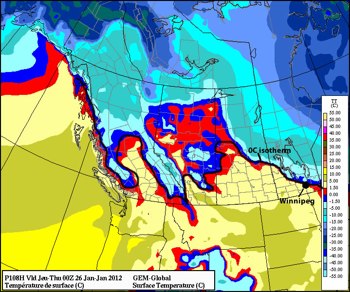
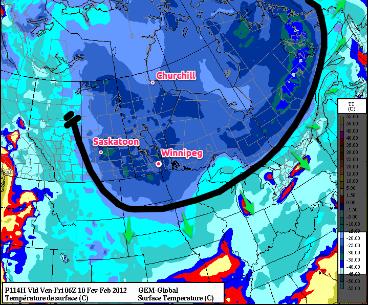
High temperature forecast for Wednesday, January 25, 2012 – areas south of black line are forecast to be 0°C or warmer

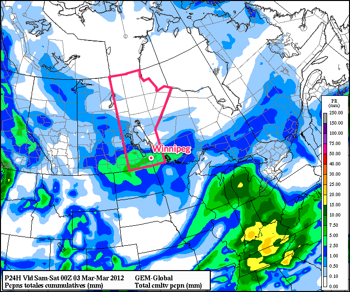
Temperatures through the first few days of the week are expected to be around or above normal (normal high being -13°C). Monday will be around normal, with highs in the mid minus teens in Southern Manitoba. However, Tuesday and Wednesday will be much warmer. Highs on Tuesday will likely break into the minus single digits in most areas, while highs on Wednesday will be near the zero mark. The GEM model is showing high temperatures reaching (or exceeding) the zero mark on Wednesday in much of Southern Manitoba. The GFS model likewise shows highs around zero on Wednesday. After a really warm Wednesday, the last two days of the work-week will be cooler.

The warmer weather is a result of upper-level ridging building into the Western Prairies, which will return our milder, west-to-southwest flow through the upper atmosphere, instead of the cold northwest-to-northerly flow we’ve been influenced by over the past week.

Our next chance for snow will likely come with the same system that will bring us the warm temperatures this week. A frontal boundary will sweep the warm air from Southern Manitoba later on Wednesday and may generate some snow in its wake. If we do see snow under this scenario, amounts will generally be light…but blowing snow could be an issue as the cold front is expected to usher in gusty north-west winds.

NAEFS Long-range Prediction

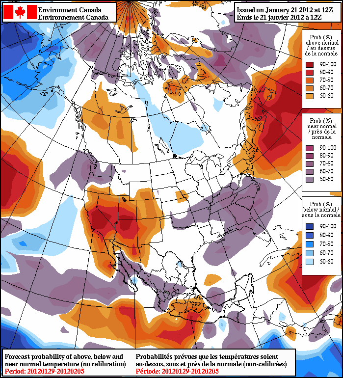
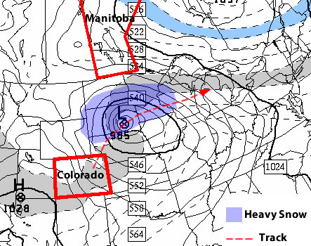
NAEFS Long-range prediction – January 19 to February 5

In the longer range I don’t see an immediate return to extremely cold weather. On the other hand, don’t expect early January type warmth either. Most indications suggest that we’ll end January with weather that is right around normal. The ensemble model, as shown above, gives a good indication of what type of weather to expect in the longer range. For most of the winter it has done a pretty good job in providing advance warning when major warm-ups or cool-downs are coming. Right now it doesn’t show much of anything, a sign that we’re likely to cruise into February without any highly abnormal weather.


Elsewhere in Weather News

Large Low Hits US Northwest

This past week a major snowstorm took hold of the US northwest, bringing a mixed bag of precipitation across the region. Various parts of Washington State were paralyzed, especially the west coast, by freezing rain initially (Wednesday/Thursday). The freezing rain brought down power lines and left about 200,000 people in the dark. It also wrecked havoc on the roads, forcing the state to shut down a couple major interstates and prompting Governor Gregoire to issue a state of emergency.

Weather Warnings across the northwest US

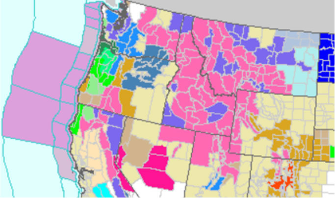
US Northwest littered with snowfall, freezing rain, and flood warnings. (Source: US National Weather Service)

Following the freezing rain, the storm brought heavy snow where totals topped 15cm in many locations across the Northwest. Here’s a short list of some of the higher snow accumulations throughout the region (Monday-Thursday):

  • 127cm – Mount Hood Meadows, OR
  • 60cm – Covington Mills, CA
  • 18cm – Seattle, WA

Many locations in Oregon and California also received significant rainfall with this low as well as strong wind gusts. A complete storm summary, made available by NCEP is available here.

Moisture arriving along the western coast of the US

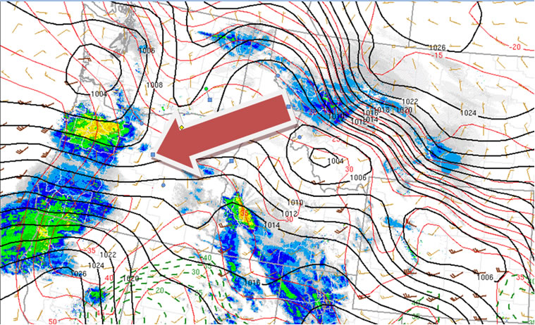
Atmospheric river arriving inland on the US Northwest coast. (Source: SPC)

This unusually strong system resulted from a large amount of moisture being drawn with south-west winds from as far south as Hawaii. The so called “atmospheric river” then flows inland, in this case in Northwest US, and subsequently drops large amounts of precipitation.

Tropical Storm Funso Spins Up

Satellite image of tropical storm Funso

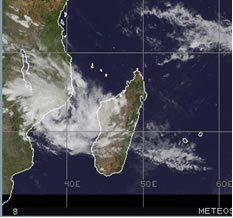
Cyclonic storm between Mozambique coast and Madagascar January 22. (Source: Meteosat 7; CIMSS)

A strong tropical storm has spun up on Mozambique’s east coast (African coast) in the last couple days. The storm is located in the Mozambique Channel and is predicted to intensify with the formation of a cyclonic eye. The warm sea surface temperatures (SST’s) and moist air trapped in the channel are contributing largely to the strengthening of the cyclone. It is expected to evolve into a strong cyclonic storm by Monday afternoon after the main center of the storm moves back over water. The main worries with this cyclone are the strong winds associated with it and flooding due to the slow moving nature of the storm. Mozambique’s coast will be affected significantly before the storm gets steered towards the south-west later in the week.

Elsewhere in Weather News has been provided by Matt