Severe Thunderstorm Threat Returns to Southern Manitoba

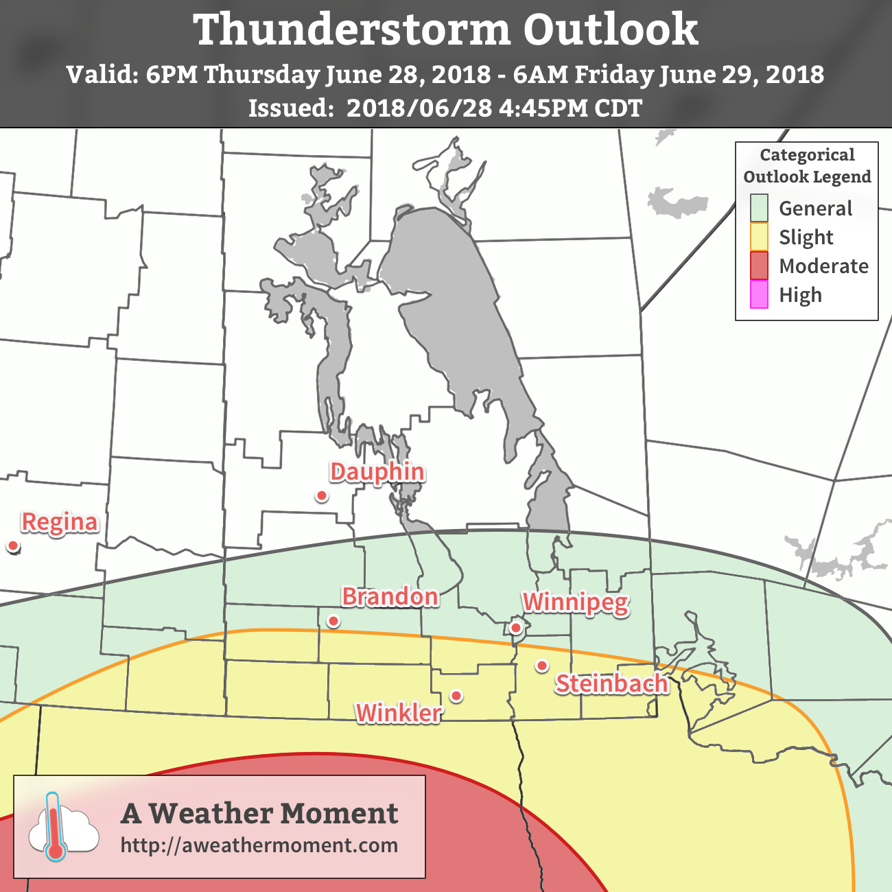
Winnipeg will see several rounds of thunderstorms over the next 36 hours, some of which may be severe.

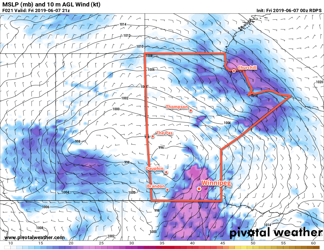
A sharp long-wave trough moving into the region will produce several rounds of thunderstorms over the Red River Valley through the next 36 hours. The initial wave of thunderstorms is pushing through the Red River Valley already. These storms produced a variety of severe weather overnight as they moved through Saskatchewan and southwest Manitoba and will continue to pose a slight chance of producing severe hail or wind gusts.

A large mesoscale convective system developed over SE Saskatchewan into Manitoba on Thursday night and is bringing strong to severe thunderstorms to the Red River Valley this morning.

After those storms move through, Winnipeg should see mixed skies with temperatures increasing to a high near 25°C. Winds will be breezy out of the southeast at 30 gusting 50 km/h.

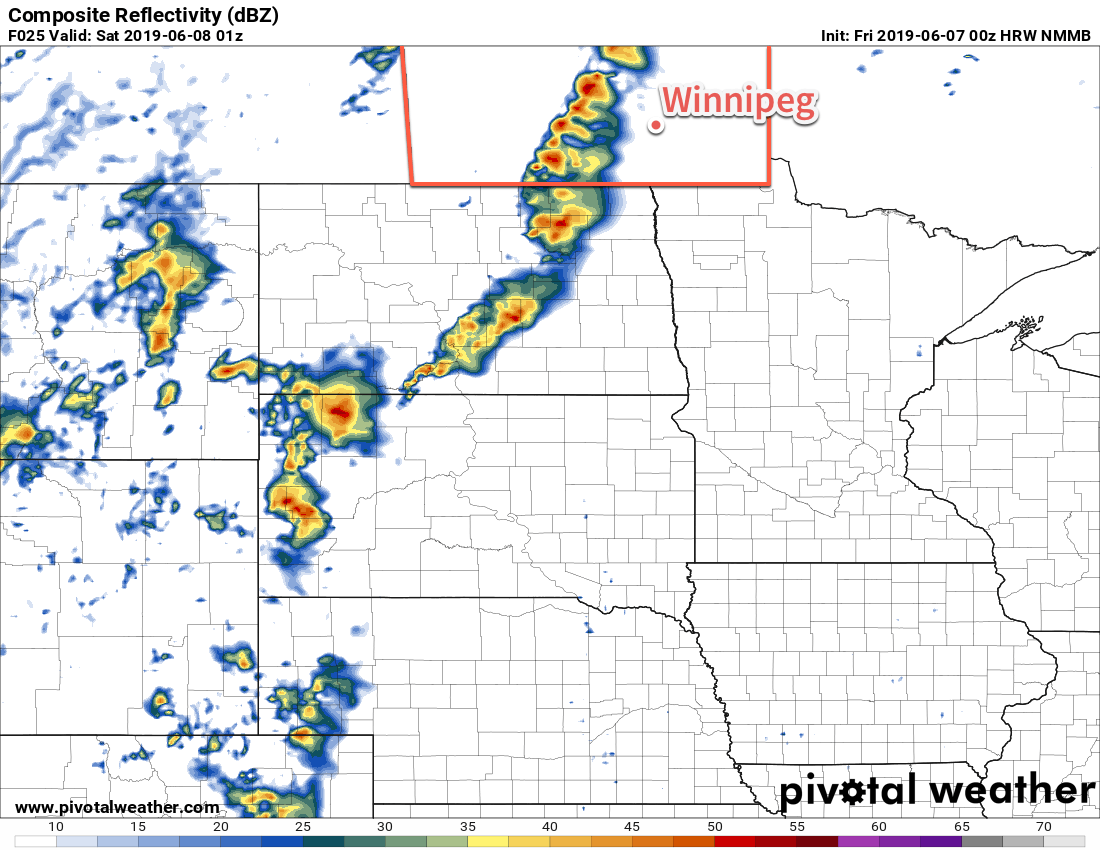
Another round of thunderstorms will develop later today, likely producing a swath of severe weather extending from the southwest corner of the province right through to Ontario. The storms will begin this afternoon over the southwestern corner of the province and then move through the Red River Valley through the evening. These thunderstorms will be capable of large hail, severe wind gusts, and torrential downpours causing flash flooding.1 It will be a complex and dynamic system this evening, so be sure to stay aware of any watches or warnings issued by ECCC later today.

Another line of strong to severe thunderstorms will move thorugh southern Manitoba later today.

Saturday morning will likely bring a brief reprieve before an upper low moves into the region. As it moves in, more showers and thunderstorms are forecast to develop. There will be less energy for the storms to utilize, but they may still produce some hail and rather heavy downpours.2 The unsettled conditions will keep things cool with a high near 20°C expected in Winnipeg. Winds will be light to start the day, but pick up out of the northwest late in the day. Temperatures will drop to a low near 12°C with a northwest wind of 20 to 30 km/h and a continued chance of showers on Saturday night.

Conditions will finally settle for Sunday. Skies will gradually clear out with a northwest wind of 20 to 30 km/h. Winnipeg can expect a high near 19°C. A ridge of high pressure will move in on Sunday night, bringing calm winds and a low near 6°C.

Long Range Outlook

Much of next week looks to bring variable cloudiness and warm to seasonal temperatures. By the end of the week, conditions may turn cloudier with a chance of showers.

Today’s seasonal daytime high in Winnipeg is 17°C while the seasonal overnight low is 5°C.

  1. MLCAPE values near 2000 J/kg combined with 35 knots of deep shear and a perpendicular warm front orientation should support squall-line structures with large hail and strong winds. PWAT values climbing to 50 mm will ensure that the thunderstorms produce heavy rain, and rapid accumulations with flash flooding is possible in any areas that see slower-moving or training thunderstorms.
  2. MLCAPE values near 500 J/kg will combine with bulk shear values of 40 to 50 knots to produce widespread showers with embedded thunderstorms. PWAT values of 35 mm will support moderate to heavy rainfall rates.

Severe Thunderstorm Threat To Start the Week

Winnipeg’s week will start off with hot and humid conditions developing ahead of a trough of low pressure. As it moves into the region, it will bring a risk of severe thunderstorms beginning Monday afternoon. Unsettled conditions will continue through Tuesday before settling for Wednesday.

Today’s main weather-maker will be a trough of low pressure slowly working into the region. To start the day, the city might see some showers or thunderstorms if the overnight convection that started in Saskatchewan makes it this far. Then, temperatures will rise into the upper 20s through the morning with increasingly humid conditions. As the trough slumps southwards this afternoon, it will bring a broad severe thunderstorm threat to the region. The hot and humid conditions will provide ample energy for thunderstorms, the trough will focus development, and winds will be aligned in a way that will support long-lived thunderstorms. All manners of severe weather will be possible this afternoon and into the evening. Be sure to stay aware of any watches or warnings issued by Environment and Climate Change Canada.

ECCC is forecasting a threat of severe thunderstorms over southern Manitoba today.

You can view Environment and Climate Change Canada’s thunderstorm outlook and discussion for today in our Bulletin Viewer.

The thunderstorm threat will persist into the evening with the thunderstorm activity moving out of the province near midnight. Temperatures will dip to a low near 19°C with light winds.

Showers or thunderstorms are on the way for much of the Red River Valley on Tuesday as a low pressure system moves along the American border. Temperatures will be cooler near 23°C, but the humid conditions will stay in place. The city will see light northeasterly winds of 10 to 20 km/h through the day. Heading into the night, the city will still see a good chance for showers. As the low moves off to the east, winds will pick up out of the northwest to around 30 gusting 50 km/h and persist into Wednesday morning. Winnipeg should see a low near 16°C with some of the humidity easing overnight.

The city will see a chance for showers Wednesday morning, then skies will clear midday leaving the city with plenty of sun. Temperatures will climb to a high near 24 or 25°C with winds easing to around 20 km/h in the afternoon. The winds will usher the humidity out, making for more comfortable conditions in the afternoon. Temperatures will dip to a low near 15°C on Wednesday night with a few clouds and light winds.

While many parts of the Red River Valley will appreciate rain, it’s always difficult to pinpoint where – and how much – any one place will get when dealing with convective systems like these. That said, it seems possible that several areas may see 15 to 35 mm of rain by Wednesday morning. Locally, some areas could see less or more depending on how exactly the convection develops.

Long Range Outlook

The rest of the week will bring daytime highs in the upper 20s and overnight lows in the mid- to upper-teens. Another low pressure passing through on Thursday night will bring another chance of showers or thunderstorms to the region. Looking towards the weekend, Saturday looks quite nice, but by Sunday hot and unstable conditions are forecast to return to the region.

Today’s seasonal daytime high in Winnipeg is 26°C while the seasonal overnight low is 13°C.

Hot & Windy Saturday Brings Thunderstorm Threat

Today will be a scorcher over southern Manitoba as strong southerly wind pump hot and increasingly humid air northwards. With that heat, though, will come a fair amount of instability and one of the first widespread severe thunderstorm threats of the season.

To start the day, some elevated convection will move across the region, most likely through the Interlake. These thunderstorms may be strong to severe, but should remain north of the Red River Valley. Although the storms should pass north of Winnipeg, the city will still see some passing cloud as they move by. These storms and their cloud cover should clear out by midday. As the sun comes out, the wind will pick up. A tight pressure gradient over the region1 will produce southerly winds up to 50 gusting 70 km/h today, helping heat and moisture surge northwards out of the United States. With those strong winds in place, Winnipeg will see temperatures climb to a high near 33°C. It will also get a tad more humid as the day goes on as dew points rise into the mid-teens.

Strong southelry winds will be in place over southern Mantioba this afternoon. To the west, a trough of low pressure extending southwards into the United States may trigger a line of thunderstorms late in the day.

By late in the afternoon, the thunderstorm threat will begin to build. A trough of low pressure over southwestern Manitoba into the Interlake may trigger the development of thunderstorms. If they develop, they’ll likely be strong to severe with primary threats of large hail and strong winds. Any of these thunderstorms that develop will move eastwards towards the Red River Valley through the evening. The focus then turns southwards to the Dakotas. A shortwave lifting northeastwards through the state will trigger convection late in the day. These thunderstorms will grow upscale and expand in coverage overnight. As the evening progresses, this blossoming area of thunderstorms will gradually spread across southern Manitoba. The potential for strong to severe thunderstorms exists tonight, with large hail and damaging wind gusts the primary threats. The thunderstorms should be through the Red River Valley by Saturday morning.

Temperatures will remain mild on Friday night with a low near 19°C. Those strong southerly winds will ease into the 20 to 30 km/h range this evening and then diminish to light overnight.

If thunderstorms are able to develop along the trough, southern Manitoba may see a line of thunderstorms marching towards the Red River Valley early in the evening.

Saturday will bring plenty of cloud to Winnipeg as the low pressure system responsible for all this heat and instability moves through. Temperatures will be much cooler with morning temperatures near 18°C dropping to 14°C through the day. Winds will gradually pick up out of west into the 20 to 30 km/h range. More showers with the risk of thunderstorms are likely to develop later in the morning and persist through much of the afternoon. Conditions will calm down on Saturday night with some clear breaks developing towards Sunday morning. Winnipeg should see a low temperature near 9°C.

Sunday will bring seasonably cool conditions to Winnipeg, but things will get a chance to dry out. The city should see a high near 19°C under partly cloudy skies. Westerly winds near 30 km/h will be in place for much of the afternoon before diminishing in the evening. Winnipeg will see a low near 8°C with just a few clouds on Sunday night.

Long Range Outlook

Next week will bring seasonably cool temperatures with daytime highs around 20°C and overnight lows close to 10°C. The city will see variable cloudiness through the week, and a couple of passing disturbances may bring a chance or two of showers through the week. Temperatures should begin to warm up near the end of the week, but that may bring a return to unsettled conditions.

Today’s seasonal daytime high in Winnipeg is 23°C while the seasonal overnight low is 10°C.

  1. The tight pressure gradient is a result of a 996 mb low over western Manitoba squishing against a ridge of high pressure extending through SE Minnesota into Iowa.

Thunderstorms Expected Across Southern Manitoba Overnight

A developing low pressure system in North Dakota will generate a widespread thunderstorm threat this evening and overnight that extends into southern Manitoba.

In North Dakota, there’s very high confidence that there will be some truly dangerous thunderstorms later today. A confluence of all severe weather parameters – extremely high amounts of energy, favourable wind profiles with high amounts of shear, a clear and potent focus for thunderstorm development – has led the SPC in the United States to issue a “moderate risk” thunderstorm hazard for the state today. Further north, things become a little more unclear and conditional in southern Manitoba.

The overall synoptic setup is summarized succinctly in the PASPC’s daily significant weather discussion:

[…] approaching long wave upper trough creating favourable synoptic setup tonight/overnight for a developing Colorado Low convective complex. This begins as a rapidly deepening baroclinic surface low in the Northern States with associated associated severe surface-based convection beginning this afternoon or evening.

So a rapidly deepening Colorado Low-type system will develop severe thunderstorms over North Dakota this afternoon. Continuing:

[As the convection] evolves and severe elevated convection becomes dominant through the night. Big question is where does [it] go? Details vary widely amongst model solutions, with some bringing severe convection clipping SE Saskatchewan then moving through southern Manitoba, and others confining the bulk of the severe weather to the United States.

And that is the big question. Where will the thunderstorms develop tonight? Here’s our thoughts, omitting much talk about what will happen in North Dakota.

The primary focus for thunderstorm development tonight in southern Manitoba will be split between two features. The first will be a warm front draped west to east along the Canada/US border for much of the night before lifting a bit further north over southeastern Manitoba late overnight. The second will be a mid-level shortwave that moves across southern Manitoba late overnight into Friday morning.

These two features will support independent areas of thunderstorm activity, then merge into a single area as the shortwave moves over the warm front.

There are two primary ways this could play out; we’ll cover the most likely way and then cover Plan B©.

Most Likely Situation

A few isolated showers or non-severe thunderstorms are possible along and north of the warm front late this afternoon across northern North Dakota and far southern Manitoba. A more organized area of thunderstorms will develop over western North Dakota this evening and become the focus for thunderstorm activity for the following 12 hours. The thunderstorms will develop into a QLCS – quasi-linear convective system – mid-evening and accelerate eastwards. The mid-level shortwave moving into the region will draw moisture northwards from the QLCS across the border into southern Manitoba, supporting an area of showers and thunderstorms into southern Manitoba.

This activity will develop over the southwestern corner of the province sometime between 9 and 11 PM, then spread into the Red River Valley overnight.

AWM Thunderstorm Outlook valid 6PM Thursday June 28 to 6AM Friday June 29, 2018

Much of the severe weather in this scenario will be confined to North Dakota. There would be a slight risk of a severe thunderstorm south of the Trans-Canada Highway in Manitoba with primary threats of overland flooding due to heavy rainfall and large hail.

The convection will clear out overnight or early Friday.

Plan B

The alternative solution is one where the QLCS developing in North Dakota ends up surging eastwards, breaking away from the mid-level shortwave and becoming its own entity as it races towards Minnesota. In this case, less thunderstorm activity would be seen around the mid-level shortwave as it pushes into Manitoba overnight, however the organized southerly flow riding over the warm front would be undisturbed, likely allowing elevated thunderstorms to fire up overnight across far southern Manitoba. These thunderstorms, were they to form, would be more scattered in nature, but would pose a marked hail threat alongside torrential rains.

Not As Bad As It Looked Just 12 Hours Ago

In the end, the situation doesn’t look quite as bad over Manitoba as it did earlier this morning. If our expected solution pans out, most areas should just see a decent soaking with 15 to 30 mm of rain. Localized higher amounts will be possible, particularly closer to the US border. If the hail stays away, then we could be getting up tomorrow in the wake of a much-needed rainfall.

That said, if Plan B is what happens, or a hybrid of our expected solution and Plan B, then residents will need to prepare for the potential for large hail and localized flooding. We’ll be keeping an eye on things and likely issue one last brief update on our social media accounts later this evening.