Showers Give Way to Hot & Humid Weather

A weakening disturbance will push through the province today, bringing some rain to the region. As it clears out, the heat and humidity will build back in for week's end sending daytime highs back towards the 30°C mark.

Today will see Winnipeg stuck under overcast skies as a disturbance rolls through the region, bringing some showers to the region. The best chance for precipitation will begin mid- to late-morning through the early afternoon, with diminishing chances later in the afternoon as the system moves out of the region. The cloud cover and shower activity will keep things a bit cooler with daytime highs near 21°C.

Skies will clear in the evening as the disturbance departs the region and temperatures will fall to a low near 12°C. Thursday will be a beautiful sunny day across the Red River Valley with a high near 24°C and light winds. Temperatures will dip to around 14°C on Saturday night with just a few clouds.
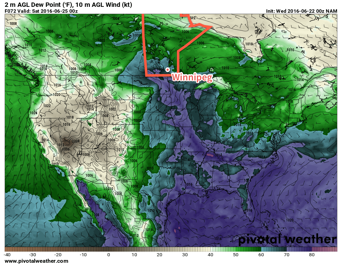
NAM Forecast 2m Dewpoint valid 00Z Saturday June 25, 2016
A plume of higher dewpoints, shown by the blue and purple colours, is forecast to move into southern Mantioba on Friday.
A weakening disturbance will push through the province today, bringing some rain to the region. As it clears out, the heat and humidity will build back in for week’s end sending daytime highs back towards the 30°C mark.

Friday will see a return of the heat and humidity as a southerly flow re-develops over the Red River Valley. Winds will strengthen to around 30 km/h out of the south ahead of a major developing weather system in the western Prairies. Temperatures will climb to the upper 20's in the afternoon with a few clouds moving into the image. Perhaps more notably will be the humidity, which will surface through the day after northwards transport on Thursday night. From a relatively comfortable dewpoint of 12-13°C in the morning, by the end of the day the dewpoint will climb into the 18-20°C range, making for quite a muggy afternoon.

Heading into Friday evening, more cloud will move into the Red River Valley with a risk of showers or thunderstorms. It's early at this point, but there may be a slight risk of severe thunderstorms throughout the Red River Valley, including Winnipeg, on Friday evening.

Long Range

Saturday will be a warm and very humid day that will likely bring mixed skies and the risk of thunderstorms. Sunday looks to be much cooler with more comfortable humidity with a continued chance of showers or thundershowers as a large upper low moves over the province.

Winnipeg’s seasonal daytime high is currently 24°C while the seasonal overnight low is 12°C.
Unsettled Weekend Ahead

Unsettled weather will continue through the weekend as multiple disturbances ripple across Southern Manitoba, bringing mixed skies alongside a few chances for rain.

Yet another round of nocturnal convection1 will roll through this morning just ahead of a weak cold front slowly pushing eastwards across the Red River Valley. As of writing this2 there is still some uncertainty as to how extensive the convection will become, but best indications are that we could see a few showers or thundershowers early this morning as a more intense area of convection passes to the south. After that, Winnipeg & the Red River Valley should see clearing skies through the morning, especially once the "cold" front moves through.

Behind the cold front, westerly winds will ease the humidity that has built into the region over the past two days as dew points drop from the upper teens back towards the 10°C mark. With drier weather and sunny skies, temperatures should climb to a high near 27 or 28°C throughout the Red River Valley with winds up to 20-30km/h out of the west-northwest. Expect partly cloudy skies overnight with a low near 15°C.

Saturday will bring more cloud to the region as mixed skies develop through the morning with a chance of some light shower activity through the Red River Valley. Things should clear out by the evening, and the late day sun should push us to a high near 26°C.

While models keep the bulk of precipitation to our south on Saturday, a few light showers are possible thorugh the Red River Valley.

Winds will shift back around to the south late in the day, beginning to bring more humid air back into the region; with dew points expected to rise back into the mid-teens overnight, overnight lows will be kept fairly warm at around 17°C. We'll see a few clouds overnight.

Sunday will see yet another disturbance move through the region bringing another chance of showers or thunderstorms. The main threat for precipitation will occur through the morning hours, followed by skies becoming mixed in the afternoon. Daytime highs should be around 26 or 27°C with muggy conditions in place much of the day as dew point values hover around 17°C. As skies clear, gusty winds will pick up out of the west to around 30 km/h.

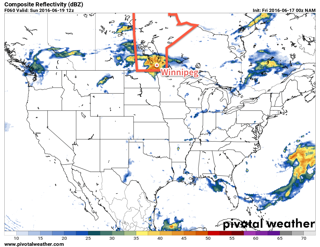
This simulated RADAR image from the NAM shows a large area of convective rainfall moving through the Red River Valley on Sunday.

Drier air will push in Sunday evening, helping overnight lows dip to a cooler 13°C or so with just a few clouds.

Long Range

Unfortunately, things don't look much better to start off next week. Another round of showers are possible late Monday through the overnight period as a disturbance slumps through from the northwest. Afterwards, though, it looks like we might see a few dry days with daytime highs ranging from the low 20's to the upper 20's.

  1. Nocturnal convection is the term applied to thunderstorms that persist through the overnight period. They are different from typical thunderstorms in that they get their heat and moisture from features detached from the ground.
  2. Currently around 10PM on Thursday evening.

Mixed Conditions Through Remainder of Week

Conditions will be mixed across Winnipeg & the Red River Valley through the remainder of the week with today's wet weather & seasonal temperatures giving way to warmer conditions with unsettled conditions building back in for the end of the week.

Today will start off with showers across the southern Red River Valley; there's a chance that we'll see some of the activity here in Winnipeg, but so far this system has been very difficult to get a handle on. Winnipeg may see the precipitation edge into the city this morning, but there's about an equal chance that it will stall just to the east of the city and never make it in.

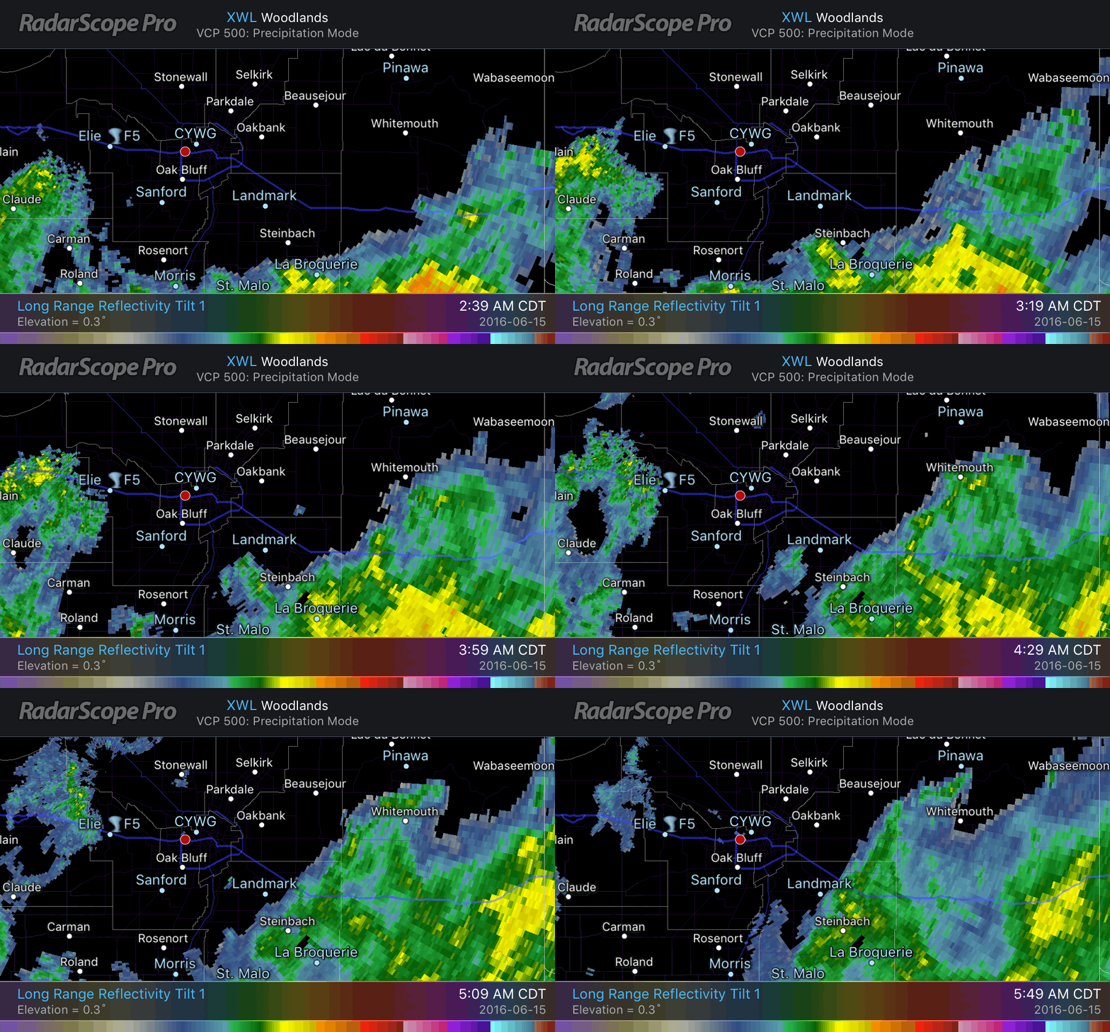
Radarscope – Woodlands 0.3° Reflectivity
An area of rain is pushing towards Winnipeg this morning.

By this afternoon, the rain should head back off towards Ontario and Winnipeg will be left with cloudy skies that will clear through the afternoon. Temperatures will climb towards a high of 23°C in Winnipeg today, with highs of 22-25°C across the Red River Valley. Expect a low near 15°C tonight under mainly clear skies.

Thursday will be a very nice day through the Red River Valley with a few clouds and much warmer weather. Daytime highs will climb around 28°C while a breezy south-to-southeasterly tap into higher moisture to the south, pushing dew points into the upper teens. This will make things feel slightly muggy, and that high of 28 feel closer to something in the mid-30's. A frontal wave passing through in the late afternoon will bring a risk of thunderstorms to Winnipeg & the Red River Valley through the evening hours. Temperatures will fall towards a low of 18°C under mixed skies overnight.

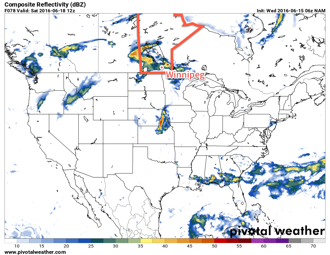
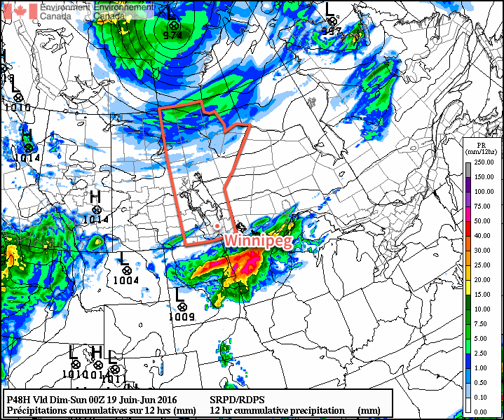
This simulated RADAR image shows precipitation moving through the Red River Valley on Friday night.

Friday will bring mixed skies to Winnipeg with drier air moving in behind the passage of a cool front in the morning. Temperatures will still climb to a high near 28°C once again, but by late afternoon significantly more cloud will begin moving into the region as the cool front rebounds and begins pushing back through the region. In the evening, showers and thunderstorms will be possible across the Red River Valley as the warm front slowly pushes northwards. Temperatures will fall to a low near 18°C once again on Friday night.

Long Range

The weekend is looking like it could be a wet one once again. Currently a low pressure system is forecast to move through the region on Saturday, which would likely bring a rainy day to the region with 15-25mm of rain possible. Things will improve a bit on Sunday as the system leaves the region, but a slight chance of showers may linger through the day.

Daytime highs will be in the low- to mid-20's and overnight lows will dip down to the mid-teens.

Winnipeg’s seasonal daytime high is currently 24°C while the seasonal overnight low is 11°C.

Unsettled Friday Leads to Pleasant Weekend

A showery and unsettled end to the week will mark the final day with precipitation before a stretch of drier weather builds into the Red River Valley for the weekend and into the first half of next week.

Today will be a rather unsettled day for Southern Manitoba as an upper-level low tracks into southwestern corner of the province. This morning starts out with the remnants of overnight convection tapering off over the Red River Valley, then attention will shift westwards as further thunderstorm development focuses along a trough extending from northeastern North Dakota back towards southeastern Saskatchewan.

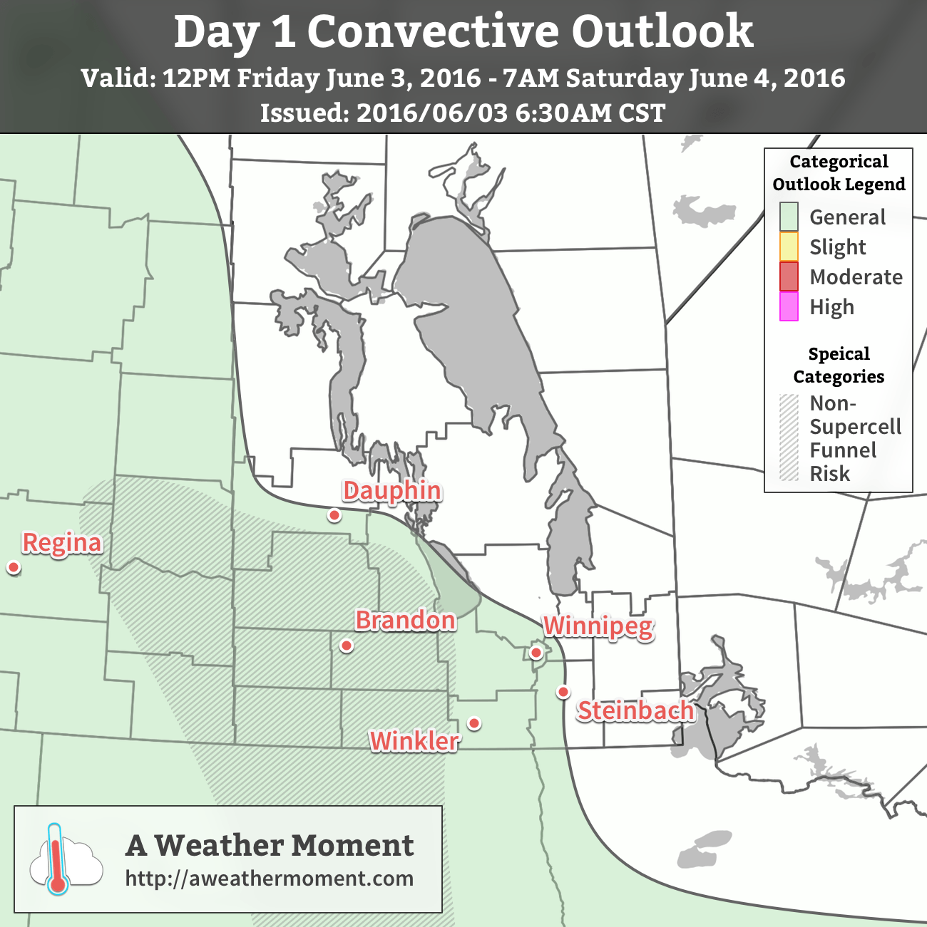
AWM Day 1 Convective Outlook for June 3, 2016

In general, scattered non-severe thunderstorms are possible throughout western and south-central Manitoba today. MLCAPE values of 400-800 J/kg will be enough to help some thunderstorm development occur, but weak shear and unfavourable moisture profiles will limit their strength. The main area of note runs from Yorkton, SK into southwestern Manitoba then southward into North Dakota, indicated by the hatched area on the map. In this area, a surface trough combined with better daytime heating and the approach of the upper-level low will introduce the possibility of some non-supercell funnel clouds as thunderstorms develop midday into the afternoon. These can often be eye-catching, but generally pose little threat and are short-lived. That said, if a non-supercell funnel cloud touches the ground, it is considered a tornado, although they too are also typically weak and short-lived.

In Winnipeg, the best chance for shower or thundershower activity will be this morning as any remnants move into the Red River Valley. The remainder of the day will be cloudy with a slight chance of some showers or thundershowers re-developing in the afternoon. Expect a high near 20°C with winds out of the southeast at 15-25km/h. Skies will clear this evening as temperatures drop to around 12°C.

Dry & Mild Weekend

The weekend, on the other hand, will be comparatively pleasant in Winnipeg & the Red River Valley. Skies will be partly cloudy to mixed on Saturday and mainly sunny on Sunday. Daytime highs both days will be in the low 20’s with overnight lows in the low teens. Winds will be fairly light out of the northwest on Saturday at 10-20km/h, but Sunday will be winder with northwest winds to 30-40km/h.

Winnipeg’s seasonal daytime high is currently 22°C while the seasonal overnight low is 9°C.

Forecast Update – Unsettled Weather Continues for Saturday

A bit of an update is required for today’s forecast as this weather system has evolved in a slightly different way than was expected when originally written on Thursday night.

The overall pattern has progressed to the east more slowly than originally thought, largely in part due to the stalling of an upper low in northern Minnesota. As a result, cloudier skies have remained in the Red River Valley, and some precipitation that was expected to be to our east today has not yet past.

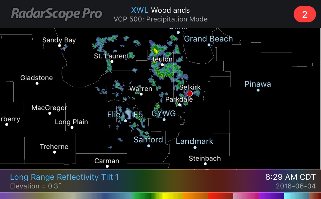
Radarscope Reflectivity - 8:20AM June 4, 2016
A weak area of showers descends towards Winnipeg from the Interlake.

For Winnipeg, well see a few light showers through the morning hours as a weak area of lift moves through from the Interlake. The extent of the showers will be fairly limited and largely confined to the northern half of the Red River Valley. These will taper off by mid-day, but be replaced by a chance for the development of afternoon showers with a slight risk of a thundershower as a trough moves through the region. This trough was fairly active yesterday, but will be far more benign today as less upper-level support is in place. The best chance for showers this afternoon will be over southeastern Manitoba through the Whiteshell and down towards Sprague.

Once we start clearing out for the afternoon, we should still be able to reach our high near 21°C-22°C with light winds.