Summer Weather Turns Unsettled at Weeks End

Southern Manitoba is in the middle of one of the most pleasant stretches of summer weather so far this year; humidity is relatively low with plenty of sun and daytime highs sitting in the mid-to-upper 20’s. This beautiful weather will continue for another couple days before an upper-level low pressure system begins impacting our region on Friday, bringing unsettled weather back to the region.

Wednesday
26°C / 13°C
Mainly sunny

Thursday
26°C / 18°C
Mixed skies with a chance of showers in the evening

Friday
26°C / 15°C
Chance of [thunder]showers

Today and tomorrow will both be beautiful days with highs around 26°C and light winds as a ridge of high pressure moving through the province quashes any unwelcome weather. Both days will also feature ample sunshine and fairly light winds, although around the end of tomorrow winds will likely begin to pick up out of the southeast to around 20–30km/h. Tonight’s overnight low will hover around 13°C.

Thursday evening will mark the arrival of the leading edge of a major low pressure system developing over the western Prairies. A leading disturbance will swing into Southern Manitoba through the night, bringing a good chance of shower activity to most places[1] with around 5mm of rain expected in most places that see the showers. It may end up being more hit and miss and we’ll be able to refine the forecast as we get closer to the event.

A moderate risk of severe thunderstorms this afternoon will translate into a slight risk over SW Manitoba this evening.
A moderate risk of severe thunderstorms this afternoon will translate into a slight risk over SW Manitoba this evening. See our discussion below.

Perhaps of heightened concern for Thursday evening is the potential for severe thunderstorms over extreme Southwestern Manitoba. It’s worth being aware of the potential at the moment, however there are a lot of potentially complicating factors that will become clear tomorrow as to whether or not that threat will be able to be realized or not. We’ll update in the comments below with more details early in the day on Thursday.

Friday will bring unsettled weather. While morning showers will be possible, the weather will transition into a mix of sun and cloud fairly early before the threat for showers or thunderstorms redevelops in the afternoon. The redevelopment will not affect all of Southern Manitoba; it will mainly be of concern for the Red River Valley/Interlake and areas eastwards. Despite the unsettled weather, temperatures will be warm with highs sitting near 26°C. The humidity will be a little more noticeable, but nowhere near the humid days we’ve had so far this year.

Mixed Weekend

Looking ahead to the weekend, Saturday looks like showers will push through the region through the day underneath the upper-level low as it pushes through. Highs on Saturday will once again be in the mid–20’s. Sunday will be a return to pleasant weather as a ridge of high pressure begins building back into the area. Highs will likely be, you guessed it, in the mid–20’s!


  1. Including the Parkland region, southwest Manitoba, the Red River Valley, southeastern Manitoba and the Interlake.  ↩

Turning Up The Heat

A long-deserved taste of summer is in store for Southern Mantioba as the temperature rises with little chance of precipitation until the end of the week.

An upper-level ridge of high pressure building into the region will tap some of the record-breaking heat over British Columbia and slowly spread it eastwards over the Prairies. While we won’t see temperatures nearly has hot as the 40°C+ they’ve seen in B.C., temperatures will push towards the 30°C mark by week’s end. While some scattered thunderstorm activity is possible Thursday night, in general it looks like it will be quite dry in many places over the next couple days. With all the heat, it does look like a more organized thunderstorm threat is set to re-develop on Friday in the Red River Valley.

Wednesday
26°C / 15°C
Mainly sunny

Thursday
29°C / 17°C
Mainly sunny

Friday
30°C / 16°C
Chance of showers or thunderstorms.

Today will be a beautiful summer day with a seasonal high of 26°C and relatively light winds out of the south at 15-25km/h. Tonight will be mainly clear with light winds and a temperature dropping to around 15°C.

Thursday will see the heat really begin to show up with temperatures climbing into the upper 20’s to just over the 30°C mark across much of Southern Manitoba. Winds will be out of the south or southwest at 20-30km/h. By evening, a weak cold front will move in from the northwest and will likely spark of some scattered thunderstorm activity over Western Manitoba that may slowly spread SE into the Red River Valley overnight. At this point, it doesn’t appear that there will be a significant threat of severe thunderstorms with Thursday’s activity.

Thunderstorm Threat Returns Friday

Friday will start off with a slight chance of showers or thundershowers if Thursday night’s convection manages to make it this far east, but then see temperatures once again approach 30°C with winds building out of the south to around 30km/h. The cold front that moved in Thursday will lift back northwards ahead of another approaching low pressure system and the associated incoming upper-level trough will likely generate thunderstorm activity through the Red River Valley on Friday afternoon into the evening.

GFS-forecasted upper-level winds (500mb) for Friday evening.

With in excess of 1500J/kg of CAPE, 30-40kt of bulk shear, fair surface moisture and the strong dynamical forcing of the upper-level trough coupled with enhanced lift in the right entrance region of the jet, it looks like there will probably be a slight risk for severe thunderstorms. At this point, the main threats look to be wind and hail, although if things continue to trend in a similar direction, the Red River Valley could see one of it’s first organized tornado threats of the year. We’ll be keeping a keen eye on things and have updates later in the week.

A Slow Recovery

After a major temperature setback on the weekend, we’ll see summer gradually return this week.

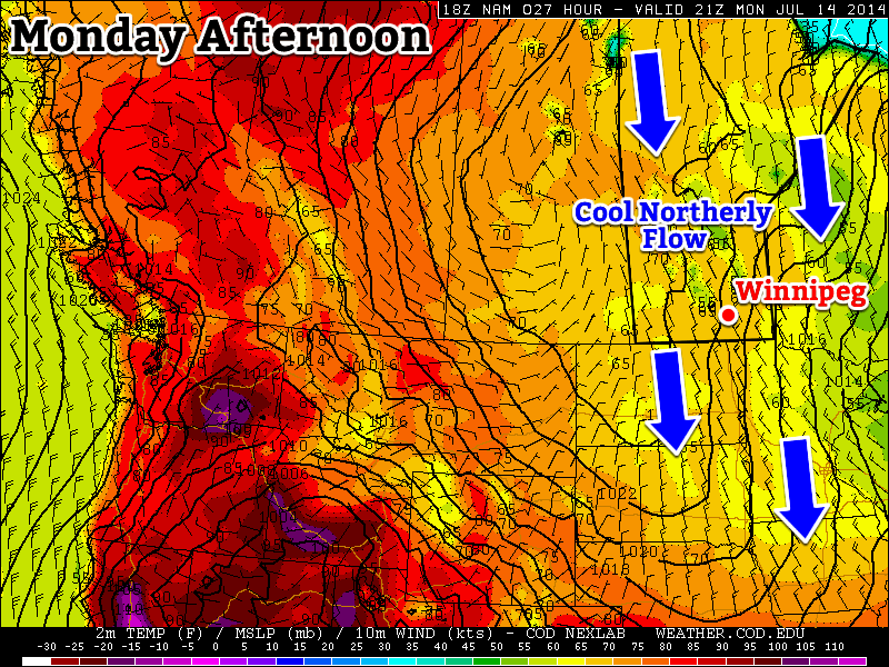
A northerly flow will maintain cool conditions over Manitoba to start the week

Monday

Monday
20°C / 8°C
Mix of Sun and Cloud. Chance of Showers.

Today will be cool, with temperatures remaining well below normal values. High temperatures will be in the upper teens or lower twenties, with a breezy north-west wind. We may also see some light shower activity during the day as pop-up showers develop with daytime heating.

Tuesday

Tuesday
21°C / 9°C
Mix of Sun and Cloud

Tuesday will be a pleasant day, but it will still be on the cool side. Temperatures will be in the low twenties and winds will be relatively light. Some convective cloud cover will develop by the afternoon, and perhaps a stray shower here and there as well, but it won’t amount to anything of significance.

Wednesday

Wednesday
24°C / 11°C
Mainly Sunny

Wednesday will see temperatures recover further, with values in the low to mid twenties. Cloud cover should be less than earlier in the week and winds will remain light.

Long Range

The long range forecast is looking more summer like. Some models suggest we’ll see temperatures climb into the thirties either late this week or on the weekend. As temperatures begin to climb, the humidity likely will as well. That additional humidity means that the thunderstorm risk will begin to increase again. It’s too early to say if we’re looking at more severe storms, but that potential is usually present under humid conditions.

Cooling Trend Brings More Unsettled Weather

The system that brought severe thunderstorms to the Interlake and southwestern Manitoba will bring a huge shift in the weather pattern over the next couple days as it moves over Hudson Bay and stalls, setting up an extremely abnormal pattern for July that will see cool Arctic air spilling southwards unhindered. In the process another cold front will slump through Southern Manitoba bringing another day of unsettled weather on Saturday.

Friday
25°C / 15°C
Becoming mainly sunny.

Saturday
26°C / 11°C
Showers or thunderstorms likely.

Sunday
19°C / 9°C
Mainly cloudy.

Today will be a fairly nice day all things considered. Winds will be out of the west to northwest at 20-30km/h as temperatures climb into the mid-20’s. No precipitation is expected today. Temperatures will remain somewhat mild tonight, dropping only into the mid-teens.

The RDPS, among other models, is forecasting widespread shower activity in Southern Manitoba on Saturday.

Saturday will bring another bout of unsettled weather as a cold front slumps southward through the Interlake into the Red River Valley. Instability will build throughout the morning with showers and thunderstorms developing along the cold front by midday through the Interlake. The activity will slump southwards through the day, with showers and thunderstorms likely through the Red River Valley, particularly the northern & eastern halves.

Saturday is also the Morden triathlon. Conditions will be fairly pleasant, with temperatures around 15°C in early in the morning warming to around 24°C by lunch time. Winds will start the morning out of the southwest at around 15km/h and increase to 30km/h or so by midday. There will be a very slight chance of a shower beginning late in the morning and through the early afternoon, although precipitation is most likely to hold off until the cold front passes through the region late in the afternoon.

Sunday will mark our first day in a very unseasonably cold air mass. Most of Southern Manitoba will see a northwesterly wind at 30-40km/h. The high will only be around 19°C – some 7 or 8°C below normal. There will be a chance of showers on Sunday night while temperatures dip below the 10°C mark.

How Long Will The Cold Last?

The CPC is forecasting a 100% chance of below-normal temperatures for the Eastern US in the 6-10 day range.

There’s no question the incoming cold air is hugely abnormal for this time of year: 1000-500mb thicknesses[1] are expected to fall below 546dm through Northwestern Ontario into MN/WI/MI. These values are more appropriate for late in the fall than in the middle of July. Depending on exactly how deep this cold trough becomes, record low thicknesses for July may be set in those regions.

Here in Manitoba, we’ll avoid the core of the coldest air, but we’ll still be well below normal. Fortunately this setup doesn’t appear to want to remain locked in for very long. The cold trough is expected to push off to the east fairly quickly with warm air pushing back into the province by mid-week.

As the warm air pushes in, it actually looks like we may finally move into a warm and dry summer-like pattern. All long-range weather models are showing a nice dry spell developing from mid-week into next, with temperatures gradually warming up towards the 30°C by the end of the week!


  1. The 1000-500mb thickness is literally the distance between those two levels in the atmosphere. The colder the column of air is, the lower the thickness while the warmer the column is, the higher the thickness is.  ↩