Quiet Weather Ahead

Aside from a couple chances of some scattered showers, fairly seasonal weather lies ahead for the Red River Valley through the second half of the week.

Wednesday

13°C / 2°C
Increasing cloud in the morning. Tiny chance of scattered showers late in the day.
Thursday

9°C / -1°C
A mix of sun and cloud.
Friday

10°C / 0°C
A mix of sun and cloud; chance of afternoon/evening showers.

We’ll see a fairly pleasant day today with temperatures climbing just above seasonal to around 13°C with light winds. Some cloudiness will push in through the day as a cold front pushes towards the Red River Valley. There will be a slight chance of scattered showers along the cold front; any that do develop will be fairly weak and quick-moving. The chance for any one location to see a shower is fairly low, so expect a rather hit or miss pattern if any showers manage to develop along the front. Winds will shift to the NW behind the cold front with partly cloudy skies. Temperatures will drop to around –1°C overnight.

Thursday will be a quiet day with light westerly winds and a high around 9–10°C. We’ll see a mix of sun and cloud and fairly uneventful weather. The overnight low on Thursday night will drop to around –2°C.

On Friday, we’ll see a mix of sun and cloud with a chance of afternoon or evening showers as a second disturbance slumps southwards through the interlake drawing another push of cold air with it. The chance for any precipitation looks significantly better than it does for today, but if we do see shower activity total rainfall amounts anywhere in the Red River Valley only be a couple mm at most. Cooler air will continue to filter southwards through the night with enough instability building to likely produce some lake-effect showers or drizzle in the lee of the lakes. While it will depend very much on the exact wind direction, at this point it looks like Winnipeg may see some of the lake-effect activity since winds are expected to be roughly from the NNW (~ 20°), which would bring cloud and any precipitation from the south basin of Lake Winnipeg into the city. We’ll keep an eye on that as we get closer to the event.

The Weekend Ahead

A fairly benign weekend seems to be in store with little notable weather occurring. Highs look to be slightly cooler than normal in the 7–9°C range with afternoon clouds. No precipitation is expected at this time. Also of note is that now that we’ve passed the Thanksgiving long weekend, frost will no longer be mentioned in Environment Canada forecasts for the Prairies. If you haven’t seen frost yet, consider yourself lucky.

So all in all we have some typical fall weather ahead. Enjoy!
Feeling More Like October

This week will feel more like October as temperatures return to more normal values.

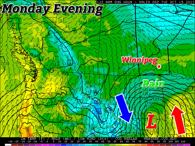
A Colorado Low Will Pass to our South on Monday

Today

Monday

Mainly Cloudy
9°C / 4°C

Another Colorado Low system has made its way onto the American Plains today and just like the last one, it will mainly miss Southern Manitoba. Border regions may see a bit of rain from this system, but in general it won’t be much of a factor in our weather. It will keep skies on the cloudy side though, with mainly cloudy conditions expected in most of Southern Manitoba through the day.

Tuesday and Wednesday

Tuesday

Mainly Sunny
10°C / 0°C
Wednesday

Mainly cloudy. Chance of Showers.
12°C / 2°C

The Colorado Low will have departed the region by Tuesday, leaving behind sunny skies and seasonal temperatures. The wind will be from the north, but it won’t be terribly strong.

Wednesday may see a bit more rain in Southern Manitoba, as a weak system swings down from the north. Temperatures will be in the
low teens, with more cloud than sun.

Long Range

In the long range models suggest that seasonal to below-seasonal weather will dominate. Based on current forecasts, we’ll likely see some light flurry activity before the month is out, but luckily no major snowstorms are currently in the forecast!

Warm Week Ahead with an Unsettled End

Unseasonably warm weather will settle in over Southern Manitoba over the next few days with daytime highs soaring 7–8°C above the normal 12°C for this time of year. Week’s end will bring unsettled weather into the province as a low pressure system lifts northwards out of the Central Plains of the United States.

Wednesday

19°C / 7°C
Mainly sunny with a few cloudy periods in the afternoon.
Thursday

19°C / 12°C
Increasing cloud through the day. Chance of showers in the evening.
Friday

18°C / 8°C
Cloudy. A few showers likely.

Today & Tomorrow

We’ll see a very pleasant day today with a high around 20°C and bright sunny skies light winds out of the southwest. We may see a little afternoon cloud, but nothing too significant. Tonight will be a fairly seasonable night with mostly clear skies and a low near 7°C.

Tomorrow will start off mostly sunny, but we’ll see some scattered cloud through the day and by late in the day we’ll start to see more organized cloud cover starting to push into the Red River Valley from North Dakota. There will be a slight chance of a shower through the evening hours as a warm front lifts north through the Red River Valley & Interlake regions but no significant accumulations are expected in our region.

An Unsettled Friday

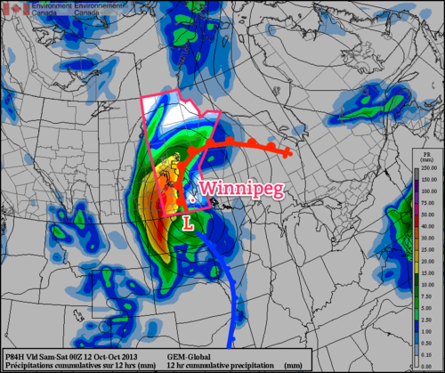
Friday will most likely end up a somewhat unsettled day as a low pressure system tracks through the Red River Valley. This disturbance will bring a fair amount of rain to Western Manitoba; at this point it looks like close to 40–50mm will fall near the Saskatchewan border. Here in the Red River Valley rainfall will be lighter and more disorganized in nature. We’ll see a decent chance of some light scattered showers through the Red River Valley through the day under cloudy skies. The temperature should climb to around 18°C as we sit just on the warm side of the main frontal boundary of this system.

12hr. QPF valid Fri. 12Z - Sat 00Z w/Frontal Analysis

Forecast rainfall through the daytime on Friday from the GDPS. Rainfall accumulation 12Z – 00Z; low position & fronts valid for Saturday 00Z.

We’ll likely see the bulk of the rain we receive on Friday night and Saturday as we move onto the back-side of the system and a large area of wrap-around precipitation hangs back over the Red River Valley. At the moment, models are forecasting total accumulations around Winnipeg to be anywhere from 5–15mm by the end of Saturday. Until then, we have a couple nice days ahead so get out there and enjoy them!

October Won’t Have a Scary Start

October won’t start off with any scary weather, but I can guarantee the month will end on a frightening note!

Tuesday Will be a Very Windy Day in Southern Manitoba

Monday

Monday

Mix of Sun and Cloud. Chance of Showers Late.
22°C / 8°C

Today will be a nice day in Southern Manitoba. Temperatures will be in the low twenties, under a mix of sun and cloud. The wind will be breezy and from the south-west. A cold front will push through Southern Manitoba on Monday night, setting up a cooler Tuesday. There may also be some light rain showers associated with this front, but it will be a hit and miss type of rain event.

Tuesday and Wednesday

Tuesday

Increasing Cloudiness
17°C / 4°C
Wednesday

Mix of Sun and Cloud
15°C / 6°C

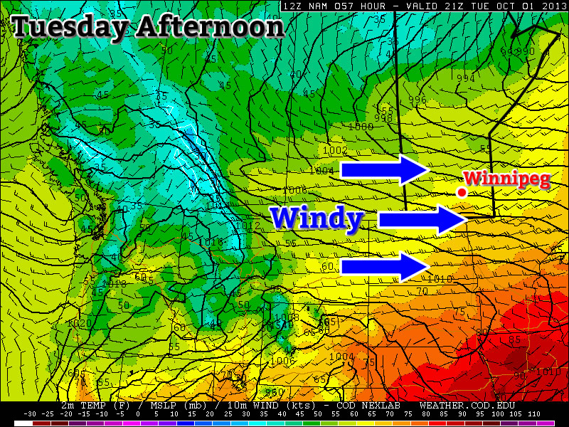
The first day of October will neither be really good, nor really bad. On the one hand it will be a seasonably warm day, with temperatures in the mid to upper teens. However, it will also be a very windy day, with westerly winds of 40-50km/h gusting to 60-70km/h (winds may reach 60km/h gusting to 80km/h on a localized basis). Unfortunately, that strong wind will make conditions much less pleasant than they otherwise would be.

Wednesday looks to be much less windy than Tuesday, but it will still be on the breezy side. Temperatures will be in the mid teens, with a westerly wind of 20-30km/h gusting to 40-50km/h.

Long Range

The long range forecast is looking more October-like. Another cold front is currently forecast to move through Manitoba on Wednesday night, bringing in cooler conditions to end the week. Models are also hinting at a strong low pressure system passing near or just south of Manitoba later this week. Should this system take a more northern track, it could impact Southern Manitoba…but it’s too early to say.