A series of slow-moving low pressure systems will continue to bring cool conditions and periods of wet weather to southern Manitoba.
We’re back from our break over the long weekend and, well, we hope you enjoyed the beautiful Thanksgiving weather. Now a distant memory, a series of low pressure systems are bringing much colder weather to the region.
A band of lake-effect precipitation from Lake Winnipeg will shift across the region today as winds shift to the north. This will bring a chance of flurries or showers to Winnipeg through the morning. Skies will stay cloudy most of the day, but the chance for any more precipitation should diminish into the afternoon. Temperatures will climb into the mid-single digits with easing winds.
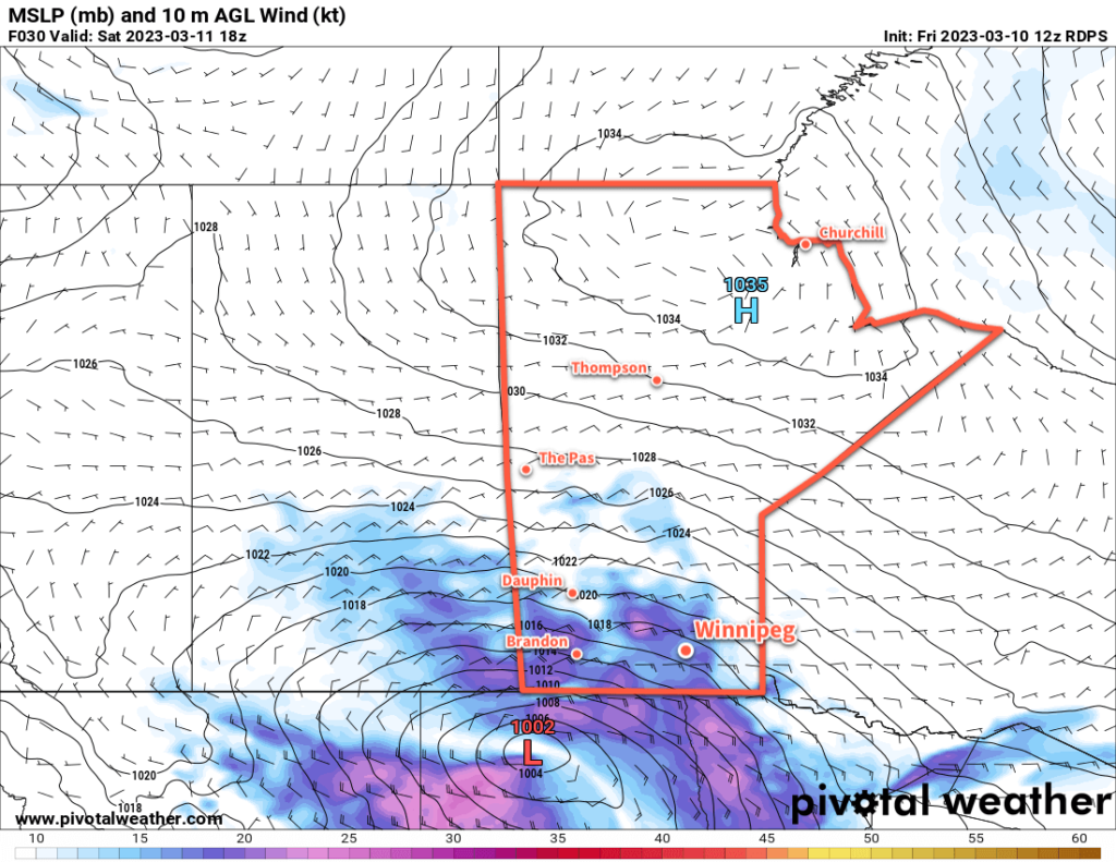
The reprieve will be short lived, though. Another low pressure system will begin dropping southwards into central Manitoba tonight, spreading more rain southwards for Saturday. Most of the precipitation will fall east of Winnipeg, but the city will see a chance of seeing some rain. If the main area of rain from the system doesn’t affect the city, lake-effect squalls developing it its wake could. Temperatures will be warmer on Saturday with a high of 7 or 8 °C even though skies stay cloudy. Northwest winds of 20 to 30 km/h will persist through the day.
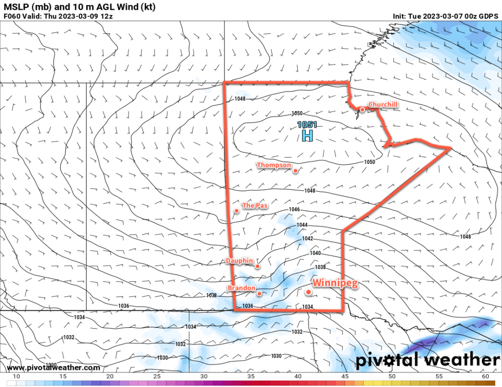
This entire complex of systems will finally begin to shift out of the region on Sunday. Unfortunately, that will also come with an Arctic high pushing into the region. Moderate northwest winds ahead of the high will usher cooler air into the region on Sunday, keeping daytime highs in the low single digits. The cloud cover will gradually break up, allowing temperatures to fall well below freezing on Sunday night.
Long Range Outlook
The cool weather will continue on Monday with highs in the low single digits, but the winds will be much lighter. Cool conditions will continue for Tuesday, then a return to more seasonal temperatures will arrive midweek. Drier weather should also return with the seasonal temperatures.
Today’s seasonal daytime high in Winnipeg is 11 °C while the seasonal overnight low is 0 °C.
Cool weather continues this week with more precipitation in the forecast. Another batch of snow is heading to the province on Wednesday, followed by another winter storm on the weekend.
Yesterday’s sunshine will be gone today as more cloud builds into the region. Warmer air moving in aloft will bring the cloud, but the southeasterly wind will keep it cooler near the ground. Winnipeg will see a high just above freezing today.
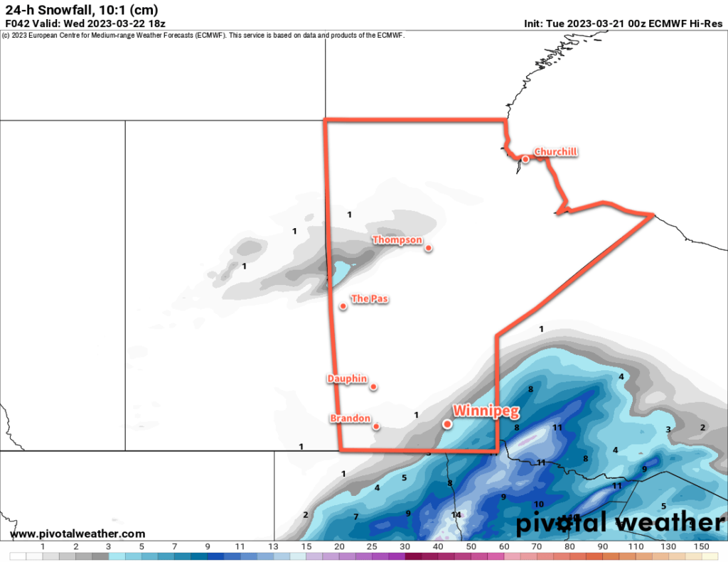
Some light snow will push into the region tonight ahead of the warm front. The snow should start sometime after 7PM and continue into the overnight period. Winnipeg should see around 2–4 cm by Wednesday morning with lesser amounts to the south. Lows will stay mild with the approach of warmer air; Winnipeg should dip to around 0 °C overnight.
On Wednesday morning, a second area of snow will blossom along the cold front and upper jet in North Dakota. This will push into the Red River Valley mid-morning, bringing a second batch of snow to the region. The precipitation should ease later in the afternoon with another 2–5 cm accumulation in the affected areas. The above-freezing temperatures will help compact and melt some of the snowfall as the day goes on. Winds will ease through the day as the low centre moves across the province. Today’s high will reach the low single digits.
Temperatures will dip down to around freezing again on Wednesday night. A few flurries will are likely as well. Northerly winds will pick up into the 30–40 km/h range overnight on the backside of the departing low.
A ridge of high pressure will slide into the province on Thursday, bringing gradually easing winds and some sunny breaks to the region. A high again in the low single digits will continue the below-normal temperature trend in the region. Temperatures will dip to around the freezing mark again on Thursday night with cloudy skies.
Long Range Outlook
Beginning on Friday, the region will start to be affected by a strengthening Colorado Low. While the low centre will stay well south in the United States, precipitation will move into the province already on Friday.
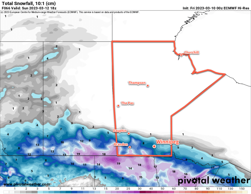
There’s a lot of uncertainty as to what exactly will fall over the province. The Canadian long-range model is trending warmer with most of the precipitation falling as rain. The American models are slightly cooler and trend towards a snow/ice pellet solution. The ECMWF model, on the other hand, sits somewhere in the middle. It has a mainly rain event for the Red River Valley, southern Interlake, and southeast corner of the province. For southwestern Manitoba, the Parkland, and northern Interlake, it produces a mix of ice pellets and snow.
This will be a multi-day system that impacts
the region through Sunday. For areas in western Manitoba, it’s looking like it will be another considerable dump of snow with 20–50 cm possible in some areas. Western Manitoba is also looking like the most likely region to see fairly persistent precipitation through the event. Further east, the precipitation will come in multiple waves separated by relatively benign weather with perhaps a bit of drizzle.
In the waves that do move through, the rain or snow may be quite heavy at times, driven by convective elements. With the snow already on the ground across parts of the region, this could result in rapid snow melt. If you live in a property that has grading issues, you may want to move snow away from your home/foundation before the weekend to help minimize any potential overland flooding risks.
As with the last Colorado Low, this system will also likely see a dry slot wrap into southern Manitoba, most likely for the Red River Valley and areas east. This would result in a 6–12 hour break of benign, mild weather with the only real threat being a bit of drizzle.
As the low pushes off to the east on Sunday, some areas that have only seen rain may see some accumulating snow as well.
We’ll be keeping an eye on this system as it develops through the week and have more details in our Friday forecast!
Today’s seasonal daytime high in Winnipeg is 12 °C while the seasonal overnight low is 0 °C.
The cleanup is underway across many areas of Manitoba that were pummelled with strong winds and 30–60 cm of snow. The weather will mostly co-operate over the coming days with cool temperatures and a bit more snow.
The entire eastern Prairies will see very cool mid-April conditions in the wake of the storm exiting the region.
Lingering light snow will taper off today as the storm continues to wind down over the region. Winds will continue to be breezy out of the northwest at 30 gusting 50 km/h. Most notable today will be the temperatures; they will stay well below seasonal values with a high in Winnipeg near -5 °C. Skies should finally clear out this evening with temperatures heading to a low near -10 °C.
A high pressure system moving into the province will bring clear skies on Saturday. Temperatures will continue to be cool with a high near -5 °C. Lows on Saturday night will fall into the mid-minus teens. Another low pressure system approaching the province will spread cloud cover into the region by Sunday morning.
Winnipeg and area will see cloudy skies on Sunday with light snow moving in for the afternoon and evening. Highs will reach close to 0 °C with southeasterly winds picking up to 30 km/h.
A low pressure system will spread snow along the Trans-Canada Highway corridor on Sunday with 10–15 cm near the international easing to 5–10 cm for many areas south of the Trans-Canada Highway corridor.
This system will spread another swath of snow across southern Manitoba, with 10–15 cm near the international border easing to 5–10 cm for many areas south of the Trans-Canada Highway corridor. The main uncertainty with this system is how far north it will push; relatively sharp changes in snowfall totals will mean small shifts north or south can substantially impact the amount of snow a location will see.
Snow will taper off overnight with the sun repeating for Monday. Daytime highs to start the new week will hover around 0°C.
Long Range Outlook
Temperatures will moderate only slightly next week, partly due to a cooler air mass and partly due to the snow cover across the region. Highs should climb above freezing for next week, but conditions may also turn unsettled.
A progressive system is forecast to move through the region mid-week, potentially bringing another shot of snow to the region. Early model guidance suggests that 10–15 cm is possible with this system, but it’s early and lots can change between now and then. It will likely fall as snow, but there may be a little bit of rain mixed into it.
The region will see a couple quiet days, then for the weekend some weather models are suggesting that another Colorado Low system may develop. This one wouldn’t bring more snow to the region; rather, it would likely result in a surge of warm air northwards and could result in rain for the region. But, being so far out, it shouldn’t be taken as much more than hand-waving conjecture at this point.
As a generalization, beginning Sunday, it looks likely that the region will see some additional precipitation every 2–3 days for a while. By next weekend, the region is more likely to see rain than snow as warmer, almost summer-like, temperatures begin to push towards the region.
Today’s seasonal daytime high in Winnipeg is 10 °C while the seasonal overnight low is -2 °C.
The most significant spring blizzard in decades is bearing down on southern Manitoba, but there’s nuance in the details. What follows is the best interpretation of the upcoming weather we can discern as of the time of writing. The forecast for this system may change on short notice, so be sure to keep alert of any updated forecasts or warnings from official sources.
A complex storm system will bring a major spring blizzard to southern Manitoba beginning later today. While the broad strokes of this system have been quite clear for several days now — a testament to improvements in medium-range weather modelling over the past decade — there are many nuances to this system that will add layers of complexity to the forecast.
A pair of low pressure systems have merged overnight and now exist as a single potent low centred over western Nebraska and Colorado. This system is supported by two distinct features: an upper low over Iowa and a digging upper trough over Utah and Colorado. These two upper features and their evolution will guide the development of this system over the next 36 hours.
As this system pushes eastwards today, it will split into two surface lows: one that lifts northwards through the Dakotas through the day, and another that lingers in Colorado for a while longer before ejecting northeastwards into Minnesota. The northern low will be supported by the upper low, while the southern low will move along with the upper trough and strong frontal wave.
The first wave of snow will move into southern Manitoba this evening, supported by the northern low pressure system. This snow will likely be quite heavy with snowfall rates reaching as high as 3–5 cm/hr. This first shot of snow will lift from North Dakota into SE Saskatchewan and SW Manitoba, then spread eastwards across the Red River Valley and into NW Ontario. By the end of Wednesday, it’s likely that 20–40 cm of snow will have fallen over the southwestern corner of the province and the western escarpment/Riding Mountains, and 10–20 cm of snow in the Red River Valley and southeast corner of the province.
As the day progresses on Wednesday, the precipitation lifts northwards as the northerly surface low stalls out near the MB/ND/MN borders. It looks quite likely that this system’s dry slot will spread into southern Manitoba, bringing an end to most of the snow over the Red River Valley and southeastern Manitoba. If this happens, the region would see a reprieve from the snow later Wednesday through the night, but with a decent chance of [freezing] drizzle or few flurries through that period. The snow will continue elsewhere in Manitoba, albeit comparatively lightly with general accumulations overnight of 5–10 cm. Terrain features will continue to see enhanced accumulations with 10–20 cm possible, particularly closer to Lake Manitoba and the Riding Mountains.
On Thursday, the Colorado Low will become dominant in NW Ontario, producing heavy snow that will spread westwards across the Interlake into western Manitoba through the day. Light to moderate snow will spread back through the Red River Valley for Thursday. The stalled surface low in Manitoba will collapse as the Ontario low strengthens, and the strongest winds will shift eastwards into the Red River Valley with sustained northerlies of 50–60 km/h. Close to 5 more centimetres of snow is likely for Winnipeg on Thursday.
The snow will begin to ease on Thursday night, then clear out of the region through Friday.
Regarding the wind and blowing snow, the stalling of the low near the MB/ND/MN border and timing of the NW Ontario low takeover will result in full-fledged blizzard conditions being most likely in SE Saskatchewan into SW Manitoba. Lighter winds are likely in the Red River Valley, and the peak forecast winds for this system have subdued slightly. That said, especially in the first wave, white-out conditions will be possible in heavy snow.
So, by the time the snow tapers off on Friday, it still look likely that 30 to 50 cm of snow will fall widespread across southern Manitoba. It will be a fairly persistent event from areas in SE Saskatchewan through southwest and western Manitoba as well across the Interlake. It looks like the situation in the Red River Valley will be different though, with multiple waves of snow. Winnipeg and area will likely see a wave of very heavy snow on Wednesday morning taper off later in the day with as much as 15–25 cm possible. Snow will likely ease for the city Wednesday evening/overnight with a chance of [freezing] drizzle. The wind will pick up on Thursday as more snow moves back into the region; the Winnipeg area will likely could see as much as 5–10 cm of snow.
Lighter amounts will fall to the south, but a heavier band of snow the north will give 10+ centimetres to the Interlake and other parts of central Manitoba.
The snow, wind, and blowing snow will begin to ease Thursday night, with conditions continuing to improve on Friday. For Winnipeg, this means that about half of the expected snow will likely fall on Wednesday alone, with the other half or so coming over the following 24–36 hours as a separate wave of snow. It will still amount to quite a bit, but it won’t be the 3-day raging blizzard like it looked like it could be even a day ago.
Temperatures will hover just above freezing today and tomorrow, then fall below freezing on Thursday.
Long Range Outlook
Cooler temperatures will stick around for the weekend with sub-freezing highs and seasonably cool lows. It should be a relatively quiet period for several days after this event, giving plenty of time to clean up after this storm.
Today’s seasonal daytime high in Winnipeg is 9 °C while the seasonal overnight low is -3 °C.