A Few Flurries Usher in Cooler Weather

The Winnipeg area will see mixed skies with some occasional light snow over the coming days as cooler weather slumps into the region.

RDPS 10m Wind Forecast valid 00Z Wednesday November 30, 2022
Moderate to strong northwesterly winds will begin to usher in a colder air mass later today.

Cooler temperatures will filter southwards into Manitoba this week behind a departing low pressure system. This low will track from the Interlake eastwards into Ontario today with strengthening northerly winds developing in its wake. In Winnipeg, northwest winds will strengthen up to 40 gusting 60 km/h by the evening as skies cloud over. Once the cloud moves in, flurries will be likely across the region, and there may be some localized blowing snow in the area by evening. Temperatures will reach a high near -3 °C today, then dip down below -10 °C overnight tonight.

On Wednesday, the wind and flurries will taper off through the day, but the clouds might not break up until later in the afternoon. Temperatures will be much cooler with a high near -9 °C. With some clear breaks overnight, temperatures will fall into the mid-minus teens for a low overnight.

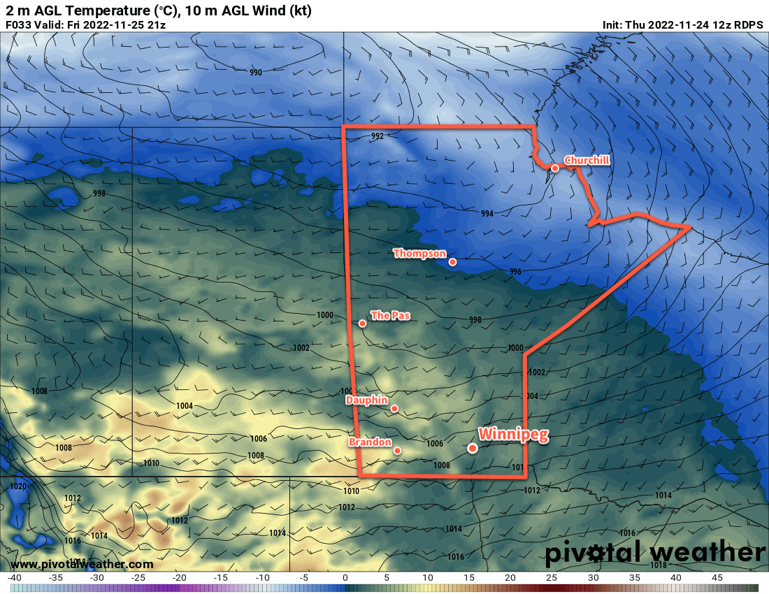
On Thursday, another low pressure system will begin approaching from the west, spreading more cloud cover into the region. Winds will pick up out of the south to around 30 km/h with highs a tad warmer, closer to -7 °C or so. With the thickening cloud cover, temperatures will stay a bit warmer on Thursday night, only dipping to around -10 °C. This approaching low will spread snow into southern Manitoba with the first flakes likely falling by early Friday morning.

Long Range Outlook

Snow will taper off later Friday with northerly winds picking up through the day. The region could see anywhere from 2–5 cm of snow, and temperatures will fall into the minus teens by the end of the day.

The cloud cover will break up on Friday night as a colder air mass moves into the region. Beginning on the weekend, daytime highs will dip below -10 °C while overnight lows head toward the -20s, bringing the first real shot of winter cold to southern Manitoba. While there will be some ups and downs, temperatures look like they’ll continue to drop next week with daytime highs possibly falling into the low minus teens by midweek.

Today’s seasonal daytime high in Winnipeg is -6 °C while the seasonal overnight low is -15 °C.

Mild Weather Continues Into the Weekend

Beautiful late-November weather will continue in Winnipeg for a few more days with daytime highs climbing above freezing.

RDPS 2m Temperature Forecast valid 21Z Friday November 25, 2022
The southern Prairies will see very mild daytime highs on Friday, though existing snow pack could limit some of the warmest temperatures if the winds can’t mix out all of the cool air near the snow-covered surface.

An upper ridge over the Prairies continues to bring seasonably mild temperatures to the region. Across southern Manitoba, daytime highs climbed above freezing yesterday and will stay there for another couple days yet. With Pacific air continuing to wash over the Prairies, daytime highs in Winnipeg will climb above 0 °C into the low single digits both today and tomorrow.

The wind strengthen out of south-southwest today to around 30 km/h and then ease tonight. A weak cold front will go through, bringing some cloud overnight, and then the winds will pick up out of the northwest Saturday into the 20 to 30 km/h range.

The pattern across the Prairies will begin to change on Sunday as the upper ridge collapses and a low pressure system begins to drop southeastwards across the Prairies. As it approaches, the wind will pick back up out of the southeast through the Red River Valley, but the warmer air will have slumped a bit south and more cloud will build into the region. Temperatures climb to a high near freezing, but with cloud building through the day and breezy southeasterlies, it will feel much cooler than the prior days.

As the low pushes into the region on Sunday night, light snow will blossom across the region.

Long Range Outlook

A bit of a complex setup will develop next week as energy collapses southwards from the low over southern Manitoba to a developing Colorado Low. While the Colorado Low will likely impact Ontario, the interaction of these two systems could support some periods of light snow across the region for a couple days.

By the middle of next week, cooler temperatures will begin slumping into the Prairies, sending daytime highs down below -10 °C with overnight lows dipping into the low teens.

Today’s seasonal daytime high in Winnipeg is -5 °C while the seasonal overnight low is -13 °C.

Cooler Weather Ahead With A Chance of Snow

Winnipeg’s temperatures will continue to slide over the next week as multiple disturbances move through the region.

RDPS 2m Temperature Forecast valid 00Z Wednesday November 9, 2022
Tuesday afternoon will likely be the last time Winnipeg sees above-freezing temperatures for…a while.

More snow is on the way today, but it will fall to the west and north of Winnipeg. Although Winnipeg got a bit of snow overnight, the main bulk of the snow pushed into western Manitoba overnight. It will continue to the northeast today, while here in the Red River Valley temperatures warm slightly under cloudy skies.

Winnipeg will see a high up to around the 5 °C mark this afternoon with easing southeasterly winds. Skies will stay cloudy through the day. A trough will move through this afternoon, followed by a cold front in the evening. The trough will bring a chance of showers as it moves through this afternoon. Cloudy skies will continue this evening with the passage of the cold front. It doesn’t look like any snow will fall with that frontal passage.

Heading into the rest of the week, Winnipeg will find itself on the edges of passing systems. Disturbances will push past the area on Wednesday afternoon and later on Thursday, but both will mainly affect areas southeast of Winnipeg. Wednesday’s system will bring a chance for some afternoon flurries, but Thursday’s could bring more notable snowfall. Right now, it appears that Winnipeg will only be grazed by the system with 2—5 cm accumulation by Friday morning. Amounts will increase southeast of the city, with 15 to 25 cm likely over the southeast corner of the province. Coupled with strengthening north winds, travel conditions to the south and east will likely deteriorate Thursday night into Friday with accumulating snow and blowing snow.

Snowfall accumulations will be sensitive to the track of this system. Should it push northwest a little bit, Winnipeg may be seeing a more significant snowfall event to end the week.

Through this whole time, cooler and cooler temperatures will be pushing into Winnipeg. Today’s above-freezing high will give way to a high near 0 °C on Wednesday that then drops towards -5 °C for the rest of the week. Overnight lows will also drop below -10 °C by the end of the week.

Long Range Outlook

Heading into next week, a strong northwesterly flow will develop aloft, allowing Arctic air to spill southwards across the Prairies. This will lead to a prolonged period of below-normal temperatures with highs likely in the mid-minus single digits and overnight lows near or below -10 °C. The region should see a bit of sun through the weekend, but cloudier conditions will return next week. Multiple disturbances will slump southwards in the flow, bringing several chances for snow next week. In addition, the colder air moving into the region will combine with the organizing northwest winds and will likely produce some lake-effect snow in the lee of the Manitoba Lakes next week.

It’s been a nice run, but it does indeed look like the region is finally on its decent out of fall into winter. Get those long johns and snow pants ready!

Today’s seasonal daytime high in Winnipeg is +1 °C while the seasonal overnight low is -7 °C.

Seasonably Cool and Wet Weather Continues

A series of slow-moving low pressure systems will continue to bring cool conditions and periods of wet weather to southern Manitoba.

RDPS 2m Temperature Forecast valid 21Z Saturday October 15, 2022
A persistent northwesterly wind over the next few days will continue to funnel cool, Arctic air southwards over Manitoba.

We’re back from our break over the long weekend and, well, we hope you enjoyed the beautiful Thanksgiving weather. Now a distant memory, a series of low pressure systems are bringing much colder weather to the region.

A band of lake-effect precipitation from Lake Winnipeg will shift across the region today as winds shift to the north. This will bring a chance of flurries or showers to Winnipeg through the morning. Skies will stay cloudy most of the day, but the chance for any more precipitation should diminish into the afternoon. Temperatures will climb into the mid-single digits with easing winds.

The reprieve will be short lived, though. Another low pressure system will begin dropping southwards into central Manitoba tonight, spreading more rain southwards for Saturday. Most of the precipitation will fall east of Winnipeg, but the city will see a chance of seeing some rain. If the main area of rain from the system doesn’t affect the city, lake-effect squalls developing it its wake could. Temperatures will be warmer on Saturday with a high of 7 or 8 °C even though skies stay cloudy. Northwest winds of 20 to 30 km/h will persist through the day.

This entire complex of systems will finally begin to shift out of the region on Sunday. Unfortunately, that will also come with an Arctic high pushing into the region. Moderate northwest winds ahead of the high will usher cooler air into the region on Sunday, keeping daytime highs in the low single digits. The cloud cover will gradually break up, allowing temperatures to fall well below freezing on Sunday night.

Long Range Outlook

The cool weather will continue on Monday with highs in the low single digits, but the winds will be much lighter. Cool conditions will continue for Tuesday, then a return to more seasonal temperatures will arrive midweek. Drier weather should also return with the seasonal temperatures.

Today’s seasonal daytime high in Winnipeg is 11 °C while the seasonal overnight low is 0 °C.