A Blustery Storm Ushers In Colder Conditions

One more warm day, then a blustery storm system moving through will shift Winnipeg into a cooler weather pattern.

A low pressure system moving into the province tonight will usher in a change for Winnipeg’s general weather pattern. Today will still be mild with temperatures climbing up to around -1 °C with mixed skies becoming cloudy this evening. The wind will be a little more noticeable today, picking up out of the south into the 20–30 km/h range for the afternoon and evening.

The low will arrive this evening, bringing warm air that will send temperatures up above 0 °C overnight. There will be a chance for a wintery mix overnight (snow, freezing rain, rain), but what exactly falls is highly dependent on the track of the low and how warm it ends up being. The temperature will drop below freezing to around -1 °C by Thursday morning.

RDPS Precipitation Type/Rate Forecast valid 09Z Thursday January 14, 2021
A low pressure system crossing the province will bring a wintery mix to the region on Wednesday night, followed by snow on Thursday.

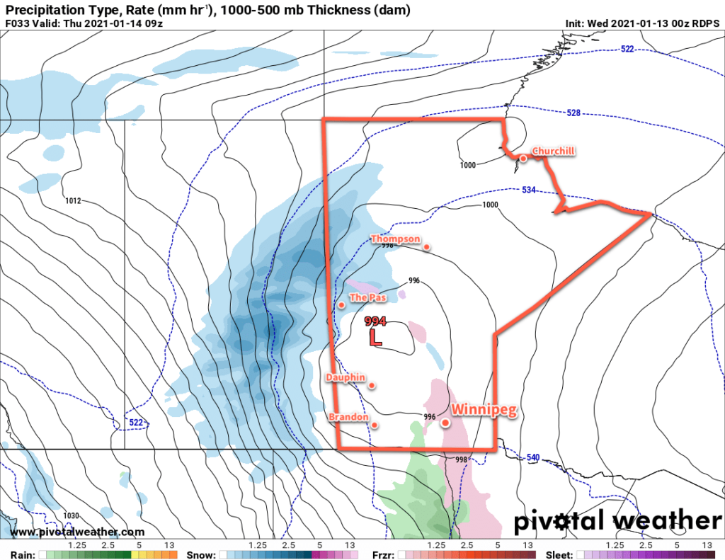
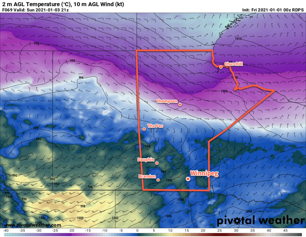
Moderate northwest winds will move in on Thursday, strengthening to 30–40 km/h with gusts up to 60 km/h. Much of the region will see periods of light snow with widespread accumulations of 2–4 cm. A cold front passing through on Thursday night will reinforce the winds and bring more light snow to the region. This snow and wind will likely produce some areas of poor visibility in blowing snow on Thursday night. Temperatures will head to a low near -8 °C.

By Friday, it’s all cold air advection. Temperatures will struggle to move much from their starting point in the morning as the moderate northwest winds continue. Temperatures will only climb a degree or two above the day’s starting point for a high near -7 °C. The snow should taper off through the day, but skies will stay cloudy. The winds will ease Friday night with temperatures heading to a low near -13 °C under mostly cloudy skies.

Long Range Outlook

Cooler temperatures will persist right through next week with daytime highs generally in the -5 to -10 °C range and overnight lows dipping into the minus teens. Skies will stay on the cloudier side, and with the expected temperatures there will be a chance for some non-accumulating light snow on many days.

By the end of next week, it looks increasingly like the polar vortex will shift southwards and begin to flood central and eastern Canada with much colder polar air. This will likely mark the start of an extended period of generally below-seasonal temperatures with the potential for outbreaks of extreme cold.

Winter had to arrive at some point…enjoy the pleasant conditions while they last!

Today’s seasonal daytime high in Winnipeg is -13 °C while the seasonal overnight low is -24 °C.

Missing: Typical Winter Cold

Winnipeg will continue to see temperatures well above seasonal values this weekend. The deep freeze typical for this time of year looks to stay absent through the coming week.

Instead of the cold, Winnipeg will instead see temperatures climb towards freezing over the coming days as a series of low pressure systems moving across the Prairies spread mild Pacific air into the region. First, though, Winnipeg will see a high near -8 °C today. Skies will likely stay cloudy for much of the day with plenty of stratus left behind from a disturbance that moved through overnight. With the cloud, the city will also likely see some light snow through the day. Clearing should work into the region this afternoon, though there’s a chance it could take until evening for it to reach Winnipeg. Once it clears out, Winnipeg will see mainly clear skies overnight with a low near -12 °C.

On Saturday, the first of two low pressure systems will work across the central Prairies into Manitoba. As it pushes eastwards, it will spread cloud into the region through the afternoon hours. Winds will start light, but strengthen out of the south into the 30–40 km/h range for the afternoon. Temperatures will climb to a high near -2 °C. More cloud will move through the region on Saturday night as the winds ease and temperatures hover around -1 °C.

RDPS 2m Temperature Forecast valid 21Z Sunday January 3, 2021
Mild temperatures close to 0 °C will move into Manitoba this weekend. Temperatures may even be a few degrees above zero in the downslope winds of the Red River Valley’s western escarpment.

On Sunday, another low — slightly stronger than the first — will scoot across the Prairies. Temperatures will climb to around 0 °C in Winnipeg with skies clouding over. Winds will be light to start and gradually pick up to around 30 km/h in the afternoon. Heading into the night, a trough moving through the Red River Valley may bring some light snow or even a couple rain showers, depending on where exactly the temperature is at the time. Temperatures will dip to a low near -2 °C by Monday morning.

Long Range Outlook

Temperatures will cool slightly next week with highs slumping into the -5 to 0 °C range. Lows will also follow suit, staying well above normal for this time of year in the -5 to -15 °C range. Some snow is possible with a cold frontal passage on Monday, otherwise while skies stay on the cloudier side there should be little snow to speak of through the rest of the week.

Today’s seasonal daytime high in Winnipeg is -13 °C while the seasonal overnight low is -23 °C.

Winter Storm Brings Bitter Arctic Cold

Hot on the heels of the first significant dump of snow Winnipeg has seen this winter, a winter storm will move through on Tuesday bringing more snow followed by bitter cold.

The lingering snow in Winnipeg will taper off early this morning, bringing an end to the first significant snowfall of the season. Between 10 and 15 cm of snow fell across the city overnight. The city will see cloudy skies through the day with temperatures climbing to a high near -8 °C. The brisk northerly winds in place this morning will taper off for the afternoon. The cloud cover should push off to the east tonight, leaving partly cloudy skies as temperatures head to a low near -13 °C.

Winnipeg’s set to see a notable winter storm beginning Tuesday. A potent clipper system will track across the Prairies, spreading heavy snow along the Trans-Canada corridor in Saskatchewan Monday night and across Manitoba on Tuesday. The snow will begin mid-morning in Winnipeg and continue right through Tuesday night. The city could see up to 20 cm of snow from this storm by Wednesday morning.

RDPS 24-hr. Snow Accumulation Forecast (at 10:1 SLR) valid 09Z Wednesday December 23, 2020
A potent clipper system will spread a swath of 10 to 20 cm of snow along the Trans-Canada Highway corridor Monday night through Tuesday.

While the snow alone will produce inclement conditions through the day, it will get worse heading into the evening. Northerly winds will strengthen into the 30–40 km/h range. Blowing snow will develop across the region and persist through the night into Wednesday morning before tapering off. The combination of snow and blowing snow will likely produce periods of poor visibility on area highways on Tuesday night.

This storm system will push mild temperatures into the region with a high near -3 °C on Tuesday. Behind it, Arctic air will begin surging southwards. The city will see a low near -18 °C by early Wednesday morning.

RDPS 2m Temperature Forecast valid 12Z Thursday December 24, 2020
A bitterly cold Arctic air mass will spur into Manitoba on Wednesday night.

The winds will gradually ease in Winnipeg on Wednesday with clearing skies. Arctic air will continue to push southwards through the day with temperatures falling to -21 °C by the end of the day. Between the cold air pushing into the region and the 20–30 cm of snow likely to be on the ground at the time, temperatures will plummet on Wednesday night to a low near -28 °C with clear skies.

Long Range Outlook

The cold weather will last through Thursday, but by Friday more seasonal temperatures are forecast to return to the region. No significant snow events are in the forecast through the weekend.

Today’s seasonal daytime high in Winnipeg is -11 °C while the seasonal overnight low is -22 °C.

Mild Winter Weather Continues

Temperatures will continue to stay well above seasonal averages as Winnipeg’s mild winter continues.

A series of low pressure systems will move across the province over the coming days, bringing mild temperatures with them. The first one moved into the province overnight, bringing temperatures up to -2 °C with moderate southerly winds. The city will see some light snow first thing this morning as the winds taper off. A cold front will pass later this morning, bringing brisk northwest winds up to 40 gusting 60 km/h as skies clear. These winds will usher in colder air and send temperatures falling through the afternoon to around -10 °C. The winds will drop off this evening with temperatures falling to a low near -19 °C.

On Saturday, the city will see increasing cloudiness with strengthening southerly winds as the next low approaches. Temperatures will climb to a high near -5 °C with southerly winds in the 30–40 km/h range. The winds will ease on Saturday evening with some of the cloud cover breaking up. Temperatures will head to a low near -14 °C with some northwest winds picking up to 30 km/h as a cold front sweeps through. A few flurries will be possible along the cold front as it moves through.

RDPS 2m Temperature Forecast valid 21Z Saturday December 19, 2020
Another surge of mild air will push into Manitoba on Saturday.

Warmer air will once again build back into the region on Sunday as the next low begins developing over Alberta. Skies will cloud over through the day with light snow likely Sunday night as the low moves through. The city will see a seasonably mild high near -4 °C and temperatures steady near -5 °C overnight.

Long Range Outlook

Next week will start off with more mild weather with highs near -5 °C and overnight lows in the -10 to -20 °C range. Some more snow is likely on Tuesday, followed by a potent cold front that will send Arctic air southwards. Winnipeg could see a mid-week cold snap with highs in the -15 to -20 °C range followed by a moderation back to milder conditions for the end fo the week.

Today’s seasonal daytime high in Winnipeg is -11 °C while the seasonal overnight low is -20 °C.