Cool with Snow to Start, But Spring Arrives Mid-Week

Winnipeg will have a cool and unsettled start to the week, but warmer spring conditions are on the way.

A cold front slumping southwards today will bring cool temperatures and mostly cloudy skies to Winnipeg. Northwest winds up to 30 gusting 50 km/h will keep temperatures to a high of just +3°C. A few flurries will be possible midday through the afternoon as general instability develops over the region. The clouds will clear out this evening with diminishing winds. A ridge of high pressure moving through overnight will send lows down to -10°C by Tuesday morning.

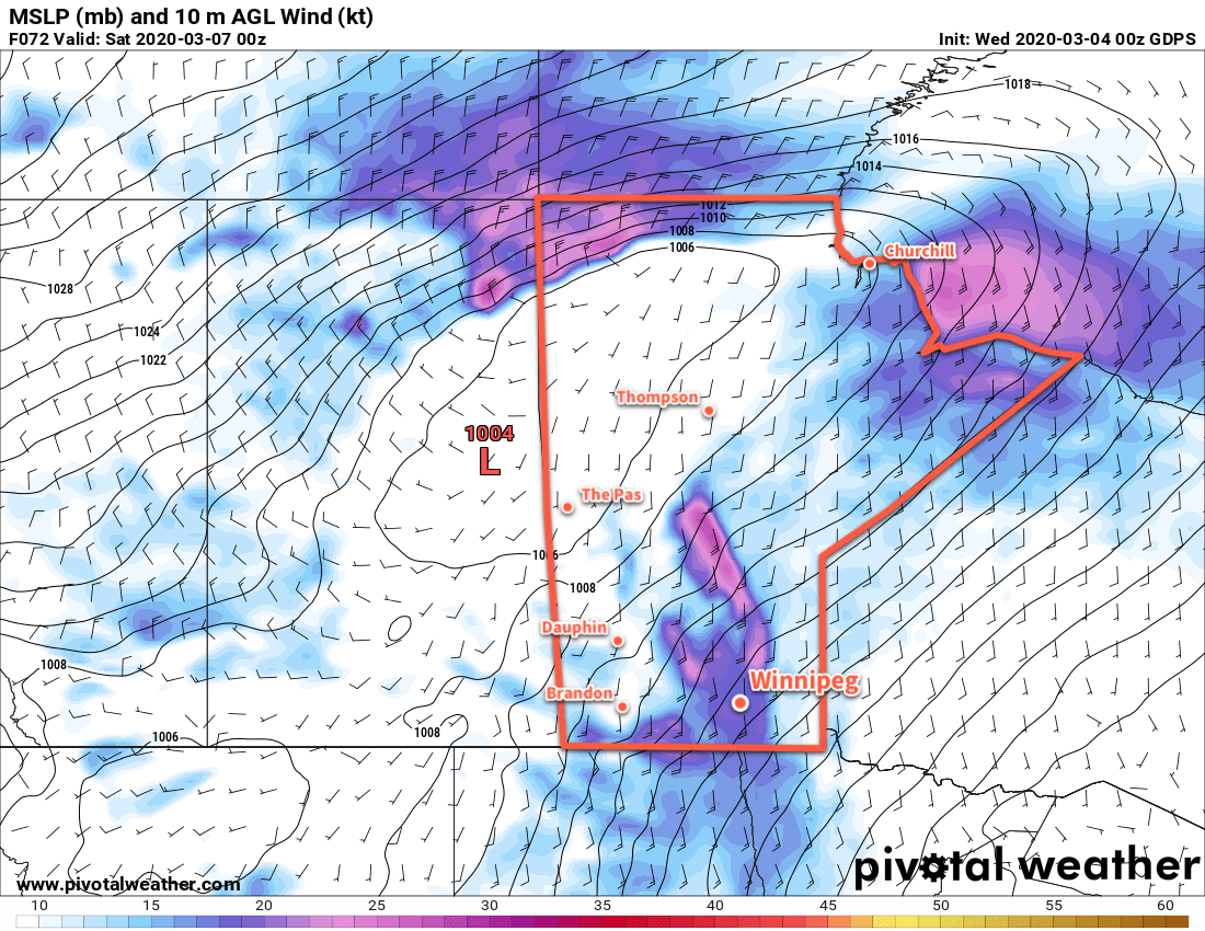
Another low pressure system will slide through the southeastern Prairies on Tuesday. While it will bring mild conditions to southeastern Saskatchewan and southwestern Manitoba, it will be much cooler in the Red River Valley. Highs will again sit near +3°C with breezy south-southeast winds of 30 gusting 50 km/h. Skies will cloud over in the morning as the low pushes into the southwest corner of the province, followed by some light snow through the afternoon hours. The winds will taper off in the evening with some fo the cloud cover breaking up. Temperatures will dip to a low near -2°C.

RDPS Precipitation Type/Rate Forecast valid 06Z Monday April 20, 2020
On Tuesday, a low pressure system will produce a swath of snow that moves from west-central Manitoba southeastwards into the Red River Valley.

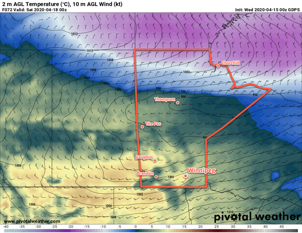
Wednesday will mark the beginning of The Turnaround®. A more zonal flow will develop across the Prairies as the west coast upper ridge begins to collapse, allowing milder Pacific air to push eastwards. Winnipeg will see a high near +9°C with mixed skies and light winds. Skies will stay mixed on Wednesday night with a low near +2°C.

Long Range Outlook

The rest of the week finally looks to bring pleasant spring weather. With partly cloudy to mixed skies, Winnipeg will see several days of highs in the mid-teens with light winds. There may be a chance of showers (or perhaps even thunderstorms) in the second half of the week, currently looking like possibly on Wednesday night into Thursday morning. Even warmer weather looks likely for the weekend with highs climbing into the upper teens.

Today’s seasonal daytime high in Winnipeg is 12°C while the seasonal overnight low is 0°C.

Cool Weather And Flurries Easing Friday

Milder spring weather will return to Winnipeg after a couple more cool days.

A brisk northwest wind of 20 to 30 km/h will keep daytime highs nearly 10°C below normal over the next couple days in Winnipeg. The city will see variable cloudiness today and tomorrow – partly cloudy skies today and mixed skies tomorrow – as the spring sunshine continues to produce convective cloud over the region. The low-level instability in the cool air will continue to bring a chance for some light flurries both days.

Overnight lows will dip into the -5 to -10°C range.

GDPS 2m Temperature Forecast valid 00Z Saturday April 18, 2020
A low pressure system will spread seasonal temperatures eastwards into Manitoba on Friday.

On Friday, a warm front pushing through the province will usher in a milder Pacific air mass. Highs will return towards seasonal values near 10°C with breezy southwest winds of 20 to 30 km/h. Fortunately it’s a fairly dry air mass, so the region should see plenty of sunshine. Near the western escarpement, winds will be a bit stronger with gusts up to 60 km/h.

Long Range Outlook

Winnipeg will see a cloudier weekend with highs in the mid-single digits as a series of disturbances move through. There will be a couple chances for precipitation through the weekend as well. Settled conditions with temperatures rebounding back towards seasonal values will develop early next week.

Today’s seasonal daytime high in Winnipeg is 10°C while the seasonal overnight low is -2°C.

Strong Winds Today, Light Snow and Cooler on Sunday

Winnipeg will see strong southerly winds today as warmer air pushes back towards the region. After a mild Saturday, some light snow and cooler temperatures return for Sunday.

Winnipeg will see windy conditions today as a low pressure system pushes eastwards across the Prairies. Southerly winds will strengthen to 50 gusting 70 km/h this morning and persist through the day. Fortunately, the snow on Wednesday night was fairly sticky and should’t blow around too much. Some areas of blowing snow will be possible in exposed areas outside the city. Temperatures will climb to a high near -1°C and skies will start out on the cloudier side with more sunshine showing through this afternoon. The winds will gradually ease through the night. Temperatures will stay steady around -2°C tonight with increasing cloud.

RDPS 10m Wind Forecast valid 18Z Friday March 6, 2020
Strong southerly winds will develop over the Red River Valley today.

Saturday will bring mostly cloudy skies and light winds to the region. A trough of low pressure will lie across the region, connecting the departing low over Hudson Bay with a developing low over Montana. Temperatures will climb to a high just on the plus side of 0°C. Skies will become overcast on Saturday night with temperatures dropping to a low near -9°C as northerly winds of 20 to 30 km/h develop. Snow will spread into the province through the night; the heaviest snow will track well north of Winnipeg across WestMan into the northern and central Interlake. Here in the city, some light snow is possible heading into the early morning hours of Sunday.

GFS 24hr. Snowfall Accumulation (10:1 SLR) valid Monday March 9, 2020
Snow will spread across portions of central and southern Manitoba on Saturday night through Sunday. Some areas may see 15 to 20 cm of snow by Sunday evening.

A brisk northerly wind of 30 gusting 50 km/h will develop Sunday with temperatures slowly dropping through the day. Skies will stay overcast with periods of light snow likely through the day. By evening, temperatures should be sitting near -9°C. Winds will taper off overnight as temperatures continue to drop to a low near -16°C.

Long Range Outlook

Next week will start with seasonably cool conditions with Monday’s high in the -10 to -15°C range. Warmer weather will quickly return, though, with near-freezing temperatures moving back into the region on Tuesday and sticking around for the week!

Today’s seasonal daytime high in Winnipeg is -4°C while the seasonal overnight low is -14°C.

Mild Week Brings Wednesday Night Snow, Windy Friday

Mild temperatures continue across the Red River Valley, but Winnipeg will see accumulating snow Wednesday evening.

Winnipeg will see temperatures climb to a high near 0°C again today with southeasterly winds increasing to 30 gusting 50 km/h. The city will see variable cloudiness through the morning, then skies will cloud over through the afternoon hours as a low pressure system arrives. Snow will spread into Winnipeg and the northern Red River Valley later this afternoon. Winds will ease in the evening as the low centre moves through, then pick up out of the northwest overnight. By Thursday morning, Winnipeg will see 5 to 10 cm of new snow with northwest winds up to 30 km/h. Temperatures will dip to a low near -5°C tonight. The accumulating snow will taper off overnight.

ECMWF 24 hr. Snowfall Accumulation (10:1 SLR) Forecast valid 18Z Thursday March 5, 2020
A low pressure system moving across southern Manitoba will give 5 to 10 cm (2 to 3.5″) of snow to the region by Thursday morning.

On Thursday, skies will clear out through the day as the low exits the province. Moderate northwesterly winds in the 30 to 40 km/h range will stick around for the day, then ease in the evening. Winnipeg will see a near-seasonal high of -3°C. Mixed skies will develop overnight as winds shift to the south at 10 to 20 km/h. Lows should dip to about -12°C.

On Friday, another low pushing towards the region will generate strong southerly winds in the Red River Valley. Winds will strengthen into the 40 to 50 km/h range by midday as temperatures climb to a high near 0°C.

RDPS 10m Wind Forecast valid 00Z Saturday March 7, 2020
Strong southerly winds will develop over the Red River Valley on Friday.

It looks like Winnipeg will see a fair amount of cloud, but some sunny breaks are likely. The wind will gradually ease on Friday night as temperatures head to a low near -3°C. Skies will stay mostly cloudy through the night.

Long Range Outlook

Mild weather will continue into the weekend with highs at or above freezing on Saturday. A fairly expansive low pressure system will spread snow across the southern Prairies on Saturday, pushing into Manitoba on Saturday night through Sunday. Winnipeg will likely see some snow from this system, but it’s unclear right now exactly how much the city will receive.

Model forecasts suggest that the heaviest snow will be well north of the city, falling from WestMan eastwards across the Interlake and onwards to the Ontario border. If this were the case, Winnipeg would see somewhere around 2 to 5 cm of snow from this system. That said, small changes in the track of this system, north or south, could significantly change the amount of snow the city receives. We’ll take a closer look at this system’s snowfall potential in Friday’s forecast!

Today’s seasonal daytime high in Winnipeg is -4°C while the seasonal overnight low is -15°C.