Snow Tapers off With a Cooler Weekend Ahead

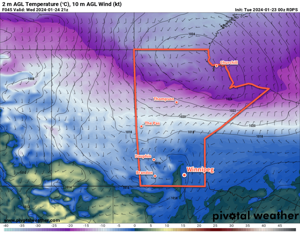
Lingering flurries will taper off across southern Manitoba today as the Colorado Low shifts off to the east. Behind it, northerly winds will diminish as cooler temperatures settle into the region.

RDPS 2m Temperature Forecast valid 15Z Sunday February 11, 2024
Although it won’t be particularly cold for early February, the weekend will bring cooler temperatures than the region has seen recently.

It will be the most wintery day seen in weeks across southern Manitoba today as snow tapers off and the region is left with northerly winds of 30 to 40 km/h. There may be blowing snow in western Manitoba, but the recent warmth and limited new snow in the Red River Valley should prevent it from being much of an issue here. Notable will be how much cooler it will be in Winnipeg than recently. Despite that, temperatures will stay above normal values across the region. Winnipeg’s daytime high should reach around -8 °C today and mainly cloudy skies will keep things mild tonight with a lows dipping into the -15 to -10 °C range.

Saturday will bring mostly cloudy skies to the region as an upper trough swings into Manitoba. Highs will bounce back to around -5 °C with light northwest winds. Temperatures will dip back to around -10 °C on Saturday night under cloudy skies. There will be a chance of light snow overnight as the upper trough moves through the region.

Winnipeg might see sunshine on Sunday as light southwest winds develop across the region. Daytime highs should reach back into the -5 to 0 °C range as warming moves eastwards across the Prairies with a building upper ridge. Temperatures will dip back down into the -10 to -5 °C range on Sunday night with variable cloudiness.

Long Range Outlook

The first half of next week will bring variable cloudiness to southern Manitoba with northerly winds and daytime highs in the -5 to 0 °C range. A cold front will slump into the region in the second half of the week, bringing near-seasonal temperatures as highs slump towards -10 °C along with a chance of flurries.

Today’s seasonal daytime high in Winnipeg is -9 °C while the seasonal overnight low is -20 °C.

Colorado Low Poised to Bring Fresh Snow to Manitoba as Warm Weather Continues

Cloudy skies, mist/fog, drizzle, and mild temperatures will continue for a couple more days in the Winnipeg area. The weather will finally change across southern Manitoba on Wednesday night as a Colorado Low begins to spread waves of precipitation into the province.

ECMWF Precipitation Type Forecast valid 18Z Thursday February 8, 2024.ECMWF Total Accumulated Snowfall Forecast (10:1 SLR) valid 00Z Saturday February 10, 2024.
Waves of mixed precipitation will move into southern Manitoba on Thursday. This Colorado Low will bring accumulating snow to most of southern Manitoba.

The next couple days in Winnipeg will bring more of what the city has seen lately: plenty of cloud, mist and fog patches, and occasional drizzle. A ridge of high pressure moving across the Red River Valley will keep things stagnant with light northerly winds. The trend of temperatures well above normal will continue with highs a couple degrees above freezing and lows right near the freezing point.

Then, the most notable weather system in weeks will begin to impact the region on Wednesday night. As I mentioned in Thursday’s post, long-range models were developing a Colorado Low-like system and pushing it quickly eastwards. I mentioned that I wouldn’t be surprised to see this system pull further west as it approached and…that’s what has happened with the forecast models over the past few days.

A Colorado Low will eject northeastwards on Wednesday, reaching South Dakota by Thursday morning and then into Minnesota by Thursday evening. As it draws closer to Manitoba, it will begin to spread waves of precipitation into the province. The first couple waves, arriving Wednesday night and Thursday morning could bring a wintery mix of snow, rain, and freezing rain to the Red River Valley. As those move off to the northwest, the region will see a break with cloudy skies and a chance of drizzle.

By later Thursday, northerly winds will strengthen across the region and begin to draw cooler air into the region. More snow will be possible Thursday evening through much of Friday before it finally tapers off.

There is a wide range of snowfall accumulations possible with this system, and at this point there is significant uncertainty as to where the axis of heaviest snow will set up in the province. In general, many areas of the province will receive 5 to 10 cm of fresh snow, with 10 to 20 cm possible in the swath of highest accumulation. Amounts could creep even higher on the northern slopes of the Turtle and Riding Mountains where northerly winds enhance the snowfall along the terrain.

With the notable uncertainty that remains with how this system will set up over the province, I recommend you check the updated forecasts on ECCC’s weather website over the coming days.

Daytime highs in Winnipeg will fall into the -5 to 0 °C range by the end of the week with overnight lows in the -20 to -10 °C range depending on how much clearing is able to move into the region.

Long Range Outlook

The weekend will bring cooler — but still above normal — temperatures to the region. Daytime highs will dip to around -5 °C with lows dependent on how cloudy the nights stay. With clearing, lows could drop into the -20 to -15 °C range, but if it stays cloudier then lows could hover near -10 °C.

Hopefully the region will see a bit of sun this weekend, but there’s a chance things do stay on the cloudier side.

Next week will continue the trend with daytime highs near -5 °C and overnight lows in the -10 to -20 °C range as light westerly winds develop over the region.

Today’s seasonal daytime high in Winnipeg is -10 °C while the seasonal overnight low is -21 °C.

Warming up This Week in Winnipeg

It will be a cloudy week in Winnipeg as temperatures climb back towards the freezing mark.

RDPS 2m Temperature Forecast valid 21Z Wednesday January 24, 2024
Warmer temperatures will spread across the southern Prairies this week.

With the Polar Vortex retreating into the High Arctic, a zonal flow will develop across the Prairies this week. Mild Pacific air will spread across the region, sending daytime highs climbing back to near- or above-freezing values. Like many warm pushes deep in winter, this warmer weather will be accompanied by plenty of cloud cover.

Today will be the transition day towards the warmer conditions in the Red River Valley. Southerly winds will strengthen through the day as a ridge of high pressure shifts to the east. By the evening, temperatures will climb to around -5 °C with winds up to 30 gusting 50 km/h. There may be areas of blowing snow in the open valley, but warmer temperatures and lighter winds than Saturday should make it less of a hazard compared to what the region saw on Saturday.

Skies will stay cloudy with a chance of light snow or freezing drizzle tonight with temperatures hovering around -5 °C and southerly winds continuing. The risk of freezing drizzle could continue into the morning.

On Wednesday, conditions will stay steady until a trough moves into the region midday. Winds will ease as it moves in and temperatures will warm close to the freezing mark in the afternoon. Temperatures will dip back down to around -5 °C on Wednesday night with a chance of light snow.

The tail end of the work week will offer benign weather: mainly cloudy skies, daytime highs near -2 °C, and overnight lows near -5 °C on Thursday night and near -10 °C on Friday night. No notable precipitation look likely for either day.

Long Range Outlook

Heading into the weekend, the mild conditions will continue with highs in the -5 to 0 °C range and light southerly winds. The clouds may break up more, though, allowing glimpses of sunshine both Saturday and Sunday.

Heading into next week, the mild weather will continue with a chance that daytime highs could climb above freezing. As a bonus, it looks like more sunshine is possible than the region will see this week.

Forecasts show no notable snowfall events through next week.

Today’s seasonal daytime high in Winnipeg is -13 °C while the seasonal overnight low is -23 °C.

Cold Weather Lasts Through the Week

It will be a cold week in Winnipeg with below-seasonal temperatures and variable cloudiness.

RDPS 2m Temperature Forecast valid 12Z Thursday January 18, 2024
Although the Polar Vortex will move off to the east, cold air will linger across the Prairies through the week. In an unusual twist, it will briefly warm up in northern Manitoba as Atlantic air wraps westwards over the eastern Arctic and into the region.

The Polar Vortex will sit over eastern Canada this week with a cold trough hanging westwards across the Prairies. As a result, much of the region will see below-seasonal temperatures; fortunately, the ruthless cold that was entrenched over the western Prairies will moderate away from those extreme values.

In Winnipeg, the city will see more light snow today with skies on the cloudier side through Wednesday. Daytime highs will climb into the -15 to -20 °C range with west-northwest winds of 20 to 30 km/h. The snow won’t accumulate too much; the city may see a few centimetres accumulation over the next several days.

Overnight lows will mainly sit in the -25 to -20 °C range. Winnipeg and area will likely see more sunshine in the second half of the week.

Long Range Outlook

Heading into the weekend, the Polar Vortex is forecast to finally shift eastwards out to the Atlantic, weakening the cold air over the Prairies and allowing a more progressive pattern to develop. Upper ridging will build into the Prairies over the weekend, spreading milder air into the western Prairies.

This will help bring temperatures back to seasonal values through the weekend, although will likely bring cloudy skies back to the region.

Next week, skies will continue on the cloudier side, but temperatures will climb to above-seasonal values. Daytime highs will climb back towards the -5 °C mark with lows close to -10 °C.

Today’s seasonal daytime high in Winnipeg is -13 °C while the seasonal overnight low is -24 °C.

#below_seasonal_temperatures