Mild Start To The Weekend, Cooler Sunday

Winnipeg will continue to see seasonably mild temperatures until a cold front moves through on Saturday evening.

Winnipeg will continue to see seasonably warm temperatures today with light southerly winds. There may be a few fog patches around this morning, but those will burn off as the sun rises. The city should see a high near +5°C, but like the past couple days, temperatures may climb several degrees higher than that in areas where more of the snow has melted away. After any morning fog burns off, the city will see mainly sunny skies. Temperatures will cool down to around -7°C tonight with another chance for a few overnight clouds or fog patches.

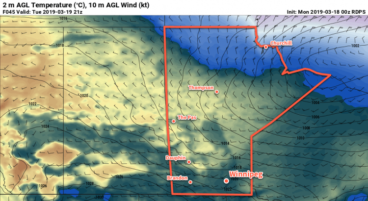
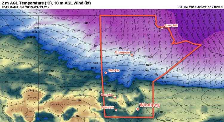
More warm weather is on the way for Saturday, too! More warm air will spread across the province by a powerful storm system moving across Hudson Bay. Winnipeg will see highs climb up to around 6 or 7°C but – broken record here – areas of the city with less snow could see temperatures climb into the double digits. Winds will be a bit more noticeable, though, out of the south-southwest at 20 km/h. Skies should start out mainly sunny, but the city may see partly cloudy skies develop in the afternoon.

A slight cool-down arrives on Saturday evening as a cold front slumps southwards through the region. It will bring some cloud, a chance of flurries, and northeasterly winds of 30 to 40 km/h. Temperatures will cool to a low near -6°C on Saturday night.

Sunday will bring sub-zero daytime highs back to the city…but just barely. Under clearing skies, Winnipeg will see temperatures climb to a high near -2°C with those northeasterly winds persisting into the afternoon. The wind will ease in the evening followed by temperatures cooling to a low near -11°C.

Long Range Outlook

Warm weather returns next week with another surge of mild Pacific air. Unlike the upper ridge which dominated the region this week and kept skies clear, a more unsettled pattern is forecast. This will result in variable cloudiness with a few chances for precipitation through the week. That said, no major precipitation events look to be on tap for the region, so favourable melt conditions look like they’ll continue.

Today’s seasonal daytime high in Winnipeg is +1°C while the seasonal overnight low is -9°C.

RDPS 2m Temperature Forecast Valid 21Z Tuesday March 19, 2019

Spring Melt Continues This Week in Winnipeg

Seasonably mild temperatures will continue this week in Winnipeg, continuing a slow and steady spring melt across the region.

A potent upper-level ridge building into the Prairies will send another push of warm air across the region. A weak disturbance will push a warm front through the region today, bringing Winnipeg plenty of cloud cover. That same front will bring the city a chance for some afternoon flurries. Temperatures will climb to a high near +1°C with winds out of the south near 20 km/h. Skies will stay mostly cloudy tonight with a low near -4°C and light winds.

Tuesday will bring mostly cloudy skies to the region with westerly winds climbing into the 20 to 30 km/h range. Winnipeg will see a high near +3°C. The cloud cover should breaking up in the evening as temperatures head to a low near -3°C. Those westerly winds will ease overnight.

On Wednesday, weather systems finally leave the region alone with just a weak surface ridge1 working into western Manitoba. This will give Winnipeg light westerly winds with temperatures climbing to a high near +3 or +4°C. The city will see mixed skies, which means it will be the first day of the next few to offer the potential for lots of sunshine. If the sun does make an appearance, it will likely result in a large range of temperatures across the city. The high of +3°C is for the weather station at the airport, which is in the middle of a snow-covered field. Areas of the city that have more buildings, or have much of the snow cleared and/or melted already will likely see temperatures climb higher, potentially up to +7 or +8°C.

Temperatures will head to a low near -2°C on Wednesday night with clearing skies.

Long Range Outlook

The rest of the week is looking great; the upper ridge will bring benign weather to the region! Winnipeg can expect a fair amount of sunshine, light southerly winds, and daytime highs in the +4 to 8°C range!

This also means that milder temperatures will spread south of the border. The region will be moving into the spring flood season over the next couple weeks. As it does, flood water will begin weakening ice cover on rivers and lakes. Remember to exercise caution around frozen waterways.

Today’s seasonal daytime high in Winnipeg is 0°C while the seasonal overnight low is -11°C.

  1. Not to be confused with the upper-level ridge moving into the region!

Another Colorado Low To Bring More Snow, Wind to Southern Manitoba

Snowy and windy conditions will develop tonight across parts of southern Manitoba as a potent winter storm pushes northeastwards through the American Plains.

Winnipeg will start the day today with cloudy skies and a few fog patches. It won’t last too long though; skies will clear early this morning and temperatures will climb to a high near 0°C. More cloud will push in later this afternoon as the Colorado Low lifts northwards through the United States. By evening, snow will begin lifting through the Red River Valley into the southeastern corner of the province. As this happens, winds will strengthen out of the north, reaching 40 gusting 60 km/h by Thursday morning.

At the risk of sounding like a broken record, snowfall amounts will be tricky as once again as snow will quickly taper off on the northwestern side of this system. Right now it looks like that line will run roughly through Winnipeg, with amounts quickly dropping off to nothing northwest of the city and increasing to ≥ 10 cm to the southeast. That said, if this line shifts in either direction by even 20-30 km, that could be the difference between no snow or 10 cm of snow. Right now it appears that the city will get around 2-5 cm of snow by the time it tapers off, but we’ll keep an eye on things in case this system trends westwards.

Temperatures will remain steady near -2°C on Thursday with northerly winds continuing at 40 to 50 km/h. Blowing snow shouldn’t be too much of an issue, except for the southeastern Red River Valley. In that area, moderate snow will combine with the strong winds to produce poor visibilities in snow and blowing snow. In Winnipeg, any remaining snow should taper off mid-morning but skies will remain cloudy through the day. The wind will ease through the evening to around 20 km/h. The clouds should break up a bit overnight as temperatures head to a low near -8°C.

Friday will bring mixed to mostly cloudy skies as some morning sunshine gives way to afternoon cloud. Temperatures should reach a high near -4°C and winds will remain out of the northwest at about 20 km/h. Cloudy skies should remain in place Friday night with a low near -13°C.

Long Range Outlook

The weekend looks pleasant with temperatures returning 0°C, variable cloudiness, and light winds. Daytime highs will continue to climb into the low single digits next week.

Today’s seasonal daytime high in Winnipeg is -1°C while the seasonal overnight low is -11°C.

Seasonal Temperatures And A Bit of Snow

Winnipeg will see near seasonal temperatures through the weekend with snow developing Saturday and tapering off Sunday.

The main weather system impacting Winnipeg over the next few days will be a large Colorado Low system moving through the Northern Plains. It will spread warmer air northwards into southern Manitoba today, finally bringing a near-seasonal high to Winnipeg. That warmer air moving into the region will also produce mixed skies today as cloud cover builds northwards. Temperatures will stay mild tonight with a low near -10°C and mostly cloudy skies.

Winnipeg will see snow build into the region on Saturday. Snow will spread northeastwards out of North Dakota into the Red River Valley midday. The city will see a near-seasonal high of -3°C and light winds. The snow will ease on Saturday night, leaving around 3-5 cm in Winnipeg with amounts of 5-10 cm to the south and east. Breezy northwesterly winds near up to 30 km/h will move into the region in the evening. Temperatures will dip to a low near -10°C.

GDPS 24hr. Snowfall Accumulation (10:1 SLR) valid 12Z Sunday March 10, 2019
Snow will spread across southeastern Manitoba on Saturday.

The cloud cover will stick around for Sunday with a continued chance for some light snow. Northwesterly winds near 30 km/h will keep temperatures cooler than Saturday with a high near -5°C. Skies will clear out on Sunday night with temperatures dipping back into the low minus teens.

Long Range Outlook

Winnipeg will see a sunny day on Monday with near-seasonal temperatures, but the reprieve will be short-lived. Most guidance continues to forecast another major Colorado Low developing early in the week. Winnipeg would be under the influence of this system form Tuesday through Thursday, and it would bring the potential for a wintery mix of precipitation across the province. Snowfall may end up being a significant concern with this system; some models show the potential for a band of 20-30 cm of snow slicing across the Red River Valley. With flooding concerns mounting, a foot of heavy, wet March snow certainly wouldn’t help the situation.

Today’s seasonal daytime high in Winnipeg is -3°C while the seasonal overnight low is -13°C.