More Snow With Steady Temperatures

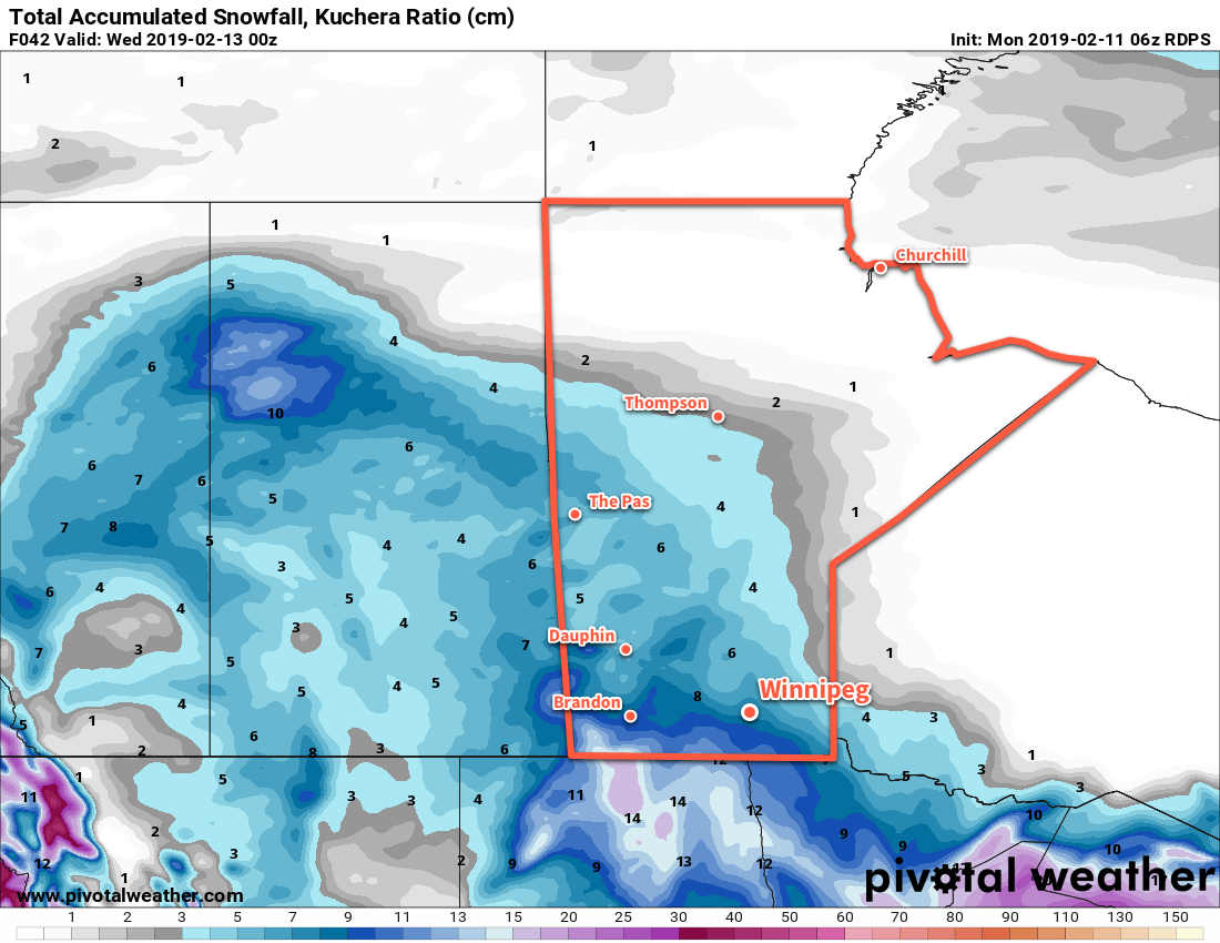
Winnipeg will see 5 to 10 cm of snow beginning today as temperatures stay steady at below-seasonal values through the rest of the work week.

Winnipeg will see more snow push into the city this morning that will persist through much of the night. The snow will come in two batches; the first will move through midday before easing in the afternoon, then the second will develop in the evening and persist through the night. By the time the snow tapers off on Thursday morning, the city will likely see 5 to 10 cm of the white stuff. Once the snow moves off, the city will see mixed skies for Thursday that will further clear out for Friday.

Much of southern Manitoba will see 5 to 10 cm of fresh snow by the time the disturbance laves the province on Thursday morning.

Daytime highs will be fairly steady the next few days, generally around the -15°C mark. Overnight lows, however, will slowly drop as an Arctic high builds in from the west. The city will see a low near -21°C tonight and will then drop towards -27°C by the end the week.

Winds will stay light through much of the snow event today, but will pick up out of the northwest overnight and increasing to 30 gusting 50 km/h for Thursday. Those winds will gradually ease Thursday night into Friday.

Long Range Outlook

Temperatures will continue at below-seasonal values through the weekend, but nothing like the frigid cold seen last week. Daytime highs look to stay in the mid-minus teens while overnight lows dip into the -20s. Winnipeg will see little change heading into the first half of next week.

Today’s seasonal daytime high in Winnipeg is -8°C while the seasonal overnight low is -19°C.

Finally: Snow Brings A Break From The Cold

Winnipeg will see a much-welcome return to seasonal temperatures as snow moves into the region.

A developing disturbance called an inverted trough will move into Manitoba today, bringing cloud, light snow, and much warmer temperatures. Winnipeg will see sunshine this morning replaced by increasing cloudiness in the afternoon. As the cloud pushes in, temperatures will climb to a high around -10°C. Light snow will spread across the Red River Valley this evening and continue through the night. The city should see close to 5 cm of snow by Tuesday morning. With the cloudy skies and inverted trough moving through, temperatures should stay steady near -11°C through the night.

The city will see light snow through much of Tuesday with another 2 to 4 cm likely. Temperatures will climb to a high near -9°C as the inverted trough continues through the province. Snow will taper off sometime late in the afternoon or early evening leaving behind mostly cloudy skies with a chance of flurries. Temperatures will head back to a low near -20°C on Tuesday night.

Much of southern Manitoba will see 4-8 cm of snow over the coming 48 hours, although note that this forecast snowfall map is likely producing slightly higher amounts along the Manitoba-U.S. border than expected.

Another disturbance tracking along the U.S. border will bring more cloud and a chance of light snow to the region on Wednesday. Winnipeg will have cooler high near -15°C. After this disturbance passes, another Arctic high will slowly begin building back into the region. Overnight lows will dip down to around -22°C on Wednesday night.

Long Range Outlook

The rest of the week will bring variable cloudiness and below-seasonal temperatures. The cool conditions won’t be as extreme as the last cold snap, though, with daytime highs in the minus teens and overnight lows dipping into the -20s.

Today’s seasonal daytime high in Winnipeg is -9°C while the seasonal overnight low is -19°C.

Light Snow Can’t Beat The Cold

Winnipeg will see cold conditions right through weekend, punctuated by light snow midweek.

Winnipeg will continue to see periods of light snow and seasonably cool conditions this week. Today, light snow will gradually taper off over the city this morning leaving behind cloudy skies with some occasional flurries. Temperatures will top out around -18°C today, but a breezy northerly wind of 20 to 30 km/h will keep it feeling cold. The chance for flurries or light snow will continue tonight with a low near -25°C.

Thursday will be a cold day in Winnipeg. Temperatures will only climb to a high near -21°C while a northerly wind near 30 km/h produces wind chill values in the -30 to -35 range. The upper trough moving through will continue to produce a chance of flurries or some organized light snow. The isn’t forecast to receive much snow; one will likely need to head into south-eastern Manitoba to see more than 2 cm fall on Thursday. Skies will begin to clear out on Thursday evening with temperatures plummeting back down into the -30s overnight. Winds will continue at 20 to 30 km/h for much of the night before diminishing early Friday morning.

Southern Manitoba will be grazed by more snow overnight Wednesday into Thursday.

Friday will be a fairly sunny and cold day through the Red River Vally as an Arctic ridge moves through. Under light winds, the temperature will climb to only around -23°C. The city may see some cloud push in overnight, but not before temperatures dip down to around -30°C again.

Long Range Outlook

Cloudy skies return to the city on Saturday while below seasonal temperatures stay right through the weekend. Forecasts show a moderation in temperature to only slightly below seasonal values to start next week, but no significant warming trend is on the horizon.

Today’s seasonal daytime high in Winnipeg is -10°C while the seasonal overnight low is -21°C.

Snowy Weekend Ahead

A significant change in the weather is on tap for Winnipeg this weekend as temperatures return to near-seasonal values alongside plenty of cloud and light snow.

It’s a milder, cloudy weekend ahead for Winnipeg. A series of disturbances will push eastwards over the coming days, bringing unsettled conditions to southern Manitoba. Starting with today, Winnipeg will see cloudy skies with about 2 cm of light snow that will taper off later this afternoon. Temperatures will climb to a near-seasonal high of -13°C with 30 km/h southerly winds in the morning tapering off and shifting to the north. The city will likely see periods of light snow overnight as temperatures dip to a low near -20°C.

Saturday will see Winnipeg dodging a fairly substantial winter storm. A broad area of moderate to heavy snow will pass north of the city, beginning over western Manitoba and spreading across the Interlake into eastern Manitoba through the day. Snowfall totals over western Manitoba could reach 30 cm with 10 to 15 cm likely for the Interlake and areas east. The city will likely see cloudy skies and periods of light snow, but accumulations of only 2 to 4 cm.1 Temperatures will climb to a high near -15°C and winds will be out of the northeast near 20 km/h. The snow will taper off Saturday evening followed by some breaks in the cloud and a low near -20°C.

A large swath of the Prairies will see up to 30 cm of snow over the next 2 days, but Winnipeg is forecast to miss out on most of it.

Winnipeg will see mainly cloudy skies on Sunday ahead of the next system developing that will move through the region. Most forecast models show a significant Colorado Low developing Sunday into Sunday night. There’s some uncertainty as to where the main snow for this system will set up; some models push it across southern Saskatchewan into southern Manitoba while others keep it primarily south of the border with southern Manitoba just seeing a glancing blow. Ultimately, the details won’t become clear until a bit closer to the event. If it is going to snow, it’s likely that snow wouldn’t push into the region until a bit later in the day on Sunday. The city will see a high near -14°C with northeasterly winds continuing. Temperatures will head to a low near -24°C with a chance of snow on Sunday night.

Long Range Outlook

Next week will start with any remaining snow moving out of the region, followed by a prolonged stretch of below seasonal temperatures. It won’t be as cold as the last cold snap, but it does look like much of the week will see daytime highs near -20°C with overnight lows near -30°C.

Winnipeg’s seasonal daytime high is currently -11°C while the seasonal overnight low is -21°C.

  1. If this system ends up tracking a bit further south, however, Winnipeg could easily see 5 to 10 cm of snow.