Bitter Cold Gradually Eases

Winnipeg will slowly emerge from the bitter cold with a climb back towards seasonal temperatures.

Winnipeg will see yet another day in the deep freeze today. With the Arctic high still working its way across the province, the temperature will struggle to a high near -30°C in the city today. Fortunately, winds will remain light through the day, making the cold slightly more tolerable. Temperatures will dip to a low near -36°C tonight before some cloud cover begins building into the region.

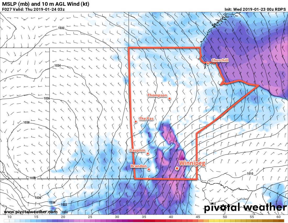
Thursday will bring milder temperatures as Winnipeg climbs to a high near -25°C. Winds will be out of the southeast in the 20 to 30 km/h range, producing wind chills in the -35 to -40 range. The city will see a slight chance of flurries with little to no accumulation. Temperatures will slowly increase overnight to around -23°C by Friday morning.

Markedly warmer temepratures will spread across the southern Prairies on Friday.

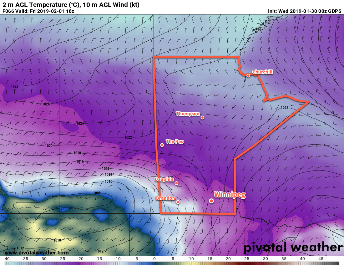
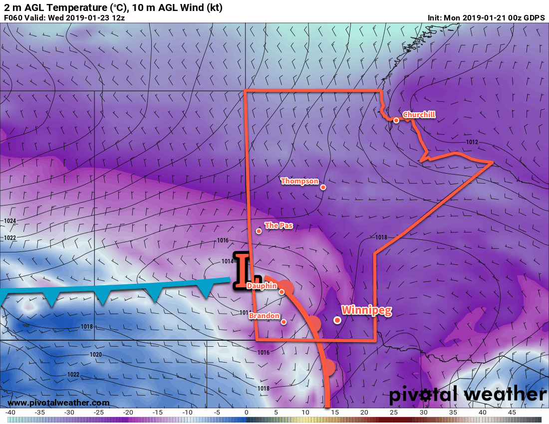
A series of disturbances will track across the province on Friday. These systems will bring plenty of cloud alongside near-seasonal temperatures to the region with highs near -11°C. The first is forecast to pass through on Friday morning, followed by the second one on Friday night into Saturday morning. These systems will bring a swath of 5 to 10 cm of snow western Manitoba and the Interlake, but here in Winnipeg there will just be a chance for a bit of light snow. Winds will once again be out of the south at 20 to 30 kn/h for much of the day. Skies will remain cloudy on Friday night as temperatures dip to a low near -13°C.

Long Range Outlook

Temperatures should remain for much of the weekend with highs near -10°C and overnight lows in the minus teens. A major pattern change is possible on Sunday as a long-wave trough moves into the region. Current forecasts indicate the development of a Colorado Low that would lift northeastwards into Minnesota on Sunday night, spreading a large area of snow across the region late Sunday into Monday, followed by breezy northerly winds and falling temperatures. Early indications are that this system could produce as much as 15 to 20 cm of snow. This leaves the city with a the chance that we may be starting off the next work week with the aftermath of a notable snow storm!

Winnipeg’s seasonal daytime high is currently -11°C while the seasonal overnight low is -22°C.

Deep Freeze Blasts Back Into Southern Manitoba

After a break that seems all too short, Winnipeg will plunge into the deep freeze tonight. A reinforced surge of Arctic air will spread back into southern Manitoba in the wake of an Alberta clipper moving through the province today.

Winnipeg will see cloudy skies with a mild high near -9°C today. By mid-afternoon, the city will likely see some light snow push into the region with 1-2 cm accumulation possible. The big change in the weather will come this evening as a cold front surges southwards through the Red River Valley behind this clipper system. Winds will pick up out of the northwest to 40 gusting 60 km/h and begin ushering in a much colder air mass. These winds will produce areas of blowing snow, however the worst conditions will occur in the lee of Lake Manitoba. In this area, roughly along a line from Lake Manitoba SSE to Emerson, white-out conditions in blowing snow will be possible. Skies will gradually clear overnight as temperatures plummet to a low near -28°C. The wind will ease overnight to 30 gusting 50 km/h by Thursday morning.

Moderate north-northwest winds will bring widespread blowing snow to much of the Red River Valley on Wednesday evening.

The rest of the week? Cold. A potent Arctic ridge will settle over the province for the next couple days, bringing temperatures well below seasonal back to the region. Winnipeg will see a high of just -24°C today with partly cloudy skies. Temperatures will drop to a low near -33°C tonight with light winds. Friday will see temperatures climb to -24°C again under clear skies. Temperatures will dip to a low near -28°C on Friday night.

Long Range Outlook

Temperatures will moderate just slightly this weekend with daytime highs reaching just above -20°C. A low pressure system may bring some snow to the city on Sunday, then will usher in another shot of potent Arctic air. Next week will bring a prolonged period of cold with daytime highs below -20°C expected through the week.

Looks like “Winterpeg” wants to end January by living up to its name!

Winnipeg’s seasonal daytime high is currently -12°C while the seasonal overnight low is -23°C.

The Deep Freeze Eases in Winnipeg

The deep freeze that gripped Winnipeg through the weekend will finally ease to start the new work week. Near-seasonal temperatures and cloudier conditions will move in for the next few days.

Temperatures will finally climb to a near-seasonal high of -13°C today, but will be offset by a moderate southerly wind. Unfortunately, 30 to 40 km/h winds will keep wind chills in the -25 to -30 range for much of the day. Conditions will improve later this afternoon as the winds diminish to light. The region will see cloudy skies through the day and there will be chance of flurries. Temperatures will remain seasonably mild tonight with a low near -16°C as a trough of low pressure moves through.

Mixed skies will return to Winnipeg on Tuesday as a weak ridge of high pressure moves into the region. Northwesterly winds near 20 km/h will diminish to light in the afternoon with temperatures will climb only just a bit to around -14°C. Winnipeg should see clear skies to start night, allowing temperatures to dip to a low near -21°C. Some cloud cover will begin to work into the region towards Wednesday morning as the next low pressure system approaches from Saskatchewan.

A low pressure system will track through the Red River Valley on Wednesday.

Wednesday will bring mainly cloudy skies back to Winnipeg as a low pressure system moves through the region. Temperatures will climb to a high near -8°C with a chance for some light snow, particularly late in the day. A strong cold front will push through the Red River Valley on Wednesday night behind this low. Winds will pick up out of the northwest to 40 gusting 60 km/h as skies clear and the temperature plummets to around -27°C

Long Range Outlook

The remainder of the week sends Winnipeg back into the deep freeze with highs in the -20s and lows in under -25°C. Moderation is possible this weekend, but the trend of below-seasonal temperatures is forecast to continue through the weekend into next week.

Winnipeg’s seasonal daytime high is currently -13°C while the seasonal overnight low is -23°C.

Major Pattern Change Brings Arctic Chill Back to Winnipeg

An Alberta clipper will move through the region on Tuesday, ushering in a blast of frigid Arctic air.

Warm weather continues in Winnipeg today and tomorrow with daytime highs in the low minus single digits. The city will see some sunshine today, but cloudy skies will return for Tuesday as an Alberta clipper moves through the province. This system will bring a major change in the overall weather pattern over western Canada and usher in an outbreak of potent Arctic air. The city will see a chance of some light snow tonight and Tuesday as the low moves by followed by a strong cold front. Amounts are forecast to remain light with the accumulating snow remaining further north across central portions of the province. Winds will be light today the pick up out of the south into the 20 to 30 km/h range tonight.

The snowfall associated with the Alberta clipper will fall mainly through northern Saskatchewan and central Manitoba.

A potent cold front will sweep through the Red River Valley early Tuesday morning, ushering in strong northerly winds of 40 gusting 60 km/h. These winds will bring colder air in through the day, resulting in temperatures falling to around -18°C by the evening. The winds will ease late in the day as the Arctic ridge builds into the region. Temperatures will fall to a low near -29°C on Tuesday night with clearing skies.

Temperatures will be near 10°C below seasonal in Winnipeg on Wednesday.

Wednesday will bring a few clouds and cold temperatures to Winnipeg. Winds will remain light with temperatures recovering to a seasonably cold -20°C. Temperatures are a bit tricky for Wednesday night; if the city continues to see variable cloudiness, temperatures will remain in the -20 to -25°C range. If skies clear, though, it could be another night with a low near -30°C.

Long Range Outlook

The remainder of the week will be cold with highs in the low minus teens or minus 20s and overnight lows near -30°C. Winnipeg will see plenty of sunshine through the latter half of the week. Brrrr.

Winnipeg’s seasonal daytime high is currently °C while the seasonal overnight low is °C.