Milder Temperatures and Light Snow Return To The Red River Valley

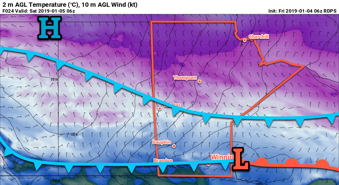
A warm front pushing across the Red River Valley on Wednesday night will usher in milder temperatures with periods of light snow to end the week.

Winnipeg will see mainly sunny skies and near-seasonal temperatures today as an Arctic high moves through the region. Temperatures should reach a high near -15°C with light winds. Temperatures will drop into the -20s tonight, then rise to around -15°C with increasing cloud by Thursday morning as a warm front approaches. Some light snow may develop overnight, but dry air coming out of the Arctic high may hold off the snow until later Thursday morning.

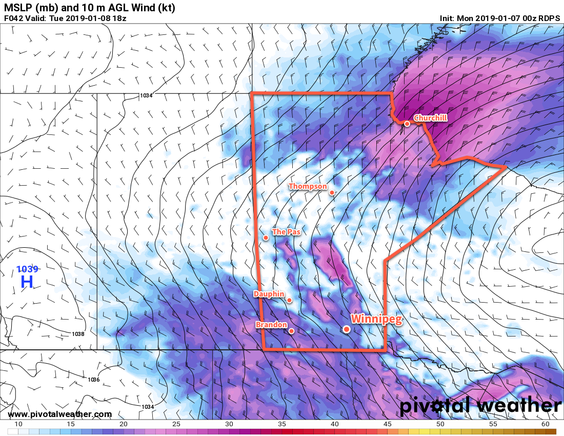
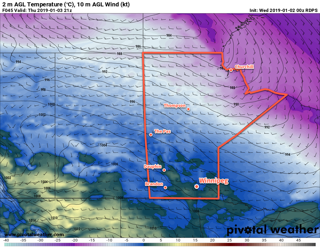
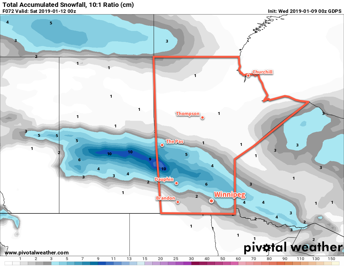
On Thursday, a warm front pushing eastwards across the region will warm temperatures to a high near -9°C with southeasterly winds increasing to 30 gusting 50 km/h. Winnipeg & areas south will see some periods of light snow through the day, but most areas will see limited accumulations of less than 2 cm. The main area of accumulating snow with this system will be much further north, with a band of 5 to 10 cm moving out of central Saskatchewan and across the northern Interlake. Winds will ease Thursday night as a weak low pressure centre moves into the Red River Valely. Temperatures will keep steady near -10°C with cloudy skies and periods of light snow. 1 to 3 cm accumulation is possible by morning.

A low pressure system will bring accumulating snow to portions of central Manitoba and light snow to Winnipeg and the Red River Valley through the second half of the week.

On Friday, the low centre will slowly exit the region. Temperatures will be seasonably mild with a high near -8°C in Winnipeg. Cloudy skies will continue with periods of light snow through the day. Accumulations will once again be minimal. Behind the low, light northerly winds will develop as a weak Arctic ridge begins building into the region. Winnipeg should see a low near -16°C on Friday night with as the cloud cover begins to break up.

Long Range Outlook

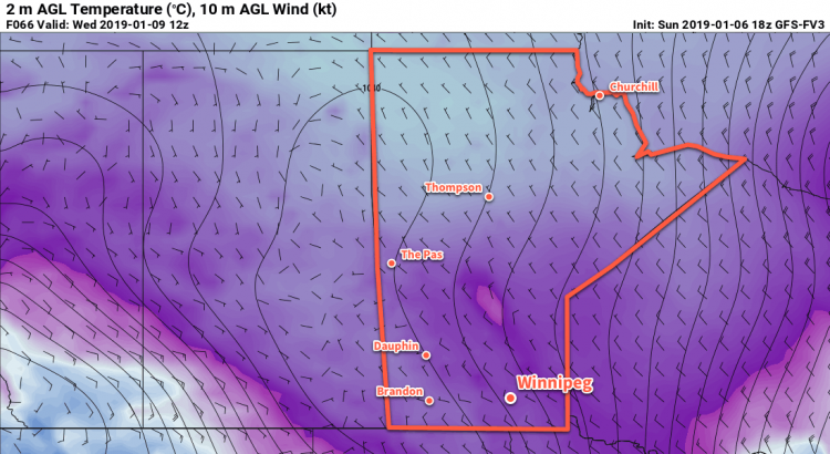
Forecasts show conditions remaining seasonably warm for Winnipeg over the weekend and into next week. The city should see some sun through the weekend, but cloudier conditions are forecast to return next week. The next chance for accumulating snow is Monday night or Tuesday when an Alberta Clipper may move through the province. Colder temperatures are forecast to move into the region behind this system for the second half of next week.

Winnipeg’s seasonal daytime high is currently -13°C while the seasonal overnight low is -24°C.

Blustery Return to Colder Conditions

Winnipeg will see mild temperatures near the freezing mark today, but a cold front moving through tonight will send temperatures plummeting.

Following last night’s dump of snow, conditions today will be pleasant. With temperatures hovering near 0°C through the day, skies will clear with west-southwesterly winds picking up into the 20 to 30 km/h range. It will be short-lived, though: a cold front moving through this evening will bring deteriorating conditions to the Red River Valley. The front will pass through early this evening with winds strengthening to 40 gusting 60 km/h behind it. Cloud cover and flurries will move back into the region and temperatures will head towards a low near -11°C.

The combination of significant cooling, some additional light snow, and strong winds will produce poor driving conditions. Wet roads, some snow-covered, will likely re-freeze in the late evening or shortly after midnight as temperatures cool into the low single digits. The flurries and strong winds will produce widespread drifting and blowing snow. Drivers should prepare for the potential of icy roads and/or poor visibility if travel plans extend into the evening.1

The city will see cloudy conditions on Tuesday with falling temperatures as an Arctic high builds into the region. Moderate northwesterly winds of 30 to 40 km/h will persist as temperatures fall to around -15°C. The entire region will see a chance of scattered flurries through the day alongside localized areas of blowing snow. The wind will begin to ease on Tuesday night, bringing an end to the blowing snow. Unfortunately, the diminishing winds marks the arrival of the Arctic high; temperatures will dip to a low near -24°C on Tuesday night under clearing skies.

Moderate winds on Tuesday will usher in colder temperatures and support areas of blowing snow.

On Wednesday, Winnipeg will find itself entrenched in the Arctic air. Temperatures will climb to a high of just -17°C with light winds. Skies will likely begin the day clear, but a few clouds will work into the region in the afternoon. More cloud will build in overnight as a warm front pushes eastwards across the southern Prairies. This will help prevent overnight lows from dropping too much, only to around -21°C before climbing to about -18°C by Thursday morning. There will be a chance of snow late overnight.

Long Range Outlook

Forecasts show another disturbance tracking through the Red River Valley on Thursday that could bring another couple centimetres of snow to the region. Once it passes, the region will see a return to milder temperatures for the weekend with variable cloudiness. By Sunday, Winnipeg may see daytime highs near -5°C with overnight lows near -10°C, much warmer than seasonal for mid-January.

Winnipeg’s seasonal daytime high is currently -13°C while the seasonal overnight low is -24°C.

  1. In a somewhat rare change of pace, the strong winds will be generally westerly, meaning it will be north-south running highways that see the greatest potential impact from blowing snow.

A Short-Lived Return to Seasonal Temperatures

Winnipeg will see a short-lived return to seasonal temperatures over the next couple days. The warm weather won’t be absent long, though, returning on Sunday and bringing a fresh batch of snow to wrap up the weekend.

Winnipeg will see one more seasonably mild day today as temperatures climb to a high near -3°C. The city will see a mix of sun and cloud through the day with light winds. The variable cloudiness will continue tonight, but a cold front slumping southwards will send overnight lows around -10°C. Winds will shift northerly at 15-20 km/h overnight.

Saturday will bring more cold air southwards across the Prairies in the wake of the cold front. Temperatures in Winnipeg will slowly drop through the day to around -14 by late in the afternoon. Skies will remain mixed, although a bit more clearing could work into the Red River Valley late in the day. Tomorrow’s overnight low is tricky; temperatures will drop under a ridge of high pressure moving through the region, but cloud cover moving into the region will start sending temperatures back the other way. It seems likely that Winnipeg will get to a low near -17°C before rising back to around -13°C by Sunday morning. If it stays clear a bit longer, then lows could dip down to around -20°C or even a slight bit cooler.

A series of cold fronts passing through the region will bring cooler temperatures to Winnipeg on Saturday.

On Sunday, a milder air mass will once again work its way back into the region. Skies will remain cloudy in Winnipeg with southeasterly winds picking up into the 30-40 km/h range. Temperatures will climb to a high near -6°C. Sometime in the afternoon or early evening, snow will begin spreading across the Red River Valley. The snow will persist through the night as temperatures rise to around -3°C. The city could see around 5 cm of fresh snow by Monday morning.

Long Range Outlook

Monday will bring clearing skies with any remaining snow tapering off in the morning. Temperatures will be seasonably mild with a high near -1°C. The remainder of the week is looking on the cloudier side with temperatures swinging between milder and seasonable conditions as the city moves out of and into Arctic air masses. No significant snowfall is forecast after Sunday night’s accumulations for the remainder of the week.

Winnipeg’s seasonal daytime high is currently -13°C while the seasonal overnight low is -23°C.

More Warm Weather On The Way

Temperatures will soar well above seasonal values in Winnipeg as a flood of mild Pacific air washes over the southern Prairies.

A warm front pushing eastwards across the Red River Valley this morning will bring above-seasonal temperatures back to Winnipeg today. To start the day, Winnipeg may see a few flurries as the warm front pushes into the region. Once the front leaves, Winnipeg will see mixed skies with light southerly winds. Temperatures will climb to around -10°C by lunch and then inch towards a high of -8°C in the afternoon. Skies will cloud back over tonight as another warm front pushes into the region. This front will bring a chance of some light snow – and a risk of freezing rain – to the region late overnight into early Thursday morning. Temperatures will continue to rise overnight to around -2°C by morning.

Thursday will bring mainly cloudy skies to Winnipeg and the Red River Valley as a mild Pacific air mass spreads over the region. Temperatures will continue to climb to a high near 0°C with southwesterly winds of 20 to 30 km/h. Thursday night will bring mixed skies with a low near -5°C.

Temperatures will climb to near- or above-freezing across much of southern Manitoba on Thursday

On Friday, the region should see plenty more cloud as temperatures once again climb to around 0°C. A low pressure system moving through the Interlake will bring southwesterly winds of 20 to 30 km/h to the Red River Valley on Friday afternoon. Winds will shift northwesterly on Friday night as temperatures dip to a low near -5°C.

Long Range Outlook

Temperatures will remain mild this weekend with daytime highs in mid-minus single digits. Sunday and Monday may bring a chance for some light snow as a larger low pressure system develops and moves through the region. Slightly above-seasonal temperatures will continue into the middle of next week with variable cloudiness.

Winnipeg’s seasonal daytime high is currently -13°C while the seasonal overnight low is -23°C.