Winnipeg Sets Off On A Temperature Roller Coaster

Winnipeg will see temperatures swing from the deep freeze back to seasonably mild by the end of the weekend as an Alberta clipper pushes out an Arctic high.

Temperatures will be cold in Winnipeg today as an Arctic high settles over the region. Temperatures today will be seasonably cold in the Red River Valley at around -20°C. Breezy northerly winds this morning of 20 to 30 km/h will ease through the day. Then, attention turns to a potent Pacific system making landfall. As it moves onshore, it will push a warm front eastwards across the Prairies. That surge of warm air pushing across the Prairies will keep temperatures from dropping too much tonight. Winnipeg should see a low near -24 or -25°C before temperatures begin to moderate early Saturday morning. Skies will start the night clear, but should see cloudiness increase early Saturday morning.

Saturday will bring mainly cloudy skies to Winnipeg. Snow isn’t too likely, but a few flakes may fall through the day. Temperatures will return to seasonal values with a high near -11°C. Winds will become an issue in the afternoon, though, increasing out of the south to into the 30 to 40 km/h range. This will result in some blowing snow through the Red River Valley. Expect locally poor travel conditions on west-east highways in the area. Those breezy winds will continue into the night and keep temperatures mild. Winnipeg will see temperatures remain steady near -11°C under cloudy skies with a chance of light snow.

Total snowfall is forecast to be near 2-4cm in WInnipeg with this weekend's clipper system.
Total snowfall is forecast to be near 2-4cm in WInnipeg with this weekend’s clipper system.

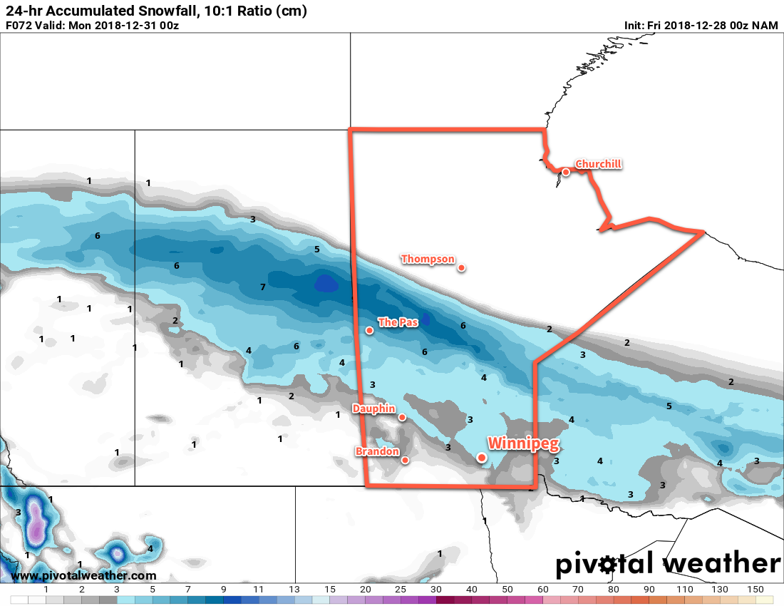
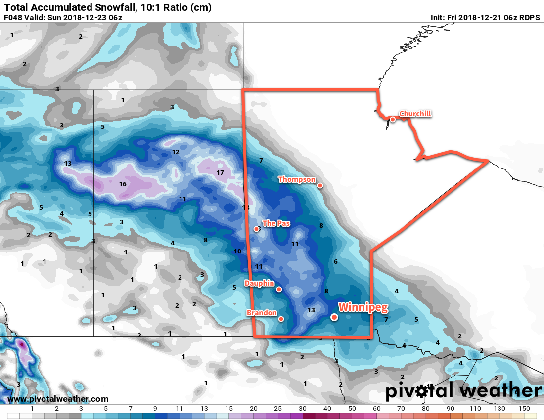
By Sunday, that Pacific system will have developed into a punchy Alberta Clipper. It will move from central Saskatchewan into southwestern Manitoba on Sunday morning, dragging an area of snow southwards from the central Prairies. Winnipeg will see periods of snow through Sunday with light winds. While it will snow all day, accumulations should remain relatively low in the Red River Valley. Winnipeg may see 2 to 4 cm with decreasing amounts south of the city. Temperatures will be mild with a high near -7°C, but things will take a turn on Sunday night as a cold front surges southwards behind the clipper system. Winnipeg will see a low near -19°C with even colder temperatures on the way to start next week.

Long Range Outlook

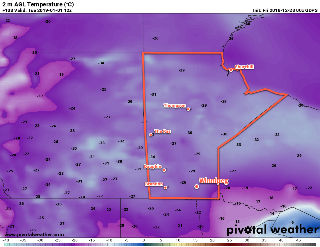
Some snow may linger into Monday morning, but by the end of the day things should clear out. Then, another outbreak of Arctic air will move into the region. Daytime highs will plummet back into the low minus teens or minus twenties to start the week. Tuesday morning may even bring the first -30°C overnight low of the season!

Many long-range models are forecasting temperatures near -30°C bright and early on to kick off January 1, 2019.

The cold outbreak will be short-lived with seasonal temperatures returning mid-week. The end of next week should bring seasonably mild conditions with little to no chance for any accumulating snowfall.

Winnipeg’s seasonal daytime high is currently -12°C while the seasonal overnight low is -22°C.

Snowy Weekend Ahead

A low pressure system will move into Manitoba today and spread snow throughout the province that will last through the weekend.

A rather potent low pressure system over western Saskatchewan will move into Manitoba later today, spreading a broad area of snow across the province. This system will stall out, resulting in periods of light snow that will persist right through the weekend.

Winnipeg will see cloudy skies today with a few flurries. Breezy southeasterly winds will increase in the 30 to 40 km/h range as temperatures climb to a high near -6°C. Light snow will move into the city late this afternoon and persist right through the night. By Saturday morning, Winnipeg will likely have around 5 cm of fresh snow on the ground. Those breezy southeasterly winds will diminish late overnight. Temperatures will rise through the night in Winnipeg, reaching around -3°C by morning.

Saturday will bring periods of light snow to the city. Winds will remain fairly light with temperatures steady near -4°C. The light snow will continue right through the evening and into the night. Winds will pick up out of the northwest to around 20 km/h in the evening, sending temperatures to a low near -8°C.

Winnipeg could see close to 10 cm of snow by Saturday evening.

Winnipeg will continue to see cloudy skies on Sunday, but much of the organized snow will be over. A few flurries will stick around through the region with diminishing winds. Winnipeg will see temperatures hover near -8°C through the day before dipping to a low near -16°C Sunday night. By the time the snow comes to an end, Winnipeg will likely accumulate close to 10 cm of snow.

Long Range Outlook

Looking ahead to the Christmas holidays, it looks like Winnipeg will be seeing close to seasonal temperatures and a fair amount of cloud. Daytime highs are forecast to drop into the mid-minus teens to start next week with overnight lows close to -20°C. No significant snow is in the forecast. Overall, it looks like a fairly seasonable white Christmas with good travel conditions!

Winnipeg’s seasonal daytime high is currently -11°C while the seasonal overnight low is -22°C.

Weather Turning More Unsettled

After a stretch of relatively benign weather, things will be getting slightly more active in Winnipeg through the remainder of the week.

Kicking off the trend towards unsettled weather, Winnipeg will see a mild but potentially messy day today. The culprit for our weather will be a low pressure system tracking through the Interlake today. It brings with it the chance for light precipitation through much of the day, but what exactly falls from the sky will vary as the day moves on. There will be a slight chance of rain or freezing rain showers, [freezing] drizzle, and/or flurries in Winnipeg today. The overall amounts of precipitation will remain low, but it will be a generally damp day. Temperatures will climb to a high near +1°C with winds picking up to northwest 30 gusting 50 km/h this afternoon. Any leftover flurries will clear out this evening. Winds will ease overnight with a few clear patches developing as temperatures head to a low near -11°C.

Freezing rain is possible over the Red River Valley early this morning.

A ridge of high pressure move over the region on Thursday. Winnipeg will see mixed skies, light winds, rand a high near -6°C. Clouds will thicken up on Thursday night as temperatures head to a low near -10°C.

On Friday, the city will see southerly winds of 30 to 40 km/h develop ahead of an Alberta Clipper tracking across Saskatchewan. Skies will stay cloudy through the day as temperatures head to a high near -5°C. Some light snow will likely push into the Red River Valley in the evening with accumulations near 5 cm possible by Saturday morning. Temperatures will keep steady near -4°C on Friday night as winds slowly ease.

A broad area of snow will develop across Manitoba on Friday night.

Long Range Outlook

Winnipeg may see more snow on Saturday as the clipper system slows, blocked to the east by a major winter storm on the east coast. Temperatures will head back towards seasonal for Christmas with variable cloudiness. One thing to keep an eye on will be a second clipper system that is forecast to track through SE Saskatchewan into North Dakota on Christmas Eve. If its track ends up just a tad further north, then it may impact travel conditions in the Red River Valley for Christmas Eve.

Overall, though, the forecast continues to be relatively pleasant for December.

Winnipeg’s seasonal daytime high is currently -11°C while the seasonal overnight low is -21°C.

Temperatures Climb Back Towards 0°C Again

Winnipeg’s temperatures will bounce right back to well above-seasonal values with variable cloudiness to start off the week.

The city will see mixed to partly cloudy skies today and tomorrow as a warmer air mass builds back into the region. Winds will pick up out of the south to 30 gusting 50 km/h midday as temperatures head to a high near -6°C. The city will see partly cloudy to mixed skies. Winds will ease tonight as temperatures head to a low near -8°C. Skies will remain mixed overnight.

Tuesday will see much lighter winds as a trough of low pressure moves through the province. Temperatures in Winnipeg will climb back towards 0°C again with partly cloudy skies. The next approaching low pressure system will strengthen winds back into the 20 to 30 km/h on Tuesday night. More clouds will push through overnight with a slight chance of flurries.

Wednesday will be a mild day with a high near +1°C with mixed to mostly cloudy skies. Winds will be light throughout the day, gradually shifting from southerly to northwesterly as a trough moves through. The wind will pick back up to around 20 to 30 km/h on Wednesday night with temperatures dropping to a low near -6°C.

So other than a chance for a bit of light snow on Tuesday night, Winnipeg will see increasingly mild temperatures with variable cloudiness.

Long Range Outlook

Temperatures will cool slightly for the second half of the work week with fairly cloudy conditions. Snow is possible late Friday into early Saturday as an Alberta Clipper moves through. In the wake of this system, breezy northwesterly winds will usher seasonal temperatures back into the region.

Winnipeg’s seasonal daytime high is currently -11°C while the seasonal overnight low is -20°C.