Cloudy Conditions Bring Warmer Weather

You need to take the good with the bad: while Winnipeg will see milder temperatures today, it comes at the cost of a long stretch of cloudy skies.

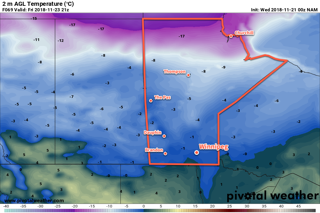
A low pressure system tracking through the central Prairies has spread mild temperatures into Winnipeg and the Red River Valley. Unfortunately, while many will appreciate the warmth, overcast skies will blanket Winnipeg for much of the next few days. Temperatures will climb to a high near 0°C today with light southerly winds turning northwesterly in the afternoon. Some flurries are possible in the evening and overnight as a cold front slides through and winds of 20 to 30 km/h pick up out of the northwest. Temperatures will dip to a low near -6°C.

Behind the cold front, Arctic air will slowly push southwards into the Red River Valley. As a result, temperatures will remain relatively steady near -6°C. There will continue to be a chance for some flurries with northwesterly winds of 20 to 30 km/h. On Saturday night, temperatures will dip to a low near -12°C with northwest winds around 20 km/h. Skies will cloudy all day and through the night.

Saturday will see temperatures remain steady near -6°C in Winnipeg as an Arctic air mass gradually pushes southwards into the Prairies.

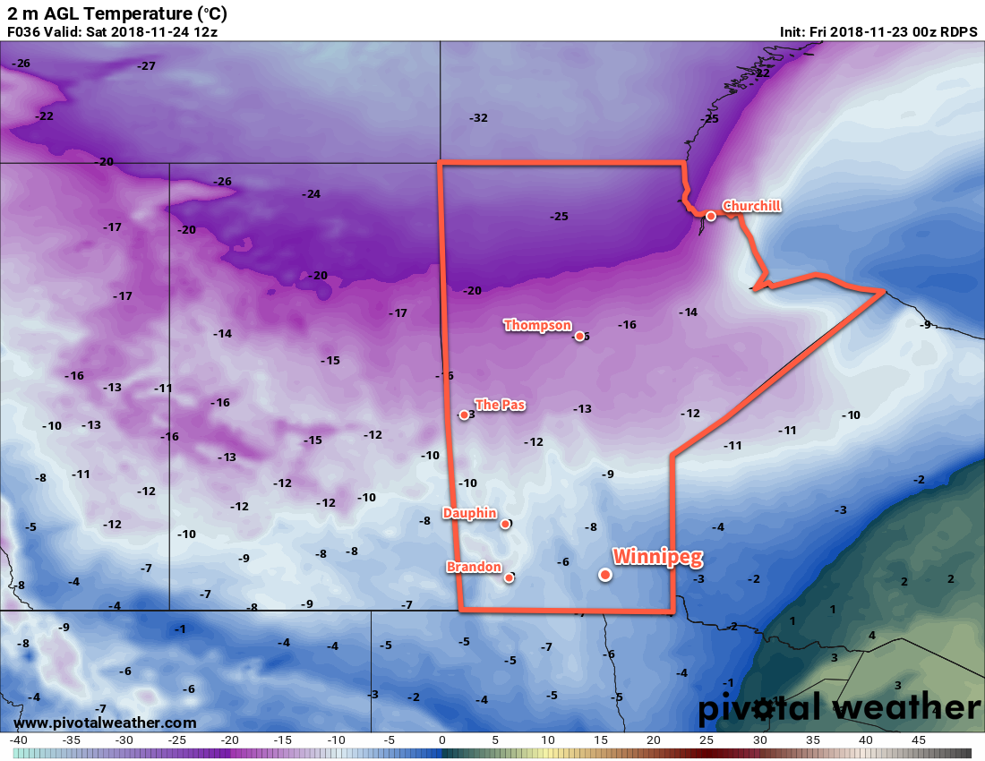
On Sunday, Winnipeg might finally see some sunshine poke through the clouds! Temperatures will be cooler yet with a high near -10°C and those northwesterly winds will continue at 15 to 25 km/h. Yet again, there may be some scattered flurries moving through the region. Skies will remain mixed to mostly cloudy on Friday night with a low near -16°C.

Long Range Outlook

Even cooler temperatures are on the way early next week as an Arctic high moves across the province. Daytime highs will dip into the -10 to -15°C range on Monday with overnight lows nearing -20°C on Monday night. The rest of the week will see temperatures gradually moderating, but they will likely still remain below seasonal values. No significant snowfall is in the forecast.

Winnipeg’s seasonal daytime high is currently -4°C while the seasonal overnight low is -12°C.

Cloudy, Breezy Conditions Usher In Warmer Weather

Increasing cloudiness and breezy conditions will usher milder temperatures into Winnipeg for the end of the work week.

A warmer air mass will begin pushing into Manitoba today, bringing increasingly southerly winds to the Red River Valley. With mixed skies leaning towards the cloudier side, Winnipeg will see winds pick up out of the southeast to 20 to 30 km/h. Temperatures will still be on the cool side today with a high near -8°C. There will be a chance of some flurries today as the warm front approaches, but no accumulations are likely. Tonight, winds will continue out of the south near 30 km/h with mostly cloudy skies continuing. The arrival of warmer air will be easily noticed with temperatures remaining steady near -8°C through the night.

Thursday will bring mostly cloudy skies to Winnipeg with winds out of the south at 30 gusting 50 km/h. Warmer air will continue to push into the region, sending the high to an above-seasonal -1°C. Mostly cloudy skies will continue on Thursday night with easing winds and a low near -4°C.

Temperatures in Winnipeg will climb towards 0°C for Thursday and Friday.

On Friday, the warmest temperatures associated with this system will be in place. Under mostly cloudy skies, high will reach 0°C with light southerly winds. Winds will shift to the north behind a trough that moves through in the evening, then strengthen overnight as a cold front slumps southwards. This cold front will also bring with it a chance for some light snow overnight. Temperatures will dip to a low near -5°C as those northerly winds pick up to around 30 km/h.

Long Range Outlook

Heading into the weekend, temperatures will slide back to well below-seasonal values. Along with the colder weather, Winnipeg will see variable cloudiness with the chance for some flurries. By the start of next week, temperatures will be back to around 5°C below normal for late-November. Those cool conditions will stick around for much of next week.

Winnipeg’s seasonal daytime high is currently -4°C while the seasonal overnight low is -12°C.

Gradual Climb Back Towards Seasonal Temperatures

After a chilly start to the week as an Arctic high moves through the province, temperatures in Winnipeg will slowly climb back towards more seasonal values.

A seasonably cold day lies ahead for Winnipeg today as an Arctic high moves through. With sunny skies, temperatures will climb to a high of just -12°C today. Winds will remain light, so – other than the fact that temperatures will be nearly 10°C below normal – one could almost consider it a pleasant day. More cloud will build back into the region this evening ahead of an approaching low pressure system. Temperatures will head to a low near -16°C with some light snow moving in for early Tuesday morning.

The snow will only last for a few hours Tuesday morning before moving out and leaving behind mainly cloudy skies for the remainder of the day. There may be occasional flurries, but there shouldn’t be any more accumulating snowfall. Winds will start the day out of the south near 20 km/h but will then switch to the north at 15 to 20 km/h for the afternoon. Temperatures will be warmer with a high near -7°C. The city will see a few clear breaks overnight as temperatures head to a low near -15°C with light easterly winds.

Wednesday will bring more cloudy skies to Winnipeg with a slight chance of some flurries. It will be a bit of a breezy day with winds picking up out of the southeast into the 20 to 30 km/h range. Winnipeg will see a high just a tad warmer than Tuesday near -6°C. Mainly cloudy skies and breezy conditions will continue Wednesday night as temperatures dip to a much milder low near -8°C.

Long Range Outlook

Temperatures will climb above seasonal values for the latter half of the work week with plenty of cloud cover in place over the region. Winds will ease for Friday, and it appears that there will be a chance for some snow on Friday night. Cooler air pushes back in through the weekend with northerly winds ushering in another Arctic ridge.

Winnipeg’s seasonal daytime high is currently -3°C while the seasonal overnight low is -11°C.

Arctic High Brings More Cold Weather

An approaching Arctic ridge will send temperatures in Winnipeg plunging well below seasonal values once again.

Colder weather returns to Winnipeg today as an Arctic ridge begins building through the Prairies. Northwesterly winds near 30 km/h will keep temperatures much cooler than seasonal today; Winnipeg’s high temperature will struggle to just -6°C. The colder air will continue to filter into the region tonight, sending temperatures down to a low near -15°C. Morning cloud will give way to breaks of sunshine this afternoon. Winnipeg will see a chance of flurries through the afternoon into the early evening. Skies will gradually continue to clear overnight with winds shifting to westerly at 10 to 20 km/h.

Flurries will be possible across much of southern Mantioba this afternoon.

The Arctic ridge will move through the Red River Valley on Saturday, bringing cool temperatures and sunny skies. Winnipeg will see a high of just -9°C with west-southwest winds of 15 to 25 km/h. Temperatures will drop to a low near -13°C on Saturday night with increasing cloudiness.

Sunday will bring fairly cloudy skies to the region, although once again sunny breaks will be possible through the afternoon. It will be another cool day with a high near -8°C and winds should be light through the day. Skies will remain mixed to mostly cloudy on Sunday night as temperatures drop to a low near -14°C.

Long Range Outlook

Next week should bring a return to seasonal temperatures by mid-week with variable cloudiness. No significant precipitation is forecast.

Winnipeg’s seasonal daytime high is currently -2°C while the seasonal overnight low is -10°C.