Seasonal temperatures will continue in Winnipeg this week, but with plenty of cloud and a bit of light snow.
Winnipeg will remain under cloudy to mostly cloudy skies for the next three days as a train of upper-level disturbances moves through the region. Temperatures will reach a high near -1°C under cloudy skies in Winnipeg today. Some light snow may develop in Winnipeg this afternoon as a weakling upper-level trough moves into Manitoba. The chance for light snow will continue tonight as temperatures dip down to a low near -7°C.
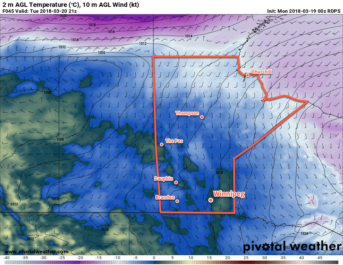
Tuesday will bring more cloudy skies to Winnipeg with a high near 0°C. The Red River Valley will continue to see a chance of light snow as the upper trough exits the province. All snow – if there is any – should taper off on Tuesday night as temperatures head to a low near -7°C.
Temperatures will climb above the freezing mark in Winnipeg on TuesdayWednesday will bring…more cloud to Winnipeg. Light winds over the coming 3 days will do very little to move the extensive area of cloud out of the region. So, under mostly cloudy skies Winnipeg should reach a high near +1 or +2°C. With more cloud around on Wednesday night, temperatures should dip to a low near -7°C yet again.
Long Range Outlook
Little change is forecast through the remainder of the week. Fairly cloudy conditions will remain in place, but temperatures will warm just a tad with highs climbing into the +3 to 5°C range. The weekend continues the cloudy prognosis, with increasing chances for light snow.
Winnipeg’s seasonal daytime high is currently 0°C while the seasonal overnight low is -10°C.
Winnipeg will see variable cloudiness and near-seasonal temperatures through the remainder of the work week.
Winnipeg will see pleasant days ahead despite slightly below-seasonal temperatures. The city will see variable cloudiness today and tomorrow as the last remaining cloud from Monday’s storm system drifts eastwards through the region. No snow is expected. Winnipeg should see high temperatures near -5 or -4°C and overnight lows dipping as cold as -15°C.
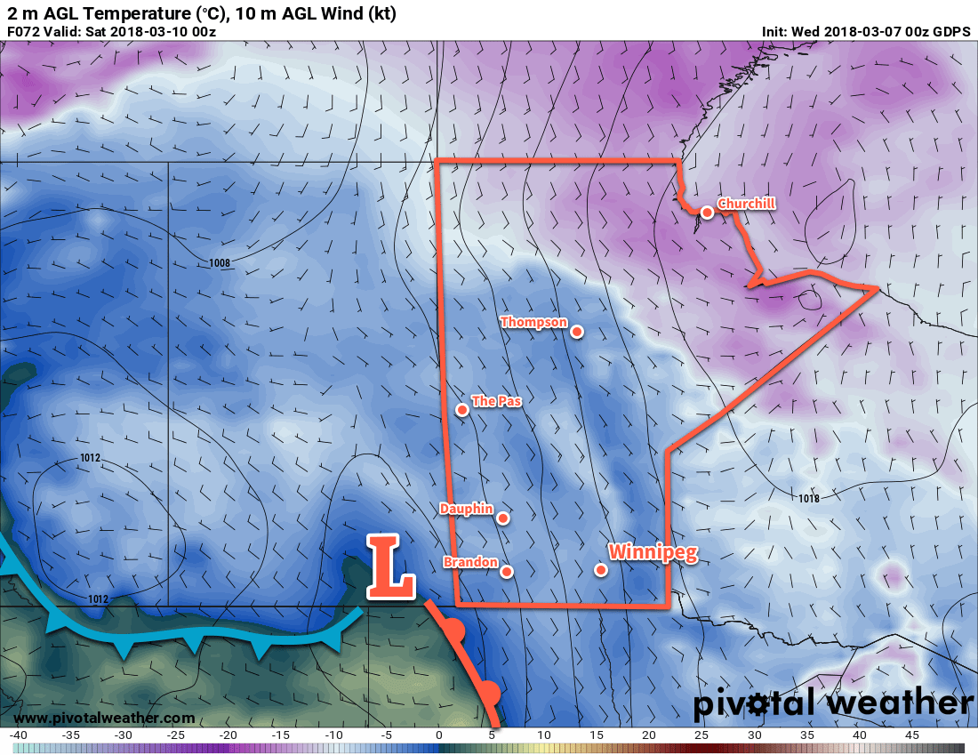
A low pressure system will be just west of the Manitoba border by Friday evening
Friday may start with a bit of sunshine, but cloud is forecast to begin moving in early in the day as a low pressure system approaches from Saskatchewan. Winds will pick up out of the southeast to around 20 to 30 km/h. Temperatures will reach a seasonal -3°C for a high, then dip down to about -6°C overnight under cloudy skies. The chance for light snow will increase after midnight as the low moves into Manitoba.
Long Range Outlook
Saturday morning will likely bring a bit of light snow to the region with accumulations of 2 to 3 cm possible. The snow will taper off as the low pressure system passes and winds switch to northwesterly. Mild temperatures will remain in place for Saturday, the near-seasonal temperatures return for Sunday.
Next week is looking fairly dry with a fair amount of sunshine. Temperatures should return to slightly above-seasonal values, with several days above-0°C days possible!
Winnipeg’s seasonal daytime high is currently -3°C while the seasonal overnight low is -13°C.
Snow will gradually taper off today as Winnipeg digs out of the biggest snow storm of the 2017/18 winter season.
The long-advertised winter storm has finally moved into the Red River Valley, bringing a variety of winter weather with it. Everything started off yesterday evening as rain and ice pellets moved into Manitoba from North Dakota. As the precipitation intensified, the rain switched over to heavy snow. In some places, notably near Letellier and west of Winnipeg, people got to experience the rare1 phenomenon known as thundersnow. Heavy snow set up along a southeast to northwest band that remained stationary for much of the night. Winnipeg found itself right under that band, and so far has seen as much as 15 to 20 cm of snow, with snow still falling in some parts of the city.
Manitoba highway closures valid at 6:15 AM CST
Manitoba Hydro power outage map valid at 6:15 AM CST
This storm has had significant impact on southern Manitoba. Through Sunday evening, many area highways began to close as the snow piled up and conditions became quite treacherous. As of 6:15 this morning, most major highways still remain closed. Additionally, the wet, heavy snow has resulted in power bumps or outages throughout Winnipeg and the Red River Valley. Manitoba Hydro’s power outage map shows a rather extensive area where the overnight snow has impacted the power grid.
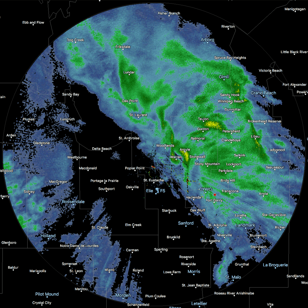
Woodlands RADAR shows the main band of snow running northwest-southeast with Winnipeg right on the southern edge.
Periods of snow will continue today as it streams northwestwards through the region. At times where Winnipeg may find itself outside the bands of snow moving through, there will be a slight chance of freezing drizzle. In Winnipeg, the snow should taper off by mid-to-late afternoon as drier air begins moving westwards from Ontario. The snow will continue over the western Red River Valley well into the evening, so travellers will still need to give themselves time and drive carefully if heading west once the highways re-open.
Temperatures will continue to be mild today with a high near 0°C. Winds will continue out of the east around 30 gusting to 50 km/h for the rest of the day. The chance for snow will taper off this evening, as will the winds. The clouds will begin to break up sometime after midnight as temperatures head to a low near -12°C.
Tuesday will bring mixed skies with some gradual clearing towards sunnier conditions in the afternoon. Temperatures will be near-seasonal with a high near -5°C. The winds will be lighter too at about 15 km/h out of the northeast. More clouds will move in overnight as the inverted trough that has been anchored near the Saskatchewan/Manitoba border begins shifting eastwards. Expect a low near -14°C on Tuesday night.
Wednesday will bring the inverted trough back through Winnipeg, bringing mostly cloudy skies and a chance of flurries as it moves through. Temperatures will remain similar to Tuesday with a high near -5°C and low overnight near -13°C. Winds will be light as the trough moves through.
Long Range Outlook
The remainder of the work week will bring variable cloudiness with temperatures climbing back towards 0°C for the weekend. A disturbance moving through at the end of the week may bring another batch of snow to Winnipeg. Forecasts currently show the possibility of 2-5 cm Friday night into Saturday morning. After that moves through, the weather looks fairly quiet with mild temperatures.
Dig out, enjoy the winter wonderland, and get ready for slush and puddles by the end of the week!
Winnipeg’s seasonal daytime high is currently -4°C while the seasonal overnight low is -14°C.
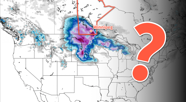
Winnipeg is on track to see an unsettled weekend culminate in a major winter storm as a Colorado Low spreads heavy snow into Manitoba on Sunday night. But the big question remains: how much?
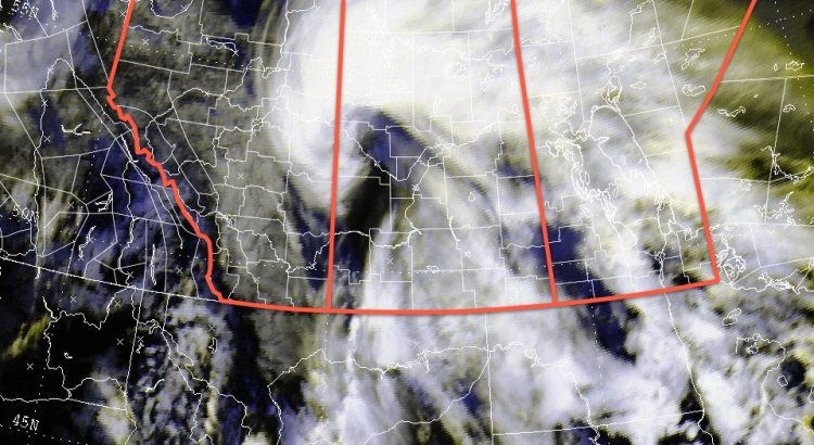
Those hoping that we could escape winter without a major storm this year, brace yourself. It all kicks off today with cloud building through southern Manitoba as a complex storm system begins organizing over the western United States. Temperatures in Winnipeg will be mild with a high near -2°C. Winds will remain light out of the northeast. As some warmer air lifts northwards through the Dakotas towards Manitoba in the evening, it will begin bringing the chance of snow to the region. Temperatures should remain steady near -3°C on Friday night.
The uncertainty begins to ramp up on Saturday with models providing a variety of possible solutions. The general agreement as of writing is that snow will spread across southern Manitoba through the day on Saturday, with more organized snowfall developing on Saturday night. Amounts with this first batch of snow will be limited, with general amounts of 2 to 4 cm forecast on Saturday night. Temperatures will be quite mild on Saturday with a high near +1°C, which means that if precipitation moves into the Red River Valley through the day, some if it may fall as rain. Winds will be out of the east-northeast at 20 to 30 km/h.
Snow will be possible across much of southern Manitoba on Saturday as a line of snow lifts northwards.
Mild temperatures will continue Sunday with highs once again near 0°C. There will be a slight chance of flurries or drizzle through the day as a Colorado Low begins lifting northwards. Winds will continue out of the north near 30 km/h. The main event is forecast to begin on Sunday evening as heavy snow moves into the province from the south. Unfortunately, there is still quite a bit of uncertainty associated with this, including:
Where will the heaviest bands of snow set up?
How quickly will this system move?
Exactly how intense will the snowfall be?
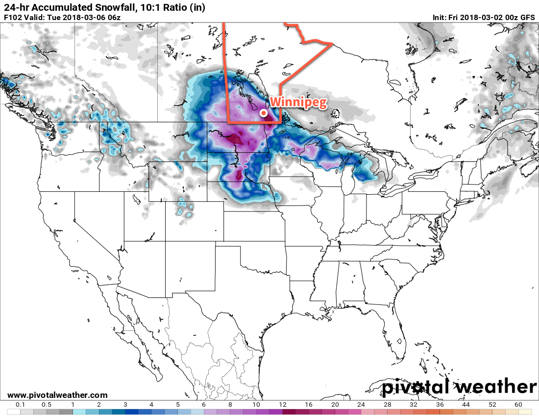
For Sunday night, it looks like the main threat areas are the Red River Valley west towards the Saskatchewan border. There’s a lot of uncertainty with how fast the snow will push northwards, but reaching the Trans-Canada corridor by Monday morning looks likely. The snow will be heavy with the potential for 10 to 20 cm overnight. Winnipeg may escape much of this, instead receiving most of the heavy snow on Monday.
One potential snowfall outcome has up to 30 cm of snow in the Red River Valley from Sunday night through Monday. But it’s just ? at this point…
The heavy snow will continue through Monday and then is forecast to taper off Tuesday evening. Storm-total snowfall from Saturday through Monday will likely fall into the 15 to 25 cm range, but there is a small chance of seeing amounts as high as 30 to 40 cm if a worst-case scenario occurs. Either way, it will easily claim the title as worst winter storm so far this year.
Travel Impacts
There will be 3 primary travel impacts from the worst of this storm:
Deteriorating road conditions as snow accumulates.
Reduced visibility in snow and blowing snow.
Snow drifts developing on roadways.
These three elements will be out in full force Sunday night into Monday, and will likely make travel extremely difficult if not impossible. If you currently have travel plans for Sunday night or Monday, it would be a good idea to make a contingency plan and prepare for delays.
Weekend Update
It cannot be understated that the predictability associated with this system is low at this point. We’ll be posting an update or two through the next couple days leading up to the event with updated forecast information, so stay tuned.
Winnipeg’s seasonal daytime high is currently -5°C while the seasonal overnight low is -15°C.