Winnipeg likely won’t escape snow a second time; a low pressure system moving through the province will spread accumulating snow across southern Manitoba this weekend.
Unfortunately, those missing the sun won’t find much relief in the days ahead. Cloud cover will continue to smother the Winnipeg area in the days ahead with only limited opportunities for the sun to shine through.
For today, skies will stay cloudy as a weak disturbance tracks by north of the region. Temperatures will climb to a high in the -5 to 0 °C range with light southwesterly winds. There is a chance of flurries in Winnipeg; the main snow associated with this system will pass through the Interlake, but the Winnipeg area could get clipped by the southern edge. A couple centimetres are possible in the southern Interlake with less than a centimetre likely in the northern Red River Valley.
The cloud cover may break up a little bit overnight as light northwest winds move into the region. Temperatures will dip down into the -10 to -5 °C range by Saturday morning.
A ridge of high pressure will move across the region on Saturday. Some sunny breaks are possible, but the next low moving towards the area will spread more cloud into the Red River Valley later in the day. Winds will be light with a high around -5 °C. Some light snow could push into the area in the second half of the night.
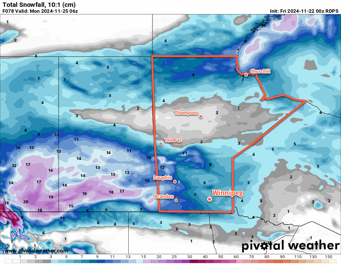
An upper disturbance will track across the southern Prairies on Sunday and support an inverted trough that will build into Manitoba. This will spread a large area of snow across Saskatchewan on Saturday and Manitoba on Sunday. The heaviest snow will fall in Saskatchewan, where as much as 15 to 25 cm will fall across central and eastern portions of the province. In manitoba, the Parkland and Interlake will likely see 10 to 25 cm of snow, while areas along the Trans-Canada Highway corridor receive 5 to 10 cm. Amounts will diminish into the 2 to 5 cm range further south towards the international border. In Winnipeg, over 5 cm is likely to fall by Sunday evening.
Aside from the snow, temperatures will climb to a high just over -5 °C with light northeast winds. Temperatures will dip down into the -10 to -5 °C range overnight with a continued chance of flurries overnight.
Long Range Outlook
Winnipeg will get a break from the snow on Monday morning, but some more snow is likely to develop Monday afternoon as northerly winds move into the region. In addition to general light snow, areas in the lee of Lake Winnipeg and Lake Manitoba will likely see some lake-effect snow through the afternoon hours.
The cloud cover will start to break up on Monday night, leading into the return of some sun for the middle of next week. The return of some sunshine will be driven by colder air that will continue to filter into the region all week. Daytime highs are likely to fall into the -15 to -10 °C range with overnight lows dipping into the -20 to -15 °C range, bringing the first real push of wintery air into the region this year.
Today’s seasonal daytime high in Winnipeg is -4 °C while the seasonal overnight low is -12 °C.