A Breezy Break from the Arctic Chill

Winnipeg will see variable cloudiness over the next several days with breezy conditions while the city is given a brief reprieve from unseasonably cold temperatures.

Today will be a considerably more pleasant day in Winnipeg than yesterday was, with a much warmer high near -8°C this afternoon as a weak low moving into the Interlake ushers a seasonal air mass into the region. Winds will be a bit breezy out of the south this afternoon, strengthening to around 20 to 30 km/h and producing wind chill values in the -15 to -20 range. This will still be much more pleasant than the -35 wind chills Winnipeg saw for much of Thursday. Winnipeg should see plenty of sun through the first half of the day, but clouds will begin moving into the region in the afternoon as the low approaches, with skies becoming cloudy by mid-afternoon. Expect cloudy skies on Friday night with just a slight chance of some non-accumulating light snow. Winnipeg should see a low near -15°C.

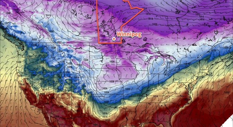
Saturday will see skies clear out early in the morning with temperatures recovering to a high near -10°C. Winds will be breezy out of the west at around 30 gusting to 50 km/h, creating wind chill values near -20. The Arctic front will slump back southwards on Saturday evening, bringing more cloud to the region as temperatures drop to a low near -21°C. There will be just a slight chance of some non-accumulating light snow on Saturday night.

GDPS 2m Temperature Forecast with Annotations valid 12Z Sunday February 18, 2018
Winnipeg will find itself north of the Arctic front once again on Sunday morning.

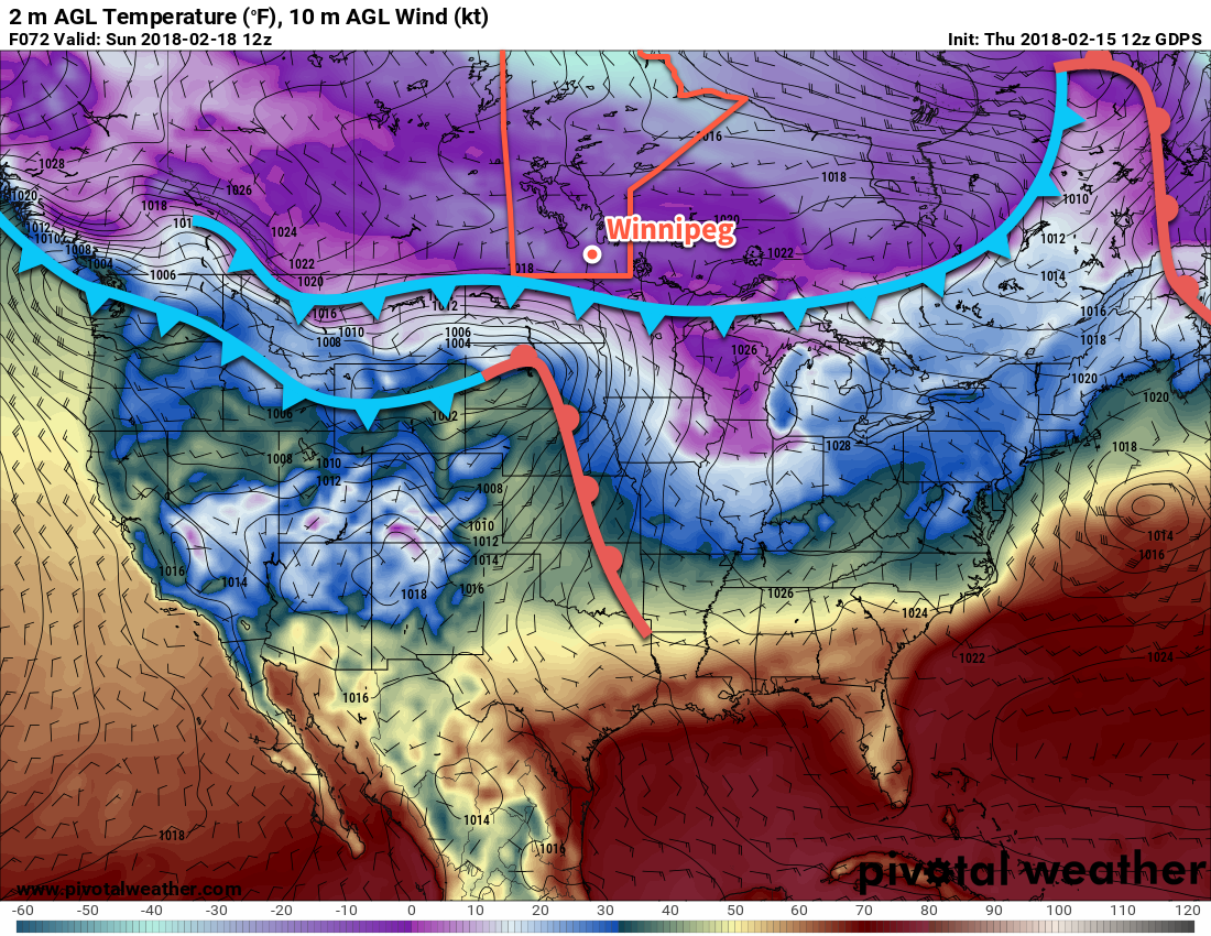
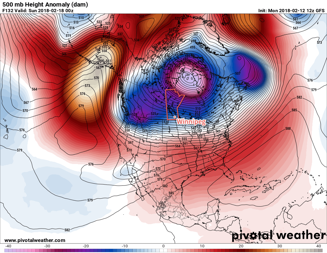
With Winnipeg behind the Arctic front once again on Sunday, temperatures will be well below seasonal with a high near -17°C. Any cloud left in the region should clear out midday, and winds will be out of the north at around 10 to 15 km/h, creating wind chill values near -25. With clear skies much of Sunday night, temperatures will drop to a well below-seasonal low near -25°C.

Long Range Outlook

In what is becoming a notable trend, Winnipeg’s long-range forecast continues to lack any significant precipitation, with nothing more than a trace of precipitation forecast in the next 7-10 days. Passing systems will bring some cloud to the region, but generally speaking, things will remain dry. Below-normal temperatures will likely persist into the middle of next week, but then a trend towards more seasonal temperatures is expected.

Winnipeg’s seasonal daytime high is currently -8°C while the seasonal overnight low is -18°C.

RDPS Forecast 2m Temperature valid 18Z Wednesday February 14, 2018 - Featured

One Mild Day, Then Arctic Air Surges Southwards

Temperatures will climb to the freezing mark in Winnipeg today before two cold fronts surge southwards and bring Arctic air back to the region tonight.

A passing low pressure system will bring significantly milder temperatures to southern Manitoba today as it draws a Pacific-sourced air mass eastwards across the Prairies. Under cloudy skies and much calmer southerly winds, temperatures will climb to a high around 0°C. Winds will become light in the afternoon as the low centre and cold front move through, then pick up out of the northwest to 30-40 km/h as much colder air collapses southwards through the region.

RDPS Forecast 2m Temperature valid 18Z Wednesday February 14, 2018
Winnipeg will see its warmest temperatures midday, then two cold fronts will drop southwards through the afternoon and evening bringing Arctic air back to the region.

There won’t be much chance for snow before the cold front moves through, but once it does in the late afternoon, there will be a good chance of some light snow through the remainder of the afternoon and the night. Temperatures will plummet to a low near -22°C with wind chill values in the mid-minus thirties.

RPDS 24hr. Snowfall at 10:1 SLR valid at 12Z Thursday February 15, 2018
The Red River Valley will likely see just a dusting of light snow as the cold fronts move through Wednesday evening through Thursday morning.

Conditions will settle through the remainder of the week. Thursday will see clouds clear out with a slight chance of some early morning flurries. It will be a cold one again as southern Manitoba find itself once again behind the Arctic front; Winnipeg will see a high near -19°C. Winds will continue near 30 gusting 50 km/h through the morning, finally tapering of in the late afternoon, so wind chill values will remain an issue much of the day, hovering in the -30 to -35 range. The wind will taper off Thursday night with lows dipping down to around -23°C, moderated slightly by warmer air that will begin working into the region through the second half of the night.

Friday will be a pleasant day with south-southwesterly winds around 20 km/h and a high near -11°C. Winnipeg should see plenty of sun with clouds not moving into the region until the late afternoon as another low approaches from Saskatchewan. There will be a chance for some light snow on Friday night with cloudy skies and a low near -15°C.

Long Range Outlook

The long-range outlook for Winnipeg is…more of the same. Near-seasonal temperatures Friday and Saturday will likely give way to colder Arctic air again on Sunday, then another gradually climb back towards seasonal temperatures is forecast to take place through next week. Best indications are at this point are for variable cloudiness and relatively light winds with no notable snowfall through next week.

Winnipeg’s seasonal daytime high is currently -8°C while the seasonal overnight low is -19°C.

Slow, Windy Climb In Temperatures Will Come Crashing Back Down

Winnipeg will embark an on a windy climb to well above-seasonal temperatures by Wednesday, but the warmth will be short-lived as Arctic air comes crashing back southwards for the second half of the week.

Winnipeg will see cool temperatures today under sunny skies as a ridge of high pressure moves off to the southeast and out of the region. Winds will be out of the southwest at 20 km/h for much of the day, then strengthen to 30 km/h this evening. That wind will produce wind chill values of -25 to -30, so that cold will have a bit of bite to it. Skies will remain mostly clear tonight with winds slowly climbing to 40 km/h overnight.

Tuesday will bring partly cloudy skies to Winnipeg and milder temperatures, but the wind will be the main story for the day. As the pressure gradient tightens up between a low pushing southwards out of the Arctic and the departing high, winds will strengthen further on Tuesday to as high as 50 gusting 70 km/h out of the south. Those winds will make the day’s high near -6°C a whole lot less pleasant than it would otherwise be. Some local blowing snow is also possible, but likely in the usual trouble spots in rural portions of the Red River Valley. The cloud will thicken up on Tuesday night with temperatures dipping to just 8 or 9°C.

Windy conditions will be in place for Winnipeg on Tuesday afternoon.

Wednesday will bring the warmest conditions of the week as very mild Pacific air moves through the region and pushes temperatures up to around -1°C. The warmth will be short-lived though; winds will shift out of the northwest in the afternoon as the first of two cold fronts swings through. The cold front associated with the Pacific air mass will push through midday, followed by the Arctic cold front in the evening. This will send temperatures from their high of -1°C sometime Wednesday morning plummeting to a low near -26°C on Thursday morning. Wind chill values will also begin to approach the -40 mark on Wednesday night, so extreme cold warnings may make another appearance across the region.

Other than the temperatures, Winnipeg will see cloudy skies on Wednesday with a slight chance of flurries in the afternoon, after the Pacific cold front swings through. That slight chance will continue through the evening hours. No notable accumulations are expected.

Long Range Outlook

The overall long-range pattern continues to be dominated by the position of the polar vortex. With the passage of Wednesday’s system, it will shift westwards from Baffin Island towards Southampton Island, shifting the core of coldest air into the Kivalliq region of Nunavut, along the western shores of Hudson Bay. As long as the polar vortex remains in that location, colder-than-seasonal weather will be the norm as the vortex maintains a northwesterly flow aloft that makes it easy to tap into all the cold air and spread it southwards over the Prairies.

The polar vortex will remain anchored over Southampton Island for much of next week with the Prairies seeing occasional weak systems rotate through along its southern flank.

Early indications are that temperatures may return to above-seasonal late this week as another low pressure system moves through the region, bringing with it a chance for some accumulating snow, but then the cold air crashes back southwards behind the low. The colder air looks like it will remain in place for much of next week.

Winnipeg’s seasonal daytime high is currently -8°C while the seasonal overnight low is -19°C.

Cloudy, Slightly Warmer Weekend Ahead

A series of low pressure systems moving through Manitoba will bring cloudier conditions this weekend alongside slightly milder temperatures.

Before the cloud arrives, today will bring another sunny day to Winnipeg with temperatures reaching a high near -14°C with winds picking up out of the southwest to 20 to 30 km/h this afternoon. Winds will ease tonight to around 10 km/h with increasing cloud cover as temperatures dip to a low near -21°C.

Skies will cloud over on Saturday with a chance of flurries as some slightly warmer air pushes in from the northwest. Highs should climb to around the -12°C mark, then fall to around -18°C on Saturday night with an increasing chance of seeing some light snow.

Sunday will bring cloudy skies to Winnipeg with a good chance of some light snow in the morning. Temperatures will climb to around -12°C again, but clearing skies in the evening will allow temperatures to dip back down to around -23°C for a low on Sunday night. Winds will switch from the southwest to the northwest midday as a low pressure system passes, picking up to around 30 km/h for a few hours in the afternoon. The winds will ease to light on Sunday night.

Long Range Outlook

The long-range forecast continues to look fairly dry with little significant changes on the horizon. Temperatures next week look variable between near-seasonal and below-seasonal, and other than a chance for some light snow on Wednesday, the forecast looks fairly dry.

Winnipeg’s seasonal daytime high is currently -9°C while the seasonal overnight low is -20°C.