Saturday Brings First Snowfall of the Season

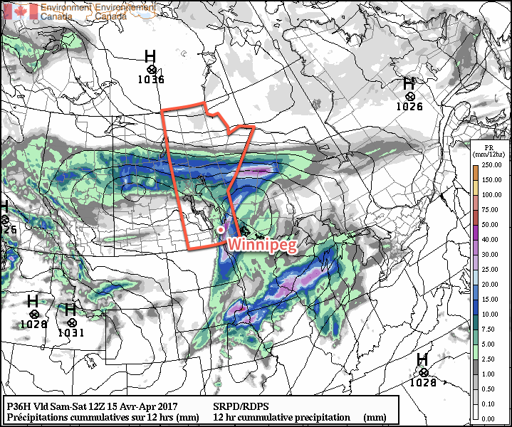
A low pressure system tracking along the U.S. border will bring a mix of rain and snow to southern Manitoba on Saturday, and while the Red River Valley may see a few slushy centimetres, higher accumulations of 5 to 10 cm will be possible over the southwest corner of the province. The snow will be short-lived, however, as above-seasonal temperatures are set to return next week!

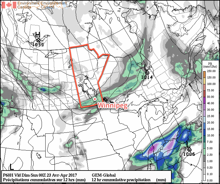
Models took a quick turn after our Wednesday forecast with a dry weekend quickly turning…not so dry as they picked up on a disturbance that will track along the US border and likely bring rain and snow to southern Manitoba on Saturday. Before that, though…

Today will be a cool but beautiful day! Winnipeg will see sunny skies and westerly winds at around 15 to 25 km/h as temperatures climb to a high near 10°C. Cloud will begin pushing into the Red River Valley tonight, bringing a chance for some rain showers to Winnipeg before morning. Winds will be calm as temperatures dip to a low near 2°C.

3km NAM Forecast Precipitation Type and Intensity valid 18Z Saturday October 14, 2017
Rain showers will give way to snow from northwest to southeast across the Red River Valley on Saturday. Winnipeg will likely see the changeover occur midday.

Southern Manitoba will see a mix of precipitation through the day on Saturday. The biggest question of the day will be where the rain/snow line will set up, and right now it appears that Winnipeg will straddle that line, with a few morning showers either mixing with or changing over to snow midday. Fortunately, with near-zero temperatures, any snow will be unlikely to accumulate too much through the city, with just a slushy couple centimetres possible. Further to the west and north, more substantial snowfall is possible, with 5-10 cm possible along a line from around Estevan, SK to Virden, MB to Lake Manitoba.

We’ll definitely post an update later tonight with a revised snow/rain forecast for Saturday.

Aside from the precipitation, expect to see temperatures climb to a high just near 5°C with northeasterly winds of 15 to 25 km/h. Temperatures will dip down to around -2°C with some clear breaks overnight.

Sunday will see conditions improve, with mixed skies and a light west-southwest wind as temperatures climb to a high near 10°C. Temperatures will drop to a low slightly above freezing.

Long Range

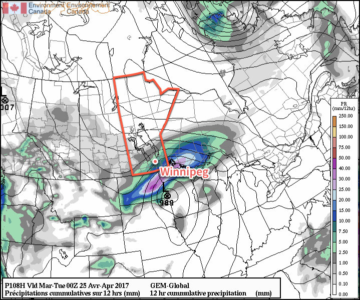
Next week is looking fantastic for those who aren’t quite ready for the latter parts of fall. Warmer air is expected to spread eastwards across the Prairies, and while there may be a disturbance or two with a brief cool-down associated with it that moves through, temperatures will tend to remain above-seasonal.

GDPS 850mb Temperature Anomaly valid 06Z Friday October 20, 2017
Very mild air will spread eastwards across the Prairies through next week, with significantly warmer-than-seasonal temperatures (red, brown) possible at the end of the work week.

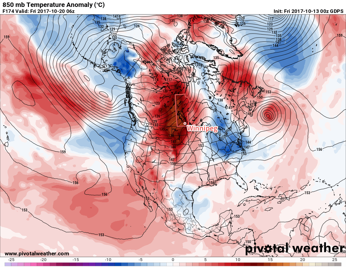
Daytime highs in the mid- to upper-teens will be common through the week, alongside variable cloudiness and few chances for rain as the main storm track appears to remain in the central and northern Prairies.

So make it through a bit of an unpleasant Saturday, and a beautiful mid-October week lies ahead.

Winnipeg’s seasonal daytime high is currently 11°C while the seasonal overnight low is 0°C.

Winter Storm Brings Snowy Monday to Southern Manitoba

A developing winter storm will bring moderate-to-heavy snowfall to southern Manitoba beginning early Monday morning. The storm system will primarily affect the Red River Valley and areas east, bringing a fair amount of wet, heavy snow to the region.

Monday’s main story will the snow that moves across the region, supported by a developing low pressure system lifting northeastwards through the Dakotas. The area of snow will rapidly develop overnight, first across western North Dakota, then expanding quickly northwards.

The snow will fall throughout much of the day in the Red River Valley, and into the evening over southeastern portions of the province. It will fall mainly as snow, except for the far southeastern portion of the province—particularly in the Sprague area—where it may become mixed with ice pellets or rain as warmer air wraps in just north of the low.

AWM Snowfall Outlook for Monday April 24, 2017

By the time the snow tapers off this evening much of the south-central and southeastern portion of the province will see between 5-10 cm of snow. The Whiteshell region will likely see 10-15 cm of snow.

Potential Forecast Issues: There are a few potential sticky spots for the forecast. The first hinges on temperatures, which are largely expected to be hovering near the freezing mark. If things end up a bit warmer, snowfall totals will be reduced, either due to lower snow-to-liquid ratios and increased melting/compaction of the snow, or via greater mixing of rain. If temperatures end up dropping a bit cooler than expected, snowfall amounts will bump up a bit, but the greatest impact would be in Sprague, which would go from “near 10 cm with mixed precipitation” to “10-20 cm of heavy snow.”

The most likely snowfall amount for Winnipeg is likely in the 7-10 cm range, with a very small chance of creeping up to 11 or 12 cm. While this may seem like a pretty notable snow, it’s not very significant in the grand scheme of things and doesn’t even register on the top 10 largest daily snowfalls after April 15th:

Top 10 Largest Daily Snowfalls After April 15 (Winnipeg 1872-2016)

RankSnowfall AmountDate
121.1 cmMay 1, 1967
220.8 cmApril 27, 1966
320.3 cmMay 19, 1931
420.0 cmMay 9, 2002
520.0 cmMay 11, 2004
617.3 cmApril 24, 1937
716.5 cmApril 25, 1960
815.2 cmMay 20, 1882
914.0 cmApril 19, 1996
1013.0 cmMay 5, 1938
Snowfall records produced by Rob's Obs.

Winds will pick up out of the northeast early Monday to around 30 km/h and remain at that strength for quite a while, gradually shifting to the north by Monday evening and then persisting through Tuesday until tapering off on Tuesday night. Temperatures will drop to a low near -3°C on Monday night, climb to a cloudy high near +3°C on Tuesday and then drop back to a low near -6°C under mixed skies on Tuesday night.

The cloudy skies and cooler temperatures will slow the snow melt over the region, and as a result the snow will likely stick around longer than Friday’s snowfall did. However, the sun should poke a bit on Wednesday which, when combined with a slightly warmer high near 4°C, should be enough to melt the snow.

We’ll be keeping an eye on new runs of weather models as they roll in later tonight and update this post if there’s a significant shift in the snowfall forecast.

Long Range

Cooler-than-normal temperatures will persist through the remainder of the week with daytime highs of 5-9°C remaining below the seasonal average of 14-15°C.

Winnipeg may see some more rain or snow on Thursday as a large low pressure system lifts into Northern Ontario and may spread precipitation westwards into Manitoba; this seems relatively unlikely, but it’s worth being aware of as an outside possibility.

Things should settle down for the weekend with a return towards seasonal temperatures, however long range models show the potential for another system Sunday night into Monday that could bring more rain and snow into the region.

Winnipeg’s seasonal daytime high is currently 14°C while the seasonal overnight low is 1°C.

One More Day of Warmth Before A Big Cool Down

Winnipeg and the Red River Valley will see mild temperatures today, but a sharp cold front will sweep through the early Saturday, bringing unsettled conditions and much cooler temperatures.

A southwesterly flow aloft will draw mild air into the Red River Valley today, eventually sending daytime highs into the mid-teens this afternoon. Before that, however, there will likely be fog patches throughout much of Southern Manitoba. Areas that see fog will likely see some cloudier skies through the morning as the fog lifts, but it should subsequently burn off leaving much of the region under sunny skies. Winds will also be light, so all in all it should be a beautiful day.

Change is afoot, though. Cloud will move in overnight as a cold front slumps southwards through the province. It will move through very early on Saturday morning, ushering in northerly winds to around 30 gusting 50 km/h and sending temperatures to a low near +2°C. As the front moves through in the morning, it will support an area of precipitation that will begin as rain, but possibly change over to snow mid-morning.

The GDPS is forecasting a swath of 2-5 mm of precipitation across southern Manitoba on Saturday.

The precipitation will end midday as winds begin to ease and temperatures climb to a high near 6°C. There’s a decent chance that the cloud cover will break up a bit in the afternoon let the sun shine through. The wind will diminish on Saturday evening as the temperature drops to a low near -2°C with some cloud cover beginning to move in.

Sunday will bring mixed skies to the region as Saturday’s disturbance departs and the next one develops in Alberta. A reprieve from precipitation, temperatures will climb to a high near 6 or 7°C with light easterly winds. Cloud coverage will increase in the evening as the next system approaches, bringing with it a chance of showers for Sunday night. Temperatures will drop down to a low near 0°C.

Long Range

The start of next week will bring more unsettled weather as a major storm system tracks near the American border. Uncertainty exists on the track of the low, and with a fairly sharp boundary to its precipitation, that leads to a wide range of potential precipitation amounts.

The GDPS clips Winnipeg with a major system that tracks along the American border early next week.

We’ll have updates closer to the event on what exactly we can expect from this system.

In the wake of that low, Winnipeg and the Red River Valley will see a stretch of calm weather with below-normal temperatures until the end of the week, when another system may impact the region and bring more rain and/or snow to the province.

Winnipeg’s seasonal daytime high is currently 13°C while the seasonal overnight low is 0°C.

Unsettled Slide Back to Chilly Conditions for the Easter Weekend

Temperatures will fall off a cliff this weekend from nearly 20°C today to barely above freezing by Sunday as a surge of cold air plows southwards in the wake of a winter storm moving across the central and northern Prairies. This push of colder air will also bring unsettled conditions to Winnipeg & the Red River Valley, with several chances for rain and even a slight chance of flurries towards the end of the weekend.

Winnipeg will see warm and windy weather today as a low pressure system tracking through the central & northern Prairies moves into eastern Saskatchewan. A warm front associated with this system will move through this morning, bringing a slight chance of showers to the region. Temperatures will then climb to a high near 18°C with strong southerly winds increasing to 40 gusting 60 km/h. A cold front will push eastwards into the Red River Valley this afternoon, triggering the development of a line of showers that will move through the valley late in the afternoon into the evening. Along with the rain, there will be a slight chance of an isolated thunderstorm or two along this line of showers.

Portions of the Red River Valley could potentially see over 25mm of rain in the [thunder]showers that move through Friday evening

By 10 or 11PM, the rain should be moving off east of the Red River Valley, and Winnipeg will head towards a low near 6°C with gradual clearing and diminishing winds.

Saturday will actually be a relatively nice day for much of the day. The Red River Valley will be nestled between Friday’s cold front to the east and a second cold front approaching from the north. That said, temperatures will climb to a high near 13 or 14°C with fairly light winds and variable cloudiness. A second disturbance will move into the region late in the afternoon, dragging another cold front southwards into the Red River Valley that will bring another wave of showers to Winnipeg & the Red River Valley. These showers will gradually taper off overnight, but temperatures will be dipping down to a low near +1°C, and those rain showers may change over to flurries in the second half of the night.

Temperatures will be stuck well below-normal (blue) across southern Manitoba on Sunday,

Sunday will be a rather unpleasant day as moderate northerly winds keep the temperature pinned near the freezing mark. Skies will remain cloudy through the day with a chance of flurries. Temperatures will dip down to around -4°C on Sunday night under mostly cloudy skies.

Long Range

Temperatures will slowly rebound towards seasonal through the first few days of next week. Winnipeg may see another chance for showers or flurries on Tuesday, but then things begin to settle down for the second half of the week.

Winnipeg’s seasonal daytime high is currently 10°C while the seasonal overnight low is -2°C.