Milder Weather Ahead, But Deep Freeze Looms

A few morning flurries will mark the arrival of slightly milder air than has been in place over Southern Manitoba over the past several days, however the reprieve will be brief as another potent blast of Arctic air spills southwards for the weekend.

This morning will start off with a few flurries tapering off as a weak disturbance shunts by to the south of Winnipeg, leaving behind mainly cloudy skies for the day. There will be a slight chance of continue flurry activity through much of the day thanks to favourable snow-making temperatures throughout the depth of the cloud cover, but with the lack of any real focus for the snow, it will be very light if it occurs and pose no likelihood of any accumulation. Temperatures will be slightly milder than the highs near the -20°C mark that have been in place over the last few days; today’s high should climb to around -15°C with light southerly winds while the low tonight drops to around -19°C under mostly cloudy skies.

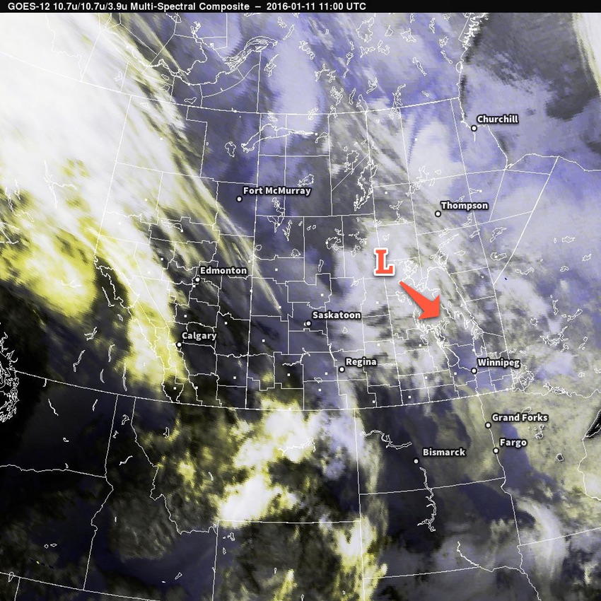
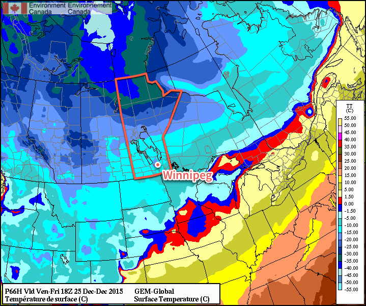
Thursday will bring a pair low pressure system through the province; the first skirting through the southwestern corner and the southern Red River Valley before exiting into Minnesota while the second drops down from Northern Manitoba, eventually merging into the first low near Lake Superior. This makes the forecast a little bit trickier, but fortunately neither system will bring particularly significant weather with it. The southern low will produce a swath of 2-3cm of fresh snow through southwestern Manitoba into the southwestern Red River Valley, while areas to the north and east see some light flurry activity.

RDPS 12hr. Precipitation Accumulation for Thursday
The RDPS is showing the main swath of snow from Thursday’s system well to our south…perhaps too far south.

Winnipeg appears to be near the edge of that, so throughout the day on Thursday we’ll likely see fairly cloudy skies with a chance of some flurries or perhaps even some light snow if the whole system pushes a little further to the east. Temperatures will climb a little higher than today, with a high temperature near -13°C expected.[1] Skies will remain fairly cloudy on Thursday night with a chance of flurries; the overnight low should be near -22°C.

With the low pressure systems off to our southeast, all that will be left is for the Arctic air to begin building back into the region unimpeded. This next shot of cold looks, at this point, to be colder than the last by a couple degrees. Friday will mark the entrance of that air, with northwest winds near 15-20km/h and a high near -19°C under partly cloudy skies. The overnight low on Friday night will sit near a very chilly -28 or 29°C.

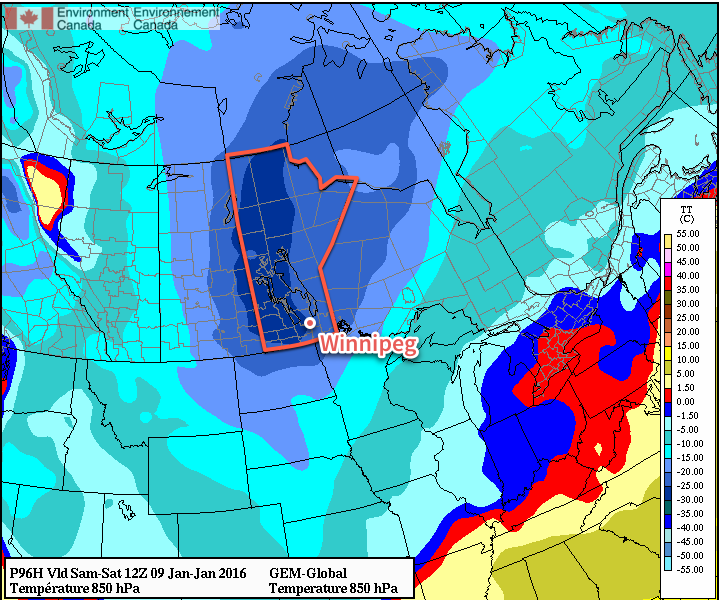
Bitterly Cold Weekend Ahead

This weekend will be particularly cold thanks to a deep Arctic air mass that will slowly move through the region.

850mb Temperature Forecast for January 15-18, 2016
This animation of 850mb temperatures from Friday morning to Sunday morning shows the bitterly cold air moving over the province.

It will begin moving in on Friday, the core of it will be over Winnipeg on Saturday, and then it will begin shuffling off on Sunday. Unfortunately, as these systems move to the southeast, temperatures here at the surface tend to stay quite cold despite the warmer air moving in aloft thanks to an outflow of cold air out of the ridge to our south.

This will mean daytime highs likely around -24 or -23°C this weekend with overnight lows in the -28 to -30°C range. There’s also some indications that there will be 10 to 20 km/h winds through the weekend, which would likely mean Environment Canada would issue extreme cold warnings for wind chill values at night in the -38 to -44 range.

Temperatures will begin to moderate back towards -20°C or the low minus teens early next week.


  1. It’s worth noting that this system will have quite a sharp temperature boundary associated with it, so if everything were to shift east a bit we could see temperatures climbing above -10°C in Winnipeg; conversely, if it were to track further west, we could see daytime highs limited to around -17°C.  ↩

Cold Weather Continues

The cold weather continues in Winnipeg for much of this week with only a brief respite mid-week of some near-seasonal temperatures. Snow-wise, a weak system moving through today will bring a couple centimetres of fresh snow, but otherwise no significant snowfall is in the forecast.

Today’s weather will be dominated by a weak shortwave disturbance sliding southwards through the province. Light snow will push into the Red River Valley from the northwest this morning and taper off this evening. Accumulations will be relatively low with this snow; for the most part, just 1-2cm is expected to accumulate. As the system begins heading past us this afternoon, gusty northwesterly winds to 20-30km/h will develop, making it feel more like the minus 30’s than the high of -20°C.

Multi-spectral satellite imagery of approaching low pressure system.
This morning’s satellite imagery reveals the low pressure system that will slump to the southeast and bring light snow to the region today.

Behind this system, another Arctic ridge will build into the southern Prairies, reinforcing the cold air. Here in the Red River Valley, temperatures will dip to around -26°C tonight with wind chills in the -33 to -37 range. In the southwest corner of the province, temperatures could fall as far as -30 to -31°C, which would result in wind chills near or slightly below -40.

Tuesday will be a fairly quiet day over Winnipeg & the Red River Valley with mixed skies and a high near -20°C. Winds will be fairly light.

The next system moving into the Prairies will spread cloud across Southern Manitoba on Tuesday night, somewhat limiting our overnight low to around -24°C.

3hr QPF from the RDPS valid overnight Tuesday.
This forecast from the RDPS for Tuesday night shows a broad warm front pushing into Manitoba with an area of light snow ahead of it.

Wednesday is a bit trickier, but either way things pan out, the weather won’t be too significant. The big story will be that near-seasonal temperatures will finally move into the Red River Valley with daytime highs climbing into the -13 to -15°C range. Skies will be mainly cloudy.

Depending on how far east the disturbance moving through the region pushes, we may see some light snow through the day. If it remains to our west, as guidance suggests, it seems probable that we could see some very light flurry activity across the region.

Temperatures will remain comparatively mild on Wednesday night with overnight lows near -20°C.

Colder air is set to return for the second half of the week with another shot of sub-20°C high temperatures likely this weekend.

Temperatures Plummet for Weekend Arctic Outbreak

Winnipeg will be re-introduced to winter this weekend as a major pattern shift will usher in one of the coldest outbreaks of the season as bitterly cold air surges out of the Arctic and plummets much of North America into below-normal temperatures.

The next few days will see Winnipeg socked in under extensive cloud cover. While the lack of sun will be a little disheartening, the thick blanket of cloud will moderate temperatures substantially, staving off the cold weather for a little longer.

Both today and tomorrow will be mainly cloudy days with daytime highs around -7 or -6°C and overnight lows in the -10 to -12°C range. A weak ridge of high pressure anchored through the region over the coming days will also keep winds fairly light. All in all, it looks like a relatively pleasant couple of January days.

On Thursday night, a disturbance rippling through the region aloft will help deepen an inverted trough extending to the north-northwest from a low pressure system moving through Iowa. These two things combined will help support an area of light snow that will spread across the province from central Saskatchewan.

AWM Snowfall Forecast for January 7-8, 2016
A large area of light snow is expected to move thorugh the Red River Valley on Friday. Heavier snow is expected through east-central Saskatchewan into Swan River & Dauphin.

Snow will begin through Thursday night from west to east and will be fairly light, with just 2-4cm total accumulation expected by the time it tapers off on Friday afternoon.

Temperatures will be fairly steady throughout the snowfall on Friday, either remaining near Thursday’s overnight low or perhaps recovering just a degree or two. As the snow tapers off in the afternoon, gustier northwesterly winds will build into the region—at this point it looks like they’ll be around 30km/h—and begin ushering in colder air.

Skies will clear on Friday evening allowing temperatures to plunge to about -21°C by Saturday morning.

Long Range: Cold Weekend

This weekend will see bitterly cold weather settle in over the province as the core of the coldest air on the continent rotates over the region. [1]

GDPS 850mb Temperature Forecast valid Saturday 12Z 09 January 2016
The GDPS 850mb temperature forecast shows the core fo the coldest air on the content rotating into Manitoba.

This very cold air mass will result in temperatures steady near around -20°C on Saturday, but quickly dropping into the lower -20’s on Saturday night. Sunday will likely see a high near -21 or -22°C with temperatures remaining fairly steady on Sunday night as some warmer air begins working into the region. Skies will be mainly clear through the weekend with little wind.

Looking further ahead into next week, near-seasonal temperatures to slightly below-seasonal temperatures are expected. Seasonal highs are near -13°C for this time of year.


  1. Some may wonder why the coldest air mass on the content won’t result in the coldest temperatures on the continent, and the answer to that is complicated. The most basic reason is simply that compared to our Arctic neighbours, we actually have sunshine at this time of year. There are a host of other reasons, too, rooted in prior conditions.  ↩

A Seasonal Christmas Ahead; Cold This Weekend

Light snow will taper off and lead towards a seasonal Christmas this year with a chance of flurries, but perhaps one of the strongest shots of cold air seen this winter will move in for Boxing Day.

Light snow will persist through much of today thanks to a persistent area of snow hanging back into the Red River Valley. There will be a bit more accumulation; generally around 2-4 cm will fall today through the valley. The wind will be a bit chilly as it picks up out of the northwest to around 30 km/h with some gusts on top of that; with the fresh snow in place, it will likely be enough to produce localized areas of blowing snow and poor visibilities. With that north wind, we’ll see temperatures fall throughout the day to around -10°C by the evening hours, which will be just a couple degrees warmer than our overnight low of -12°C.

Thursday will see plenty of cloud lingering around in the Red River Valley. Temperatures will be nearly stagnant through the day, rising just a couple degrees by early in the afternoon before beginning to fall again, a casualty of the incoming Arctic air. It doesn’t look like snow will be much of an issue, though, so other than the cool temperatures, the day should actually be alright. Heading into the night, temperatures will drop to around -15°C under mostly cloudy skies.

GDPS forecast surface temperatures for Friday at 18Z
GDPS forecast surface temperatures for midday Friday

Friday, Christmas Day, will be a seasonal day thanks to a weak disturbance forecast to slip across the region, delaying the arrival of the colder Arctic air. With a daytime high of -12°C, temperatures will be nearly right on what’s seasonal for this time of year. A bit of very light snow is likely, but accumulations look to be minimal. Winds will shift around to the north and begin ushering in colder air late in the day. Expect an overnight low on Friday night dipping into the -20’s, likely around -22°C or so with clear skies beginning to develop over the region.

Long Range

The weekend will start with a miniature deep freeze, at least by the standards 2015 has set so far. Saturday will see clear skies and daytime highs struggling to climb even towards the mid-minus teens, likely ending up somewhere between -20 and -15°C. Fortunately, the cold weather will be short lived with a surge milder air returning for Sunday and returning daytime highs close to the -10°C range.

NAEFS 8-14 Day Temperature Anomaly Forecast valid December 31, 2015 to January 7, 2016

Heading into the longer-range, there’s very strong agreement that a return to significantly above normal temperatures will return to the region for the new year. The NAEFS is actually forecasting a significant stretch of daytime highs likely in the -10°C to -5°C range for the first week of January. So just get past this weekend and rest easy knowing that relative warmth is on the way!

The seasonal temperatures for Winnipeg right now are daytime highs of -12°C and overnight lows of -22°C.