It will be a cold week in Winnipeg with below-seasonal temperatures and variable cloudiness.
Although the Polar Vortex will move off to the east, cold air will linger across the Prairies through the week. In an unusual twist, it will briefly warm up in northern Manitoba as Atlantic air wraps westwards over the eastern Arctic and into the region.
The Polar Vortex will sit over eastern Canada this week with a cold trough hanging westwards across the Prairies. As a result, much of the region will see below-seasonal temperatures; fortunately, the ruthless cold that was entrenched over the western Prairies will moderate away from those extreme values.
In Winnipeg, the city will see more light snow today with skies on the cloudier side through Wednesday. Daytime highs will climb into the -15 to -20 °C range with west-northwest winds of 20 to 30 km/h. The snow won’t accumulate too much; the city may see a few centimetres accumulation over the next several days.
Overnight lows will mainly sit in the -25 to -20 °C range. Winnipeg and area will likely see more sunshine in the second half of the week.
Long Range Outlook
Heading into the weekend, the Polar Vortex is forecast to finally shift eastwards out to the Atlantic, weakening the cold air over the Prairies and allowing a more progressive pattern to develop. Upper ridging will build into the Prairies over the weekend, spreading milder air into the western Prairies.
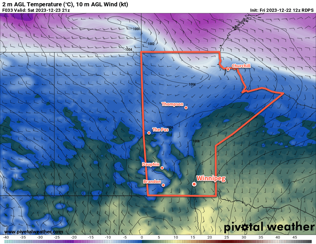
This will help bring temperatures back to seasonal values through the weekend, although will likely bring cloudy skies back to the region.
Next week, skies will continue on the cloudier side, but temperatures will climb to above-seasonal values. Daytime highs will climb back towards the -5 °C mark with lows close to -10 °C.
Today’s seasonal daytime high in Winnipeg is -13 °C while the seasonal overnight low is -24 °C.
Another disturbance moving through Manitoba mid-week will bring another swath of accumulating snow to the region. Behind it, bitterly cold Arctic air will sweep into southern Manitoba.
Many areas will see 10 to 20 cm of snow by the time it tapers off on Friday. The snow will likely be fluffier than this model image depicts and amounts could end up slightly higher than depicted here.
For today, a weak ridge of high pressure moving through the region will bring near-seasonal highs in the mid-minus teens to the Winnipeg area. Light southerly winds will pick up to around 20 km/h in the afternoon, bringing wind chill values of -20 to -30 to the region.
The next weather system of note will begin to push into the region tonight. Cloud cover will spread across southern Manitoba as it pushes a warmer air mass into the region. Light snow will spread across southwest Manitoba overnight and begin to push into the Red River Valley early Wednesday morning. Temperatures will dip into the -15 to -20 °C range in the evening and then warm up closer to -10 °C by Wednesday morning.
2 to 5 cm of new snow is likely through much of western Manitoba tonight.
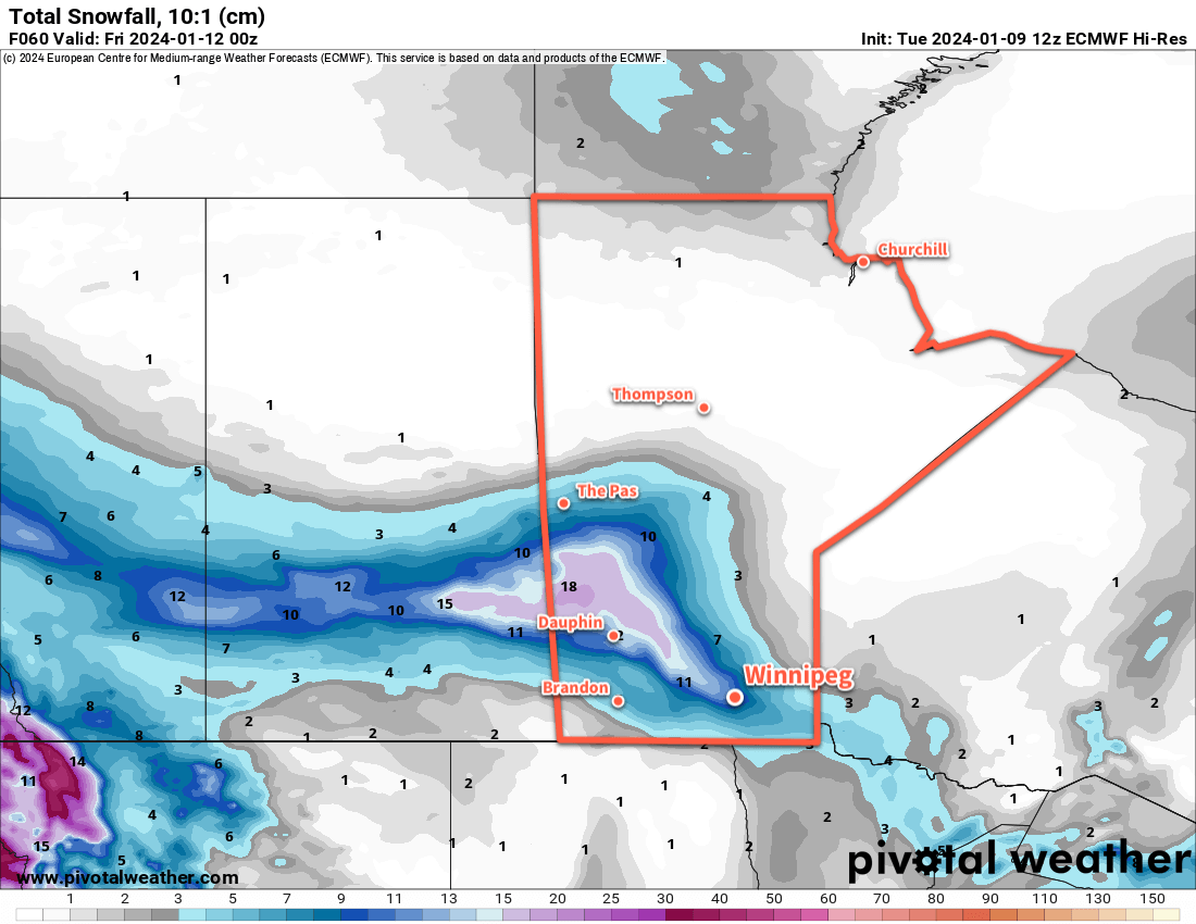
On Wednesday, the low pressure system will drop to the southeast with an inverted trough that lingers to the northwest in its wake. This will support a slow-moving area of light snow that lingers over the Red River Valley through Wednesday and into Thursday. Accumulation rates will be light, but because the snow will linger for a long time, it will result in one of the larger snowfalls of the season.
From Wednesday morning to Thursday morning, 5 to 10 cm of new snow is likely in the Red River Valley, but that number increases into the 10 to 20 cm range to the northwest in parts of Western Manitoba, focused around the escarpment west of Lake Manitoba and Winnipegosis.
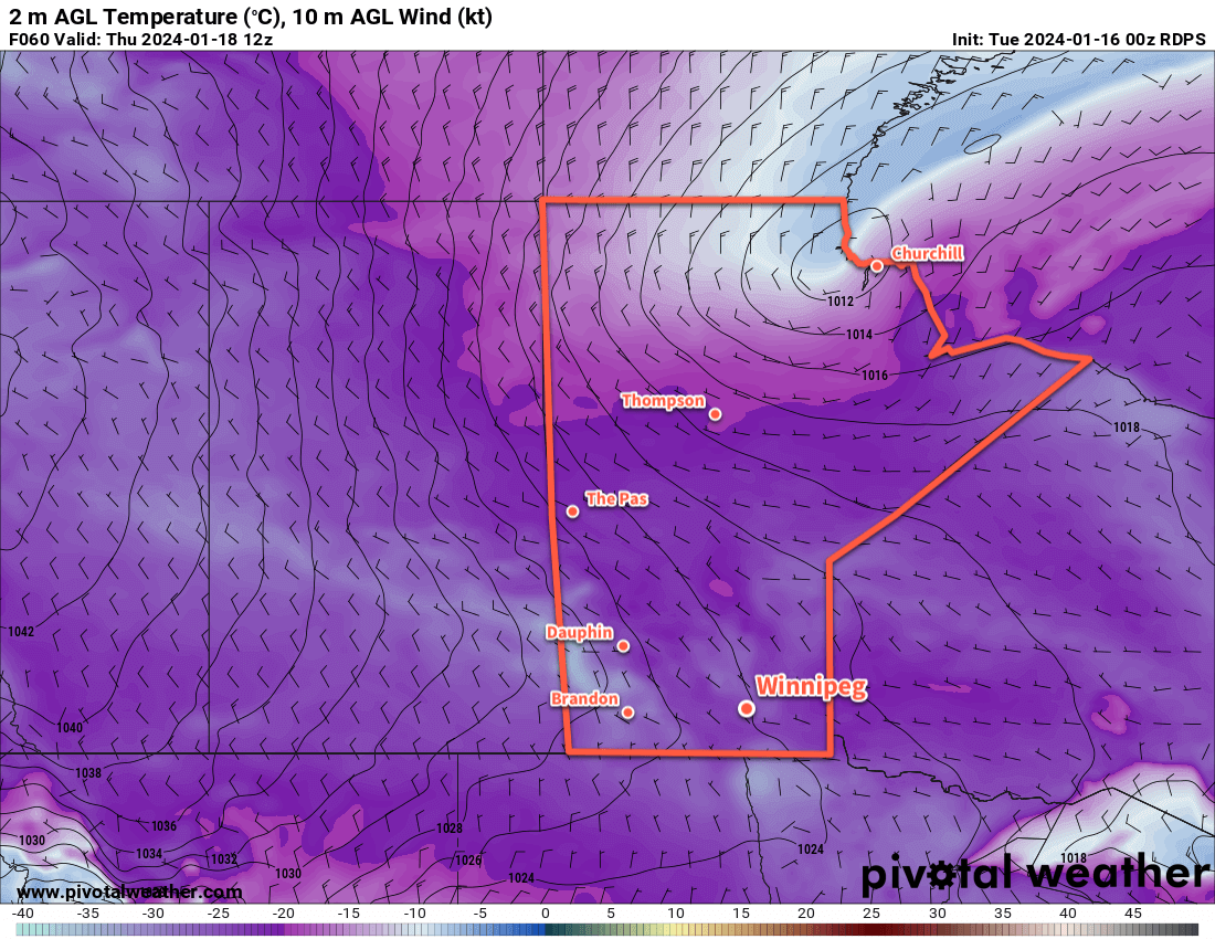
Temperatures will reach a high near -7 °C in Winnipeg on Wednesday, but a cold front will sweep through on Thursday night and mark the beginning of plummeting temperatures.
The snow will taper off later Thursday as northwest winds increase into the 20 to 30 km/h range. Temperatures will fall through the day, reaching close to -20 °C by evening. The cloud cover will begin to break up overnight as temperatures head to a low in the -20 to -25 °C range.
On Friday, the cold air will settle into the region as a large Arctic High begins to push across the Prairies. Winnipeg’s temperatures will climb back into the -20 to -15 °C range with northerly winds hovering around 20 km/h. Skies will likely be on the cloudier side as a glancing disturbance spreads more cloud cover across the southern Prairies.
That cloud will prevent temperatures from dropping too much on Friday night with lows back to around -25 °C.
Long Range Outlook
The Arctic High will continue to slump eastwards across the Prairies this weekend, eventually clearing skies. Temperatures will plummet into the -20s this weekend with a chance of overnight lows dipping to around the -30 °C mark.
The region could end up contending with wind chills below -35 on the weekend.
A push of warmer temperatures will move through the Prairies early next week, but guidance suggests that it will occlude southwards well before it reaches Manitoba. A small moderation in temperatures is possible early in the week, followed by another push of colder temperatures.
Little accumulating snow is in the forecast for next week, but flurries will be possible across several days.
Today’s seasonal daytime high in Winnipeg is -13 °C while the seasonal overnight low is -24 °C.
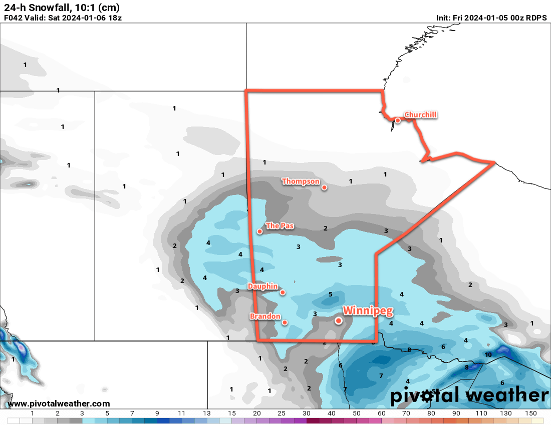
A passing disturbance will bring fresh snow to southern Manitoba today, then colder temperatures will begin to creep into the region.
A disturbance passing through southern Manitoba will bring 2 to 5 cm of snow to start the weekend.
The slow march of much colder Arctic air has brought it southwards this week. Temperatures have fallen into the -30s in the northernmost Manitoba, but this weekend’s passing disturbances will stall the southerly push. Instead, the cold air will fortify over the southern Arctic while a push of milder air across the southern Prairies brings fresh snow.
For today, a cold front will slump into southern Manitoba and then stall as a different system passes to the south through North Dakota. As it moves into the region, an area of snow will spread through WestMan towards the Red River Valley. A few flurries are possible this afternoon in Winnipeg, but the organized snow won’t likely arrive until the evening. Daytime highs will sit in the -10 to -5 °C range through much of southern Manitoba.
Snow will move through the Red River Valley tonight with 2 to 5 cm accumulation by Saturday morning. The cloud cover and stalling of the cold front will help keep it comparatively mild with lows near -10 °C.
On Saturday, the snow will taper off in the morning as the disturbance moves off to the east. Cloud cover will linger through the day as the cold front begins to push southwards again. Temperatures will hover around the -10 °C mark with northwest winds in the 20 to 30 km/h range.
The region will see cloudy to partly cloudy skies on Saturday night as a weak ridge moves across. Lows will dip into the -20 to -15 °C range as the winds ease.
Another disturbance will begin working towards the region on Sunday, spreading more cloud back into the region. The Winnipeg area will see a chance of flurries develop through the day as organized snow pushes into western Manitoba. It will be a cool day with highs in the -15 to -10 °C range.
This system will likely give 2 cm or less of new snow to the region as it spreads eastwards overnight. Temperatures will dip down into the -20 to -15 °C range on Sunday night with cloudy skies as the snow tapers off.
Long Range Outlook
A major pattern change is coming up next week: a major outbreak of Arctic air over the Prairies. It will begin to drop southwards into Alberta early in the week and help spin up a potent low pressure system that will track eastwards across the Prairies mid-week. It could bring a widespread 5 to 10 cm to much of the Prairies, followed by moderate to strong northwest winds and plummeting temperatures.
An outbreak of bitterly cold Arctic air will spread into the Prairies by the end of next week.
The latter half of next week will be marked by the settling of Arctic air across the eastern Prairies. Daytime highs in the -20s will be possible with a chance that overnight lows could dip below -30 °C. It will be an abrupt transition to dangerous cold in a winter that hasn’t seen it yet.
Be sure to get ready for it; get out the long johns, neck warmers and/or face coverings, get an emergency kit ready for your car, and consider seeing if you can help out any local shelters that may need resources to help with the upcoming cold.
Today’s seasonal daytime high in Winnipeg is -13 °C while the seasonal overnight low is -23 °C.
A building upper ridge over the Prairies through the next week will keep temperatures seasonably mild and dry throughout southern Manitoba.
Saturday will bring the warmest weather of the next 7 days with daytime highs climbing above freezing in many parts of southern Manitoba.
We’re off to a foggy start in Winnipeg today as warmer air pushes into the region aloft. The arrival of this warmer air will send temperatures climbing over the next couple days.
The fog will gradually lift through the morning, then the city should see a high just below freezing this afternoon. The mainly cloudy start should give way to mixed skies a bit later in the day. Temperatures will stay fairly steady tonight
On Saturday, low pressure system tracking eastwards through the southern Arctic will draw even warmer air into the region. Winnipeg should see a high near +2 °C on Saturday with mixed skies and light southerlies.
On Sunday, a cold will pass through the region, ushering in moderate northwest winds and cooler weather. A few flurries are possible in the morning as the cold front swings through, then temperatures will hover just below freezing for most of the day. There won’t likely be a lot of snow; Winnipeg could see a fresh centimetre or two with 2 to 5 cm possible to the southeast closer to the Ontario border.
Skies will clear out on Christmas Eve as winds ease and temperatures head to a low in the -10 to -15 °C range.
Long Range Outlook
A sharp upper ridge will build into the region next week and bring seasonably mild conditions, though not quite as mild as we’ll see on the weekend.
Beginning on Christmas Day and lasting through much of the week, Winnipeg will see mainly sunny skies and daytime highs around the -5 °C mark. Overnight lows will generally fall into the -10 to -15 °C range.
Today’s seasonal daytime high in Winnipeg is -11 °C while the seasonal overnight low is -22 °C.