IR Satellite Image of Late-March Storm over the Southern Prairies

Winter Storm Slams Manitoba

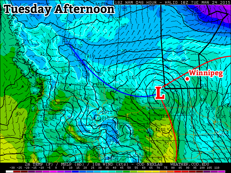
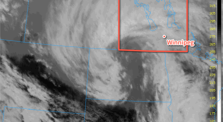
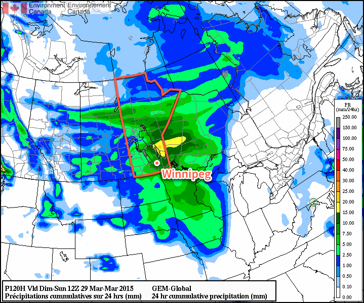
A potent spring storm is moving into Manitoba today and will likely exit the region known as one of the strongest of the Winter 2014/15 season. This storm has already brought drizzle, rain and freezing rain to southwestern Manitoba & the Red River Valley and will end up delivering the whole wintery mix by the time all is said and done. Environment Canada has issued a swath of heavy snowfall warnings and special weather statements across Manitoba in advance of this system.

Tuesday Night

Tuesday Night
-1°C
Rain changing to snow

Rain will redevelop this evening and persist through much of the overnight period until a cold front pushes through the Red River Valley and switches the precipitation over to snow. Many areas in the Red River Valley will see around 5-10mm of rain. Alongside the switchover to snow, strong northwesterly winds to 40-50km/h with gusts as high as 70km/h will begin to move into the Red River Valley. The combination of falling snow and strong winds, coupled with the temperature dropping below zero overnight after a day of melting, drizzle & rain will likely produce very poor driving conditions with slippery roads & poor visibilities in blowing snow by Wednesday morning.

Wednesday

Wednesday
⇒ -2°C / -11°C
Snow ending in the afternoon; windy

Snow will continue through Wednesday morning before beginning to taper off through the afternoon with a further 5-10cm possible for the City of Winnipeg and the Red River Valley. As mentioned before, the snow will be accompanied by strong northwesterly winds to 40-50km/h which will produce a fair amount of blowing snow as well. Temperatures will drop just barely to -2 or -3°C through the day. Given the relatively mild temperatures, it’s quite likely that as soon as the snow begins to taper off, the blowing snow will too; falling snow will be needed to produce it and it’s unlikely we’ll see much ground-based blowing snow after the fact. Winds will begin to taper off late in the afternoon or in the early evening as the storm moves off into Ontario. Left behind the storm will be partly cloudy skies as temperatures drop to around -11°C.


Storm Update

As expected, many regions across Manitoba saw a significant dump of snow overnight and into this morning. Snowfall totals to 10:30AM CDT across Manitoba are:

Location Snowfall Amount
Winnipeg 5cm
Portage la Prairie 5-10cm
Brandon 6cm
Steinbach 5cm
Dauphin 15-25cm
Rossburn 20cm
McCreary 18cm
Neepawa 15cm
Fisher Branch 15cm
Roblin 14cm
Elkhorn 10cm
Argyle 10cm
Swan River 8cm
Miami 6cm
Morris 2cm

In addition to the heavy snow, many areas through the Red River Valley saw several hours of rain last night. Here in Winnipeg, around 8mm fell overnight, and preliminary reports indicate that similar amounts were seen through much of the Red River Valley. In addition to the snow and rain, very strong winds to 50-60km/h moved into Red River Valley this morning producing blowing snow and helping make sure roads are slick.

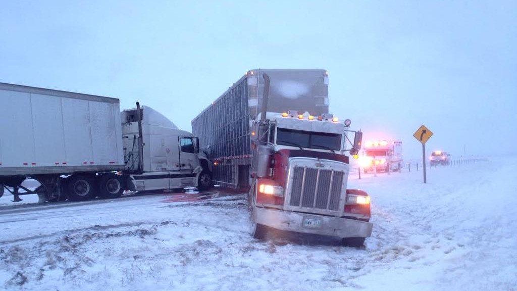
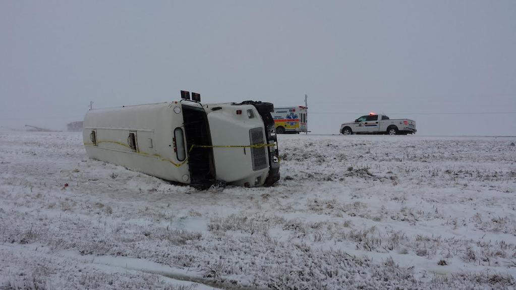
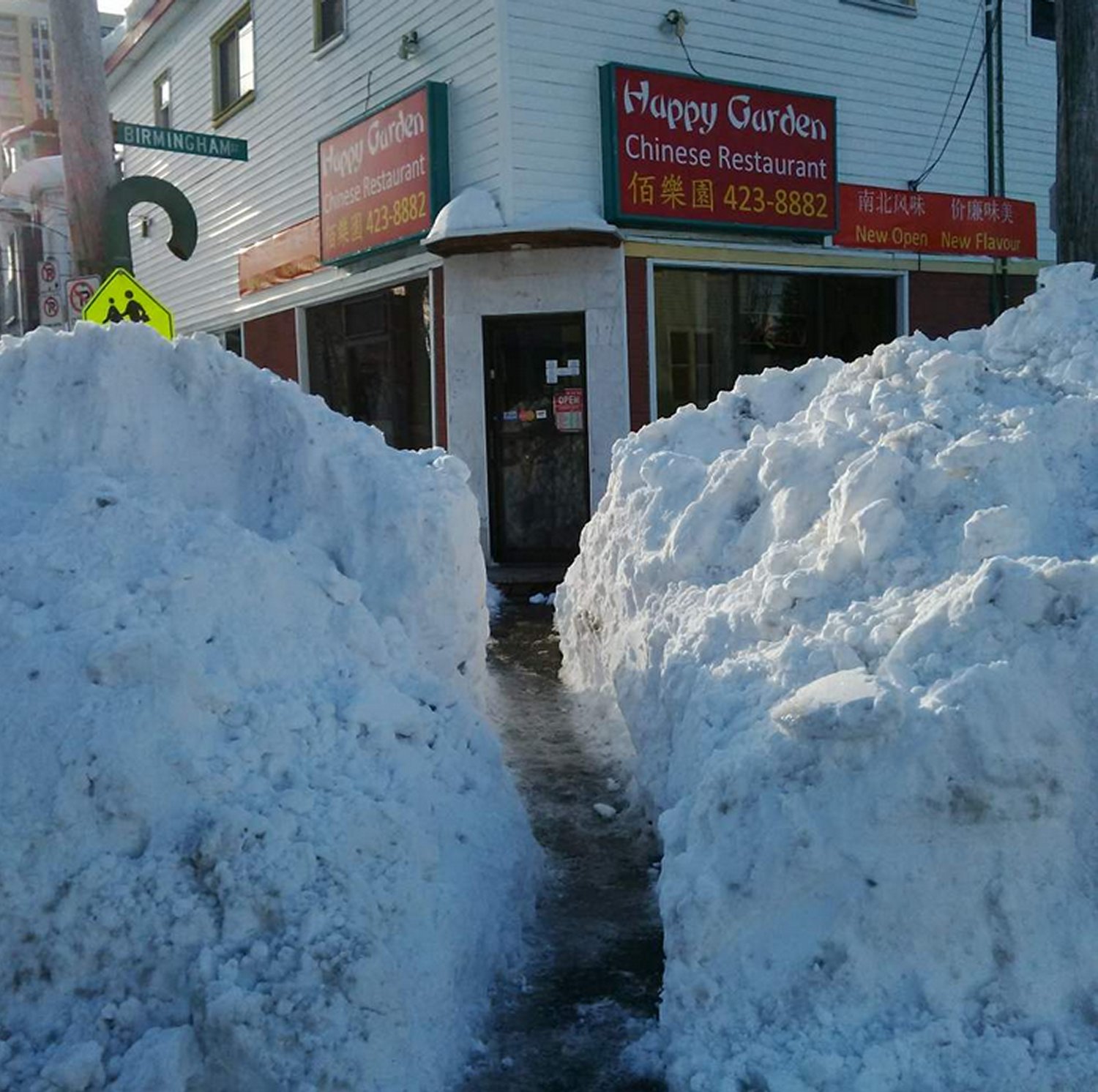
The winter weather has wreaked havoc on area infrastructure with numerous accidents on highways as well as complications to power infrastructure with numerous pole fires & power line damage events reported. Many motor-vehicle collisions were reported on Manitoba Highways, with several resulting in sections of Highways 1 and 75 being closed. Two of the more significant ones, pictured above, involved a jackknifed semi-truck collision near Elie and a school bus rollover near Ste. Agathe on Highway 75.

Conditions have begun to improve in the Red River Valley; winds remain strong however with the snow finally moving off into Ontario, much of the blowing snow has stopped. Road conditions will continue to be poor through the remainder of the day, so if you are driving, especially on area highways, be sure to give yourself extra time and be cautious.


Thursday

Thursday
-6°C / -11°C
Partly cloudy

Thursday will be a mainly sunny day – perhaps just a few lingering clouds – with a cool high of just -6°C. Winds will be light, so with the increasingly strong March sun it may not actually feel all that bad outside. Even with the sub-zero temperatures, expect plenty of melting to happen. We head into Thursday night with clear skies and cool off to around -10 or -11°C again overnight, although that could be a couple degrees warmer depending on when cloud cover arrives from…

Friday

Friday
-3°C / -8°C
Mainly cloudy with a chance of light snow

Friday will bring mainly cloudy skies as clouds push in either early Friday morning or late overnight on Thursday thanks to a system rippling through Southern Manitoba from the northwest. It will most likely produce a band of snow through portions of the Parkland, Southwest and into the Western Red River Valley. Under this band, accumulations of 1-2cm look possible at this time. There’s a little uncertainty as to the exact track, given that it’s 3.5 days out at this point, so it may end up a little further west or east. With the current “most likely” track, Winnipeg sees a fairly decent chance at some flurries but little in the way of accumulations. Temperatures will climb to around -3°C with fairly light winds. Friday night looks pleasant with light winds again and a low near -8°C.

Long Range

It’s looking as if another storm is possible on Saturday night as a shortwave tracks across Manitoba.

GDPS 24hr. QPF Forecast valid 12Z Sunday March 29, 2015
The GDPS is forecasting a fair amount of precipitation associated with a significant storm moving through Manitoba this weekend.

Fortunately, it seems like it will be bringing enough warm air with it that precipitation would fall as rain. Either way, though, it looks like we’ll see plenty of cloud and wind this weekend. After a long spell of little in the way of weather, it looks like a typical, more active springtime pattern is setting up!

Say it Ain’t Snow

Snow will make a late-season appearance this week, an unwelcome surprise in what has generally been a very pleasant March.

Significant snowfall will be possible by the middle of this week as a low pressure system moves into the region

Monday

Monday
3°C / 0°C
Flurries ending

Today will see some light snow tapering off in the morning as a system from overnight exits the region. Thankfully, temperatures will rise above zero by this afternoon, which should melt most of the snow that fell last night and this morning. Once the snow ends skies are expected to remain mainly cloudy and but winds will remain light.

Tuesday

Tuesday
6°C / 1°C
Mainly cloudy with chance of showers

Tuesday looks to be warmest day this week as we sit in the warm sector of the winter storm that will bring us snow on Wednesday. Temperatures will be in the mid to upper single digits, which should help to eliminate any of Monday’s snow that was yet to melt. There may be a few stray showers throughout the day, but otherwise no significant precipitation is expected. The main event will arrive overnight…

Wednesday

Wednesday
2°C / -12°C
Snow

The much-discussed winter storm will arrive on Wednesday. It will not be a particularly powerful storm by any measure, but that won’t stop it from producing significant snowfall in some areas. Currently, it appears that Winnipeg and the Red River Valley is in line for 5-10 cm from this system. Areas further west, particularly in higher elevations and upslope terrain, could see closer to 30 cm. However, it is still too early to place a large amount of confidence in these predictions. As we get closer to Wednesday, more accurate snowfall forecasts will become available.

Long Range

Following the departure of Wednesday’s storm we’ll see temperatures drop back down to below seasonal values to end the week. Models suggest that we’ll continue to be caught between a trough to the east and a ridge to the west, meaning we’ll see frequent oscillations between slightly above and slightly below normal conditions. Until this pattern shifts our weather will continue to be a bit of a roller-coaster.

Elsewhere in Weather News: March 21st, 2015

Maritimes Experience a Winter to Remember

With spring now in place Maritime residents would expect to see more forgiving weather than they have been experiencing this past winter. However, this has not been the case this past week. The East Coast has been hit with another strong coastal storm that brought blizzard conditions and large amounts of snow Tuesday-Wednesday. A fairly deep low pressure system was anchored just off the coast and drew in some cold air in behind – conditions right for a blizzard.

[map autofit=”1″ disable_scrollwheel=”1″] [pin]Halifax, NS[/pin] [pin]Saint John, NB[/pin] [/map]

Halifax was especially hit hard by this storm with a general 35cm falling in the city, with some higher amounts reported. These combined with winds that gusted up to 113km/h to create blizzard conditions. Schools, businesses and government offices were forced to shut down and no public transit was running. Currently, Halifax has a whopping 93cm of snow on the ground which almost doubles the old record of snow on ground of 51cm in 1967 for today (records for snow on ground have been kept since 1955 in Halifax). Saint John, NB even had more snow than that on the ground after the storm – 169cm of snow was on the ground Thursday.

Sidewalks in Halifax are getting quite narrow after the most recent snowstorm. (Source: Twitter/@HadynWatters)

Unfortunately, yet another system is set to affect the Atlantic Provinces as another strong trough makes its way towards the East Coast. The storm will really ramp up later this afternoon – numerous types of precipitation will be in play, with mostly rain near the shoreline, transitioning to mixed types and finally heavy snow as you head further inland. The highest snowfall amounts are expected to be around 40-50cm where it will be all snow, and as much as 20mm of rain could fall in Halifax. City crews have begun clearing city drains to limit the flooding that could take place if most precipitation falls as rain in Halifax.

In other news, Australia has been hit with another strong cyclone this week. The cyclone had a fairly small inner core, but still managed to bring winds of up to 170km/h near Cooktown and a decent storm surge to the coast. Thankfully no injuries were reported with the storm and it is currently in the dissipating stage over northern Australia.

Elsewhere in Weather News: March 7th, 2015

Winter Storm Races across Southern, Midwest US

This past week a strong late season winter storm made its way across the southern and east-central parts of the United States bringing with it all kinds of precipitation: rain, snow, ice pellets and freezing rain. An Arctic front pushing south across the region was the culprit for the mixed precipitation types. Warm air was able to ride over the cooler air racing south near the surface which made for a melting layer above ground and able to melt/partly melt the precipitation. Before it reached the ground the precipitation encountered below freezing temperatures once again which resulted in the freezing rain, or ice pellets if the melting layer was not as deep.

Sounding from Little Rock, AR show a melting layer with below-freezing temperatures closer to the surface.  Black line is the 0°C isotherm.
Sounding from Little Rock, AR show a melting layer with below-freezing temperatures closer to the surface. Black line is the 0°C isotherm.

Large traffic jams on the freeways due to accidents, school closures and power outages were the result of the storm and 13 deaths across several states were directly related to the storm. Impressive and unusual snow amounts for this time of the year were recorded anywhere from Dallas, Texas to Lexington, Kentucky. Here are a few impressive amounts recorded from the storm, provided by the National Weather Service:

  • Lexington, KY: two-day total of 43.4cm (all-time two day record)
  • Tupelo, MS: one-day total of 18.5cm (second snowiest day on record)
  • Dallas, TX: storm total of 8.9cm
[map type=”terrain” autofit=”1″ disable_scrollwheel=”1″] [pin]Lexington[/pin] [pin]Tupelo[/pin] [pin]Dallas[/pin] [/map]

No more snow is expected in the near future, but record-breaking cold temperatures followed last night. Warmer and closer to normal temperatures are on the way for next week as a pattern change takes place and colder air remains locked up further north.