Conditions will change dramatically this weekend with no thanks to an Alberta clipper system that will spread snow into Southern Manitoba tonight and usher in extremely cold Arctic air1 to the region on it’s back side. Before that system arrives tonight, however, we’ll get to enjoy a beautiful day with temperatures climbing towards the 0°C mark!
-2°C / -18°C
Mostly cloudy and warm. Chance of an afternoon flurry. Snow beginning overnight.
⇒ -18°C / -32°C
Snow. Windy with blowing snow. Cold.
-26°C / -33°C
Mainly sunny. Very cold.
Today will be an exceedingly pleasant day for what has been a markedly cold December. Thanks to a flow of mild Pacific air brought in by westerly winds ahead of the Alberta clipper, we’ll see our temperature climb to around –3 or –2°C today with relatively light winds. Skies will likely remain mostly cloudy through much of the day with the cloud cover being bolstered by the warm temperatures over the snow and a weaker leading impulse tracking through the Interlake. We may see a few breaks in the cloud here or there, particularly through the mid-to-late afternoon period. Unfortunately, that’s where the good news ends. An Alberta clipper is on the way, and it’s a doozy.

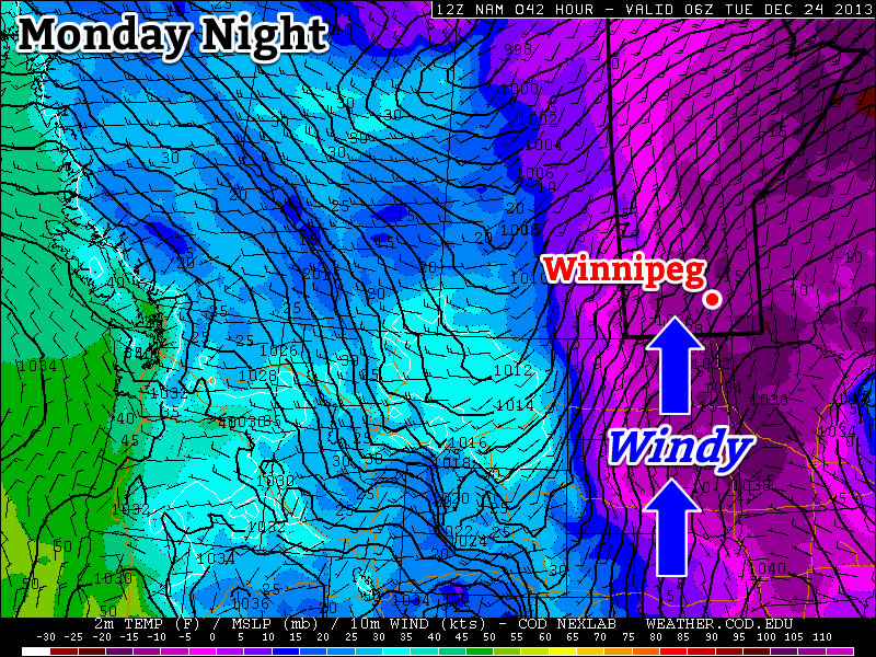
The system will begin spreading snow into the Red River Valley overnight along a line cutting across the northern Red River Valley. The heaviest band of snow will set up along the main frontal zone aloft which will be aligned roughly from Dauphin to Winnipeg and ESE into the Whiteshell. Underneath the heaviest band of snow around 5-10cm of snow can be expected by Saturday morning with amounts tapering to just 2-3cm near the US border. In addition to the snow, a cold front will begin to slump southwards late overnight which will usher in much cooler air. We’ll see temperatures drop to around –18°C with winds shifting out of the north.
Saturday
Saturday will be…miserable. Our temperature will remain steady near around –18°C as cold air continues to infiltrate into Southern Manitoba. Snow will persist through much of the day — although it will likely lighten to just a few flurries by the late afternoon — with another 2–5cm expected to fall across the Red River Valley which will bring storm-total snowfall amounts to around 5cm in areas on the fringes of the system track and anywhere from around 7–15cm under the heaviest band of snow. The winds will become more of an issue on Saturday as they increase out of north to 30–40km/h with gusts as high as 60km/h. These winds, aided by the fresh snowfall, will create areas of poor visibility in blowing snow, especially on any west-east running highways.
Please note: Driving conditions will likely be extremely poor on Saturday morning. In addition to the blowing snow, roads will likely be extremely slippery; the warm temperatures on Friday will likely produce moisture on road surfaces which will rapidly freeze overnight. On Saturday morning, roads will likely be icy with fresh snow on top and blowing snow on top of that. If you need to travel, carry a winter survival kit and give yourself lots of time to reach your destination.
The system will move out on Saturday night bringing clearing skies and extremely cold temperatures as an Arctic airmass settles over the region. Our overnight low will bottom out at about –32°C with fairly light winds.
Sunday
Sunday will be a mainly sunny but very cold day. The temperature will only recover to the low minus 20’s. Winds will remain light — little consolation given the temperatures, though. It’ll drop to around –33°C on Sunday night under clear skies.
When Will It End?

Unfortunately, all signs point to the cold weather sticking around for at least the next 4–7 days, if not longer. The NAEFS guidance shows below-normal temperatures expected in the 8–14 day range while all the shorter-range models show cold weather through the next week. The GFS is hinting at a system that might push through late next week that would bring slightly milder temperatures, but it would be short-lived and doesn’t look indicative of a pattern change.
It looks like we’ll definitely be closing out December 2013 as one of the Top 5 coldest Decembers on record in Winnipeg with little reprieve on the horizon. So go enjoy the last nice day of 2013 and then get your long johns ready, plug in the car, get a warm drink, fill up the hot water bottle, renew your CAA membership and whatever else you need to do to prepare for another prolonged bout of extreme cold.
- I’m doing my best to not use the phrase “bitterly cold” in today’s blog. ↩