This week will start out with fairly typical conditions for this time of year. No significant weather is expected.
Monday
Flurries
-4°C / -7°C
Monday will be a cloudy day, with a good chance of flurries. These flurries will be fairly disorganized in nature, but could amount to a couple of centimetres in many areas. Models do suggest that some localized areas could see close to 5cm by the time this area of snow completely dissipates on Tuesday morning. However, confidence is very low in terms of predicting which areas might be in for these slightly heavier amounts. As such, I’ll just suggest that any location in Southern Manitoba does stand a small chance of seeing close to 5cm if heavier periods of snow get stuck over the area. Temperatures on Monday will be in the low to mid minus single digits in most of Southern Manitoba. Parts of western Manitoba may get up around the freezing mark as the wind there will switch to westerly, giving a downslope flow.
Tuesday and Wedensday
Mix of Sun and Cloud. Chance of Flurries.
-8°C / -15°C
Mainly Sunny
-4°C / -7°C
Tuesday is a bit of a tricky forecast, albeit in a non-threatening kind of way. It looks like we may get stuck in low-level cloud and possible light flurries through the day. Alternatively, skies may clear and it could be a fairly bright and non-snowy kind of day. In either case, high temperatures will be in the mid or upper minus single digits with a breezy north-westerly wind.
Wednesday should see sunny skies return. Unfortunately, temperatures will remain stuck just below zero, as a stiff southerly flow prevents strong mixing and maximum temperature rises. As a result, we’ll see high temperatures once again in the low to mid minus single digits.
Long Range
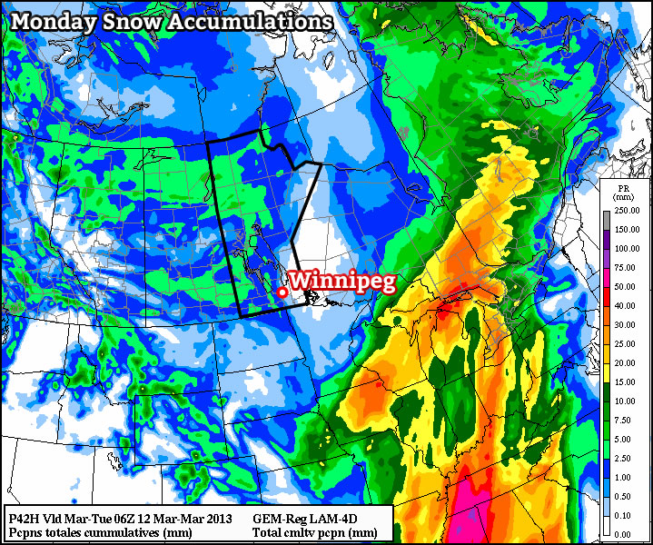
The long-range still doesn’t look very spring-like unfortunately. Even worse than that, models continue to hint at a stormy pattern returning to southern Manitoba towards mid-March. If you’re hoping for spring, you’d better cross your fingers that a renewed storm track through our area brings rain, rather than more snow!