Elsewhere in Weather News: November 8th, 2014

Super Typhoon Nuri Transitions into Strong Extratropical Storm

The Western Pacific continued to be active this past week, spinning up yet another violent storm, which thankfully remained at sea and did not impact land. Nuri formed late last week west of Guam and slowly drifted west-northwest. It organized itself as conditions became ideal for strengthening of the typhoon: sea surface temperatures were very warm and wind shear was low. Nuri became a super typhoon last weekend as it deepened to a central pressure of 910mb and brought estimated sustained winds of 285km/h – similar conditions to what super typhoon Vongfong had at its peak this past October. Up to date, these two are tied for the strongest tropical storm of 2014. Nuri quickly curved Poleward before reaching Japan, sparing the Japanese islands from the storm.
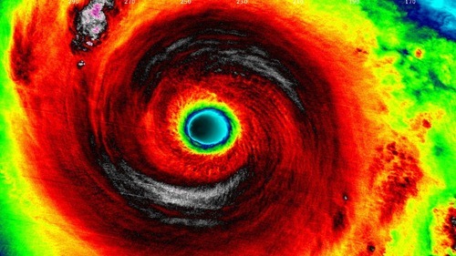
IR satellite image of Nuri as it held super typhoon strength this past Sunday/Monday. (Source: Soumi NPP VIIRS)

Nuri did not end there, however. As it got captured by the polar jet stream, it transitioned into an extratropical storm. Extratropical storms are the low pressure systems that we see across the mid-latitudes, including here in Manitoba. They have significant differences from their tropical brethren, the most significant being that extratropical storms have warm and cold fronts that generate energy for the storm, as opposed to tropical systems that have generally uniform temperature. As the remnants of Nuri transitioned into the Polar Jet they strengthened once again, aided by a strong temperature gradient aloft.[1] Projected wave heights on the Bering Sea neared 50 feet as the storm “bombed” out[2] on Friday to a minimum pressure of 927mb. Extremely strong winds were recorded on the Aleutian Islands, where gusts exceeded 150km/h.
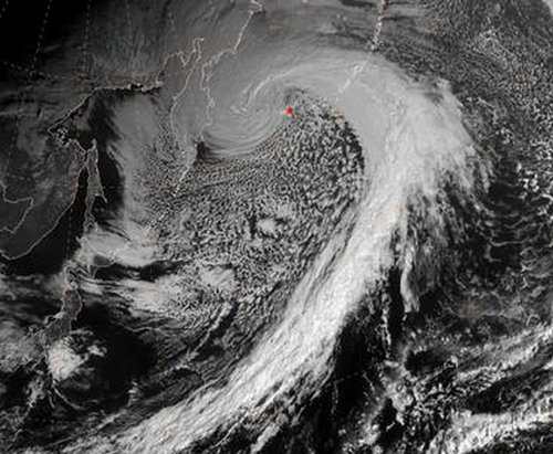
Satellite picture of the remnants of Nuri as an extratropical storm on Friday.

The remnants of Nuri are expected to continue moving towards Alaska but weaken significantly by the time they reach the Alaskan shores, as the low pressure system enters its weakening phase.

Alaskan Bomb Results in Arctic Outbreak over Central & Eastern North America

The intense storm over the Aleutian Islands is also indirectly responsible for the outbreak of cold air expected in the coming week over much of North America. As the system intensifies over the Aleutian islands, a strong upper-level ridge will build over the west coast of North America which will cause a resultant upper level trough to deepen over the remainder of the continent.
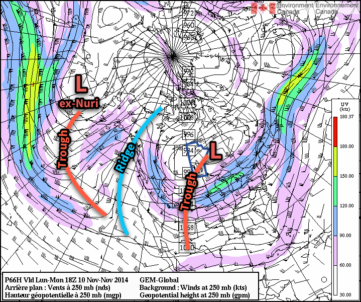
The GDPS shows prominent ridging over the west coast of North America, resulting in a deep upper-level trough over central & eastern North America.

The deep upper-level trough will allow the cold air that’s been bottled up in the Arctic to spill southwards, resulting in well below seasonal temperatures across a significant portion of Eastern North America. The developing upper-level pattern is a fairly stable configuration for the flow, so no significant changes will likely occur in the next week or two other than gradual moderation.
  1. The strong temperature gradient was easily evident by a very strong jet streak of over 130 knots – that’s over 240km/h – at 500mb!  ↩
  2. A system has “bombed” when its central pressure drops 24mb or more in 24 hours.  ↩

Elsewhere in Weather News: July 26th, 2014

Saskatchewan Chase July 24th

An unusually strong upper level low for this time of the year nosed into the southern Prairies and was the focus for severe storms last Thursday. All the ingredients were present for severe storms that day, as Brad alluded to in his discussion of the event posted on the day of. Keeping in mind that this might be one of the last chases this season, due to the jet stream slacking up, a few of us made our way into Saskatchewan to chase the storms.

The day was off to somewhat of a surprising start as we woke up early to find a large squall line was sweeping across southeast Saskatchewan, southwest Manitoba and North Dakota. Thankfully, as the squall line moved away from the main instability axis in the morning it started weakening and its leftover cloud wouldn’t hamper our chances in Saskatchewan for the surface based storm development in the afternoon. After determining that skies would clear in the south-central part of Saskatchewan by late morning, the chase was on. From Winnipeg we drove straight to Brandon, grabbed a quick bite to eat and from there made our way to Weyburn, SK. After arriving in the mid-afternoon, we took a quick look at the satellite only to see some bubbling cumulus and even towering cumulus well to our southwest. By then it was obvious that nothing would fire in the Weyburn area with a stout cap present and no trigger around.

We then had to make a decision to either call it a day or head to south-central SK – where there was plenty of upper forcing and a cold front in the region (further west than what the models were showing). Since we were already that far into SK, we went all in and drove a good 100km west to the Assiniboia region. By the time we got there a couple supercells had already fired; we picked the one that looked best (just south of Assiniboia) and stuck to it.

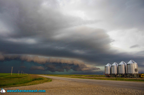
Picture of the storm as it matured, looking towards a section that was bowing out, with a good shelf cloud. (Source: Matt)
Picture of the storm as it matured, looking towards a section that was bowing out, with a well-defined shelf cloud. (Source: Matt)

Following it for over two hours, we were able to spot two funnel clouds. One may have touched the ground, but we were too far away to tell (hence lack of pictures) while the other a brief funnel that spun up later in the evening on the leading edge of a bow echo. We followed the storm which evolved into a line with multiple bow echos embedded along it. Later in the evening the line became elevated, eliminating the wind threat but still able to produce a lot of cloud to ground lightning. The complex eventually died off in southwest Manitoba and left a large area of stratiform rain in the area.

Overall it turned out to be a fun chase day, with a storm that teased us with a few funnel clouds, combined with good structure and a nice light show. What we didn’t see from that day were the large hailstones that were later reported as well as strong wind gusts of 119km/h reported in Assiniboia.

Mild Start to the Week, Stormy to the South

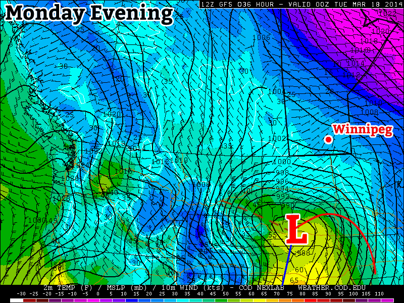
This week will start out with mild weather in southern Manitoba while a major storm system passes just to our south.

A major weather system will pass just to our south on Monday

Monday

Monday
-1°C / -4°C
Increasing Cloudiness. Chance of Flurries.

Today will feature nice weather in southern Manitoba. Temperatures will be near the zero degree mark with light winds. However, just to our south a major storm will be taking shape. This storm is expected to bring heavy snow to the Dakotas and Minnesota. There is still uncertainty about where the heaviest snow will fall, but if you have travel plans into the northern United States early this week you’ll definitely want to check the weather forecast along your route.

Tuesday

Tuesday
-1°C / -10C
Mainly Cloudy

Tuesday will be another mild day in southern Manitoba. Temperatures will once again be near the freezing mark with a light northerly flow. As you might expect, this north wind will be generated by that big storm to the south.

Wednesday

Wednesday
-1°C / -12°C
Mainly Sunny

Wednesday will be another mild day, with temperatures generally just below freezing. We should finally be clear of the storm system from earlier in the week, with clear skies being the order of the day. The wind will be from the north-west, but it won’t be particularly strong.

Long Range

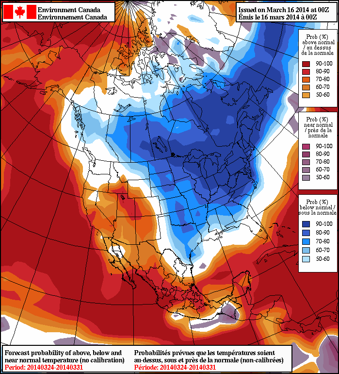
The long range forecast calls for below normal temperatures in southern Manitoba for the end of March

Unfortunately, the long range forecast suggests a return to more wintry conditions for awhile. Most long-range guidance shows cool to cold conditions for the end of March. It remains unclear how the month of April will unfold.

Miserable Weather on Tap

Don’t let the bits of sun and relatively warm temperatures fool you; tonight is going to be downright awful.

A complex double-barreled low pressure system (a term used when two separate lows are moving together as one entity) is moving out of Saskatchewan and Montana into Southern Manitoba this morning.  This system has brought a mix of precipitation into Southern Manitoba this morning, including freezing rain over western areas and heavy snow in the Interlake.  Numerous warnings have been issued across the region for weather happening now or expected to happen this evening.

The risk of freezing rain will persist through much of Southern Manitoba for an hour or two longer before temperatures will be warm enough that any precipitation will simply fall as rain.  Even though little precipitation has fallen over the Red River Valley this morning, Manitoba Highways is reporting that many sections of Highway 75 and Highway 1 heading west of Winnipeg are partly iced cover due to the slight melt and re-freeze yesterday afternoon.  As temperatures will just barely get over 0°C today, there may be portions of highways that are still quite slippery throughout the day.

Tonight
Perhaps the biggest impact from this storm will occur tonight over the Red River Valley.  As the low passes to the east, cold air will plummet down the backside of the system through the RRV.

 
24hr Accumulated QPF valid 12Z Saturday March 12, from the 00Z run of the GEM-LAM REG Model 

As the system passes, an intense band of wrap-around precipitation will move into the RRV, bringing heavy snow to Winnipeg by 6 or 7PM tonight.  Along with this heavy snow, this system will bring significant winds as well.


Surface Winds valid 06Z Saturday March 12, from the 06Z run of the GEM-LAM REG Model 

Sustained winds of 50-60 km/h with gusts potentially as high as 90 km/h will blast cold air into the RRV, which will plummet the temperature from 0°C or +1°C down to approximately -14°C or -15°C over the span of a few hours.  This will rapidly freeze any standing water which will very likely create extremely slick roads tonight.  And last but not least, these winds, combined with the heavy snow, will very likely produce blizzard conditions through a good portion of the night.

The weather conditions will deteriorate extremely quickly this evening to become a significant winter storm.  Anyone who has plans to travel in the Red River Valley tonight should keep updated on warnings, forecasts (or for a smartphone), the RADAR, and highway conditions to be able to make safe, educated travel plans.  Good satellite imagery to track this system can be found here at the U of M.