Typhoon Soudelor Takes Aim at Taiwan and China

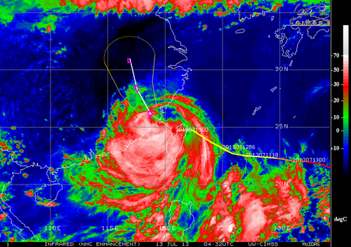
A tropical disturbance that was once a powerful super typhoon over the open waters of the Western Pacific earlier this week has now slightly weakened and is taking aim at southeastern Asia.

As of Friday night Soudelor was a typhoon of strength equivalent to a category two hurricane and had just made landfall on Taiwan’s northeast shores. The typhoon packed sustained winds of about 170km/h gusting to over 200km/h Friday night as it made a direct landfall on the island of Taiwan. The biggest threat with the typhoon, however, was rainfall. Taiwan’s rugged terrain meant that orographic lift (lifting of air pushed up the mountains) would greatly enhance precipitation amounts, especially on the north side of the island. Models showed that as much as a metre of rainfall (or more) could fall before it is all said and done.

Visible satellite image of Soudelor at sunrise late Friday evening (our time). (Source: Himawari Sat.)

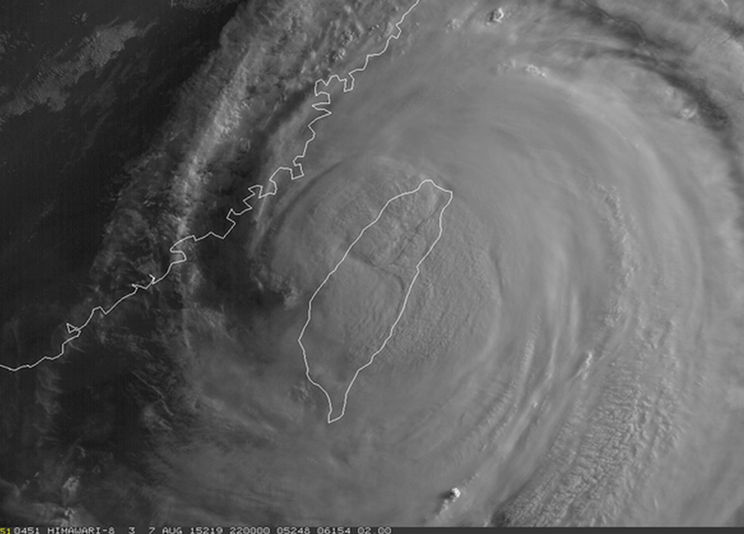
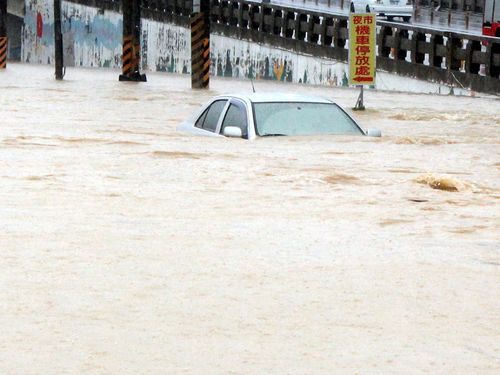
The effects of typhoon Soudelor are still uncertain as of Friday evening but the Taiwanese authorities reported that there were over 2.6 million residents without power, wreaking havoc on day to day activities as well as travel in the region. In addition to that, as of Friday night there were four confirmed deaths associated with the typhoon, two of which were associated with the storm surge which had the biggest impact on the northeast shoreline. The station that clocked the highest rainfall amounts as of Friday evening was the town of Taipingshan, which was already well over a metre of rainfall (1,241mm). Taipei, which is less than 50km from this town, had already recorded an astonishing 500mm in some parts of the city.

Conditions are expected to continue to be poor until later today, as the heavy rains are expected to continue to fall in the northern half of the country. Soils will become saturated, if not already, and overwhelmed by the rainfall, resulting in mudslides in the mountainous regions – a region of Taiwan which is known to be very prone to these types of disasters. Soudelor’s effect on China isn’t expected to be as severe, but heavy rain/flooding will once again be the main threat as the tropical system moves over China’s mainland and begins to weaken.

Elsewhere in Weather News: August 31st, 2013

Flooding Problems for Taiwan

This past week the southern half of Taiwan has been experiencing significant flooding following a tropical storm that made landfall. Tropical storm Kong-Rey made landfall on the 29th bringing with it drenching rains. Very high rainfall accumulations along the west coast of Taiwan were reported, 500 millimeters in some areas within a span of 48 hours. That’s about as much rainfall as Winnipeg gets in a year! The flooding rains made so that second-story levels of building were underwater in some areas. Around 3,600 people had to be evacuated of the low lying areas while three perished in the floods.

Kong-Rey flooding

Flooding in Minsyong, Taiwan. (Source: Focus Taiwan News)

Kong-Rey has since moved off to the north-east and skirted around Japan’s west coast. No severe weather was experienced in Japan since it has been downgraded to a tropical depression and had significantly weakened. As of Saturday morning not much was left of the tropical depression as it has continued drifting into the Pacific and will die off there.

Elsewhere throughout the globe not much significant weather has been occurring this week. The Atlantic hurricane season has been remarkably slow this year with no hurricanes and only six tropical storms. No hurricane development is expected in the next few days, though September is on average the most active month of the year in the Atlantic.

Also, a quick update on the large California wildfire burning near Yosemite; the fire is now about a third contained as the crews continue to battle the fire. The weather pattern is expected to remain relatively the same as last week over the area – warm and dry for the coming week.

Elsewhere in Weather News: July 13th, 2013

Strong Typhoon Makes Landfall in Taiwan

A strong typhoon, Typhoon Soulik, has made landfall in northern Taiwan last night bringing heavy rainfall and strong winds in the order of around 160km/h – considered category two. Soulik, once a category four typhoon, encountered cooler waters before making landfall and Taiwan’s rugged terrain continues to tear it apart. It’s expected to cross the South China Sea and make a second landfall on China’s southeast coast as a tropical storm. Most models show it heading into China’s mainland weakening into a tropical depression and further on, a low pressure system. Although only a tropical depression, Soulik will bring copious amounts of rain into the mainland, prompting fears of possible flooding later this weekend.

Soulik

IR image of Soulik on Friday night. Expected track and intensity overlayed. (Source: CIMSS)

As of Friday night, electricity disruptions, 1 death and two dozen injuries had been reported. Around 8,500 people had been evacuated prior to Soulik making landfall because they lived in landslide-prone terrain.

Elsewhere in Weather News: August 25th, 2012

Isaac Threatens Southern States

This past week a tropical disturbance in the central Atlantic, east of the Caribbean, has strengthened into a tropical storm – Isaac. As of Friday night, Isaac had sustained winds of 112km/h, a central pressure of 990mb and was eyeing (no pun intended) Haiti. It is especially worrisome that Isaac, a strong tropical storm, is moving towards one of the most impoverished countries in the world, where nearly 400,000 people are still living in tents after the major earthquake back in 2010.

Isaac

Isaac on infrared satellite with centre of circulation identified by arrow. Purple, red represents very cold cloud tops. (Source: WSI)

Isaac will make landfall as a strong tropical storm as it crosses Haiti and then heads toward Cuba. It might have trouble sustaining its strength due to the mountainous terrain of the islands but as it emerges into the Gulf of Mexico, Isaac should organize itself quickly as it takes aim at the Gulf States such as Florida, Alabama, Mississippi and Louisiana. It is expected that Isaac will make landfall on American soil, somewhere on the western part of the Florida Panhandle on Tuesday afternoon. By that time Isaac will have intensified enough to be of hurricane strength, most likely category one. Residents of the Gulf States will have to monitor conditions closely to secure items outside and be ready to evacuate; storm surge along the coast and flooding because of the heavy rains is likely to occur. It will not be uncommon to see rainfall amounts of 100-200mm in the hardest hit areas in the Caribbean and US, however, the more rugged terrain of the islands on the Caribbean could have more devastating effects; landslides and flash flooding.

Isaac track

Isaac’s projected track. (Source: News 13)

In other news around the world, Taiwan has been hit with yet another storm – typhoon Tembin that had sustained winds of 155km/h but struck a less populated area of the country, leaving the large cities like Taipei with only minor flooding and wind damage.