Hot and muggy weather will stick around in Winnipeg for a few more days along with more chances for thunderstorms. Some relief is on the way for the end of the week, though, with more seasonal conditions arriving on Friday.
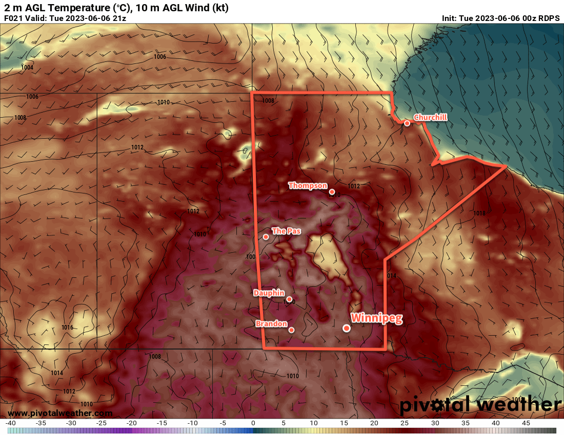
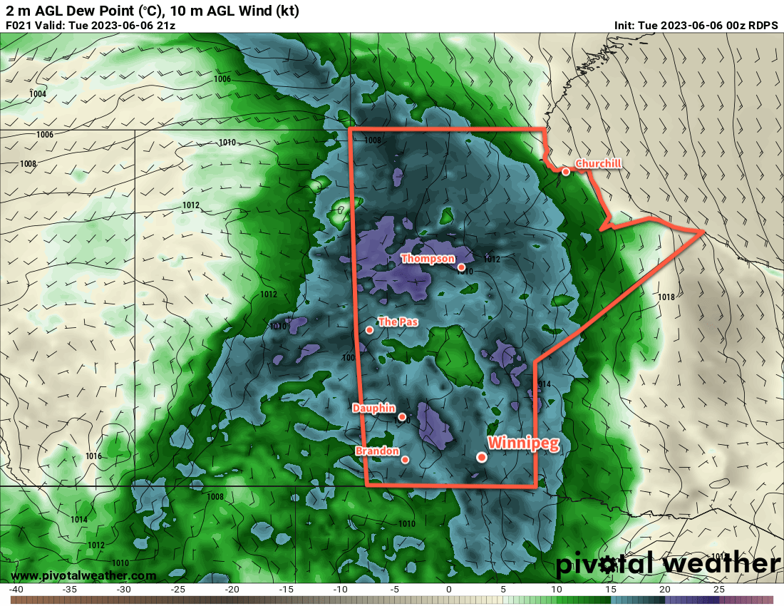
A hot and humid air mass will remain in place over southern Manitoba on Tuesday.
An upper high entrenched over the eastern Prairies means little change is on the way for Winnipeg over the next few days. That said, there is a change on the way. A developing low pressure system over the southern Arctic is beginning to push cooler air into the northern Prairies. As it matures in the coming days, that cooler air will continue to slump southwards through the Prairies. By Friday, this cold front will sweep through southern Manitoba, clearing out the humidity and lowering temperatures back towards more seasonal values.
Before we get to that, though, there will be a few more days of hot and unsettled conditions in the Winnipeg area. The daytime high will reach the low 30s again today, then ease into the upper 20s for the next couple days. That humid air mass will keep overnight lows mild with lows in the 18 to 20 °C range.
Each of the next few days will also continue to bring a risk of thunderstorms across the region. Here in the Red River Valley, scattered thunderstorms are possible today, but not likely until closer to the evening. Much of the activity will stay west of the region on Wednesday, but an isolated thunderstorm is possible. On Thursday, a chance of thunderstorms will develop across the region later in the day as a cold front pushes through.
With the heat and humidity in the region, there will be a risk of severe thunderstorms over the region. That being said, most will likely be non-severe. Any that manage to organize to severe limits will mainly pose a torrential rain and hail threat.
Long Range Outlook
A break from the heat and humidity will stick around for the weekend, a welcome relief for many. Daytime highs will vary from the low to mid-20s this weekend, feeling very comfortable thanks to lower humidity levels. That drier air mass will also allow overnight lows to cool off into the low to mid-teens.
Warmer weather is expected to return next week with daytime highs climbing back into the 30s.
Today’s seasonal daytime high in Winnipeg is 23 °C while the seasonal overnight low is 9 °C.
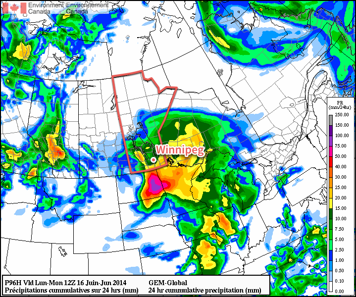
After a prolonged period of hot and humid weather across Southern Manitoba, a frontal wave pushing eastwards triggered numerous severe thunderstorms across southeastern Saskatchewan and southwestern Manitoba. None was worse than a thunderstorm that exploded over southwestern Manitoba and rapidly developed into a massive supercell thunderstorm. After a short while, this storm organized and produced its first tornado; this would end up being just one of numerous touchdowns over the course of the following 3 hours. The tornadoes this supercell thunderstorm produced were staggering in their intensity; perhaps most notably was the tornado it produced near Tilston, Manitoba whose size and power shocked even veteran storm chasers.
Pre-Storm Setup
Forecasters knew days ahead of time that Monday had the potential to be a significant day across southeastern Saskatchewan and southwestern Manitoba. A cold front that had pushed eastwards across the Prairies over the prior couple days stalled out over the Saskatchewan-Manitoba border on Sunday as a strong jet crashing in over the west coast dug into the upper-level trough, deepening and tilting it while the upper-level ridge built over eastern Manitoba in response. This allowed even more heat and moisture to build over the region at the end of a week that had already seen dew points regularly above 20°C with temperatures climbing into the upper 20’s or low 30’s. On Monday, a shortwave ejected out of the trough and lifted northeastwards, temporarily reversing the cold front and transforming the boundary into a nearly-stationary warm front. As the shortwave moved through the region, it triggered the thunderstorms and began to sweep the frontal wave off to the east-northeast.
On Sunday, it was already looking conditionally likely for tornadogenesis in any thunderstorms that developed over southwestern Manitoba. Pulled directly from the PASPC Significant Weather Discussion:
SIGNIFICANT WEATHER DISCUSSION ISSUED BY THE PRAIRIE AND ARCTIC STORM PREDICTION CENTRE OF ENVIRONMENT CANADA AT 2:00 PM CDT SUNDAY JULY 26 2015.
[…]
Eastern Prairies… The light southerlies are bringing even more heat and humidity. Most areas, especially the Red River Valley, look to be a degree or two warmer today and that will push humidex values into the low fourties today. A heat warning as thus been issued for the Red River Valley and Central Interlake. As of 18Z values are already between 36 and 38. The heat continues Monday but should be below 40 in most localities.
Meanwhile, the cold front from the low in Central Saskatchewan will lie along the Manitoba/Saskatchewan border by early afternoon today at which point its eastward progression begins to slow dramatically. This feature will be the focus of nearly all severe weather potential for the next 48 hours. Ahead of the front in Southern Manitoba, MLCAPE values increase to 2000 to 2500 J/kg this afternoon with 30-40 knots of deep layer shear. While the jet maxima remains well to the west, there are still 40 knot southwesterlies at 500mb and 40 knot southerlies at 850mb pushing in from the Dakotas. This could produce a few more supercells as it did Saturday over Alberta and Western Saskatchewan. However, continued warm air advection all the way up to 700mb makes most of the south capped for the day – particularly so in the extreme southeastern corner. Terrain and remnant outflow interactions closest to the front make the Westman and Interlake areas the most likely to see severe thunderstorms but overall the risk looks moderate this afternoon and early evening if the cap breaks.
A new low pressure system develops rapidly late Sunday in Eastern Montana bringing strong easterly winds in the low levels to the International Border areas in Southeast Saskatchewan and Southern Manitoba Monday afternoon. Hodographs have impressively veering profiles with up to 55 knots of deep layer shear accompanied by 2500 J/kg MLCAPE. This has potential to develop tornadic supercells, with forecast 0-3KM EHI values of 4+ and SIGTOR of up to 2 in the area with even higher values south of the border. However, this is all very conditional at the moment, as strong thunderstorm development today or tonight could shift boundaries somewhat or consume much of the instability over the area. Cloud cover in general could also be an issue for daytime heating, both from remnant overnight cells but also from the upper level jet closing in from the west. Finally, the same strong low level advections are building a very strong cap of -100 J/kg or stronger. Once again, regardless of daytime activity, this same setup is promising for severe elevated convection for Manitoba south of the Interlake and the Estevan area Monday night.
[…]
It was clear that there was going to be a heightened and dangerous severe weather potential on Monday. By Monday afternoon, things had become even more clear:
SIGNIFICANT WEATHER DISCUSSION ISSUED BY THE PRAIRIE AND ARCTIC STORM PREDICTION CENTRE OF ENVIRONMENT CANADA AT 2:00 PM CDT MONDAY JULY 27 2015.
Eastern Prairies… This afternoon looks like a repeat of yesterday for heat and humidity in the Red River Valley and East. Temperatures are already in the high twenties with dewpoints in the low twenties, making it feel like the mid thirties as of early this afternoon. The heat warning has thus been issued for the area for one more day.
The main weather story is the rapid development of the low pressure system in Eastern Montana. While there was uncertainty yesterday about the placement and motion of the low, nocturnal thunderstorm activity in the warm sector was very quiet, and satellite has borne out the extremely sharp and digging trough over the west predicted by most models. Surface analyses early this morning shows the low placement as forecast and is bearing out the early stages of northwestward movement and deepening as well. Ongoing convection leftover from this morning has weakened substantially and will continue to move northward with the rapid lifting of the warm front and the tilting of the jet.
Thus, many of the conditions potentially preventing the development of more significant severe weather in southeast Saskatchewan and Southwest Manitoba have been removed. Over the Montana low itself, skies are partly cloudy so it does look like many areas will see some sun today. A plume of 20 degree dewpoints is expected to wrap around the low, intersecting steepest mid level lapse rates with good surface convergence at the warm front about the Carlyle area early this afternoon. Hodographs here now have even more impressively veering profiles compared to yesterday, still with up to 55 knots of deep layer shear accompanied by 2500 J/kg MLCAPE. Thus, the potential for tornadic supercells continues to rise for the afternoon hours. 0-3 KM EHI are currently 5+ with SIGTOR values still climbing towards 1 early this afternoon. Models are in excellent agreement, with values quickly falling off below 0.5 in about 150km radius on all sides. As a result, a tornado watch has been issued for the Carlyle region for this afternoon. The threat for tornadoes will likely persist in extreme southeastern regions until the early evening hours.
All that remains is the capping inversion, which is weaker but still present – again weakest around Carlyle with only -20 J/kg MLCIN by 21Z, and rapidly increasing to -100 J/kg to the northeast and northwest. A few models trigger afternoon storms about these upper features and surface outflow, but still in the same area. The HRRR and 4km NAM seem to delay the onset of the convection until 00Z or 01Z this evening by which time the upper ridging has pushed eastwards into Manitoba. At any rate, supercell development will be rapid where it occurs and quickly transition into a much larger linear system building north and east. All this warrants a moderate to high risk of severe thunderstorms with potential for tornadoes, significatn large hail, winds and rain in an area bounded by Coronach, Broadview and Pilot Mound. A slight risk is warranted northeast to the Regina area and north to Yorkton, where likely more elevated storms could still pose a wind, hail and rain threat into the evening. Severe thunderstorm watches may need to be expanded for these regions later today if such threats become slightly more probable.
[…]
By midday Monday, it was clear that most of the factors that would work against severe thunderstorm development did not materialize, and a significant threat for tornado-producing supercells existed in Southeastern Saskatchewan and Southwestern Manitoba.
Touchdown: Tilston, Manitoba
The primary supercell that became the main focus for Monday evening initiated near Carnduff, SK at around 7:00PM CDT. It was relatively weak initially, wrestling with a couple other storm cells trying to initiate nearby as it moved onto the Manitoba side. As it passed by Gainsborogh and Pierson, the cells merged and organized and rapidly intensified. The first funnel cloud developed near Edward, MB:
The funnel formed and dissipated a few times as the low-level inflow organized, and then reformed and developed into a significant tornado near Tilston:
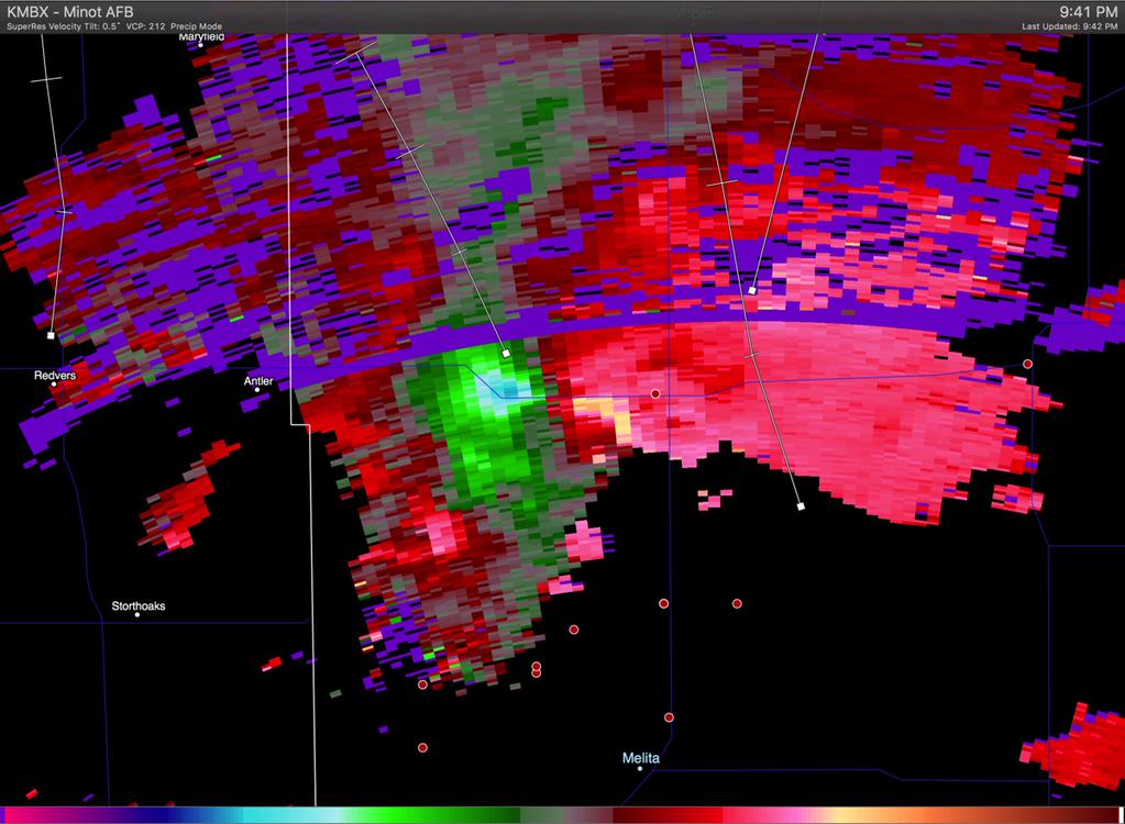
The tornado continued to grow in size & intensity as it continued northeastwards. As the supercell continued to organize itself, extremely impressive velocities began to show up on doppler RADAR:
Doppler Velocities from the Minot AFB NEXRAD Site at 9:41PM CDT
Despite the height of the RADAR beam in the storm at this time, this velocity couplet1 clearly indicated a major event underway. As it progressed to the northeast, the storm developed into a large, multi-vortex tornado:
There’s no question that this tornado was one of the more powerful tornadoes in Canadian history.2 While the tornado was on the ground near Tilston, it grew into a massive circulation that had multiple tornadoes embedded within it:
Shortly after this stage, the tornado became rain-wrapped.3 Tracking various reports alongside the velocity couplet visible on doppler RADAR, the tornado-producing portion of the storm appears to have tracked from just southeast of Tilston north-northeastwards to between Reston and Cromer. It then took a slight jog eastwards and tracked along a line from between Pipestone and Scarth to east of Virden to just south-southeast of Crandall. After this point, the circulation weakens and the storm loses it’s organized tornado-producing capacity.
[map autofit=”1″ disable_scrollwheel=”1″]
[pin tooltip=”Carnduff, Saskatchewan” description=”The storms that eventually developed into the massive tornado-producing supercell initiated just east of Carnduff, SK.”]Carnduff, Saskatchewan[/pin]
[pin tooltip=”Tilston, MB” description=”Just outside of Tilston, MB was where a massive multi-vortex tornado that shocked storm chasers touched down on Monday evening.”]Tilston, Manitoba[/pin]
[pin tooltip=”Reston, MB” description=”The large, multi-vortex tornado passed just west of Reston, MB.”]Reston, Manitoba[/pin]
[pin tooltip=”Cromer, MB” description=”The large, multi-vortex tornado was seen southeast of Cromer, MB.”]Cromer, Manitoba[/pin]
[pin tooltip=”Pipestone, MB”]Pipestone, Manitoba[/pin]
[pin tooltip=”Scarth, MB”]Scarth, Manitoba[/pin]
[pin tooltip=”Virden, MB”]Virden, Manitoba[/pin]
[pin tooltip=”Crandall, MB”]Crandall, Manitoba[/pin]
[/map]
The thunderstorm’s circulation was not completely consistent throughout, though, and showed signs of cycling. This means that instead of one tornado being on the ground for a long time, it likely produced several tornadoes and had periods with no tornado present. There is no question, though, that when it was on the ground, it was a historic event. A simple sign of how intense it was? Reed Timmer, someone who has made a living off planting himself in the middle of some of the largest tornadoes the United States has seen, showed noticeable anxiety as his team got close to this tornado. As a caution, this video contains strong language.
Clean-Up Underway
Little in the way of damage was observed on Monday night; with the tornado occurring so late in the day. There were a few early indicators that this tornado was very strong, including asphalt ripped right off a bridge:
— Lana at SE Research Farm (@SE_ResearchFarm) July 28, 2015
For now, the clean-up continues for the few people that were affected by it and the rest of us can be thankful that, somehow, this long-tracked tornadic thunderstorm managed to miss almost all population centers in the region.
At 5:38PM CDT on Wednesday, July 29th 2015, Environment Canada issued a preliminary rating of a high-end EF2 to the Tilston tornado:
AWCN11 CWWG 292238
WEATHER SUMMARY FOR SOUTHERN MANITOBA ISSUED BY ENVIRONMENT CANADA AT 5:38 P.M. CDT WEDNESDAY 29 JULY 2015.
ON THE EVENING OF JULY 27, 2015, A TORNADIC SUPERCELL DEVELOPED NEAR PIERSON TRACKING NORTHEASTWARDS TO VIRDEN BY 11:00 PM. THE STORM EXHIBITING STRONG ROTATION ON RADAR FOR OVER TWO HOURS AND PRODUCED A LARGE VIOLENT TORNADO NEAR TILSTON, MANITOBA.
THE FOLLOWING IS A PRELIMINARY SUMMARY OF THE TILSTON TORNADO. FURTHER INFORMATION WILL FOLLOW FROM THE ON-SITE ASSESSMENT BY ENVIRONMENT CANADA METEOROLOGISTS.
PRELIMINARY STORM ASSESSMENT:
EVENT TYPE: TORNADO
START TIME: JULY 27, 2015 8:30 PM CDT
PRELIMINARY RATING: HIGH END EF2
LOCATION: NEAR ROUTE 254 BETWEEN PIERSON AND TILSTON
ENVIRONMENT CANADA METEOROLOGISTS CONTINUE TO SURVEY THE AREA AND ARE ACTIVELY SEEKING PICTURES OF THE TORNADO OR DAMAGE IT MAY HAVE CAUSED. SHOULD YOU HAVE ANY INFORMATION REGARDING THIS EVENT, OR TO REPORT SEVERE WEATHER AT ANY TIME, PLEASE CALL 1-800-239-0484 OR SEND AN EMAIL TO STORM(AT)EC.GC.CA.
PLEASE NOTE THAT THIS SUMMARY MAY CONTAIN PRELIMINARY OR UNOFFICIAL INFORMATION AND DOES NOT CONSTITUTE A COMPLETE OR FINAL REPORT.
END
This may be changed in the future as more information becomes available to Environment Canada. As we said earlier, with the EF scale determined by damage, and with the Tilston tornado moving over such a sparse area, there may be insufficient evidence to rank how strong it actually was.
Chase Diary #1: Matthieu Desorcy
Part of the A Weather Moment team went out to storm chase on Monday. Here’s how the day unfolded in his own words.
Storm Chase Log – July 27, 2015 by Matthieu Desorcy
Well, it was quite the chase day in southeast Saskatchewan and southwestern Manitoba. It all started off leading into the weekend when models began showing some tornado potential and there was fairly good consistency between runs in the region of concern. A few of us, including another AWM member – Scott Kehler, decided to take the day off make the drive out west and go chasing.
On the morning of July 27th, our group left Winnipeg around 10:30AM make our way to southeast Saskatchewan, where we expected storms to initiate. The setup looked promising from the get-go early in the morning as most of the MCS activity stayed well north of our target area and little cloud prohibited surface heating from happening, allowing the warm front to lift into southeast Saskatchewan. Not knowing exactly which town we were targeting, we headed down along highway 2 all the way to Souris to start off where we had our usual chase day lunch – Subway. Knowing that the cap would hold strong until early evening, we weren’t in a huge rush to get to southeast Saskatchewan. We made a quick analysis which revealed by early afternoon the warm front was already across the border and was visible as a fine line on Foxwarren radar as well as Glasgow radar, stretching from southwest to northeast. We then decided to head to Redvers, SK, which was located just south of the warm front.
Inflow winds were gusting into the storm at a speed of an estimated 70-80km/h – the strongest inflow I’ve ever felt.
When we arrived in Redvers it was obvious the warm front was nearby – the wind came from the east southeast and the air felt “chillier” than just to the south in Carievale, SK. After observing several attempts of towering cumulus trying to break the cap, then moving north of the warm front and dying off near Redvers the setup suddenly wasn’t looking too promising. The cap was holding strong. Resisting the urge to relocate to another area further southwest we held strong in Redvers while getting a nice suntan and living from radar scan to radar scan.
It suddenly started to get exciting in the mid-evening. A few radar echoes began to show up south of Carnduff, SK near the international border which gave us hope the disturbed area would be able to get its act together and break the cap. In addition to the new echoes on radar, we observed some high level cirrus which implied that ascent was beginning to take place, associated with a shortwave we had identified earlier, moving into the region. This would give storms the extra push they needed to break the cap.
Echoes steadily strengthened from scan to scan and finally it was obvious that the storm had broken the cap – it had tops exceeding 50,000 feet. We watched the storm as it grew and slowly moved northwards, organizing itself and finally producing the first wall cloud of the day – the chase was on. Around 7:30PM the wall cloud really beefed up in the same area – a bowl formed and one side of the wall cloud was rising rapidly into the updraft. After watching it for a good 20 minutes the storm had appeared like it gusted itself out, the wall cloud disappeared and the base was higher. Taking advantage of the opportunity and knowing that nothing was imminent, we relocated to a location just north of Gainsborough, SK. Here we watched it for another 20 minutes as the supercell cycled wall clouds and produced what appeared to be a funnel.
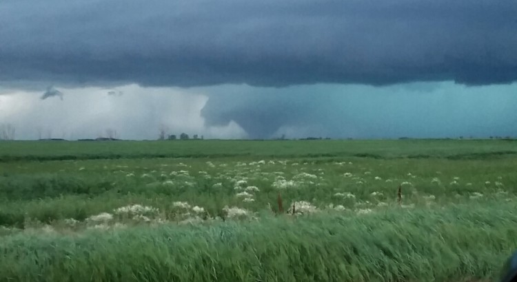
Storm in its initial stage 5km west of Clairevale around 7:30PM CST.
Tornado on the ground near Tilston, MB.
Large wedge tornado on the ground near Tilston, MB.
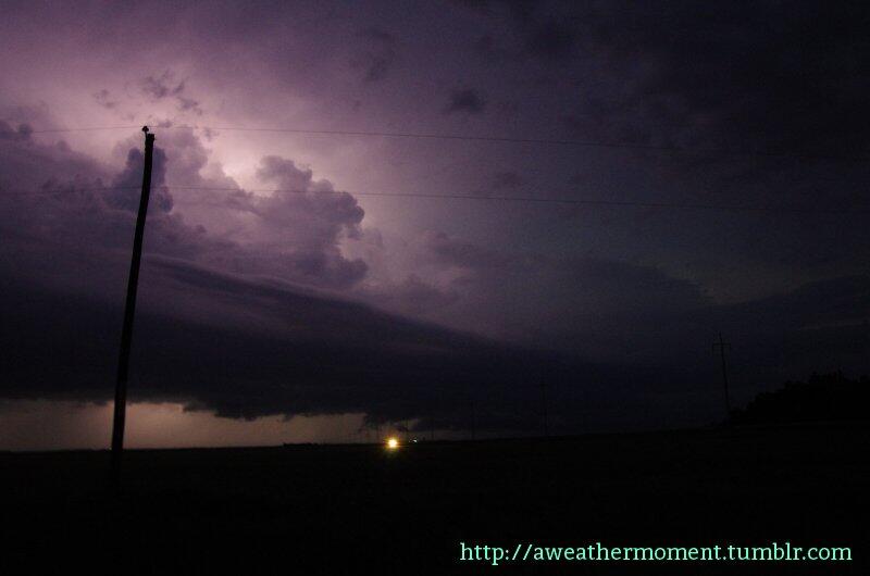
Lightning captured from the Tilston, MB supercell.
As the storm slowly moved north northeast it moved away from us – we once again repositioned, this time on the Manitoba side, to the southeast of the storm not too far from Pierson, MB. This is when we noticed that things were really getting serious and potentially dangerous for surrounding communities. Minot radar showed that the storm had really tightened up its rotation. Once we were able to stop and take a close look at the storm. We noticed that a tornado was already in progress – and a large one that that, around 8:30pm northwest of Melita. We watched it for a good 20 to 30 minutes in the middle of nowhere in southwestern Manitoba northwest of Melita, snapping pictures amazed at what we were seeing a wedge tornado, here in the province of Manitoba. Inflow winds were gusting into the storm at a speed of an estimated 70-80km/h – the strongest inflow I’ve ever felt. It was obvious that the storm was moving away from us so we decided to move once again, this time to the north of Melita. By this time (9:20pm) we could not see the tornado anymore but the tornado could have been rain-wrapped. We cautiously watched the storm from the comfort of our car as cloud to ground lightning intensified and positive strikes coming out of the anvil peppered the area just to our north. By this time it was getting dark and the circulation would have been rain-wrapped – we watched the storm for a while longer and decided to call it a day as it was getting too dangerous to chase in the dark.
This was one of the stronger storms any of us had ever seen in person and will be a chase to remember for a long time to come!
Chase Diary #2: Justin Hobson
In addition to Matt, friend of the site Justin Hobson was also out chasing that day. Here’s what he experienced:
Tilston, MB Chase Log by Justin Hobson
We started the day in Oxbow, Saskatchewan where we dealt with tropical conditions as temperatures shot up near 30 degrees with dew points in the low 20’s. A deepening low pressure system was located to the southwest of us over northeast Montana and winds increased out of the east throughout the afternoon. A warm front was anchored from the southwest to the northeast across extreme southeast Saskatchewan and storms started to fire around 6 pm where they then rapidly intensified. There was some cell interaction going on at first due to the forcing that came in but one supercell was able to survive and latch on to the warm front around 8 pm (Manitoba time) where it became tornadic over the next 2-3 hours.
We caught a glimpse of a brief rope tornado while driving around 8:25 pm. We kept heading north where we then witnessed a violent stovepipe tornado at about 8:30 pm. This stovepipe then transitioned into a multi-vortex tornado which then got wrapped in rain where it appeared to have dissipated. We then repositioned ourselves for the new occlusion just to the northeast of the old circulation. Shortly after, we saw another tornado develop which started off as a large cone. This cone tornado quickly wedged out and grew to about 1/2 mile in size. This wedge lasted for a few minutes before becoming rain-wrapped as the sun set. It then continued to move to the northeast very slowly for another hour or so towards the Virden/Oak Lake area. What a day!
A velocity couplet is a tightly packed region of velocities directed towards the RADAR site and away from the RADAR site. If oriented properly, they indicate rotation of a thunderstorm.↩
While it’s incredibly fortunate that it appears the tornado-producing part of the storm managed to miss practically every town and settlement in the region, it may mean that there isn’t sufficient evidence to fully assess the strength of the tornado. The EF scale is dependent on damage, and if the tornadoes didn’t pass over many structures to damage, it may have to be rated lower than its actual strength despite strong visual cues that suggest otherwise.↩
Rain-wrapped means that the precipitation from the thunderstorm has literally wrapped all the way around the tornado, obscuring it from view.↩
Southern Manitoba will be under the influence of a complex low pressure system this weekend that will spread multiple bands of precipitation across the province. Things are a little uncertain for Sunday – Father’s Day and the Manitoba Marathon – but it’s looking probable that it may be quite wet.
Friday
21°C / 12°C
Increasing cloud; chance of afternoon showers. 5-10mm of rain overnight.
Saturday
18°C / 14°C
Cloudy; some light rain or drizzle possible.
Sunday
18°C / 10°C
Rain likely; up to 20mm.
Today will be a relatively nice day. Cloud coverage will gradually increase and there will be a slight chance of showers in the Red River Valley this afternoon as rain spreads eastwards across southern Manitoba. The temperature will climb to around 21°C.
Showers will move into the Red River Valley through the evening with around 5-10mm falling. While there may be an odd rumble of thunder, overall the thunderstorm threat is low to non-existent. Rain will move from southwest to northeast and lift into the Interlake region, leaving us with overcast skies by morning. The low temperature will sit near 12°C.
Total expected rainfall for the first wave of rain today through tonight into Saturday morning.
Saturday will be a mainly cloudy day with some showers or drizzle likely. It doesn’t look too wet, but overall it will be sort of a dreary day with sporadic precipitation. Further north, through the Parkland region eastward into the Interlake, there will likely be rain for much of the day. The high temperature will be near 18°C and expect the temperature to drop to around 14°C on Saturday night.
Uncertain Sunday
Sunday, which marks Father’s Day and the ever-popular Manitoba Marathon, has a little more uncertainty associated with it. The general weather picture shows a stalled out low pressure system over SE Saskatchewan and SW Manitoba while a Colorado low lifts northwards through the Dakotas. The evolution of the feature is very complicated, and small changes in the upper-level flow could mean big changes to the expected weather over Southern Manitoba. I’ll give the most likely solution right now, and leave updates in the comments below if it looks like an alternate solution becomes more plausible.
The GDPS is forecasting a very wet Sunday with 10-20mm of rain through many areas of Southern Manitoba.
Sunday morning will provide a cloudy start to the marathon with some scattered showers or drizzle about. The temperature should be around 15°C. By mid-day, more concentrated shower activity will push northwards through the Red River Valley, with an area of rain covering much of southern Manitoba (save for locations near the Saskatchewan border) by early-to-mid afternoon.
The rain will persist into the evening and taper off by Monday morning. Total rainfall amounts are quite variable, but overall it seems like 10-25mm is possible in most regions, with higher amounts near the US border through SE Manitoba and along the western escarpment of the Red River Vally northwards into the Riding Mountains. Anywhere from 25-40mm seems possible in these areas.
The temperature will drop to around 10°C on Sunday night after the rain tapers off.
Unsettled Pattern Continues
Next week is looking fairly unsettled as yet another major disturbance takes up residence on the Prairies. In general, more cloud than sun will be seen through the week. Heavy rainfall will set up in Alberta on Monday, and as the system develops it looks like a large area of convection will develop across the Northern Plains and lift northwards into the southern Prairies, including Winnipeg and the Red River Valley, by mid-week.
It’s a long ways off, though, so we’ll take a closer look later in the weekend when things become a little more clear.
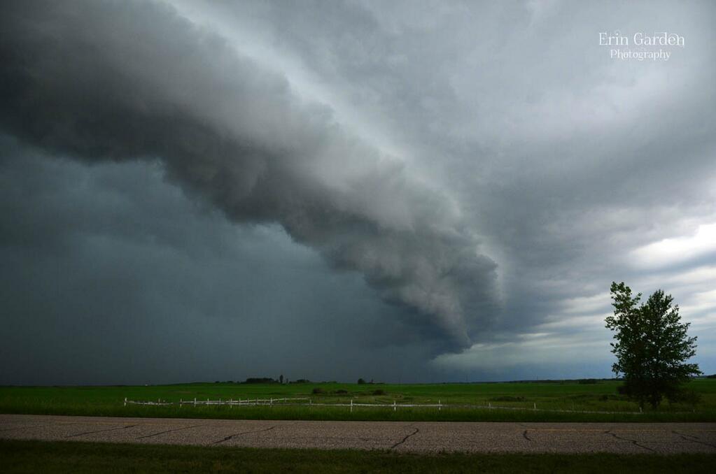
Things will gradually calm down after a wild night in Winnipeg which saw a highly developed squall line move through the city. Fuelled by the heat and humidity that built up over southern Manitoba through the day, it started as a few severe thunderstorms that fired along a trough line in SE Saskatchewan and SW Manitoba then quickly developed into an impressive line of storms that raced eastwards across the Red River Valley.
Photo of a shelf cloud on a supercell in Southern Manitoba on Tuesday afternoon. Credit: @Erin_Shutterbug
Initially the storms brought golf ball sized hail and torrential downpours to southwestern Manitoba. The village of Reston, MB received 104mm of rain in just 3 hours. This was in addition to the nearly 200mm of rain they received on Friday night and then the 25–50mm of rain the region on Sunday as rain moved through the region, bringing their week total to over 300mm. With devastating flooding in the region, officials do no recommend travel in the area. They are looking for volunteers to help with sandbag and pump efforts; volunteers can register with the R.M. of Pipestone Municipal Office at (204) 877–3327. Some highways in the area are closed due to overland flooding.
Photo of the squall line as it approached Winnipeg on Tuesday night. Credit: @lovestormsMB.
Here in Winnipeg, the storm rolled in around 10:50PM as near-constant lightning filled the skies. A very menacing looking squall line promptly pushed in producing winds as high as 90–100km/h that ripped through the city snapping some tree branches and producing some localized power outages mainly on the south side of the city. Rain hammered down with the central and southern parts of the city seeing 20mm of rain in under an hour. Northern parts of the city received a little less rain, only getting around 5–10mm with the initial line of storms. A large area of stratiform precipitation moved in and brought another 5–10mm of rain to the city through the night.
Things will slowly dry out and stabilize over the next few days as an upper ridge slowly builds over the Rocky Mountains.
Today & Tomorrow
Wednesday 27°C / 17°C Warm and humid; afternoon clouds with scattered showers. Risk of a thundershower.
We’ll see some afternoon clouds today as the sun warms us up and destabilizes the lower atmosphere. Some scattered showers will develop with the risk of some thunderstorms as a shortwave pushes into Southern Manitoba coupled with a strong upper-level jet running along the International Border. There is little threat of severe storms today, but given the high dew points any thunderstorms that develop may produce quite intense downpours. They should move along at a decent speed today, though, so no one place should see too much rain. We’ll see a high around 27°C today.
Thursday 27°C / 15°C Afternoon clouds with a chance of showers.
We’ll drop down to around 17°C tonight with skies gradually clearing.
Tomorrow will bring another warm day with some afternoon clouds and a slight chance of afternoon showers. Winds will pick up out of the northwest to 30 or 40km/h which will help push some of the moisture out of the Red River Valley and drop the humidity down to something a little more comfortable.
Friday
Friday 23°C / 13°C Increasing cloud. Chance of rain overnight.
Friday will bring increasing cloudiness as an upper trough begins slumping southwards from the central/northern Prairies. It looks like any rain will hold off until the overnight period, and if it does end up moving in, amounts won’t be anything too extreme. At this point, it seems like only around 5mm would be likely. There would be no threat of thunderstorms with this system.
The weekend is looking pleasant with plenty of sun and highs around 25°C.