Blazing Heat Building In

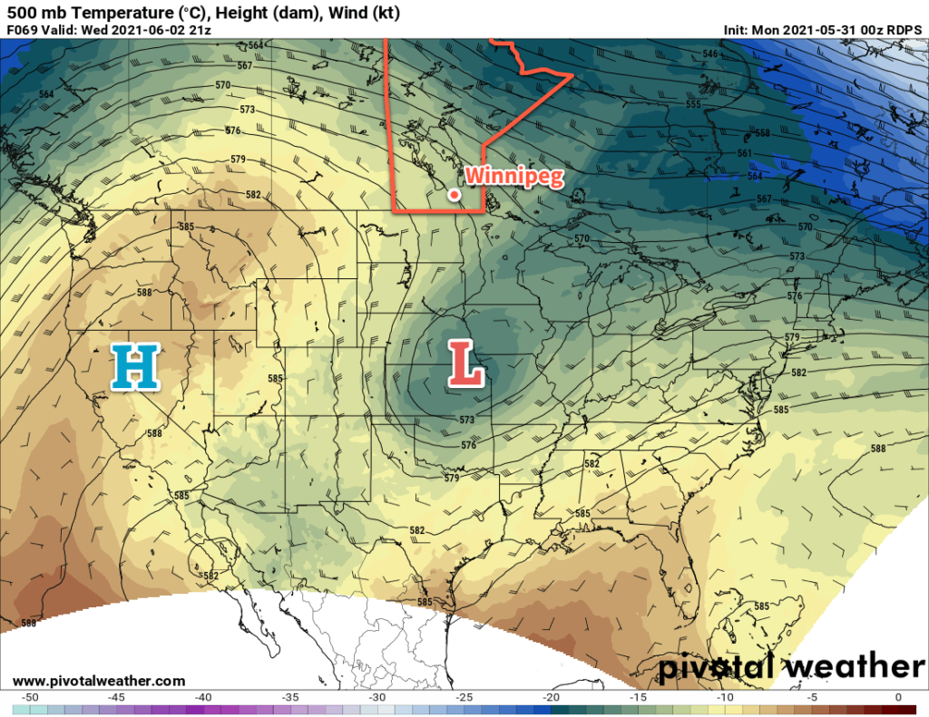
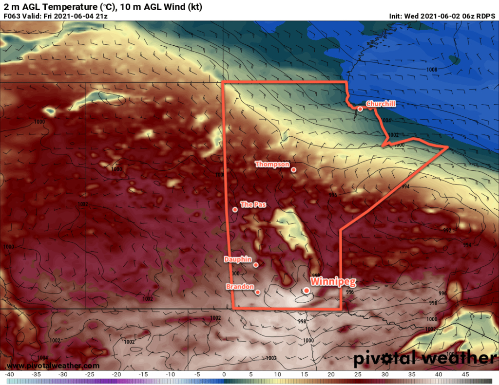
Temperatures will soar in Winnipeg through the second half of the week as a potent upper ridge builds across the Prairies.

The heat will be remarkable for early June as temperatures climb through the 30s over the next few days. The heat will likely challenge records for the Winnipeg area, particularly on Thursday and Friday. Thursday’s high of 33 °C will challenge the existing record of 32.8 °C set in 1968. Friday’s intense push of heat will send highs into the upper 30s and likely break the existing record high of 35.6 °C set in 1988. The overnight lows may even challenge record warm minimum temperatures which sit at 18.3 °C for both June 4th and 5th, set in 1976.

Environment and Climate Change Canada has issued a heat warning for much of southern Manitoba. Tips to beat the heat can be found on the City of Winnipeg’s emergency preparedness page.

RDPS 2m Temperature Forecast valid 21Z Friday June 4, 2021
Temperatures will be very hot over southern Manitoba on Friday with highs in the 35–40 °C range.

The city will see plenty of sun throughout the next few days. The most notable non-heat element of the weather will occur overnight into early Thursday morning. A strong upper-level jet will generate some showers and/or thunderstorms over the northern Prairies on Wednesday afternoon. This cluster of instability will move southwards into southern Manitoba through the evening and overnight hours. Winnipeg will see a chance of showers or thunderstorms overnight with the highest chance after midnight. These storms won’t have any organized risk of severe weather, but dry low-levels mean that some moderate to strong wind gusts will be possible with them as they move through.

Some lingering cloud from these systems will stick around on Thursday morning, then skies should clear for the afternoon.

Long Range Outlook

The heat will continue with daytime highs in the 30s on Saturday, then highs will ease back into the upper 20s Sunday into next week. Conditions will also turn more unstable this weekend, with an increasing chance of showers or thunderstorms beginning Sunday night and persisting into next week. The above-seasonal warmth will persist right through next week with highs in the mid- to upper-20s and lows of 15–20 °C.

Today’s seasonal daytime high in Winnipeg is 22 °C while the seasonal overnight low is 9 °C.

Heading Into A Heat Wave

Winnipeg will see temperatures soar this week as scorching heat builds into the region.

Winnipeg will see plenty of sunshine over the next few days as an upper ridge builds into western Canada. On Tuesday, a weak low moving through southern Manitoba will bring a few more clouds into the region. As it slumps southwards, it will bring a chance for scattered showers or thunderstorms. The support for thunderstorms will be weak — bulk shear will sit at 20–30 knots and try to offset the limited energy — but there will likely be enough forcing to support a few. Skies will clear out again for Wednesday.

RDPS 500mb Wind and Temperature Forecast valid 21Z Wednesday June 2, 2021
A potent upper ridge will build out of the western United States into the Canadian Prairies this week.

The big story will be the building heat this week. As the upper ridge strengthens over the Prairies, Winnipeg will see daytime highs rise from the low 20s today to around 30 °C by Wednesday. Overnight lows will follow suit increasing into the upper teens by mid-week.

Long Range Outlook

The heat will continue to build through the latter half of the week. Daytime highs should peak on Friday in the mid- to upper 30’s as overnight lows stay in the upper teens. Fortunately, dew points are forecast to stay in the low to mid-teens, so humidex values won’t be a significant component of the heat wave. The hot weather will continue into the weekend, then begin to ease as unsettled conditions develop on Sunday into next week.

Today’s seasonal daytime high in Winnipeg is 22 °C while the seasonal overnight low is 8 °C.

Mild Spring Weather Arrives

Winnipeg will enjoy pleasant spring weather with seasonably mild temperatures and a chance of showers.

Winnipeg will see warmer weather move in today as a weak area of low pressure builds east across the Prairies. Temperatures will climb to a high near 22 °C this afternoon with southerly winds into the 20–30 km/h range. Skies should stay mostly sunny through the day. It will continue to be dry; with warm weather and dew points between -5 and -10 °C, the relative humidity will drop into the 10–20% range for the afternoon. A few clouds will linger overnight as a continued southerly flow brings warmer air with a bit more moisture into the region. Winnipeg should see a low near 9 °C. There’s also a slight chance that a few showers may drift across the region overnight.

RDPS 2m Temperature Forecast valid 21Z Thursday May 13, 2021
Summer-like warmth will spread across southern Manitoba on Thursday.

Thursday will be a beautiful day across many parts of the Red River Valley. Winnipeg will see a high near 24 °C with partly cloudy skies as the broad area of low pressure continues to build into the province. Dew points will be higher on Thursday, climbing above 0°C and into the low to mid single digits. While this isn’t particularly remarkable on its own, it will be a 10–15 °C increase from Wednesday. One thing that the higher dew points will allow for, though, is the likely development of some scattered showers in afternoon. Although there isn’t too much instability, an isolated non-severe thunderstorm may be possible as well.

Things will taper off in the evening with temperatures in Winnipeg heading to a low near 9 °C under partly cloudy skies.

RDPS 48-hour Accumulated QPF Forecast valid 00Z Saturday May 15, 2021
Many places across southern Manitoba will see a chance of scattered afternoon showers on Thursday and Friday.

Friday will bring much of the same to Winnipeg again with a high near 22 °C and partly cloudy skies. Some scattered showers will once again be possible in the afternoon with the risk of an isolated non-severe thunderstorm. Temperatures will dip to a low near 7 °C on Friday night with a few lingering clouds.

Long Range Outlook

Spring arrives, as they say, slowly and suddenly. While a prolonged cool pattern only came to an end yesterday, now it looks like Winnipeg will be seeing nothing but warmth for the next week. Highs of 20–25 °C are forecast well into next week with overnight lows in the upper single digits or low teens. The warmer overnight lows, in particular, should help the growing season get started across the region.

Several disturbances will move through the region through the next week, bringing a couple chances of rain with them.

Today’s seasonal daytime high in Winnipeg is 19 °C while the seasonal overnight low is 5 °C.

Pleasant Start to the Weekend, Rainy End

After unsettled weather moves through this morning, Winnipeg will enjoy a pleasant start to the weekend. On Sunday, unsettled weather will return as the next disturbance moves into the province.

Today will start with a cold front pushing through the region early this morning. As it moves through, it will push a line of showers and thunderstorms southeastwards across the region. Behind them, skies will clear and northwesterly winds will strengthen into the 30–40 km/h range for the rest of the day. These winds will usher in a return to seasonal temperatures and Winnipeg will see a high of just 22 °C this afternoon.

A ridge of high pressure moving into the province will bring cooler temperatures into the province tonight. Winnipeg will see a low near 10 °C under clear skies with winds gradually easing.

That ridge will also give Winnipeg plenty of sunshine on Saturday. With light winds and mainly sunny skies, the city will see temperatures climb to around 23 or 24 °C. Heading into Saturday night, an approaching complex of low pressure will strengthen southeast winds into the 20–30 km/h range. These winds will help keep temperatures a bit milder with a low near 13 °C.

On Sunday, the approaching disturbance will spread cloud into the region as temperatures climb to a high near 23 °C. Forecasts show a broad area of rain developing in the afternoon, producing widespread amounts of 10–25 mm of rain across the Red River Valley by the time it tapers off overnight. Locally higher amounts may end up possible depending on how much elevated instability develops over the region.

NAM 24hr. Precipitation Accumulation Forecast valid 12Z Monday August 31, 2020
Much of southern Manitoba is forecast to see accumulating rainfall on Sunday afternoon and night.

Along with the rain, it will be a breezy day as well. The southeasterly winds will persist through the day before switching to the northwest in the evening behind a passing cold front.

Temperatures will dip to a low near 11 °C on Sunday night under mostly cloudy skies as the rain tapers off.

Long Range Outlook

Next week looks to bring a spell of seasonably cool weather. Winnipeg will see mixed skies through the week with daytime highs in the upper teens or low 20s. Overnight lows look to hover near a seasonal 10 °C. Some rain is possible mid-week as a couple disturbances are forecast to move through southern Manitoba.

Today’s seasonal daytime high in Winnipeg is 23 °C while the seasonal overnight low is 10 °C.