Summer Heat Going Nowhere

Winnipeg will see slightly cooler temperatures today, but the sweltering heat will build right back into the region.

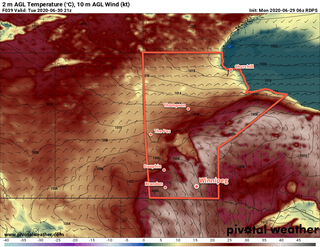
Temperatures will be a few degrees cooler in Winnipeg today behind a cold front that moved through overnight. Rather than the highs in the low 30s seen over the past few days, the city will “only” reach around 28°C. One notable difference will be that the humidity will ease into the mid-teens making things a little bit more comfortable. The city will see a bit of lingering cloud this morning with a chance of a shower or two, then skies will clear in the afternoon. It won’t be too windy, either, with southerlies near 20 km/h.

Unfortunately, there won’t be much relief for in the overnight lows. Warmer air will already be building back into the region tonight as the upper ridge begins rebounding into the region. The city will see a low near 17°C.

RDPS 2m Temperature Forecast valid 18Z Thursday July 2, 2020
Hot, increasingly humid weather will return to the region on Thursday.

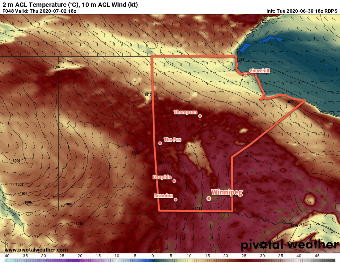
Thursday and Friday will bring plenty of sunshine to the region with temperatures climbing back into the low 30s. The humidity will surge back as well, sending humidex values back into the upper 30s. The wind will be more prominent on Thursday out of the south at 30 gusting 50 km/h, but Friday should bring calmer conditions with light southerlies.

For both nights, lows will head back into the 20 to 23°C range. The risk of thunderstorms – with severe weather possible given the hot and humid air mass – will return on Friday night for much of southern Manitoba.

Long Range Outlook

The upper ridge will begin to collapse on the weekend, replaced by a west-southwest flow aloft. This will continue to keep temperatures warm, but it’s likely the region will end up seeing a bit more cloud with occasional chances for showers or thunderstorms. Conditions will settle next week with generally sunny conditions.

No notable break in the heat is in the forecast. The humidity levels are forecast to ease slightly for next week, but the city will continue to see daytime highs in the 28 to 31°C range and overnight lows of 18 to 20°C.

Today’s seasonal daytime high in Winnipeg is 25°C while the seasonal overnight low is 13°C.

Sweltering Summer Heat Continues

Hot, humid weather continues in Winnipeg this week with a chance of thunderstorms on Wednesday.

The upper ridge that has brought a hot and humid air mass to the province isn’t going anywhere any time soon. As a result, neither will the heat. Temperatures over the next couple days will continue to climb into the low 30s during the day and dip to the low 20s at night. Along with this heat, dew points in the low 20s will produce humid conditions with humidex values climbing towards 40.

Winnipeg will see a bit of cloud over the next couple days with winds out of the southeast at 20 to 30 km/h.

RDPS 2m Temperature Forecast valid 21Z Tuesday June 30, 2020
Hot, humid conditions will continue over southern Manitoba on Tuesday.

On Wednesday, a “cold” front will push across the region, bringing more cloud and some showers with the risk of a thunderstorm. Given the hot and humid air mass in place, there will likely be a risk for severe thunderstorms in the region. What exactly it will look like, though, will depend significantly on the evolution of the system over the next two days as it brings more rounds of severe thunderstorms to southeastern Saskatchewan and southwest Manitoba.

Long Range Outlook

Temperatures will cool slightly behind the cool front on Wednesday, but the heat quickly returns for Friday into the weekend. Highs will climb back into the low 30s with humidity returning to the region. It appears that a reprieve from the heat (or at least the humidity) is likely after the weekend.

Stay safe and enjoy the summer weather as best you can!

Today’s seasonal daytime high in Winnipeg is 25°C while the seasonal overnight low is 13°C.

Warm Weather Returns; Thunderstorms Possible Thursday

Winnipeg will see warm summer temperatures return with a good chance of thunderstorms on Thursday evening.

Before any unsettled weather arrives in Winnipeg, the city will get to enjoy a beautiful summer day. Under sunny skies, temperatures will climb to around 27°C with light winds. Thunderstorms moving into southwestern Manitoba overnight will spread some cloud into the Red River Valley as temperatures head to a low near 11°C.

The city will see mixed skies on Thursday as a low pressure system moves into the Red River Valley. There’s a slight chance of an early morning shower or thunderstorm as nocturnal convection weakens heading into the Red River Valley. Through the rest of the day, skies will likely err on the cloudier side. A southerly wind will develop to around 25 km/h as temperatures climb to a high near 28°C.

RDPS 2m Dew Point Forecast valid 00Z Friday June 26, 2020
Increasingly humid conditions will build into the province on Thursday.

Notably, the humidity will build on Thursday with dew points climbing into the upper teens. This moisture will help support a severe weather threat on Thursday evening as a low moves through. Moderate amounts of instability supported by favourable wind shear will support the development of scattered thunderstorms over western Manitoba in the afternoon. This activity will shift into the Red River Valley through the evening, quickly exiting with a slight chance of a few lingering showers overnight. Strong to severe thunderstorms are possible with primary threats of damaging hail and wind gusts.

Temperatures will dip to a low near 17°C on Thursday night with diminishing winds.

A few lingering showers are possible Friday morning, then Winnipeg will see mixed skies with some clearing later in the day. Temperatures will stay warm with a high near 27°C, but humidity levels will return to more comfortable levels. Winds will pick up out of the northwest into the 20 to 30 km/h range for the day, then ease in the evening. The city will see a low near 14°C on Friday night under clear skies.

Long Range Outlook

Through the weekend, a digging west-coast upper trough will build an upper ridge over Manitoba. As a result, hot weather will develop this weekend with highs climbing back over 30°C alongside gradually increasing humidity. Skies should stay on the sunnier side through the weekend.

Heading into next week, it’s looking as though temperatures will stay hot and humid! Unsettled conditions and several chances for showers or thunderstorms.

Today’s seasonal daytime high in Winnipeg is 24°C while the seasonal overnight low is 12°C.

Cooling Off But Remaining Unsettled

Winnipeg will see another hot and humid day capped off with a risk of thunderstorms before cooler temperatures move in.

Temperatures will again climb into the low 30s today in Winnipeg as southerly winds continue to pump heat northwards. The city has seen a bit of a break from the humidity overnight, but it will build back in through the day with dew points rising to around 20°C. A disturbance lifting northwards into the region this morning will bring a chance of showers later this morning into the afternoon. By late afteroon, activity will intensify with thunderstorms developing along a cold front pushing eastwards across the province.

Much of the Red River Valley and areas east will see a risk of severe thunderstorms this evening, but the greatest threat will be over southeastern Manitoba. The main threats in the Red River Valley will be large hail and damaging wind gusts. The thunderstorms should move eastwards out of the Red River Valley through the evening. Brisk southerly winds of 30 to 40 km/h today will ease in the evening.

For more details on the severe thunderstorm threat over southern Manitoba, refer to ECCC’s Thunderstorm Outlook on our Bulletin Viewer and watch for updated forecasts and/or any alerts issued today.

NAM 2m Dew Point Forecast valid 00Z Thursday June 18, 2020
A hot and humid air mass will provide fuel for a thunderstorm outbreak over southern Manitoba later today.

Much cooler conditions will arrive for Thursday with mixed skies and a good chance of showers. Temperatures will work towards a high of 22°C with west-northwest winds picking up to around 30 km/h. The region will see a good chance of showers as an upper low stalls over southern Manitoba. Any showers will taper off in the evening as temperatures head to a low near 9°C under partly cloudy skies.

The sluggish upper low will still impact the region on Friday with partly cloudy skies and a chance of showers. The high will be seasonably cool near 21°C with southwest winds of 20 to 30 km/h. Winnipeg should see a few clouds on Friday night with a low near 11°C.

Long Range Outlook

Cool and unsettled conditions will likely persist into the weekend with highs in the low 20s and a couple more chances for showers. Seasonal conditions will return next week with more settled conditions developing.

Today’s seasonal daytime high in Winnipeg is 24°C while the seasonal overnight low is 11°C.