Unsettled Summer Weather Ahead

Winnipeg will see mild temperatures through the first half of the week, but also several chances for showers or thunderstorms.

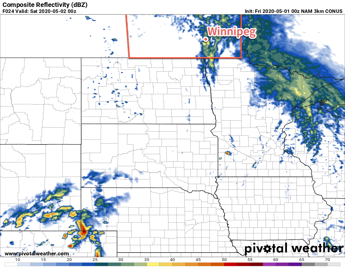
Today will start off with a few showers as a trough of low pressure moves through the region. The rain should clear out early in the morning, leaving increasingly humid conditions as temperatures climb into the mid-20s. A cold front will push through midday, bringing breezy westerly winds of 30 gusting 50 km/h that usher in drier air and clear out any remaining clouds. Temperatures will continue to climb to about 31°C this afternoon under mainly sunny skies. The winds will ease tonight as temperatures head to a low near 16°C with increasing clouds towards morning.

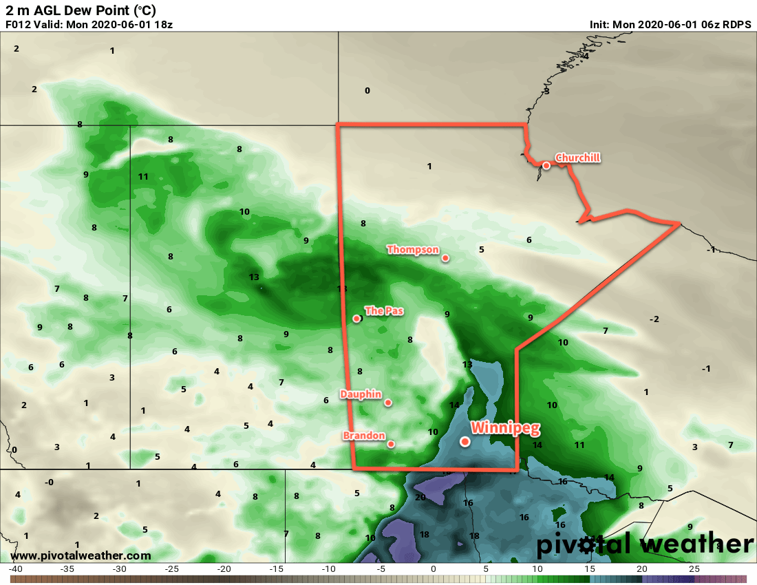
Tuesday will start with a disturbance tracking along the U.S. border that will likely spread showers across southern Manitoba. There will be a chance for these showers to have a few embedded thunderstorms as well. That activity will move out through the morning, followed by mixed skies with temperatures climbing to a high near 27°C. A cool trough pushing in from the northwest through the afternoon hours will bring another risk of thunderstorms to the region late in the day. Skies should clear out overnight as temperatures dip to a low near 12°C.

RDPS 2m Dew Point Forecast valid 18Z Monday June 1, 2020
Conditions will become a bit muggy by midday Monday, but a cold front will push drier air into the region for the afternoon hours.

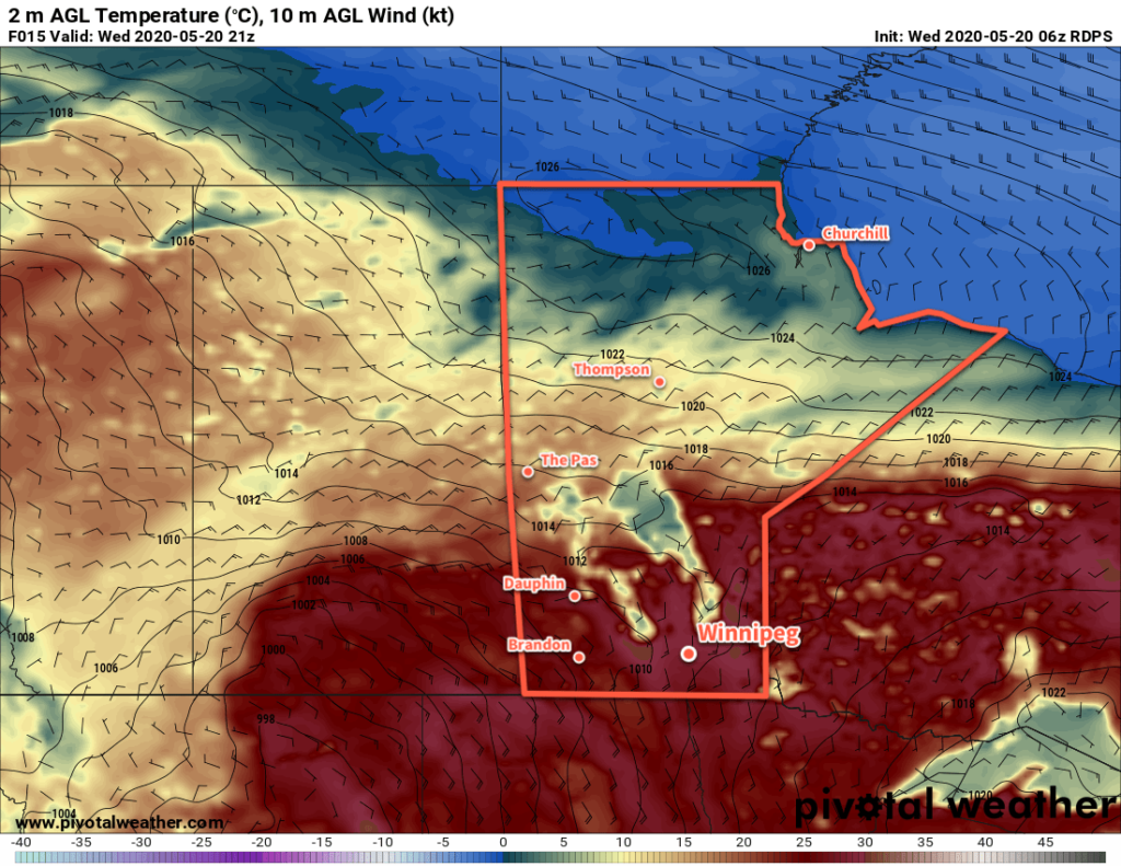
Wednesday will start off sunny, but then see late day clouds increase as another low pressure system moves into the province from Saskatchewan. Temperatures will climb to a high near 28°C with southerly winds in the 20 to 30 km/h range. A few showers or thunderstorms will be possible later in the day through the evening hours as well. Skies will clear out overnight with temperatures dipping to a low near 14°C.

Long Range Outlook

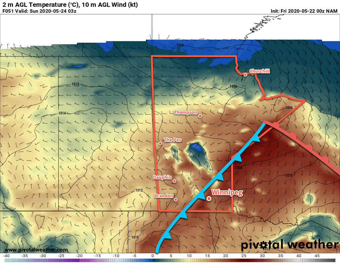
The weather will become more settled through the second half of the week with a return to seasonal temperatures. Heading through the weekend, however, it looks like conditions will turn significantly more unsettled as numerous low pressure systems begin to track across the region.

Today’s seasonal daytime high in Winnipeg is 22°C while the seasonal overnight low is 9°C.

Warm And Unsettled Weather Ahead

The warm summer temperatures will gradually cool back to seasonal values this weekend as a cold front pushing east brings unsettled conditions to the region.

Today will be a beautiful day in Winnipeg as temperatures head to a high near 27°C under partly cloudy skies. Winds will continue as they have the past several days, strengthening out of the south to 30 gusting 50 km/h. By late in the day, a chance of thunderstorms will develop over the southwestern corner of the province into the Interlake. Winnipeg may have a chance of seeing some activity, but it looks likely that it will stay west and north of the city. Temperatures will head to a low near 16°C tonight with southeast winds near 20 km/h and partly cloudy skies.

Saturday will bring mixed skies to the region with a good chance of showers and a chance of thunderstorms. Temperatures will climb to a high near 26°C with southerly winds of 20 to 30 km/h. In the evening, a cold front will begin moving across the Red River Valley. Moderate instability will develop ahead of the front, likely triggering a line of showers and thunderstorms as it moves through. The rain will move northeastwards along the front as it slowly crosses the Red River Valley. Lows will dip a bit cooler to around 13°C behind the front on Saturday night.

NAM 2m Temperature Forecast valid 03Z Saturday May 24, 2020
A cold front pushing across the Red River Valley on Saturday evening will bring a chance of showers or thunderstorms to the region.

On Sunday, a disturbance lifting northeastwards across North Dakota will spread cloud and showers into southern Manitoba. While the southern Red River Valley will see some rain, it’s less likely here in Winnipeg. Most guidance suggests that the rain will remain just south of the city with a chance of a few showers as it passes by. While there is good agreement on the current track, if the disturbance ends up a bit further north then it could be a rainy day for the city. Temperatures will climb to a near-seasonal high of 20°C with northerly winds of 20 to 30 km/h. Temperatures will head to a low near 11°C on Sunday night with cloud cover breaking up and winds easing.

Long Range Outlook

Next week is looking pleasant with seasonal to slightly above-seasonal temperatures. Winnipeg should see plenty of sunshine, but some unsettled weather may be possible midweek with a chance of showers or thunderstorms.

Today’s seasonal daytime high in Winnipeg is 21°C while the seasonal overnight low is 7°C.

Summer Heat Continues

Temperatures will soar in Winnipeg over the coming days as an early-season blast of summer heat moves through.

Temperatures will soar this afternoon in Winnipeg as southerly winds of 30 gusting 50 km/h continue to push heat out of the United States. Before it warms up, though, the city may end up seeing some cloudy periods this morning as an area of stratus cloud clips by the region. Once that leaves the region, temperatures will climb to a high near 28°C this afternoon. Temperatures will dip back down to mild low near 18°C tonight with southerly winds of 20 to 30 km/h.

Thursday will bring mixed skies to the city with continued southerly winds near 30 gusting 50 km/h. Temperatures will continue to be seasonably mild with ah high near 26°C. Late in the day, more cloud cover will move into the region bringing with it a slight chance of showers. Temperatures will head to a low near 16°C with mostly cloudy skies.

RDPS 2m Temperature Forecast valid 21Z Wednesday May 20, 2020
Summer heat will once again be in place over southern Saskatchewan and Manitoba today.

Slightly unsettled conditions will continue over the region on Friday. Skies will stay on the cloudier side as temperatures climb to a high in the mid-20’s. Friday will bring the first organized thunderstorm risk to the Red River Valley, although it may end up staying to the west near the escarpment and into the southwestern corner of the province. The city will likely see a chance of showers or thunderstorms through the day, though. Those unsettled conditions may end up persisting through Friday night as well. Temperature should dip to a low near 14°C.

We’ll end up taking a closer look at Friday’s thunderstorm potential in our next forecast post!

Long Range Outlook

Saturday should bring another day of warm temperatures, then a push of cooler air will move in for Sunday. The latter half of the weekend will see highs head back to the teens with a good chance of rain. Things rebound nicely for Monday and Tuesday, then more unsettled weather is possible mid-week.

Today’s seasonal daytime high in Winnipeg is 21°C while the seasonal overnight low is 6°C.

Showery Friday Brings Cooler Weekend

After showers move through on Friday, Winnipeg will see a seasonably cool weekend with more sunshine.

A low pressure system sliding across the province will bring cloudy and unsettled weather to Winnipeg today. Temperatures will be mild as southerly winds near 30 gusting 50 km/h send the high back up to around 20°C. The city will see a chance of showers through the day, but the most likely time will be as a cold front sweeps through later in the afternoon. An organized band of showers will sweep across the Red River Valley by the evening, bringing generally 2 to 5 mm of accumulation. There will be a slight chance of an embedded thunderstorm or two with this line, but there will be no organized threat of severe weather.

Winds will strengthen out of the northwest to 30 gusting 50 km/h tonight behind the cold front. By Saturday morning, temperatures will have dropped to a low near 6°C with some clearing pushing into the Red River Valley.

3km NAM Simulated Composite Reflectivity valid 00Z Saturday May 2, 2020
Model forecast simulated RADAR images reveal the band of showers that will sweep across the Red River Valley on Friday evening.

On Saturday, skies will continue to clear while the moderate northwesterly wind continues. Temperatures will be cooler with a high of 13°C. A ridge of high pressure moving in on Saturday night will send temperatures to a low near -1°C with northerly winds of 20 km/h.

The winds will gradually ease on Sunday as Winnipeg heads to a high near 9°C with light northeasterly winds. The city will see plenty of sunshine with just a few clouds around. On Sunday night, a bit of cloud will push towards the region ahead of the next low pressure system heading this way. Temperatures will dip to a low near +1°C.

Long Range Outlook

Some cloudier, unsettled, and warmer weather will return to start next week, then looks like Winnipeg will settle into a slightly cool pattern for the rest of the week with variable cloudiness. No major rain is in the forecast.

Today’s seasonal daytime high in Winnipeg is 16°C while the seasonal overnight low is 2°C.