Fall-Like Weather Moves In

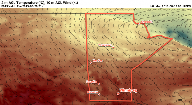
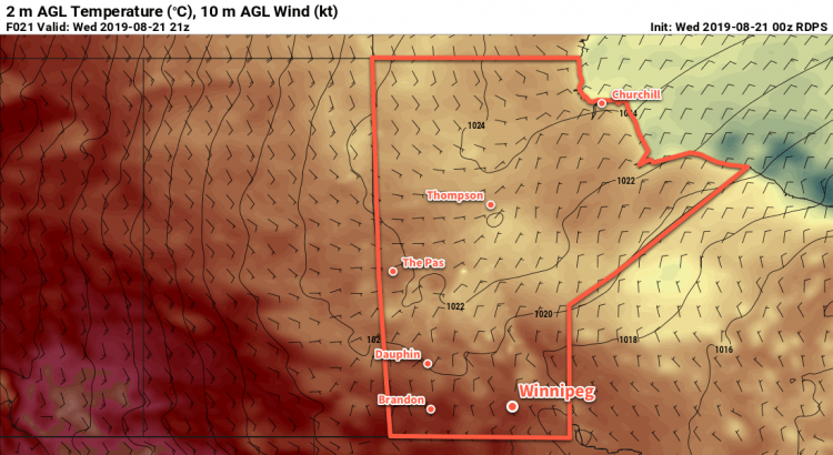
An Arctic ridge will bring chillier, fall-like conditions to Winnipeg over the next few days.

Cooler temperatures will be in place this morning across southern Manitoba as an Arctic ridge continues its trek across the province. The city will see sunshine give way to some afternoon cloudiness today with breezy north-northwest winds near 20 km/h. Temperatures will be cool with a high of just 20°C. The clear skies will continue tonight with a low near 6°C and diminishing winds.

On Thursday, more seasonal temperatures will return to the region as the Arctic ridge moves off into Ontario. Winnipeg should see a high temperatures near 23°C with a southeasterly wind near 20 km/h developing in the afternoon. Skies will stay mainly sunny through the day. The city will see a few clouds overnight as temperatures dip to a low near 12°C.

Cloud cover will push in early on Friday as a large trough of low pressure moves towards the region. It will be a moderately windy day with southerlies into the 30 gusting 50 km/h range developing in the morning. Temperatures will climb into the mid-20s before showers spread into the region in the afternoon. The chance for showers–along with a slight risk of a thunderstorm–will continue right through the night. Winnipeg will see a mild low on Friday night near 17°C.

Long Range Outlook

A rather unsettled weekend is on tap for much of southern Manitoba. The slow-moving upper trough is forecast to produce several rounds of showers and/or thunderstorms over the region Friday night through Tuesday. Temperatures look to hover near seasonal values with southerly winds on Saturday turning northwesterly for the first half of next week.

Today’s seasonal daytime high in Winnipeg is 24°C while the seasonal overnight low is 11°C.

Sunny and Seasonably Cool Weather Ahead

Winnipeg will see plenty of sunshine over the next three days with daytime highs falling into the low 20s.

It will be a beautiful start to the week in Winnipeg as temperatures climb to a seasonal 25°C under plenty of sunshine. A weak ridge of high pressure over the region will keep winds light as well; the city will see generally westerly winds of 10 to 20 km/h.

An approaching low will trigger a few showers and/or thunderstorms this afternoon over western parts of the province. Heading into the evening, this area of instability will shift eastwards into the Red River Valley, bringing scattered showers with a risk of thunderstorms later in the evening. This activity should clear out overnight with temperatures dipping to a low near 13°C.

Any remaining cloud will clear out early Tuesday morning as a ridge of high pressure builds in from the northwest. This ridge will bring the city plenty of sunshine over the next couple days with highs in the low 20s. Winds will be breezy out of the northwest both days; Tuesday should see them strengthen to 30 gusting 50 km/h followed by lighter winds on Wednesday of 20 to 30 km/h. Both nights will bring lows in the high single-digits.

Long Range Outlook

Temperatures should rebound back to seasonal values for Thursday as the ridge moves off to the east. Heading into the weekend, it looks like a large upper trough will swing towards the region, bringing several chances for rain or thunderstorms through the weekend.

Today’s seasonal daytime high in Winnipeg is 24°C while the seasonal overnight low is 11°C.

A Bit More Warmth Before Mid-Week Pattern Change

Winnipeg will see a couple more days with highs in the upper 20s before a significant pattern change mid-week brings seasonably cool temperatures back to the region.

It will be a beautiful holiday Monday in Winnipeg today with plenty of sunshine. Temperatures will climb to a high near 28°C with comfortable humidity levels. Winds will pick up into the 20 to 30 km/h range later this morning. The city will see winds ease this evening as temperatures head to a low near 16°C overnight.

Tuesday will bring more sunshine to the region, but a low pressure system and cold front will approach late in the day. Before it arrives, the city should see plenty of sunshine with temperatures climbing to a high near 29°C. Northwest winds will pick up into the 20 to 30 km/h range in the morning after the warm-sector trough moves through the area. A cold front will slump southwards into the region through the afternoon, bringing mixed skies with scattered showers and risk of a thunderstorm through the evening hours. This system is not expected to produce a severe weather threat. Skies will then clear overnight with winds easing as a ridge of high pressure builds towards the province.

Tuesday will bring one more day of hot weather before a cold front ushes in a seasonably cool air mass from the north.

Wednesday will bring partly cloudy skies to the region and seasonably cool conditions. Temperatures will climb to only around 22°C with breezy northwest winds of 30 gusting 50 km/h. A light breeze will continue overnight as temperatures dip to a low near 11°C.

Long Range Outlook

There is a strong consensus that the region will continue to see seasonably cool temperatures over the next week or longer. Behind Tuesday’s system, a slow-moving vortex is forecast to develop over Hudson Bay, resulting in a persistent zonal to northwesterly flow aloft over Manitoba.

NAEFS 8-14 Day Temperature Anomaly Forecast — Valid August 12-19, 2019

This upper level wind pattern generally produces near-seasonal temperatures with cool spells. Long-range forecast models are showing daytime highs generally in the 21 to 26°C range right through the weekend with overnight lows in the low to mid teens.

Today’s seasonal daytime high in Winnipeg is 26°C while the seasonal overnight low is 13°C.

Summer Heat Continues To Build

Temperatures in Winnipeg will continue heat up as the city enters into a stretch of hot summer weather.

Winnipeg will see partly cloudy skies through the day today as some remnant cloud from overnight thunderstorms in Saskatchewan graze the area on their way by. There will still be plenty of sun, though, and temperatures will climb to a high near 28°C. Breezy southerly winds picking up to 30 gusting 50 km/h will draw a more humid air mass northwards, making this feel a bit muggy this afternoon.

Heading into the evening, the city will see a slight risk of thunderstorms. Unfortunately, the setup is highly conditional. Whether or not thunderstorms will move eastwards out of southwestern Manitoba into the RRV won’t be clear until much later today. For a comprehensive look at why the setup is so tricky, be sure to check out the ECCC Thunderstorm Outlook on our bulletin viewer.1 As the system responsible for the thunderstorm threat pushes east overnight, skies will clear. The wind will ease tonight with temperatures dipping to a low near 18°C.

Thursday will bring mainly sunny skies to the city as a broad ridge of high pressure moves through. The humidity will ease a bit as temperatures head to a high near 30°C. Winds won’t be much of an issue either, light out of the north or northeast. All in all a beautiful summer day! Temperatures will dip to a low near 17°C on Thursday night under partly cloudy skies. There is a small chance of showers or thunderstorms on Thursday night, but if they form they will likely stay well to the south of the city near the U.S. border.

Temperatures will continue to inch warmer on Friday with a high near 31°C. The city will see a bit more cloud through the day thanks to a stalled frontal boundary draped through the region. Winds will once again be light. Skies should gradually clear on Friday night as the warm front slowly pushes off to the northeast. As it does so, however, it may end up producing a few showers or thunderstorms on its way out of the region. Temperatures will dip to a low near 20°C on Friday night.

Long Range Outlook

The weekend looks hot with humid weather returning, highs in the low 30s, and lows near 20°C. The region will see plenty of sun, but once again there’s a small chance of thunderstorms on Saturday night.

Today’s seasonal daytime high in Winnipeg is 26°C while the seasonal overnight low is 13°C.

  1. An updated Day 1 Thunderstorm Outlook should be available at the latest by 7:30 AM.