Unsettled Friday Leads Into Pleasant Weekend

Near-seasonal temperatures and abundant sunshine will make for a pleasant weekend in Winnipeg.

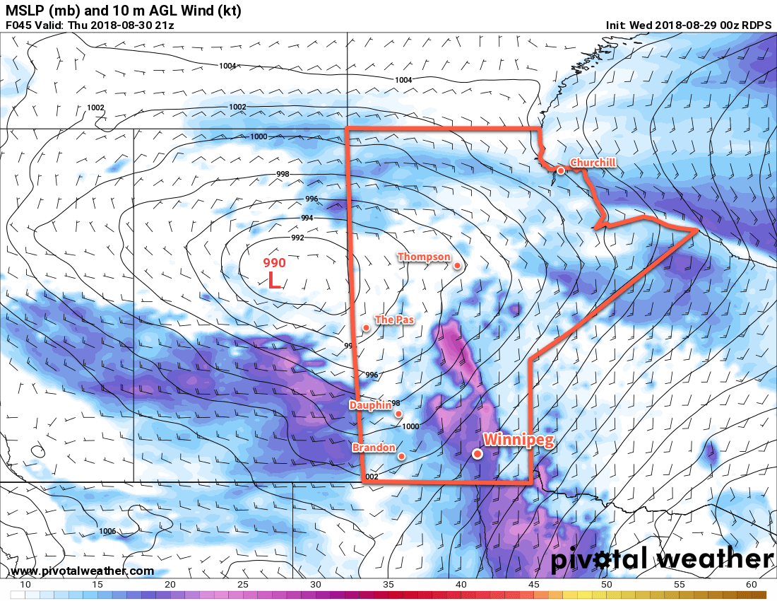
Hot on the heels of yesterday’s system, another low pressure system will bring a chance of rain to Winnipeg today. This disturbance, approaching from the west, will keep Winnipeg under mostly cloudy to mixed skies today. The city will see a chance of light showers through the morning hours, easing off near lunch. A few sunny breaks will likely develop in the afternoon, allowing temperatures to climb to a high near 25°C. The chance for showers or thunderstorms will then develop a bit later in the afternoon as the upper-level disturbance associated with this system moves through the region.

RDPS 12hr. QPF valid 12Z Saturday September 1, 2018
A few showers or thunderstorms are possible over the Red River Valley on Friday evening.

Winds will remain fairly light through the day, but northwesterly winds of 30 gusting 50 km/h will develop over southwestern Manitoba and my spread into the Red River Valley late in the day. Once the sun starts setting, winds will diminish as skies clear and temperatures head to a low near 10°C.

Pleasant Weather for the Weekend

The weekend will bring almost ideal weather for most. Saturday will bring mainly sunny skies to the region. Winds slowly increasing out of the south to 20-30 km/h as temperatures head to a high near 25°C again. A few clouds will begin working into the Red River Valley late in the day ahead of a frontal wave pushing across the southern Prairies.

On Saturday night, the southerly winds will turn northwesterly and diminish in the wake of a cold front that will move through. As it passes, it will bring a chance of some scattered shower activity to the Red River Valley. Temperatures will head to a low near 13°C with skies clearing some time after midnight.

Sunday will bring slightly cooler late-summer day. Winnipeg will see mainly sunny skies, a high near 22°C, and west-northwesterly winds of 30 gusting 50 km/h. The winds will ease later in the day, leaving the city with clear skies on Sunday night as temperatures drop to a low near 9°C.

Long Range Outlook

The beginning of next week looks quite nice with Monday bringing more sunshine and temperatures returning back towards the mid-20s. The remainder of the week is forecast to be cooler with daytime highs near 20°C as multiple disturbances bring variable cloudiness to the city. There appears to be a few chances for showers, but no widespread or major rain event looks likely at this point.

Winnipeg’s seasonal daytime high is currently 22°C while the seasonal overnight low is 9°C.


Warmer Weather Makes A Windy Return

Sunshine returns to Winnipeg today as warmer air beings moving back into the province. Conditions will be relatively pleasant – albeit windy on Thursday – with the only chance for rain expected overnight Thursday as a cold front moves through.

The upper trough which brought more cloud and showers to the province yesterday will move out of the region this morning, bringing an end to the showers as skies clear. Temperatures will remain slightly cool today, though, with Winnipeg’s high expected to reach 21°C. Winds will be light out of the west through the day. Skies should remain mostly clear tonight as the low dips to around 12°C with 20 to 30 km/h winds developing out of the south.

Thursday will bring warm temperatures back to Winnipeg as the high climbs to an above-seasonal 28°C. Unfortunately, the warmth will come with moderate southerly winds strengthening to 40 gusting 60 km/h. The Red River Valley will see a few clouds through the afternoon.

Moderate southerly winds will develop across the Red River Valley on Thursday afternoon

Heading into Thursday night, Winnipeg will see a slight chance of thunderstorms along a cold front moving through. It’s one of those situations where the best support for thunderstorms appears to be both north and south of Winnipeg, so we’ll just have to see if any manage to develop near us. If thunderstorms develop, there will be a slight risk of severe thunderstorms with the main threat of large hail and damaging winds.

Thursday Night Thunderstorm Potential

Going over the MIST ingredients:

  • Moisture: A strengthening southerly flow will develop over southern Manitoba on Wednesday night, sourced from the central Plains. This flow will result in significant moisture transport northwards, evidenced by surface dewpoints increasing from the high single digits on Wednesday night into the mid-teens on Thursday afternoon. Moisture should be rather deep given the general large-scale transport expected to occur.
  • Instability: Instability will be moderate with MLCAPE values of 1000-1500 J/kg expected to develop Thursday afternoon. The cold front will sustain the instabilities it pushes eastwards overnight with most models maintaining 1000-1500 J/kg of MUCAPE.
  • Shear: Moderate shear will be in place with 30-40 kt of effective shear. Profiles show favourable directional shear within the effective layer with south-southeasterly winds near the storm base veering to southwesterly aloft.
  • Trigger: The cold front pushing east-southeast should provide the focus for thunderstorm development.

These parameters favour strong to marginally severe thunderstorms that could persist along the cold front for much of the night. Due to the favourable shear profiles, discrete thunderstorms may develop early in the event lifecycle upscale growth transitions the storms into a multicellular line. Marginally severe hail of 2-3 cm appears possible with these thunderstorms, along with wind gusts of 80-100 km/h.

Behind the cold front, winds will diminish as skies clear and temperatures drop to a low near 13°C.

Friday will bring settled, pleasant weather to Winnipeg. The high should climb to around 23°C with west northwest winds of 20 to 30 km/h. Temperatures will dip to a cooler low near 10°C as a weak ridge of high pressure moves in overnight.

Long Range Outlook

Winnipeg’s weekend is looking fantastic with sunny to partly cloudy skies and temperatures in the mid-20s. Winds don’t appear that they’ll be much of an issue, either. All in all a great way to start September!

Winnipeg’s seasonal daytime high is currently 23°C while the seasonal overnight low is 10°C.

Hot, Hazy Weather On The Way Back To Southern Manitoba

Summertime temperatures are on the way back to Winnipeg, but they’ll be bringing more haze and smoke from the B.C. wildfires with them.

Winnipeg will see temperatures climb back above seasonal values today as a warm front approaches the region. Winnipeg should see a high near 29°C under sunny skies, but haze may move back into the region this afternoon. Winds will be out of the southwest near 20 km/h. Temperatures will head to a low near 16°C under clear skies tonight.

Thursday will bring more warm weather to Winnipeg with temperatures reaching a high near 30°C, likely with hazy conditions. Winds will be out of the south at 15 to 25 km/h. Skies will begin sunny, but a trough approaching from the north will bring increasing afternoon cloud. This trough will stall out near Winnipeg late Thursday, bringing a chance for some scattered showers or thunderstorms Thursday afternoon into the evening. Temperatures will dip to a low near 16°C once again.

Warmer-than-seasonal temperatures will once again spread across the southern Prairies for the latter half of the week.

Friday will see a low pressure system approach the province from the west. This low will keep much of southern Manitoba in a warm air mass, but the approach of this low will also likely bring thick smoke to portions of southern Manitoba. At this point it appears it will likely remain north of Winnipeg, spreading across WestMan and the Interlake. Winnipeg will probably see some hazy conditions, but the significant impact to air quality should remain further north for Friday. Temperatures will be warm again with a high in the upper 20s, perhaps creeping into the low 30s. Winds will continue out of the south-southeast at 15-25 km/h. Winnipeg should see just a few clouds. More cloud cover will begin working into the region overnight as temperatures dip to a low near 15°C.

Long Range Outlook

Thicker smoke will move through southern Manitoba this weekend as the low pressure system moves through and draws it southwards. A cold front passing on Saturday morning will likely usher in the worst – whatever exactly that ends up meaning – of the smoke. The weekend will bring cooler conditions with variable cloudiness, but rain still looks elusive.

There are some indications that we may move into a more unsettled pattern to start next week that could bring some much-needed rain to the region, but for now we’ll just have to wait and see how things pan out.

Winnipeg’s seasonal daytime high is currently 24°C while the seasonal overnight low is 11°C.

Hot And Hazy Start to the Weekend, Cool End

An approaching low pressure system will bring hot and hazy weather to Winnipeg before a cold front passing Saturday brings a risk of thunderstorms and ushers cooler conditions back into the region.

Winnipeg will continue to see hazy skies today as the over 500 fires that have led to a state of emergency in British Columbia continue to send plumes of some eastwards into the Prairies. The thickest smoke has left the region and winds aloft should keep the main smoke track further north across the central and northern Prairies. Plenty of haze and stagnant high-level smoke will remain in the area with some limited visibility restrictions.1 The significant thinning of the smoke will let the sun shine much more strongly and send daytime highs in the region up into the low 30s. Winds will be out of the south at just 10 to 15 km/h.

Winds will increase out of the south to around 20 km/h tonight as temperatures dip to a low near 15°C under mixed skies.

Saturday should be a scorcher of a day…assuming the smoke can stay away. If we see the sun, then temperatures will soar to a high near 33°C with winds out of the south-southwest at 30 gusting to 50 km/h. Winnipeg will see partly skies in the morning, then a bit more cloud in the afternoon. Some forecasts show some elevated convection developing on Friday night and spreading across portions of western Manitoba and the Interlake. If that does form, it will likely remain north of Winnipeg but will bring some cloud and chances for showers to portions of the province through the morning hours.

A low pressure system crossing the Prairies will likely bring unseasonably warm conditions to the region on Saturday

A cold front will push through the Red River Valley late in the afternoon and through Saturday evening, bringing with it the chance for some showers or thunderstorms. At this point, there looks to be minimal chances for severe weather with under 1000 J/kg of MLCAPE forecast and bulk shear values near 20 kt.

The potential pitfall for Saturday’s forecast will be if thicker smoke once again moves into the region. It’s hard to tell at this point whether or not it will. Most guidance suggests it will primarily remain further north, but cold fronts can concentrate smoke ahead of them, so we’ll simply have to wait and see. If thicker smoke ends up returning, temperatures will be cooler and the chances for showers or thunderstorms diminish.

For Saturday night, Winnipeg will see winds diminish and temperatures head to a low near 16°C with a slight chance of showers continuing overnight.

Sunday will bring mostly cloudy skies to the region as an upper trough swings through. A small chance for showers is likely to continue into the morning, followed by clearing skies through the afternoon. Temperatures will be much cooler with a high near 23 or 24°C as northerly winds of 30 gusting 50 km/h move into the region. Temperatures will head to a low near 12°C on Sunday night under clear skies.

Long Range Outlook

Southern Manitoba will be under a northwesterly flow through the first half of next week which should bring clearer skies and near-seasonal temperatures. An upper-level ridge will push eastwards mid-week, bringing warmer weather back to the region alongside the potential for more smoke.

Winnipeg’s seasonal daytime high is currently 25°C while the seasonal overnight low is 12°C.

  1. Many places in the air mass we’ll find ourselves in today saw visibilities of 8 to 16 km through the day yesterday.