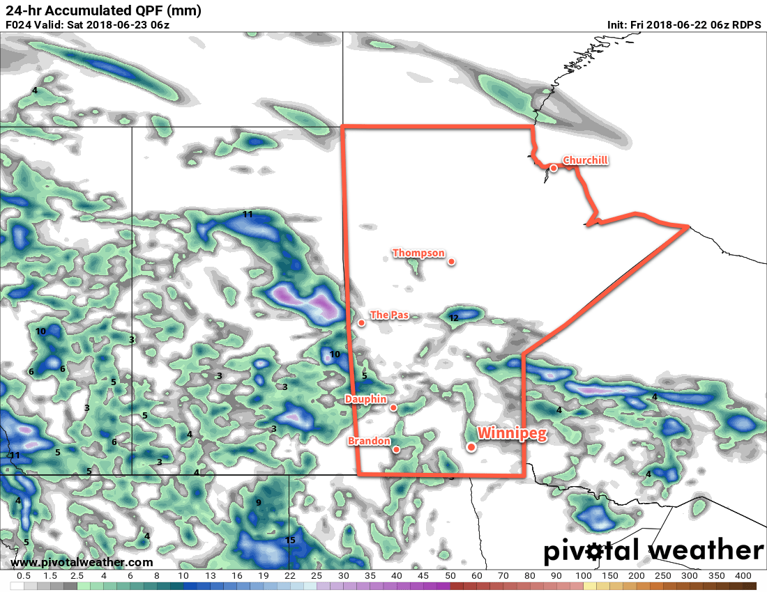
A disturbance crossing the Prairies will bring generally unsettled conditions with scattered showers and thunderstorms to southern Manitoba to round out the week.
Mixed to mostly cloudy skies will move into Winnipeg and the Red River Valley today ahead of an upper-level disturbance slowly moving eastwards through Saskatchewan. Over the next two days, unsettled conditions will produce scattered showers and thundershowers across the region. Slack winds over the region mean that the [thunder]showers will be fairly slow-moving, with local rainfall amounts of 5 to 15 mm possible. Conditions will settle for Sunday, with more sunshine building into the region under partly cloudy skies.
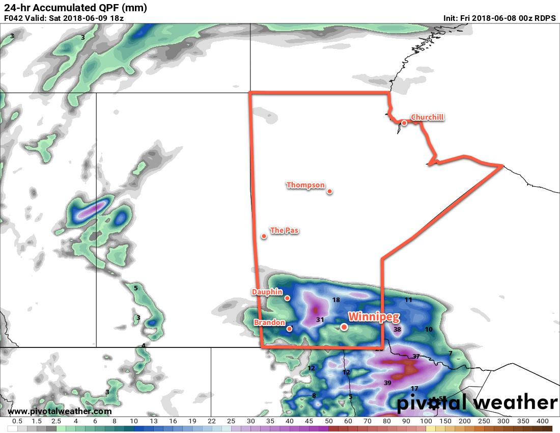
Forecast 24 hour accumulated precipitation shows shows the widespread likelihood for showers across much of southern Manitoba today.
Temperatures will continue to be warm with highs in the upper twenties or low thirties. Lows in the 16 to 18°C range are forecast for the next few days.
Long Range Outlook
Next week will kick off with unsettled conditions as a southerly flow redevelops and taps into warmer, more humid air. Highs will climb back towards 30°C with muggier conditions moving into the region.
Winnipeg’s seasonal daytime high is currently 24°C while the seasonal overnight low is 12°C.
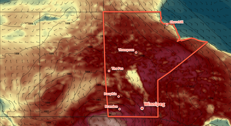
A potent low pressure system developing in Alberta today will bring southerly winds to the Red River Valley that will bring heat and humidity back into the region.
Today will be a beautiful day in Winnipeg. Morning sun will give way to some afternoon cloud as temperatures head towards a high near 26°C. Humidity will be low today, and winds will continue out of the southwest at around 20 km/h. Skies should clear out in the evening, then a relatively mild night is forecast with a low in Winnipeg near 16°C. After midnight there will be a slight chance of a shower or thunderstorm as a warm front lifts through North Dakota.
Thursday will bring mixed skies to Winnipeg with southeasterly winds increasing to 30 to 40 km/h. Temperatures will climb to a high near 28°C with humidity gradually increasing through the day. Attention then turns to southeastern Saskatchewan and southwestern Manitoba. By mid- to late Thursday afternoon, the potential for a severe thunderstorm outbreak exists. All of the ingredients are there for potent storms, however whether or not the storms develop as forecast will depend significantly on the region seeing enough sunshine and heating through the day.
Thunderstorms, potentially severe, will likely be moving into western Manitoba on Thursday evening.
If all goes as currently forecast, then thunderstorms would develop and move onto western and southwestern Manitoba in the evening. Depending on how the thunderstorms evolve, the risk for severe thunderstorms with large hail and damaging winds may develop in the Red River Valley overnight. There is the chance that it misses the region, though. Some models suggest the best dynamics lift north of the region and the greatest energy collapses south. For now, know that there’s a chance of thunderstorms Thursday night, with a slight risk they’ll be severe.
Otherwise, Thursday night will a warm one with southerly winds of 15-25 km/h and a low near 19°C.
Friday will bring clearing skies to Winnipeg as a cold front sweeps through the region. It will still be warm with a high near 28°C, but the humidity should drop off markedly with the passage of the front. Winds will shift out of the west midday at around 20 to 30 km/h Winnipeg should see a few clouds on Friday night with a low near 14°C and calm winds.
Long Range Outlook
The weekend will likely bring a fair amount of cloud cover to Winnipeg as a significant storm system moves through the northern United States. At this point it looks like most of the precipitation will remain south of the border, but the Red River Valley may see some rain on Sunday afternoon into the evening. Temperatures will return to seasonal with highs of 23 or 24°C forecast for both Saturday and Sunday.
Winnipeg’s seasonal daytime high is currently 23°C while the seasonal overnight low is 11°C.
Cloudy skies with a chance of showers or thunderstorms will mark the transition into warmer weather that will arrive in Winnipeg on Sunday.
Winnipeg will see mixed to cloudy today as another disturbance tracks towards Manitoba. A chance of showers or thunderstorms will develop late in the morning for a few hours as a band of instability moves through the region. Once that moves through, temperatures will continue to a high near 25°C with some sunshine poking out for the afternoon. Winds won’t be too bad, either. Beginning light in the morning, winds in Winnipeg will pick up into the 20 to 30 km/h range out of the southeast for the afternoon.
Skies will cloud up again on Friday evening with a chance for showers or thunderstorms redeveloping overnight. The persistent southeasterlies will begin drawing more humid air into Manitoba tonight, raising dew point values into the mid-teens. Winnipeg should see a low near 16°C.
Any remaining showers should clear out early Saturday, leaving Winnipeg with mostly cloudy skies and just a very small chance of an isolated shower. Temperatures will be near-seasonal in Winnipeg with a high near 23°C. Winds will continue out fo the southeast, but only at 10 to 20 km/h. The cloud cover will begin to break up Saturday night as temperatures drop to a low near 17°C.
While Winnipeg will see a couple chances for showers/thunderstorms Friday into Saturday, there’s always that chance it dances around the city…
Sunday will be a scorcher in Winnipeg with the clouds giving way to mixed skies and temperatures soaring to a high near 30°C. Winds will be windy out of the southeast at 30 to 40 km/h, though, which will make spending time outside a little less pleasant.
Sunday night will bring more cloud back into the Red River Valley as a cold front pushes eastwards into the province. While western Manitoba will almost certainly see a high chance for thunderstorms, it’s less certain in Winnipeg and other areas further east. It will depend on how quickly the front moves east, which in turn depends on how much and what sort of thunderstorm activity develops. That said, Winnipeg will see increasing chances for thunderstorms overnight Sunday into Monday morning. Temperatures will dip to a low near 18°C.
Long Range Outlook
Once the cold front passes on Monday, it looks like Winnipeg will remain in a much cooler pattern. Daytime highs look to move to seasonal to seasonably cool values with highs in the low 20’s for the remainder of next week. Winnipeg will see variable cloudiness and generally dry conditions.
Winnipeg’s seasonal daytime high is currently 23°C while the seasonal overnight low is 10°C.
Warmer temperatures are on the way back to Winnipeg, but will come with variable cloudiness and the potential for more shower and thunderstorm activity.
Today will bring sunny skies and cool temperatures to Winnipeg as a ridge of high pressure moves through the region. As the ridge moves in, northwesterly winds near 30 km/h this morning will taper off to light in the afternoon. Winnipeg should see a high temperature near 21°C. Temperatures will dip to a low near 11°C under clear skies tonight.
Thursday will see the heat begin to build back into Manitoba as southerly winds of 20 to 30 km/h draw warmer air northwards. An upper-level disturbance will spread showers and thunderstorms through North Dakota, and while Manitoba should escape most of the precipitation, many areas will see mixed skies or cloudy periods. Winnipeg will likely end up with mixed skies as temperatures head to a high near 26°C. Winds will diminish Thursday evening as temperatures dip to a low near 13°C under mixed skies.
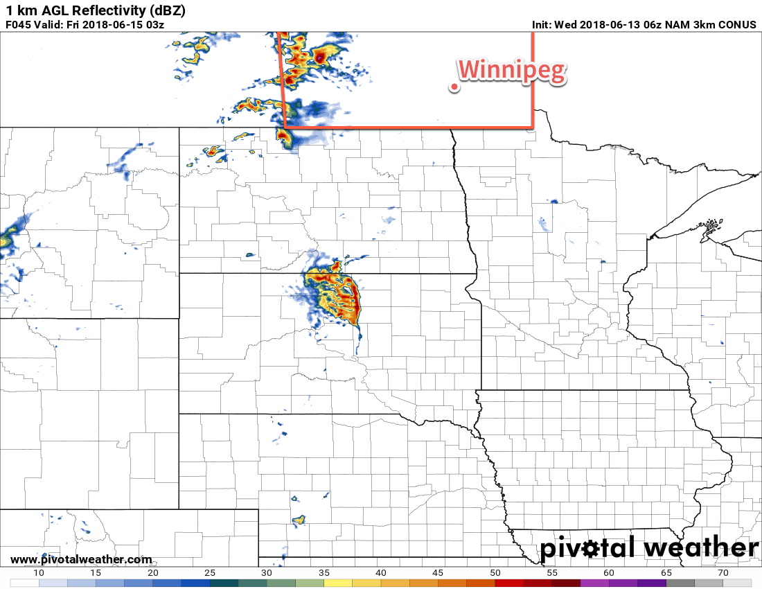
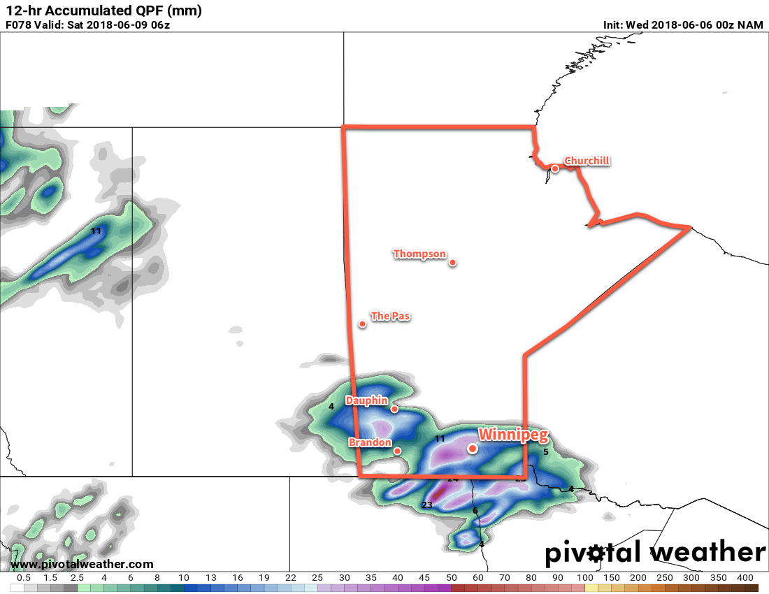
Several models, including the NAM pictured above, show an area of showers and thunderstorms moving through southern Manitoba on Friday
On Friday, a low pressure system sliding eastwards along the international border will bring cloudy skies and along with a good chance of showers or thunderstorms to the Red River Valley. The cloud cover will keep things cooler with Winnipeg likely seeing a high near 23°C. Skies will begin to clear overnight as the low moves off to the east. Winnipeg will see a low near 15°C on Friday night.
Long Range Outlook
Heading into the weekend, conditions look great with plenty of sunshine and daytime highs in the upper 20s. Humidity should remain low, making for comfortable days. Winds will be a bit breezy on Sunday out of the southeast, picking up ahead of the next low moving towards the region.
At this point, Monday looks to bring a return to unsettled conditions with the chance for showers and thunderstorms. This will clear up rather quickly, returning to variable cloudiness and seasonal temperatures into mid-week.
Winnipeg’s seasonal daytime high is currently 23°C while the seasonal overnight low is 10°C.