This Week May Start with a Bang

There will be a risk of strong to severe thunderstorms in Southern Manitoba to start the week – hence why it may start with a bang!
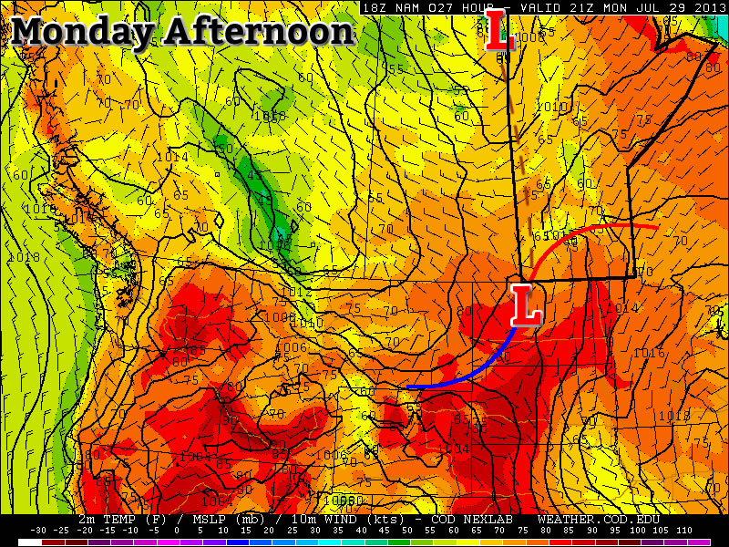
Positions of Fronts on Monday Afternoon

Monday

Monday

Mix of Sun and Cloud. Risk of a Thundestorm.
25°C / 12°C

Today’s weather will be dominated by a risk of thunderstorms in Southern Manitoba. These storms may become severe, with large hail, damaging winds, and heavy rain. Tornadoes will be possible, but the risk is quite low. The reason why thunderstorms are being forecast for today is due to an unstable atmosphere being in place over Southern Manitoba along with a jet stream overhead. When combined, these ingredients can produce strong storms. If you’re in the mood for a more details, please read the technical discussion below.

Technical Discussion:

There is a slight risk of severe thunderstorms in Southern Manitoba today. An overview is offered below:

Moisture: Surface dewpoints in the mid to upper teens will be in place over Southern Manitoba by this evening. At 850mb, dewpoints will be around 10C.

Instability: MLCAPEs of 1000-2000J/kg will be in place over the western half of Southern Manitoba this evening. This instability will likely be transported eastward through the rest of Southern Manitoba during the late evening to overnight period.

Wind Shear: 0-6km bulk shear is currently 25-30kts over Southern Manitoba. An upper-level jet at 250mb is in place along the International border, with speeds of around 70kts. In the low-levels a south to south-westerly low-level jet of 20-30kts will be in place this afternoon.

Trigger: A trough will be positioned through the western-most portions of Southern Manitoba today. In addition, models suggest a weak surface low may be located near Portage la Prairie by late evening. A pseudo-warm front will likely extend from this surface low north and eastward through Southern Manitoba during the day. In addition, the left exit of a 250mb upper-level jet will be position over Southern Manitoba during the day today.

Monday’s Thunderstorm Risk Map

Conclusion: There will be a risk of severe thunderstorms today through much of Southern Manitoba. This risk is contingent on sufficient daytime heating, with convective temperatures generally being in the mid-twenties. Should sufficient heating occur, storms should develop along the trough and possibly surface low during this afternoon. Storms will drift east and persist into the evening. Models suggest there will be some useable elevated instability tonight, so storms may persist after dark. However, the timing of storm evolution will be important, since the atmosphere does not destabilize in the Red River Valley, and points east, in a significant fashion until around/after dark. Thus, if storms move eastward too quickly, they may not be in phase with the plume of instability. Therefore storms may begin to weaken by late evening if the aforementioned factors are not in sync. Storms are generally expected to be multicellular in nature, however some supercells will be possible, particularly during the evening hours in south-central Manitoba.

Tuesday

Tuesday

Mix of Sun and Cloud. Slight risk of a Thunderstorm.
24°C / 10°C

The forecast for Tuesday is a somewhat tricky one. A cold front is forecast to lie somewhere near or in Southern Manitoba during the day on Tuesday. Depending on the character of this front, Tuesday may be a mostly cloudy and increasingly cool day, or it could be a rather nice day. At this point it appears most probably that Tuesday morning into the afternoon will be fairly nice, with temperatures in the mid twenties. However, at some point in the afternoon or evening rain and/or thunderstorms may move in, cooling things down and bringing an end to the nice day. There is still a fair bit of uncertainty with the Tuesday forecast, so we’ll update you again as necessary

Wednesday

Wednesday

Mix of Sun and Cloud
23°C / 8°C

Wednesday looks to be a decent day in Southern Manitoba. High temperatures are expected to be in the low to mid twenties with a breezy north-west wind of 20-30km/h gusting to 40-50km/h. Skies will be a mix of sun and cloud due to fair weather cumulus development throughout the day.

Showery Weather Ahead

A persistant Arctic vortex over the Eastern Arctic will continue reinforcing a westerly to northwesterly flow over the Prairies which has been bringing cooler summer weather to Southern Manitoba. Multiple disturbances are forecast to track down in the northwesterly flow which will produce a showery second half to the week.

Wednesday

22°C / 13°C
Increasing cloudiness then showers with a risk of a thunderstorm in the afternoon.
Thursday

21°C / 11°C
Cloudy with scattered showers. Windy.
Friday

22°C / 10°C
Mainly sunny.

We’ll see a fairly cloudy day today as temperatures climb to only around 22°C. A trough of low pressure will work it’s way into and through the Red River Valley bringing scattered showers with the risk of a thunderstorm through much of the day and the early evening. No severe weather is expected. Skies should clear overnight as we drop to a low of around 13°C.

On Thursday a second – more potent – system will begin working it’s way through the province. Clouds will roll in early on Thursday as an upper disturbance tracks an area of rain through the Interlake. Here in the Red River Valley we’ll likely see another round of scattered showers starting midday with the winds picking up out of the north to around 30km/h with gusts to 50 or 60km/h. Thunderstorms aren’t expected and we’ll see a high near 21°C. Things will clear out overnight as we head to a low of about 11°C.

Friday will bring more stable weather with mainly sunny skies and a high of 22°C. Winds will continue to be breezy through the morning but should begin to let up in the afternoon. Things look very pleasant through the weekend with mainly sunny skies and highs in the mid–20’s with overnight lows in the 12–13°C range.

Mixed, Mild Weather Ahead

A northwesterly flow building over the province will bring mild temperatures and bouts of unsettled weather with little in the way of severe storm threats, making for a fairly pleasant week overall.

Monday

21°C / 12°C
Mostly cloudy; clearing late in the day.
Tuesday

24°C / 13°C
Mainly sunny. Slight chance of showers or thunderstorms in the evening.
Wednesday

24°C / 12°C
Cloudy periods. Chance of showers in the evening.

Today will be marked by relatively cloudy skies with a breezy northwesterly wind as the low pressure system that brought severe thunderstorms to Southern Manitoba yesterday slowly moves out of the province. This has ushered in cooler air once again which will keep our temperatures fairly cool for the next few days – we’re expecting daytime highs to only climb into the low-to-mid 20’s and overnight lows to sit near the 12–13°C mark.

Tuesday will be a pleasant day with mainly sunny skies and a high near 24°C and while there’s a chance of a shower or thunderstorm on Tuesday evening, it really is an outside chance and much more likely to happen over SW Manitoba than over the Red River Valley.

500mb upper trough approaching Manitoba from the Northern Prairies on Wednesday evening (from the GFS).

500mb upper trough approaching Manitoba from the Northern Prairies on Wednesday evening (from the GFS).

On Wednesday we’ll see a chance of showers later in the day under a mixed sky as a long-wave trough rotates towards Southern Manitoba from the Northern Prairies. At this point it doesn’t look too energetic and there’s little in the way of thunderstorms expected. We’ll se a high near 22°C and a low once agin in the 12–13°C range.

Rainy — And Potentially Stormy — Thursday Ahead

Sunny skies will turn rather unsettled on Thursday as multiple disturbances move across Southern Manitoba.

Wednesday

Wednesday

28°C
Mainly sunny. Chance of showers near the U.S. border.
Wednesday Night

15°C
Increasing cloud. Showers beginning overnight with the risk of a thunderstorm.

We’ll see mainly sunny skies today as we spend a short amount of time in the stable air behind the cold front that passed through yesterday. That front will be sitting south of the border in North Dakota, however a very strong upper-level jet will be in place through Northern North Dakota near the Canadian border. There will be a slight chance of showers near the border thanks to the extra lift supplied by this feature.

We’ll see increasing cloudiness tonight as the upper-level jet starts pushing back northwards and the aforementioned cold front becomes a warm front and start pushing northwards again. Showers – with the risk of a thunderstorm – will develop over SW Manitoba overnight and advect eastwards into the Red River Valley before morning. No severe weather is expected.

Thursday

Thursday

24°C
Showers ending midday then cloudy with a few sunny breaks and a continued chance of showers.
Thursday Night

15°C
Showers with the risk of a thunderstorm overnight.

Thursday morning will start off rainy with the risk of a thunderstorm. Around 10–20mm of rain is possible however any higher amounts will likely be localized to any heavier patches of rain that develop. Things should taper off by midday leaving us with cloudy skies and perhaps a sunny break or two, but a chance of showers will continue through the afternoon.

Thursday night will start off cloudy then rain will push in by the late evening period as another cold front sweeps southwards from the central Prairies. Unfortunately, this area of rain will likely start off as thunderstorms over SW Manitoba.

NAM sounding valid on Thursday evening near Brandon, Manitoba.

NAM sounding valid on Thursday evening near Brandon, Manitoba.

Quickly looking at some of the convective elements in place:

  • MLCAPE values forecast to be in excess of 2000J/kg
  • 60kt 500mb jet will begin work it’s way into the region with the left exit of the jet poking into the Melita & Virden regions early in the evening.
  • A frontal boundary will be very close to the area providing convergence that can act as a trigger for storm initiation.
  • Falling heights through the upper atmosphere should help prime things for both initiation convection and to sustain anything that does manage to get going.

Low-level shear will not be favourable for the development of tornadoes, but the strong straight-line shear combined with ample moisture and relative low freezing levels will make large hail and torrential downpours a serious concern. Given the shear profile and the strength of the winds aloft, there may be a slight chance that these storms will develop strong straight-line winds. The main threat for severe weather will be over southwest and western Manitoba; at this point it looks like points from Virden to Minnedosa east to the lake then down along the shore-line to Portage face the biggest threat for severe weather, although not much would have to change to include Melita & Pilot Mound regions in there too. We’ll take a look at things a little later today and update this post with a severe thunderstorm outlook graphic if it seems applicable.

The thunderstorms will grow into an area of rain as they travel eastwards towards the Red River Valley. Here in Winnipeg we’ll still see the threat of a thunderstorm overnight, but it should mainly be rain – potentially heavy at times – amounting to about 5–10mm. If we see a thunderstorm than naturally the accumulations could be significantly more than that. The storms and rain should move out of the RRV into Northwestern Ontario overnight.

Friday

Friday

24°C / 15°C
Mainly sunny.

Mainly sunny skies will dominate on Friday as we move into a cooler, stable air mass in behind Thursday’s system. We’ll see the cooler weather persist for another day or so before hot weather begins working it’s way back into the area with temperatures looking to climb back towards 30°C on Sunday. The weekend looks gorgeous so get out there and enjoy it!