Southern Manitoba 2014 Thunderstorm Statistics

This photo of a funnel cloud was taken just southwest of Winnipeg.

Welcome to our summary of the 2014 thunderstorm season across Southern Manitoba! This post will summarize these statistics and compare this year’s thunderstorm season to the last couple seasons. In case you are curious, a brief explanation of how I gathered these statistics can be obtained by following this link.

Thunderstorm Days

The number of days with thunderstorms across southern Manitoba broken down into 6 regions. Includes the date of first thunderstorms and last thunderstorms.

In total, there were 94 thunderstorm days across southern Manitoba in 2014 (southern Manitoba being defined as the area shaded in the map above). This was slightly higher than in 2013 (89 thunderstorm days) but still much lower than in 2012 (~ 109 thunderstorm days). This is mainly the result of a late spring and thus, a late start to the season in both 2013 and 2014. 2012 featured an early spring with numerous thunderstorm events in March and April. This year, no thunderstorms occurred in March and only 2 thunderstorm days occurred in April. In fact, southeastern, eastern and Interlake portions of southern Manitoba did not see their first thunderstorm until the third or fourth week of May, at least a month later than usual. Winnipeg didn’t get its first thunderstorm until May 20, the 8th latest first thunderstorm on record since 1953.

The distribution of thunderstorm days, as seen in the map above, was fairly uniform across southern Manitoba overall. Similarly to 2012 and 2013, the region east of Lake Winnipeg saw notably less thunderstorm activity.

Interestingly, there was a thundersnow event in January! Although lightning detection products did not record the lightning, lightning was reported by residents west and southwest of Winnipeg on the evening of January 15; more specifically between Carman and Winkler. This was associated with a very strong cold front behind a potent Alberta Clipper. This clipper also brought record winds and high temperatures across the Prairies. Unfortunately, I could not find any data on winter thunderstorm activity in Manitoba historically. The only other occurrence of lightning in January I could find was a report in the Daily Free Press of lightning on January 16, 1876 (Penziwol, 2004). This is not to say that lightning has never occurred in January since then, but that is the only other report I could find. Nonetheless, this year’s thundersnow event was extremely rare for Manitoba.

In Winnipeg, 23 thunderstorm days occurred at the airport in 2014. Although this is the most since 2010, it is still below the normal of ~26–27 thunderstorm days. In fact, we have not had an above normal season since 2007. The last thunderstorm recorded was on September 8, tying for 10th earliest last thunderstorm since 1953. This puts the season at 112 days long, the 5th shortest on record. However, this statistic is a bit misleading. Thunderstorms did occur in southern parts of the city 3 times after September 8, including 2 events in October. I recorded 27 thunderstorm days here in South St Vital this year and the season lasted 156 days.

Severe Thunderstorm Warning Days

The number of days in which severe thunderstorm warnings were issued through 2014 in Manitoba, broken down by forecast region.

In total, there were 34 days with a severe thunderstorm warning issued in southern Manitoba. This is similar to 2012 but much less than in 2013 (45 severe thunderstorm warning days). The first warning was issued on May 24 and the last on September 8, putting the season at 108 days long. This is a tad less than in 2013 (110 days long) and 2012. As has been the case the last few years, southwestern Manitoba saw the most severe thunderstorm warning days in 2014.

Tornadoes

The number of days tornado warnings were issued across Manitoba in 2014, broken down by forecast region.

There were 4 tornado warning days in 2014, half the number in 2013 (8 days) but double the number in 2012 (2 days). The Red River Valley area saw the most. In fact, the warning zone southeast of Winnipeg, which Steinbach is situated in, saw 3 tornado warning days, the highest of all warning zones in Canada this year. However, only one of these warnings actually produced a confirmed tornado (an EF–0 southeast of La Salle on July 26).

From what I could find, 4 EF–0 tornadoes were confirmed in Manitoba this year. However, it is likely that there were more (many go unconfirmed). July 26 was the biggest tornado day of the year with 3 landspout tornadoes confirmed (all EF–0). 2 were in the Interlake near Waterhen and the other was southeast of La Salle.

A tornado might have touched down (unconfirmed) southwest of Winnipeg July 5. Part of the A Weather Moment team (Scott, Matt, Julien & Kyle) watched the storm as it evolved and managed to capture at least 2 funnel clouds. One of these is seen in Matt’s funnel cloud picture at the top of this post. After reporting this funnel to Environment Canada, a tornado warning was issued for the City of Winnipeg.

Monthly Frequency

Thunderstorm-related days per month (thunderstorms, severe thunderstorms and tornadoes) for Southern Manitoba in 2014.

For the first time since I started gathering these statistics in 2010, the busiest month of the year for thunderstorm activity across southern Manitoba was in June. The maximum is typically in July, but this year there was an unusual local minimum in activity in July with just 18 thunderstorm days. Residents in southwestern Manitoba were especially hard hit in June with multiple rounds of heavy thunderstorms and rains mid-late month. Over 150 mm of rain fell in the heaviest hit areas in just a period of 2 weeks. 251.6 mm of rain fell in June in Brandon, the rainiest June on record since 1890. 219.8mm of this fell in just the last 12 days of the month. Extensive overland and river flooding occurred as a result, as many of you likely still remember well.

If interested in comparing, follow these links for the 2013 and 2012 graphs: 2013, 2012.

Reference Cited
  1. Penziwol, Shelley. (2004). Storm Signals: A History of Weather In Manitoba. Great Plains Publications. Winnipeg, Manitoba. Page 3.
Elsewhere in Weather News: December 21st, 2013

Southern Ontario, Midsection of US Anticipate Ice Storm

A major ice storm has been taking shape as of Friday night across parts of Oklahoma and Texas and will continue to push northeast. A potent cold front with Arctic air filtering in behind it is clashing with gulf moisture moving north and thereby creating prime conditions for ice accumulation from Oklahoma all the way to southern Ontario. Dangerous travel conditions are expected as there could be significant ice accumulation due prolonged periods of freezing rain through this weekend. With this comes the possibility of downed power lines so residents have been made aware to prepare for power outages across southern Ontario. So overall, not ideal conditions for holiday travel this weekend as all kinds of precipitation will be falling across the eastern half of the US and southern Ontario.


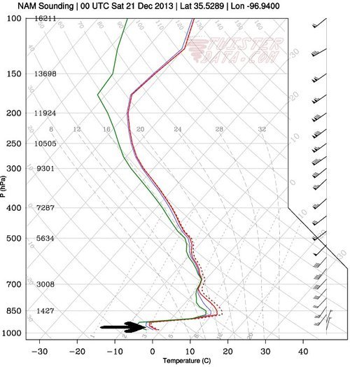
Freezing rain sounding from Oklahoma on Friday evening. Note the shallow freezing layer near the surface where the arrow is. (Souce: Twisterdata)

Freezing rain forms when there is a deep layer of warm air that is above freezing aloft. As the ice crystals fall and meet the warm layer, they melt and become raindrops while falling towards the ground. A shallow layer of cold air just above the surface of the earth must also be present for freezing rain to form. Supercooled water droplets – drops of liquid water that exist in below freezing air, will be in place and won’t have enough time to freeze into ice pellets, thus will freeze (as ice) on contact as they hit the ground.

In addition to this, a severe weather outbreak is expected in Dixie Alley of the US today. The outbreak is associated with the same system as the cold front slices through the warm, moist air mass in place. A moderate risk has been issued by the Storm Prediction Center as well as a 15% hatched area for tornadoes in Mississippi and northern Louisiana. Chances of tornadoes are quite high, the only possible limiting factor is that CAPE will be fairly low (only around 500-1000J/kg) but this will still be sufficient for supercells which will quickly evolve into a quasi-linear convective system – a line of severe thunderstorms that can have bowing segments. SPC gives fairly strong wording for today in Dixie Alley saying that “there is potential for several tornadoes – some of which should be strong”.

By Monday night the system will have moved off the US East Coast but will still be a weather-maker for Atlantic Canada.

Elsewhere in Weather News: November 29th, 2013

Flooding Affects Italy

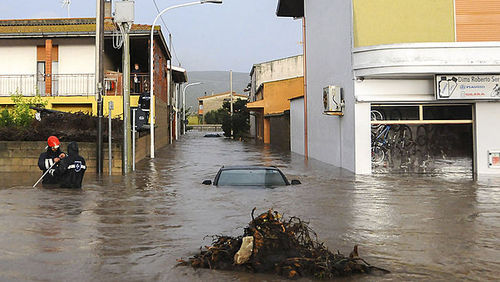
Severe flooding has been taking place in Sardinia, Italy this past week causing residents to rush for higher ground. Sardinia is one of Italy’s islands located in the Mediterranean Sea; about 1.7 million Italians reside here. An upper level low drew in moist air from the Mediterranean Sea and spun just off the coast of Sardinia, causing for some significant flooding on the island. Rainfall totals generally ranged between 35 and 50mm on the island, which is over half of their monthly total for November.


Severe flooding in the city of Uras, on the island of Sardinia. (Source: AP)

As this fell in a span of about 24 hours, sewers were unable to handle these large volumes of water in that short period of time. In some areas water levels reached about three meters, causing roads and bridges to be washed away. As of Friday night 18 fatalities had been reported. Several waterspouts and brief tornadoes had also been spawned by this system off of Italy’s coast and on the mainland.

Tornadoes Rip through US Midwest

In last week’s post of EIWN the risk for severe storms affecting the Midwest US had been briefly talked about. The event that occurred on Sunday was a fairly significant event; the moderate risk talked about in last week’s post had been upgraded to a high risk on Sunday – a risk only issued once or twice by the SPC when major severe weather events are imminent. This severe weather event followed up with all the hype ahead of it. In total, 106 tornado reports were received and 74 tornadoes were confirmed. Two of these were classified as EF-4 strength and 33 classified of EF-2 strength and higher, making November 17th a significant tornado outbreak in the Midwest. There were also numerous (400+) wind damage reports scattered from Iowa to New Jersey, as expected with the high shear environment on that day. One of the strongest tornadoes of the day – an EF-4 ripped through the town of Washington, Ill., where some houses were completely ripped apart by the twister. Death toll from the outbreak is at eight but could have been significantly higher if not for the good forecasting and swift warning issuance by NWS.


Map of all the warnings and watches issued on the 17th. Tornado watches/warnings in red and severe thunderstorm watches/warnings in blue. Polygons are the warnings. (Source: SPC)
Map of all the warnings and watches issued on the 17th. Tornado watches/warnings in red and severe thunderstorm watches/warnings in blue. Polygons are the warnings. Click on image to enlarge. (Source: SPC)

Elsewhere in Weather News: October 5th, 2013

Quadruple threat in the US this Week

All kinds of extreme weather have been plaguing the United States this week; from tropical storms, tornadoes to blizzards to severe Santa Ana winds, they’ve just about seen it all. It was all happening yesterday due to a dynamic low pressure system centered in the Northern US Plains. High pressure building behind the low pressure system was responsible for the Santa Ana winds. The tropical storm, a completely separate system, has been targeting the gulf shores for a few days now.

The powerful fall low pressure system was drawing in brisk air from the north behind it which helped produce ideal conditions for blizzard conditions in the Black Hills. It was not unusual to see snowfall rates in excess of 5cm/h throughout the day on Friday in the region. The hardest hit area in regards to snow looked to be Lead, SD, which by Friday night had received 110cm (in less than 48 hours!), and another 20-30cm could fall before deformation zone moves off.

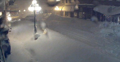
Lead, SD snow

Streetcam picture of the snow accumulated in Lead, SD. Keep in mind there was no snow on the ground less than 48 hours ago! (Source: Twitter: @TylerJRoney)

Deadwood, SD snow drifts

Incredible image of a large snow drift almost completely covering the front door in Deadwood, SD. (Source: Twitter: @ReadingReineke)

In the warm sector of the same system severe thunderstorms were spawned on Friday. A few supercells formed in the late afternoon near the triple point in northern Nebraska/extreme southern South Dakota. With extremely favourable conditions for tornadoes, storms quickly started rotating. The number of tornadoes is still unclear at this time but a violent, long tracked, wedge tornado which was reported to be over a mile wide, touched down. Per initial reports it appears as though Wayne, NE was the hardest hit on Friday by this tornado. Houses and factories were completely demolished and two dozen people were reported injured. A squall line also evolved further south into Kansas and Oklahoma where large hail and severe wind were the main threats.

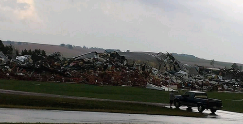
Wayne, NE damage

Damage of a factory destroyed in Wayne, NE from the tornado that hit the town. (Source: Twitter: @action3news)

The Santa Ana winds have been a treat to California this week, too. These winds get funneled through the Mountains of Southern California, subsequently warm and dry as they descend in elevation. Gusts in excess of 110km/h have been tearing through Southern California bringing with them an extreme fire risk. This prompted the National Weather Service (NWS) to issue multiple red flag warnings for the area – these warnings are issued when conditions are ideal for wildfires and quick intensification. The NWS also added that these were the worst winds in five years.

As for the tropical storm (Karen) spinning in the Gulf of Mexico, it does not appear that it will become a significant hurricane. Strong wind shear has been affecting its development for the past few days. It will likely make landfall as a tropical storm with winds of tropical storm force, but possibly even weaker depending on how much the shear tears the storm apart. The location of the landfall looks to be on the south-east gulf shores of Louisiana. It doesn’t appear as though its effects will be too significant to the US – heavy rain will be the main threat with Karen. Otherwise, the tropics continue to remain unusually calm and no other developments elsewhere in the Atlantic basin are expected in the near future.