Severe Thunderstorms Ravage Saskatchewan and Manitoba

A line of severe thunderstorms tore across southeastern Saskatchewan and southwestern Manitoba yesterday producing widespread damage due to rain, hail, and what is increasingly likely a tornado.
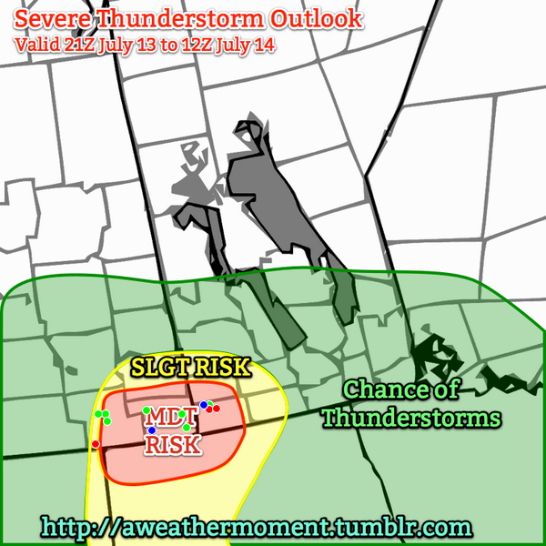
A verification of the AWM Severe Thunderstorm Outlook issued on Saturday morning. Green dots: Severe Hail Reports. Blue dots: severe wind reports. Red dots: tornado reports.

A potent severe weather setup was in place yesterday as a trough of low pressure began to move it’s way from Alberta into the hot, humid air that was pushing into SE Saskatchewan. Ample moisture, heat, instability and wind shear was in place for the development of severe thunderstorms and – given the strongly veering wind profile – the likely development of tornadic supercells. With this in mind, we issued our morning severe weather outlook with a moderate risk for severe thunderstorms in the Estevan, Carlyle, Moosomin, Virden & Melita forecast regions, with a slight risk extending further eastwards into the Pilot Mound & Brandon regions.

Saskatchewan Pounded By Large Hail

Supercell thunderstorm developing just SW of Weyburn, SK at 1900Z.

Supercell thunderstorm developing just SW of Weyburn, SK at 1900Z.

Storms developed earlier than expected; by 1900Z there was a supercell taking shape not too far SW of Weyburn, SK. This supercell ended up being the storm of the day, lasting over 8.5 hours before finally dying near the U.S. border near Gretna, MB. A line of storms quickly developed extending from the main supercell SW into Montana. It rapidly developed into a line of 5 or 6 supercells that all began rotating quickly and producing torrential rain and extremely large hail. Environment Canada had issued a tornado watch for the region around 9:30AM local time which mentioned the threat for supercell thunderstorms capable of producing torrential rain and large hail in addition to the threat for tornadoes.

The reports began flooding in on #SKstorm as the severe storms began impacting larger communities. Environment Canada issued a timeline of reports it received that went like this:

Location Time (Local) Report
Weyburn 1:49 PM Quarter size hail
Hume 2:00 PM Loonie hail
Weyburn (8 km W) 2:21 PM Golf ball hail
Arcola 2:43 PM Funnel cloud
Kisbey 2:45 PM Quarter size hail
Weyburn (5 km W) 2:55 PM Golf ball hail
13 km SE Weyburn 3:00 PM Grapefruit size hail
16 km SE Weyburn 3:00 PM Golf ball hail
Minton (13 km S) 3:15 PM Possible brief tornado
Forget 3:20 PM Golf ball hail
Lampman 4:19 PM 50 mm rain, 80 km/h gust
Redvers 4:29 PM Toonie size hail
Oxbow (8 km N) 4:45 PM 50 mm rain in 15 minutes

Photos that began coming in on Twitter were pretty incredible. Tight lowerings on storms were showing that they were spinning quite intensely and numerous funnel clouds were spotted. But int the end, the big story in SE Saskatchewan was the rain and hail.

Large hail near Weyburn, SK

A photo of large hail near Weyburn, SK. Credit: Craig Hilts

There were numerous reports of tennis ball sized hail upwards to one report of grapefruit sized hail (a grapefruit is around 9cm wide). The hail produced by these storms produced significant damage to crops in the region as well as to personal property, with many reports of car windshields being broken by the hail and images showing up on Twitter of house windows being smashed.

Photo of flooding in Bienfait, SK

Picture of flash flooding in Bienfait, SK. Credit: SK storm chaser @NickTheBody.

Flooding was also a problem in numerous places as the storms dumped unbelievable amounts of rain. At some points, rainfall rates exceeded 200–225mm/h as torrential rain brought zero-visibility conditions. @NickTheBody caught the snap above of the flash flooding that occurred in Bienfait, SK after a thunderstorm rolled through.

Doppler RADAR showing strong couplet near Carlyle, SK

Doppler RADAR showing a very strong couplet as as supercell thunderstorm bears down on Carlyle.

As the storms pushed further east, however, they began to take on some very ominous characteristics. As the storms pushed deeper into the moist, warm air the winds at the surface began to back a little bit more; further west surface winds were mostly out of the south, but as they moved towards the Manitoba border the surface winds became more and more southeasterly. Very quickly strong rotation began to show up on RADAR, with the main supercell we’ve been tracking showing a very intense velocity couplet as it moved towards Carlyle, SK. The storms had always shown rotation since nearly the beginning of their lifespan and had the capability to produce tornadoes at any time, but it was at this point these storms began to look like they could produce a large, long-lived tornado. The storm about to hit Carlyle, in particular, was becoming the storm to watch.

Supercell Tears Across Southwest Manitoba

And watching it we were! Matt, A Weather Moment contributor and @lovestormsMB was out chasing and had been on the storm for hours at this point. While hopes of seeing anything rapidly diminished as the storm became what is known as a HP supercell[1], he was able to feed important information via his Twitter account.
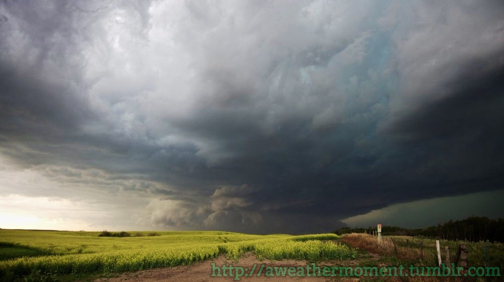
Supercell thunderstorm over SE SK / SW MB

HP Supercell just SW of Carlyle, SK on Saturday evening as the storm approached the Manitoba border. Credit: @lovestormsMB

This storm – for lack of any better terminology – looked vicious as it moved into Manitoba. It was tracking along Highway 13 and moved straight towards Reston – a town that has already had to deal with multiple severe storms this year already – and Pipestone, a town somewhat famous for the Pipestone tornado.

Unfortunately, it didn’t take long for word to come that there was certainly significant damage occurring under that storm. Environment Canada also issued a timeline for reports it received on the Manitoba side:

Location Time (Local) Report
Sinclair (7 km N) 6:00 PM Ping pong size hail, severe winds with trees down
Reston 6:49 PM Nickel hail, 42 mm rain
Pipestone 7:00 PM Tornado, significant damage
Pipestone (20 km E) 7:30 PM Tornado, golf ball hail
Hartney 8:00 PM Possible tornado

Dramatic photos began coming in from the Pipestone region as well:

HP Supercell Approaching Pipestone

Photo of the HP supercell near Reston, approaching Pipestone, MB. Credit: @lovestormsMB

Downed tree in Pipestone

Photo of a large tree snapped in half in Pipestone. Credit: Tim Smith / Brandon Sun

Mobile home thrown into the rink in Pipestone

Photo of a mobile home thrown into the rink in Pipestone. Credit: @Snipe_All_Day

Destroyed cattle shed in Hartney, MB

A destroyed cattle shed in Hartney, MB. Credit: @LD_StVital

The clean-up continues today in Pipestone and Hartney while damage continues to be assessed in southeastern Saskatchewan. Unfortunately for those in Saskatchewan there will be little time to recover as another potent setup for a severe storm outbreak will be in place Monday afternoon bringing, once again, a tornado, torrential rain and large hail risk. Regions in SW Manitoba should be a little safer this time. We’ll have the full details of that in tomorrow’s blog post.


  1. The “HP” in “HP supercell stands for ”high precipitation.” HP supercells often have obvious, dramatic structure form afar, but little of the internal workings are visible due to the copious amounts of precipitation falling out from them. HP supercells are extremely dangerous storms as any tornadoes they produce are often hidden from sight behind all the rain.  ↩

Elsewhere in Weather News: May 18th, 2013

Severe Weather Event South of the Border: Possible AWM Chase Sat/Sun

Trough

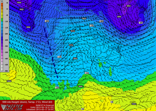
Negatively-tilted trough on Saturday late afternoon. (NAM) (Map source: Twisterdata)

The same system that will cause Southern Manitoba to have a rainy May long weekend is expected to produce a string of severe weather days across the Central US, starting today, continuing through at least Tuesday. A negatively-tilted longwave trough approaching from the west will help to provide the necessary wind shear, lift, and instability for severe storms to develop. A broad surface low with an extending cold front from Central South Dakota through Nebraska will be in place with a warm front slicing through north-east South Dakota. Another, stronger, low pressure center will be in place in Kansas with an extending dryline all the way down to Texas. These features will offer enough lift for severe storms on Saturday. This, combined with other severe weather ingredients such as a stiff low level jet (LLJ), high amounts of instability, deep low level moisture and low cloud bases is ideal for severe weather and tornadoes. The Storm Prediction Center has issued a Moderate Risk for Nebraska and Kansas with a Slight Risk extending up to North Dakota for their 2 Day Outlook as of Friday night.

Surface Analysis

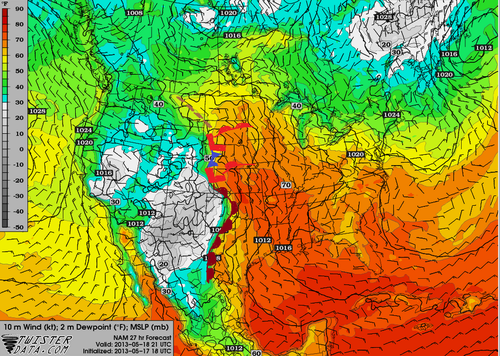
Surface analysis of the Plains. (Map source: Twisterdata)

As of Friday evening these ingredients appeared to be maximized in the vicinity of north-western Kansas near the Nebraska border. Storms will not be confined to this area though, as strong to severe storms will still be possible into South Dakota and down into Oklahoma, but whether they will be tornadic or not is still to be seen.

The ingredients that will be in place tomorrow in South Dakota:

  • Instability: about 2000J/Kg of MLCAPE (mixed layer)
  • Surface dewpoint: 18°C
  • Shear: 40 knots (0-6km shear)
  • LLJ: 20 knots
  • Lifting condensation levels (cloud bases): around 750m

With the LLJ being only 20 knots, an AWM Chase is still up in the air. If models tend towards a stronger LLJ, the chase will likely be on with a target somewhere in Central South Dakota.

Sunday also offers a significant severe weather threat as the trough continues its trek towards the east. Severe weather risk would extend into Southern Minnesota all the way down to Oklahoma. There is still some uncertainty about Sunday but it does look like another significant severe weather outbreak day for the Plains and Upper Mississippi Valley. Stay tuned in the comments section as the event approaches, updates will be posted.

AWM Chase is On!

Two of the AWM team members will be out chasing this setup along with a student from the University of Manitoba. You can keep up with their chase right here:

new TWTR.Widget({
version: 2,
type: ‘list’,
rpp: 30,
interval: 30000,
title: ‘May 18, 2013’,
subject: ‘AWM North Daktoa Chase’,
width: ‘auto’,
height: 500,
theme: {
shell: {
background: ‘#3c3c3c’,
color: ‘#eeeeee’
},
tweets: {
background: ‘#eeeeee’,
color: ‘#2c2c2c’,
links: ‘#489ce1’
}
},
features: {
scrollbar: true,
loop: false,
live: true,
behavior: ‘all’
}
}).render().setList(‘WeatherInThePeg’, ‘awm-team’).start();

Elsewhere in Weather News: December 23rd, 2012

From Snow to Tornadoes in the US this Week

This past week a large trough of low pressure swung through the eastern half of the United States bringing a wide range of weather; from blizzards in the Midwest, to tornadoes in the South-East and even dust storms in Texas.

The tornado, confirmed by the National Weather Station, occurred in the early morning hours on Thursday and cut a path of destruction through Mobile, Alabama. Preliminary reports indicate that the tornado was of EF-1 strength (between 138km/h and 178km/h winds) and had a path spanning 11 kilometers. It tore down roofs, uprooted oak trees and cut power off to about 10,000 residents. Most of the power was restored by Friday but the cleanup will certainly still be underway this weekend.

Blizzards, spanning from Nebraska to Michigan, accompanied this potent trough of low pressure and thundersnow was even experienced at times. Over 600 flights out of Chicago were cancelled and officials had to close various interstates across the Midwest, simply because it was too dangerous to travel. Here are a few of the higher snowfall amounts recorded as of Friday:

  • Gaylord, MI: 50cm
  • Madison, WI: 34cm
  • Des Moines, IA: 32cm

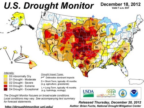
On Wednesday, near Amarillo, Texas, as the front came through it was accompanied with very strong winds (gusting to 80km/h) which managed to stir up a large dust storm. This dust storm was caused in part by the severe winds but also the severe drought currently occurring in the Southern Plains, including Amarillo, where the dirt is loose and can easily be picked up. The dust storm went through Interstate 27 producing near zero visibility and triggered a 23 vehicle pile-up.
By Saturday the trough will have moved off to Atlantic Canada, much of the US Midwest and Plains will experience below-normal temperatures as arctic air floods in from the Canadian Prairies.

Drought

Significant drought throughout the US Plains, both long-term and short-term. (Source: Drought Monitor, NDMC)

We again wish you happy holidays and all the best in the New Year!

Tornado Threat To Develop Over Southern Manitoba on Saturday

3km EHI Values

3km EHI Values. This measures the potential strength of a tornado should one develop. As can be seen, the GFS EHI values have gone off the chart over extreme SW Manitoba on Saturday afternoon.

A slow-moving low pressure system pushing into our region will set the stage this weekend for the potential of supercell thunderstorms capable of producing localized flooding, extremely large hail, damaging wind gusts and tornadoes. Read past the break to get all the details, our thoughts on the main threat areas, and to see updated information in the comments.

Jump to Live Twitter Feed

An extremely slow-moving long-wave trough has been slowly pushing it’s way eastwards this week. While it’s been a good distance from us, we’ve been able to enjoy the benefits of such a setup: plenty of nice, warm weather with comfortable humidity. Our friends in the Western Prairies haven’t had it quite as nicely; multiple rounds of storms have pushed into Southern Alberta & Southwestern Saskatchewan over the past couple days, bringing multiple tornadoes to Southern AB and torrential rain that caused localized flooding after 2-3” fell in a short period of time. Large hail was also reported in many storms across the Western Prairies, as well as with some severe thunderstorms that developed over SE Saskatchewan on Wednesday evening.

Entrance of this system in our region has been marked by the thunderstorms and showers that developed overnight. We should see most of these clear from the Red River Valley this morning or by early afternoon if they’re really tenacious. We’ll see a relatively pleasant afternoon, with some lingering cloud and temperatures in the low-to-mid 20’s. The dewpoint will be quite high, making it feel a little sticky, though.

The main surface low begins to move into our area on Saturday, pushing a warm front up from North Dakota into extreme Southern Manitoba. Using the basic MIST principles of thunderstorm forecasting:

  • Moisture: Plentiful. Surface dewpoints will be sitting near 20°C across Southern Manitoba, with 850mb dewpoints pushing up towards 15-17°C. This deep layer of moisture will provide plenty of energy for storms to work with.
  • Instability: The major inhibition to storms will be a layer of warm air at 700mb. Temperatures will climb to 10-13°C at 700mb on Saturday morning, however cooler air will push in later in the afternoon, helping destabilize the mid-levels. LI values of -8 to -11, combined with CAPE values anywhere from 2500 J/kg to 5500 J/kg are evidence of an extremely unstable atmosphere.
  • Shear: With a decent upper-level jet pushing in through the day, most areas across southwest and south-central Manitoba will see bulk shear values increase to 30-40kt by evening.
  • Trigger: A warm front draped across Southern Manitoba will be strong enough to initiate convection in the mid-to-late afternoon as the cap begins to erode.

Prog Tephi for SW MB

Prognosis tephigram for Southwestern Manitoba on Saturday afternoon. Note the extremely favorable veering wind profile present.

Models strongly disagree about the speed of this system, but agree that it has a very strong potential to produce damaging supercell thunderstorms capable of producing tornadoes. The greatest uncertainty, then, is where exactly the storms may form. Unfortunately, as I write this it’s still too early to tell exactly where the greatest threat lies. The slowest solutions would place the main risk over extreme SE Saskatchewan across SW Manitoba, while the quicker solutions would place the risk over SW Manitoba into the Red River Valley. Personally, I feel that the slower solutions are probably a little more true to what’s going to happen. With that in mind, here’s my threat area for Saturday:

Day 2 Storm Outlook

Day 2 Thunderstorm Outlook, valid Saturday afternoon through Sunday morning. This is subject to refinement as this system develops and more certainty exists on it’s track and speed.

A large MCS will likely develop as the whole system lifts northwards overnight, which will continue to provide a severe weather threat in the form of strong winds and large hail. It will push through the RRV by Sunday morning. We may see the threat for another round of thunderstorms on Sunday afternoon, however they are not expected to be severe. Things will finally cool off on Monday as the main upper low moves through and draws in cooler, dryer air from the west.

We’ll be sure to refine the forecast in the comments below as the day approaches. In addition, it looks like the AWM crew will be out chasing, so we’ll be sure to have some live updates should everything work out. Stay sky aware out there this weekend!


new TWTR.Widget({
version: 2,
type: ‘list’,
rpp: 30,
interval: 30000,
title: ‘June 9, 2012’,
subject: ‘AWM Storm Chase’,
width: ‘auto’,
height: 500,
theme: {
shell: {
background: ‘#3c3c3c’,
color: ‘#eeeeee’
},
tweets: {
background: ‘#eeeeee’,
color: ‘#2c2c2c’,
links: ‘#489ce1’
}
},
features: {
scrollbar: true,
loop: false,
live: true,
behavior: ‘all’
}
}).render().setList(‘buffaloseven’, ‘awm-team’).start();