Elsewhere in Weather News: January 18th, 2014

Severe Californian Drought

A severe drought has settled into a good part of the state of California and is starting to be of concern to residents as numerous brush fires have been sparking up this past week. A strong upper level ridge which has persisted over California for a good part of the past month has diverted all low pressure systems well north into BC. With this, a large area of California has been left dry and drought conditions have worsened significantly in the past month. The Drought Index shows that levels have reached extreme for over 50% of California, including Los Angeles. Los Angeles, on average, receives 80mm of rain during the month of January but they have yet to record any rainfall this January. To make matters worse, no pattern changes are in the forecast; the ridge is expected to remain in place at least until the end of January. Models show no precipitation in the foreseeable future for the southern half of California, which means that Los Angeles has a possibility of going the whole month of January without any precipitation.


Drought Index for the West Coast, ranging from abnormally dry (yellow) to exceptional (dark red). A good chunk of California is under extreme (red). (Source: USDA)

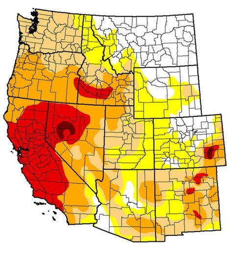
The snow pack in the Sierras has shown telltale signs of drought with only having 20% of the average snow water equivalents for this time (about 25mm of SWE). In this tweet sent out by the Boise NWS a drastic comparison in the snow pack can be seen over the Sierras. If no significant precipitation arrives before spring, California will be setting itself into a long-term drought.

A drought emergency had been issued for California, asking residents to limit their use of water. Bushfires have been flaring up due to the dry conditions, including the Glendora fire which is a fire that started on Thursday and has already burned 1,700 acres east of Los Angeles. Santa Ana winds gusting to 35km/h have been fueling the fire and will continue to do so until tomorrow, making it difficult for crews. Relative humidity in the area has a chance to dip as low as 5% during the day – making for ideal wildfire conditions. This has prompted the National Weather Service to issue a red flag warning east and northeast of Los Angeles.

Beautiful Weekend Ahead

The Red River Valley will receive a second shot of summer this weekend as warm air floods over the Prairies underneath an upper ridge.

500mb Winds valid Friday evening

500mb wind speeds valid this evening. A large upper ridge will bring warm weather to the Eastern Prairies.

Temperatures aloft continue to climb as an upper ridge advances eastwards across the Prairies. As a result, we’ll see a beautiful weekend ahead across the whole Red River Valley. Sunshine will dominate the skies over the next few days as temperatures climb into the low-to-mid 20’s. We’ll see highs near 23 or 24°C across the Red River Valley today, while things will really heat up tomorrow with highs closer to 26 or 27°C. Some cloud will begin to move into our region on Sunday ahead of an incoming system, which will limit our high to the lower 20’s, probably around 22 or 23°C.

Enjoy a nice summer-like break this weekend to our fall weather.

Warmer Weather Set to Return to The Red River Valley

After a prolonged and sudden stretch of normal to below-normal temperatures, warmer weather is on it’s way for Winnipeg.

500mb Winds valid Wednesday Evening

500mb wind speeds valid for this evening. Of note is the advancing upper ridge (denoted by the blue squiggle) over British Columbia.

The long-wave trough that has remained solidly parked over the Eastern Prairies over the past week is finally pushing off to the east, allowing a building upper ridge over British Columbia to spread eastwards into the Prairies and bring with it some milder Pacific air. With an incoming upper ridge, our chance for precipitation over the next few days is pretty much nil. We’ll see temperatures climb to about 17°C today, which will be a couple of degrees above our normal daytime high of 15°C for this time of year. Things warm up on Thursday as a warm front pushes through and we climb to a high of 23°C. Temperatures will remain in the low 20’s right through the weekend under sunny skies.

A Dry End to September

Rob put up a great summary on the precipitation situation for Southern Manitoba this month.

As of [September 24, 2012], only 4 mm of rain has fallen at Winnipeg airport this month, with no precipitation forecast all this week through the end of the month. If so, September will end up as the 2nd driest September on record in Winnipeg since records began 140 years ago in 1872.

I highly recommend you head over and read the brief summary Rob put up. It continues to look like we’ll be dry through the end of the month, so there’s a very good chance that Winnipeg may see it’s second driest September on record. We’ll have a complete summary for the month of September on Monday, October 1st in addition to our regular post.

Hot, Sunny Weather This Week

Winnipeg and the Red River Valley will be basking in hot, sunny weather this week as an upper ridge pushes it’s way across the Prairies. We’ll see a chance of thunderstorms on Thursday evening as a disturbance rolls through the RRV, but quickly return to sunny, warmer-than-seasonal weather.

850mb Temperatures this evening from the GEM-REG

850mb temperatures for this evening from the GEM-REG model. Warm air is building into S. MB bringing daytime highs near 30°C.

A broad southerly flow ahead of an incoming upper ridge has pumped temperatures up over Southern Manitoba back to the 30°C mark. 850mb temperatures will climb up to nearly 20°C today, which will allow our daytime high to soar towards 31 or 32°C. The warm air in place over us will also result in a dramatically warmer overnight low; while the past couple nights have dropped into the low-to-mid teens, we’ll see the mercury barely dip below 20°C tonight.

The normal daytime high for late August in Winnipeg is about 24°C. The normal overnight low is about 11°C.

Thursday will be another warm day, however an incoming shortwave will slide along the International Border through the day, bringing some showers on Thursday morning to SW MB and the risk of an isolated thunderstorm to the Red River Valley, from the Winnipeg area all the way south to Fargo. If storms develop, they’ll develop late in the afternoon along a weak trough line that’s expected to develop in response to the upper feature. Ultimately, I think that most of the storms will remain south of the border with only a very slight chance of anything popping up on the Manitoba side of the RRV. Scott’s Southern Manitoba Mesonet will be a great way to track the trough through the afternoon to see if the threat for storms has passed by you. Despite the heat that will be present with daytime highs near 30°C, dynamics look fairly weak and I do not expect that any storms that may develop will become severe.

We’ll see temperatures dip to around 15°C on Thursday night. On Friday, we’ll see plenty of sun and daytime highs continuing to be near 30°C.

For the weekend, it looks like a cold front will sweep into the province on Saturday, bringing with it some showers and cooler weather; daytime highs look to be in the low-20’s for Saturday. Temperatures look to rebound quickly on Sunday, though, with highs pushing back to the high-20’s. So despite our rather cool start to the month, we may yet come out with our 14th consecutive month of above-normal temperatures in Winnipeg. 5 days out of the next 7 are forecast to have daytime highs at least 3°C above normal, and overnight lows look to remain above normal as well.