Warm-up Just Around the Corner

After a couple weeks of frigid conditions, a warm-up is on the way. However, we’ll have to deal with another couple days under an arctic air mass before warmer weather arrives.

Monday morning will be extremely cold in southern Manitoba

Monday

Monday
-22°C / -26°C
Mainly Sunny

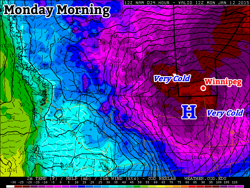
Today will be very cold in southern Manitoba. Morning low temperatures will be in the minus thirties, with daytime highs remaining stuck in the minus twenties. The wind will gradually pick up throughout the day, slowly adding a more significant wind chill factor. We’ll be under a strong surface high pressure system, so at least it will be sunny!

Tuesday

Tuesday
-18°C / ⇑ -15°C
Mainly Cloudy

Tuesday will be the last really cold day for awhile. Morning temperatures will be in the minus twenties, with a gusty south wind, making it feel closer to -40. Temperatures will slowly rise during the day, reaching the upper minus teens by late in the day. The wind will remain gusty though, so it will still feel pretty cold. However, temperatures will continue to rise on Tuesday night as that southerly flow brings in warmer air, setting up much nicer weather for Wednesday.

Wednesday

Wednesday
-2°C / -10°C
Mainly Cloudy

Wednesday will finally feature that long-promised warm-up. Temperatures will climb into the low-minus single digits (maybe even up to 0C in some areas). Unfortunately, it will be a cloudy day, but I’m sure most people will take the warmer conditions over a bit of sun.

Long Range

The long range forecast continues to show a prolonged period of warmer weather beginning this week. The average high at this time of year is -13C, so that does not mean every day will be near the freezing mark, but most days should be in the minus single digits.

A Brief Reprieve From the Deep Freeze

After a record cold morning on Sunday, we’ll see a dramatic warm-up to start the week.

Temperatures Will be Warming Up on Monday

Temperatures Will be Warming Up on Monday

Monday

Monday

Chance of Flurries in the Morning, then Clearing
-5°C / -14°C

Today will be the warmest day of the week with temperatures climbing into the minus single digits. There may be a few flurries in the morning, before skies clear later in the day. It will be a windy day too, as westerly winds help to bring in that warmer air. Winds will be 20-30km/h gusting to 40-50km/h.

Tuesday

Tuesday

Mainly Sunny
-13°C / -15°C

Temperatures will cool down a bit for Tuesday, with highs in the low minus teens. It will not be as windy as Monday though, so conditions will remain fairly pleasant.

Wednesday

Wednesday

Mainly cloudy. Chance of flurries.
-8°C / -24°C

A low pressure system is expected to pass through Manitoba on Wednesday, signalling the beginning of the end of this little warm spell. At this point it appears that this system will pass far enough to our north that we won’t see much, if any, snow with it – although that may change. Temperatures on Wednesday look to be around -10C with fairly light winds. A cold front associated with this low will move through Southern Manitoba on Wednesday afternoon and evening, allowing another arctic airmass to surge into the region.

Long Range

Models suggest we will continue to see arctic air dominate our weather until Christmas. There may be the odd break in the deep freeze here and there, but in general there are no lengthly warm-ups currently in our future.

A Return to Summer?

After several weeks of weather that resembled fall more than summer, we may begin to see hot weather return.

A Surface Ridge of High Pressure Will Slide Southward on Monday

Monday

Monday

Mix of Sun and Cloud. Slight Chance of Showers.
23°C / 6°C

However, before we see hot weather again in Southern Manitoba, we’ll have to deal with yet another burst of polar air. Another surface ridge will drop down from the north on Monday, which will result in reasonable, but still cool conditions. High temperatures on Monday will be in the low twenties, though there may be some readings in the mid twenties along the International border. There might be a few showers around during the afternoon and evening as cool air aloft generates a bit of instability. The wind will generally be light and from the north, though it will be a bit breezier in open areas.

Tuesday

Tuesday

Mainly Sunny
22°C / 7°C

Tuesday looks to be just a slightly cooler version of Monday. Highs will be in the low twenties once again with with a light northerly wind. Shower activity looks less likely on Tuesday, but there may still be some bubbly cloud cover as the ground heats up during the day.

Wednesday

Wednesday

Mainly Sunny
23°C / 10°C

At this point there is a bit of uncertainty as to how warm Wednesday will get. Some weather models suggest we’ll see temperatures in the mid to upper twenties, while others suggest temperatures in the low twenties are most likely. I’m leaning towards the later of those two scenarios, as I don’t think the warm air will move in quite that quickly. As a result, I’m once again calling for temperatures generally in the low twenties with variable cloudiness through the day. The area with the best chance of seeing some warmer conditions on Wednesday will be portions of Western Manitoba where that warmer air may filter in a bit during the afternoon and early evening.

Long Range

The longer range forecast is where things begin to look more promising. Models suggest that we’ll stand a good chance of seeing high temperatures in the upper twenties on Thursday. If we’re lucky, we may take a run at the 30C mark as early as Friday, but that type of heat looks more probable on the weekend right now. There have also been some hints in the models that this heat may also be accompanied by elevated humidity levels. Given that the model I’m looking at for this (GFS) is notorious for being too humid, I’m not going to get overly caught up on this for now. Once we get closer to the weekend, and more accurate information is available, this part of the forecast can be more appropriately addressed.

Cold and Calm

This week will start out cold and fairly benign. Our next chance for snow will come midweek.

Warmer air will be advected into Southern Manitoba on Tuesday night

Warmer air will be advected (moved in via wind) into Southern Manitoba on Tuesday night

After another cold morning on Monday, temperatures will warm up a bit during the day. Highs on Monday afternoon should be in the low to mid minus teens, a significant improvement from Sunday’s minus twenties, but still chilly. The wind will be a bit breezy from the south on Monday, but wind chills values won’t be significantly colder than the air temperature (except in open areas). A weak low pressure system will pass through Southern Manitoba on Monday night, bringing some cloud cover along with it. As a result, temperatures on Monday night will be warmer than those on Monday morning as the cloud prevents heat from escaping from the surface. Unfortunately, temperatures won’t increase much on Tuesday, as we only see temperatures rise a few degrees from the morning lows. Our next little warm-up will begin Tuesday night as an approaching low develops a southerly flow over Southern Manitoba allowing temperatures to rise overnight.

As the low moves into (or just south of) Manitoba on Wednesday, it will bring our next chance for snow. At this point models suggest we may see as much as 5 to 10cm from this system, or perhaps as little as 2cm. Additionally, there are indications that we may see another weak system pass by on Thursday, bringing another small bought of snow. At this point it is too early to say how much snow to expect from these systems, but 5 to 10cm in total for both looks like a good initial “guess”. More information about the potential for snow will be available as the week progresses.