March Heat Wave Continues

Last week saw Winnipeg bathing in historically abnormal warm weather that shattered numerous daily record high temperatures as well as breaking the record for the warmest day in March since 1872. Thunderstorms then pushed through Winnipeg Monday night, lighting the city up with intense lightning and settling the dust with 10-15mm of rain. On the back side of these storms, cooler air pushed over Southern Manitoba, giving us a daytime high yesterday around 13°C cooler than Monday, which amazingly was still ~10°C above normal for this time of year. Despite the “cool” day, the heat wave isn’t over yet, with temperatures set to rebound to threaten more daily high temperature records over the next few days.

Temperature Records Smashed

Day New
Record
Old
Record
Previous
Record Year
Sun Mar. 11 12.8°C 12.5°C 1981
Mon Mar. 12 9.7°C 7.2°C 1922
Thurs Mar. 15 14.4°C 11.1°C 1927
Fri Mar. 16 19.9°C 12.4°C 1981
Sat Mar. 17 19.2°C 12.8°C 1938
Sun Mar. 18 20.9°C 14.4°C 1910
Mon Mar. 19 23.7°C 18.9°C 1938
Table of daily record high temperatures over the from March 11, 2012 to March 19, 2011.

Winnipeg saw unprecedented heat for the middle of March which broke daily high temperature records on 7 of 9 days. Many records were broken by at least 5°C, and temperatures peaked on Monday, March 19 at 23.7°C, which broke the record high temperature for that day by 4.8°C and broke the old record for the hottest day in March in Winnipeg of 23.3°C set on March 27, 1946. On Sunday, March 18th, Winnipeg had a high of 20.9°C, which was the earliest 20°C reading on record.

Since Friday, Winnipeg has recorded 4 straight days over 19C. In the previous 140 years of March records, that mark has been reached on only 4 occasions in Winnipeg. In other words, it took only 4 days during this warm spell to match what took 140 years to accomplish.
Rob’s Obs Blog

Perhaps even more impressive was how far above normal temperatures have been. Typically, for the second week of March, normal daytime highs are around -1°C to 0°C. With temperatures rocketing into the high teens, Winnipeg spent almost an entire week with temperatures at least 15°C above normal.

Temperature Anomolies

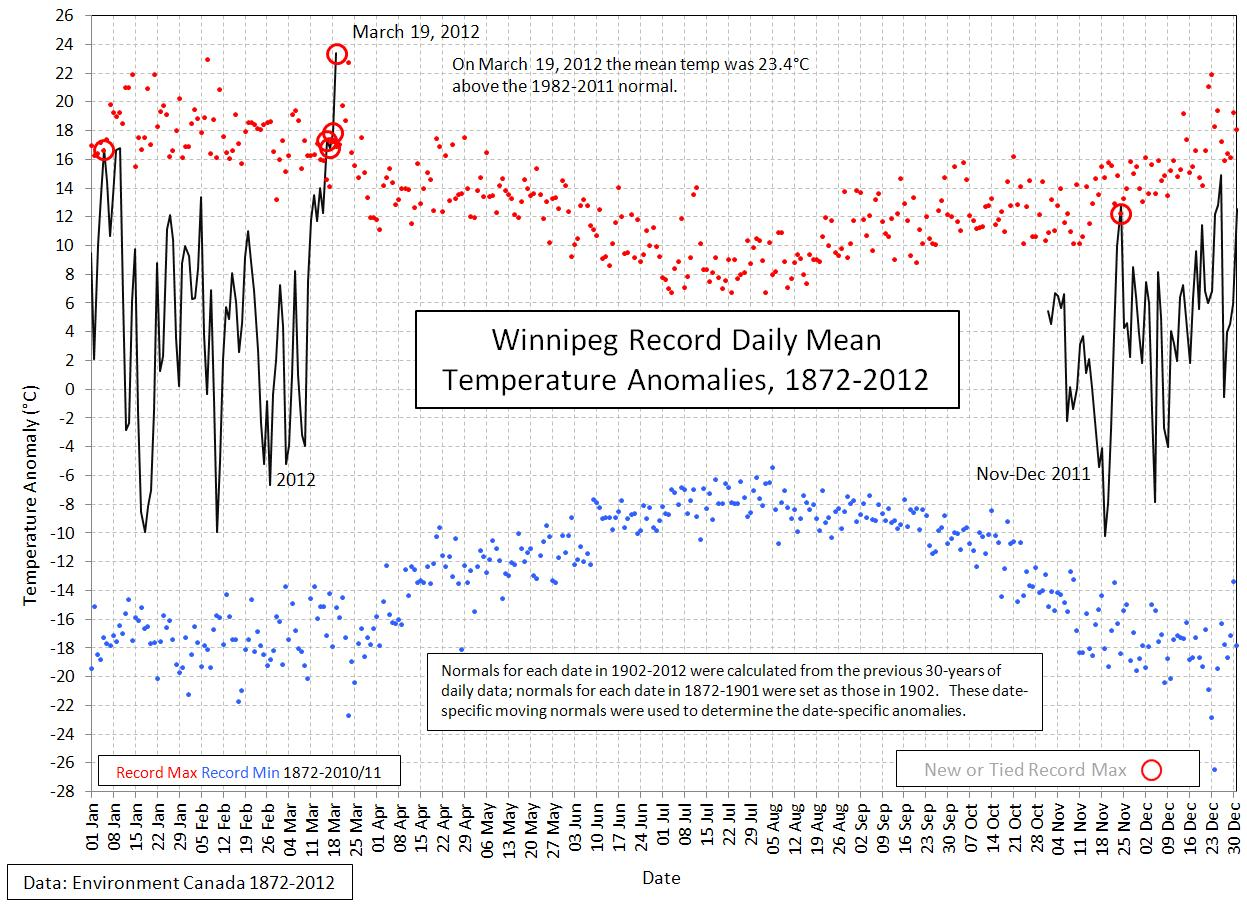
Winnipeg Record Daily Mean Temperature Anomalies, courtesy Danny Blair – University of Winnipeg

In fact, as the above graph shows, Winnipeg set a new all-time record for temperature anomaly. On March 19th, the daily mean temperature was 23.4°C above normal, which was a higher value than any other day of the year. Winnipeg had never been so far above normal temperatures as Monday.

The Weather This Week

So what’s in store? After a cool Tuesday, temperatures are set to rebound today and tonight, with milder air once again pushing into our region. Today will bring plenty of sunshine with a breezy southwest wind around 30km/h and a high of 14°C. A warm front will push northwards through Southern Manitoba on Thursday, bringing a mix of sun and clouds and temperatures in the upper teens. This warmth will once again bring us the chance of breaking more daily record high temperatures. Currently, Thursday currently looks to be the most likely day we may break a record high temperature. For the next few days, the daily record high temperatures are:

Day New
Record
Old
Record
Previous
Record Year
Wed Mar. 21 ??.?°C 19.4°C 1938
Thur Mar. 22 ??.?°C 18.3°C 1878
Fri Mar. 23 ??.?°C 22.8°C 1910

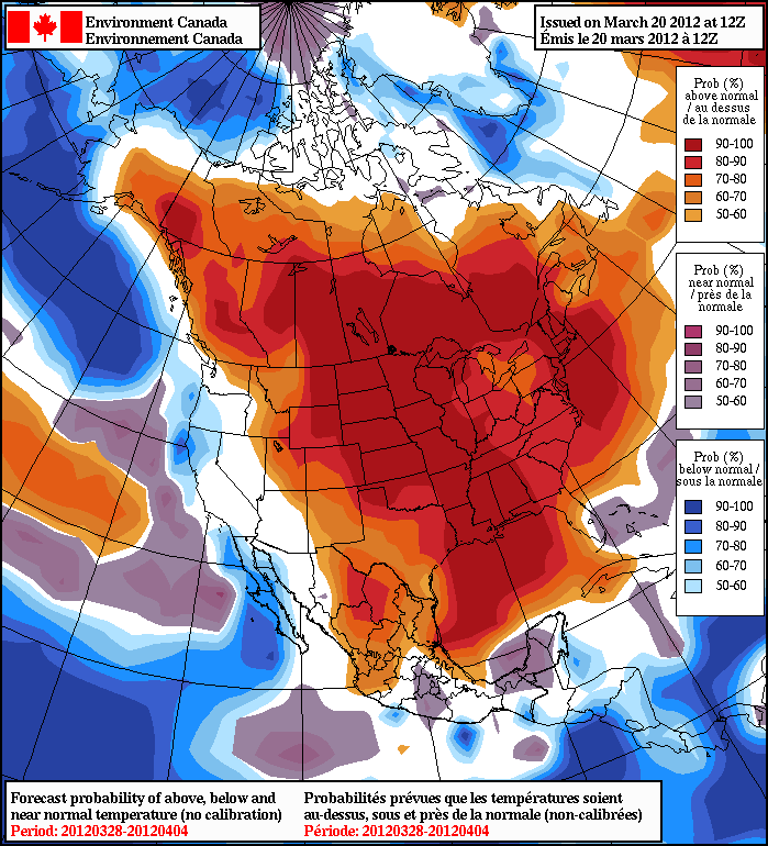
How about the long term? Ensemble guidance continues to smother central and eastern North America with 90-100% chances of temperatures being above normal.

Anomaly Outlook

NAEFS 8-14 Day Temperature Anomaly Probability Outlook, valid March 28 – April 4.

With probabilities that high, while we may have a chilly day here or there, we’ll be hopping right towards summer with little risk of a disheartening return to winter.
March Madness

What a week it has been! Temperature records have fallen, our snow cover has disappeared, and thunderstorms are in the forecast – the question is what next?

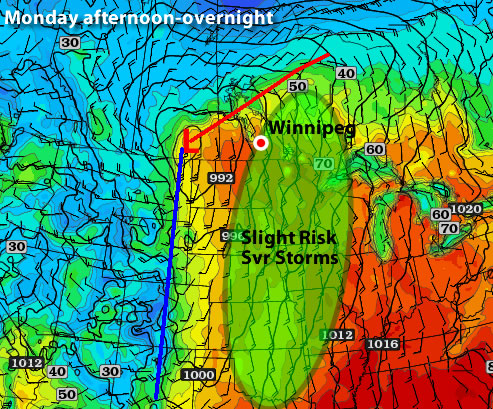
Map showing the risk of thunderstorms on Monday, March 19, 2012

The light green region shows where there is a slight risk for severe thunderstorms on Monday

This week will start out on a warm and possibly stormy note. Monday’s temperatures are expected to be in the low to mid twenties across Southern Manitoba with a risk of thunderstorms. If Winnipeg records a high temperature on Monday that is greater than +23.3C the city will record a new all-time record high for the month of March. The previous all-time record high of +23.3C was set on March 27, 1946. On Sunday Winnipeg set a new record for the earliest ever occurence of a 20C high temperature, beating the old record of +22.8C set on March 23, 1910.

Day New
Record
Old
Record
Previous
Record Year
Sun Mar. 11 12.8°C 12.5°C 1981
Mon Mar. 12 9.7°C 7.2°C 1922
Thurs Mar. 15 14.4°C 11.1°C 1927
Fri Mar. 16 19.9°C 12.4°C 1981
Sat Mar. 17 19.2°C 12.8°C 1938
Sun Mar. 18 20.9°C 14.4°C 1910
Mon Mar. 19 23.7°C 18.9°C 1938
Table of daily record high temperatures over the past week.

As you may have noticed on Sunday, the humidity has risen significantly in the Red River Valley and South-Eastern Manitoba. When that extra moisture in the air is combined with warm temperatures, thunderstorms become possible. A strong jet stream is currently in place over Southern Manitoba, setting the stage for some potentially strong storms later on Monday afternoon into the evening. There will be a “lid*” over the atmosphere on Monday preventing storms from developing earlier in the day. This “lid” may or may not come off the atmosphere later on Monday. Whether or not the “lid” comes off will determine if storms can develop. Any storms that form shouldn’t be particularly strong, with the strongest storms only being marginally severe at best. However, with the way this March has gone it is best to assume that anything can happen – including stronger than expected thunderstorms.

The rest of the week looks a bit more “normal”. Actually temperatures will remain well above-normal but will seem more reasonable for this time of year. It looks like most days this week should feature high temperatures in the low double digits. As a result more temperature records will be threatened over the coming days, but they won’t be broken by the huge margins seen on the weekend. It doesn’t look like any more 20C days are imminent, but we certainly could hit 20 degrees again before the month is over.

In the long range models show continued warm weather through the end of March. With our snow cover gone it will be very difficult for conditions in Southern Manitoba to reach below-normal values. We’ll have to wait until our seasonal averages rise by several degrees before below-normal weather is even possible again. Bear in mind that above-normal temperatures don’t necessarily give way to beautiful weather conditions all the time. Models do hint at less settled weather over the next 7-10 days, which means we could get our first significant rain storm of the season (fingers crossed that it doesn’t turn into a snowstorm!)

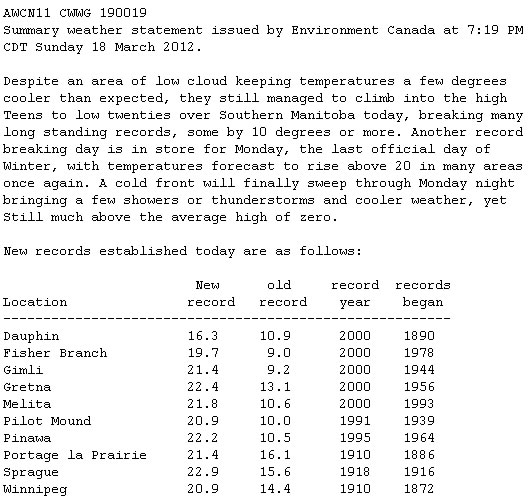
Here is Environment Canada’s statement regarding broken temperature records on Sunday:

March 18, 2012 High Temperature Records

New high temperature records set on March 18, 2012

*A “lid” being on the atmosphere is simple way of referring to atmospheric capping. Capping is when there is warm air above the ground which prevents air near the surface from rising. We know that warm air rises and cold air sinks, but warm air only rises if it is warmer than the air around it. Therefore if the air at the surface is relatively warmer than the air aloft it will rise and if the air aloft is relatively warmer than the air at the surface the surface air won’t rise. On Monday the air aloft will be relatively warmer than the air at the surface for most of the day. Storms will only develop if colder air moves in aloft allowing the surface air to rise up high into the atmosphere. This may or may not happen, causing the thunderstorm forecast to remain uncertain.


Elsewhere in Weather News

Record Breaking Heat Wave Across the United States

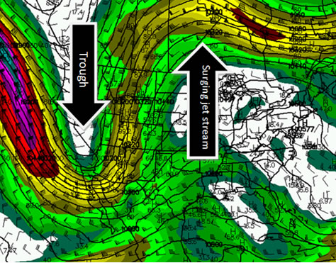
The heat wave that currently has Southern Manitoba feeling more like May than March has also taken hold of much of the United States this past week. The unusual warmth is caused by a large surge in the jet stream over most of the US Plains, Midwest and East Coast. The jet stream, which acts as a fence between the cold air masses and warm air masses, is part of the reason why the US is experiencing its first major heat wave of the year. As the jet stream surges in the Plains and East, a trough (dip) in the jet stream over the west coast is bringing unseasonably cold air to the region and much precipitation with it.

250mb wind speeds, showing the jet stream, Sunday March 18th. (Source: Brad’s Model Viewer/COD)

250mb wind speeds, showing the jet stream, Sunday March 18th. (Source: Brad’s Model Viewer/COD)

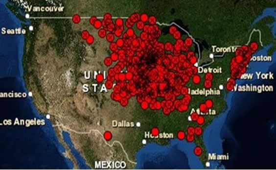
Since the beginning of March the US has seen more than 1700 new records reached, including some records that weren’t even close to the previous records. Here are some notable ones from this past week across the US:

  • International Falls, MN: Previous record = 13°C, New record = 25°C, Average = 1°C
  • Marquette, MI: Previous record = 16°C, New record = 24°C, Average = 3°C
  • Minneapolis, MN: Previous record = 17°C, New record = 23°C, Average = 4°C

    Map showing record highs Wednesday, March 14th. 307 record highs were broken and 97 tied. (Source: National Climactic Data Center)

Map showing record highs Wednesday, March 14th. 307 record highs were broken and 97 tied. (Source: National Climactic Data Center)

As the jet stream shifts east early this week the spell of record-breaking temperatures will end for the plains, giving way to strong thunderstorms as the cool air from the west collides with the moist gulf air present over tornado alley. However, the Midwest and East Coast will remain near record breaking temperatures for a couple more days before cooler air arrives (but still above normal) and ushers showers in with it.

A Record-Breaking Weekend on the Way

Winnipeg will see a record-breaking weekend ahead with potentially unprecedented heat on the way. 3 daily record high temperature records have already been broken this week, and at least another 3 will be broken over the next few days. In fact, there’s also a chance that we’ll see warmer weather by the beginning of next week than we’ve ever seen in March.

March has been nearly unprecedentedly warm this year, with temperatures quickly soaring 10-15°C above normal after a decidedly unpleasant snow storm started the month with more than 6” of snow in many locations. Plenty of uncertainty existed as to how warm it could get with so much snow on the ground, but extremely warm air aloft combined with light winds (and a few breezy days) have done an incredibly good job at eroding the snow pack over Southern Manitoba. The following slides show the quickly eroding snowpack over a mere 4 days:


  • 2012-03-11-morning

    Evening of March 11th

  •     

  • 2012-03-11-evening

    Evening of March 11th

  • 2012-03-12-evening

    Evening of March 12th

  • 2012-03-13-morning

    Morning of March 13th

  • 2012-03-13-evening

    Evening of March 13th

  • 2012-03-14-morning

    Morning of March 14th

  • 2012-03-14-evening

    Evening of March 14th

  • 2012-03-15-morning

    Morning of March 15th

Manitoba Snow Melt: March 11-15, 2012

  $(window).load(function() {
    $(‘.flexslider’).flexslider();
  });
In a mere couple days almost all the snow disappeared from Southern Manitoba, quickly negating it’s potential to hold our temperatures back. As a result, we’ve broken several daily high temperature records this week, and are on track to break several more.

Day New
Record
Old
Record
Previous
Record Year
Sun Mar. 11 12.8°C 12.5°C 1981
Mon Mar. 12 9.7°C 7.2°C 1922
Thurs Mar. 15 14.4°C 11.1°C 1927
Fri Mar. 16 19.9°C 12.4°C 1981
Sat Mar. 17 19.2°C 12.8°C 1938
Sun Mar. 18 ??.?°C 14.4°C 1910
Mon Mar. 19 ??.?°C 18.9°C 1938

So where’s this warmth coming from?

850mb Temperatures

850mb temperatures valid 00Z Saturday (Friday evening) from the GEM-REG.

As a long-wave trough approaches the west coast, a strengthening southerly flow will begin to advect plenty of heat and, surprisingly, moisture into the Northern Plains and Southern Manitoba. This will be enhanced by the record-shattering heat that’s been in place over the Central and Eastern US already, putting us within a stone’s throw of breaking another substantial record: the warmest day ever recorded in March in Winnipeg.

We’ll see exceptionally warm temperatures over the next few days:

  • Today: 22°C
  • Saturday: 18°C
  • Sunday: 21°
  • Monday: 25°C

These forecast highs will definitely put us in some of the hottest days ever in March in Winnipeg:

The top 3 hottest days ever recorded in Winnipeg in March are:

  1. March 27, 1946: 23.3°C
  2. March 23, 1910: 22.8°C
  3. March 28, 1938: 20.6°C

Monday will give us a decent shot at breaking the all-time hottest day ever in March in Winnipeg, but we’ll see how that goes a bit closer to the day. Today and Sunday will definitely find a place in that list, though.

And last but not least, there exists a chance for thunderstorms! Sunday night brings with it a chance of thunderstorms overnight. Several of the ingredients we look for to predict nocturnal thunderstorms are in place:

  • Moisture: Dewpoints at 850mb are progged to be ~ 15°C
  • Instability: Models vary, but we could see around 1000 J/kg of MLCAPE Sunday night.
  • Shear: We’ll have shear galore: 50-60kt of 0-500mb bulk shear
  • Trigger: An advancing warm front.

The cap may be a concern, and there may not be quite enough instability to get things going; there is certainly a non-zero chance though. We’ll keep updates on temperature records and the chance for thunderstorms in the comments as the weekend progresses!

Continued Mild Weather

The Red River Valley will continue to see temperatures well above normal for this time of year through the remainder of the week, with daytime highs expected to climb into the mid-teens by the end of the week.

Day New
Record
Old
Record
Previous
Record Year
Sun Mar. 11 12.8°C 12.5°C 1981
Mon Mar. 12 9.7°C 7.2°C 1922

Winnipeg has been basking in the warmth the past few days, setting new daily record high temperatures on Sunday and Monday. This record-setting “heat wave”, with temperatures a good 10-15°C above normal for this time of year, is a result of a persistant long-wave trough off the western coast of North America. While providing cool, wet weather to many places in B.C., Washington State and Oregon, the southwest flow aloft is allowing warm air to make it’s way up the Plains into the Southern Prairies.

Fortunately for us, the long-wave pattern isn’t expected to change any time soon. We’ll see a cooler day today with highs “only” around 7°C as a result of a weak cold front that passed through overnight. Temperatures will begin to rebound quickly, though, with warm air at 850mb spilling northwards into the southern Prairies on Thursday and Friday. This will push daytime highs up to the mid-to-high teens by the end of this week with a good chance that we’ll break record daily daytime highs on Friday and Saturday. Today will be breezy with west winds gusting potentially as high as 70-75km/h. Winds will be calmer for the remainder of the week.

And last but not least, a quick look to the long-term…

Long-Range Temperature Anomoly Forecast

Temperature Anomoly Outlook for March 21-28. Blues indicate hgiher probabilities fo cooler than normal weather while reds indicate higher probability of warmer than normal weather.

Ensemble forecasts continue to forecast near-100% chances of above normal temperatures right to the end of this month. What are normal temperatures for Winnipeg in a couple weeks? The average daytime high for March 28th is 3.0°C; so we could be enjoying mid-teen temperatures, perhaps even close to 20°C, for much of the rest of March.

So far March is living up to “in like a lion, out like a lamb.” Enjoy that beautiful weather!