An Oasis on the Horizon?

After weeks of dry weather, some rain is finally on the way. However, for those desperately wanting rain, the water works may only come after the rain has ended.

A Low Pressure System will Spread Rain Over the Northern Plains on Monday

Monday

Monday

Mainly cloudy. Chance of showers.
23°C / 14°C

Today will see rain over some parts of Southern Manitoba as a powerful upper low approaches the region. This system will tap significant moisture over the Northern Plains, generating an area of moderate to heavy rainfall over the Dakotas. The core of this rain will slide mainly south through North Dakota and Minnesota, however the northern fringe of it may clip areas along the International Border up into south-eastern Manitoba. In these border regions rainfall amounts will be very hard to predict in advance, but a reasonable estimate would be for 5 to 15mm for the entire day. Actual amounts could be slightly higher or lower than this depending on the track of the system. In the rest of Southern Manitoba, little to no rain is expected. There will be a constant threat of showers today and tonight, but most areas including Winnipeg, should see very little if any rain. Other than the rain it will be a cloudy, but mild day, with light winds.

Tuesday and Wednesday

Tuesday

Mix of Sun and Cloud. Chance of Showers or Thundershowers.
27°C / 10°C
Wednesday

Mainly Sunny
21°C / 6°C

Tuesday should be a fairly nice day in Southern Manitoba. Skies will be a mixture of sun and cloud with temperatures in the mid to upper twenties. Late in the day a cold front will come through, likely triggering some showers and thunderstorms. These storms are not expected to be severe.

Not surprisingly, Wednesday will be a cooler day as colder air moves in behind that cold front. High temperatures will be in the low twenties with gusty north-westerly winds. Some fair weather cumulus clouds may develop during the day, but otherwise it will be mainly sunny.

Long Range

The long range outlook is a bit ambiguous at this point. It appears that we’ll probably see conditions begin to warm up around the weekend, only to be knocked back down by another cold front later on the weekend or into next week. This sort of up and down pattern makes forecasting fairly tough, so rather than making any sort of grand prediction I’ll just suggest that we’re in for a variable pattern with some warm weather interspersed with cooler periods.
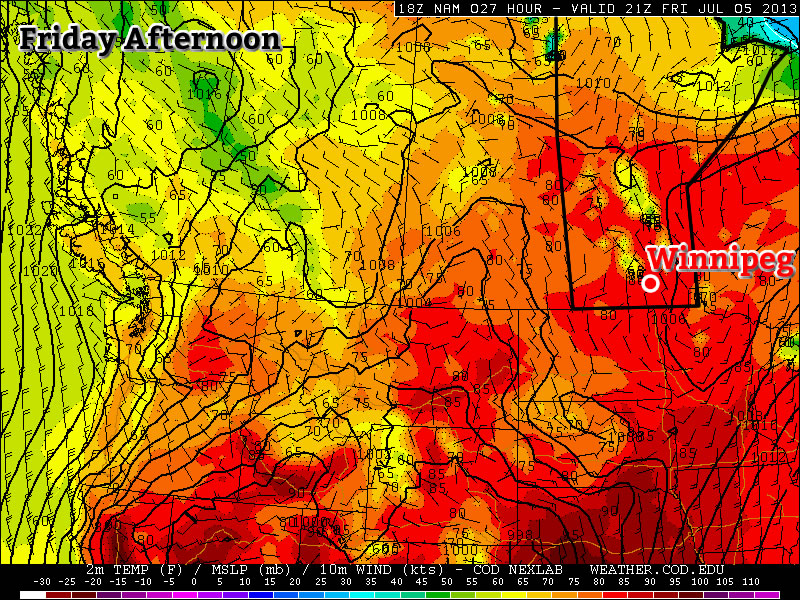
Generally Nice Weekend In Store

A generally nice weekend is in store, with the exception of possible rain or storms on Saturday.

Areas outlined in red over Manitoba are forecast to be between 27 and 29C by the NAM model

Friday

Friday

Mainly Sunny
28°C / 18°C

Today will be another beautiful day in Southern Manitoba. High temperatures will be in the upper twenties under mainly sunny skies. The wind will be fairly light and from the north.

Saturday

Saturday

Mix of Sun and Cloud. Chance of showers or thunderstorms.
27°C / 15°C

Saturday looks to be the only possible wrench in the weekend forecast. It appears that skies will be a mix of sun and cloud or mainly cloudy on Saturday with a chance of rain and risk of a thunderstorm. Any storms that roll through will be non-severe, but possibly enough to cause disruption to outdoor activities. It is possible we may entirely avoid rain and thunderstorms on Saturday, so hopefully that will be the case. If we steer clear of precipitation, temperatures on Saturday may reach the upper twenties in Southern Manitoba. However, if it stays cloudier then highs will end up in the mid twenties.

Sunday

Sunday

Mainly Sunny
27°C / 15°C

Sunday should be mainly precipitation free in Southern Manitoba, except for perhaps a stray shower or thundershower. Temperatures are expected to be in the mid or upper twenties with light winds and mainly sunny skies.

Long Range

As we move into next week the heat is expected to crank up once again. Temperatures in the upper twenties or near thirty degrees are expected on most days. Models hint at the potential for storms later in the week, but it is too early to discuss that any further.

A Chance to Dry Out

Wet weather will finally give way this weekend to sunshine and warm temperatures as an upper ridge building into the western Prairies induces a dryer, more stable northwesterly flow aloft over Manitoba.

Friday

25°C / 14°C
A few morning showers giving way to afternoon clearning.
Saturday

27°C / 14°C
Mainly sunny.
Sunday

28°C / 15°C
Sunny.

We’ll see a few morning showers today as the dying remnants of an upper low cycle their way out of the province. Once the scattered showers end in the morning, skies will begin to gradually clear through the afternoon. We’ll see a high of 25 or 26°C with winds out of the north at 20–30km/h. We’ll see clear skies tonight as temperatures drop to around 14°C.

A high pressure system will begin to push eastwards across the Prairies this weekend which will bring some beautiful, dry weather to Southern Manitoba. Temperatures will climb into the high 20’s this weekend under sunny skies with no chance of rain in sight. Overnight lows will dip to around 15°C.

The next chance of precipitation looks to be in the first half of next week as a slow-moving low pressure system meanders across the Prairies. Until then, enjoy a sunny, warm and dry weekend!

A Brief Reprieve From Storms

It’s been a wet and wild week in Southern Manitoba as muttiple rounds of thunderstorms have pummeled the region with heavy rain. On Thursday, 75mm of rain fell in southwest Winnipeg, causing substantial amounts of flooding to neighborhoods, schools and retail locations. On Friday night a area of heavy rain and thunderstorms pushed into Western Manitoba bringing as much as 175–200mm of rain to some regions in the southwestern portion of the province. The town of Reston, MB has declared a state of emergency after about 7.5” of rain fell on Friday night (~ 190mm). Approximately 2/3rds of the town’s population has been affected by the flood waters that engulfed the town as it’s drainage system simply could not keep up with the intense downpour.

image-1

The village of Reston, MB has declared a state of emergency after heavy rain caused significant flooding. Photo credit: Jillian Coubrough/CBC

On Saturday evening, an intense line of thunderstorms developed along the western escarpment of the Red River Valley and remained stationary for almost 3 hours. The hardest-hit areas just west and northwest of Portage la Prairie where – as evidenced by RADAR-estimated rainfall accumulations and a report from the town of Westbourne, MB – as much as 225mm (9”) of rain fell. On Sunday, an area of rain and thunderstorms lifting northwards through western Manitboba brought another 50–75mm of rain. This additional rainfall in an already waterlogged region has brought more overland flooding and caused mutliple highways to be closed near Riding Mountain National Park.

But a reprieve is in store for Southern Manitoba as the upper low that has been drawing a moist, unstable air mass from the Gulf of Mexico and brought catastrophic flooding to Calgary and southwest Alberta finally moves out of the region. This will allow a slightly drier, more stable air mass to move into Southern Manitoba on Monday. Things are not meant to last, though, as the heat and moisture is set to return on Tuesday as another system pushes into the Prairies and brings the storm threat back.

The Next Few Days

Monday

26°C / 15°C
Mainly Sunny
Tuesday

29°C / 18°C
Hot and humid. Thunderstorms possible in the evening & overnight.
Wednesday

26°C / 15°C
Mostly cloudy; showers likely.

We’ll see a beautiful day today with mainly sunny skies. A westerly wind will bring in slightly dryer air which will help things feel a little more comfortable as we head to a high of around 26°C. Skies will be mainly clear tonight as we drop to around 15°C.

Heat and humidity will begin to build in on Tuesday as a southeasterly wind develops and begins drawing Gulf moisture northwards again. Dewpoints should climb back towards 19–20°C as our temperature soars into the high 20’s. While the high will top out around 28 or 29°C, when combined with the humidity it will feel much closer to 35°C out there. An approaching trough will push into SW Manitoba through the afternoon and move into the Red River Valley in the evening.

image-2

CAPE values are expected to climb towards 2500–3000J/kg in southwestern Manitoba on Tuesday.

Thunderstorms should fire along this feature in the afternoon and pretty much every single thunderstorm parameter looks fantastic. CAPEs are expected to exceed 2500J/kg, LI values are expected to be beween –5 and –10°C, surface dewpoints should pool to around 20°C along the trough and a decent shear profile will be in place. It looks likely that any storms that develop will likely have the potential to become severe with threats of large hail, torrential rain and tornadoes. The storms will likely grow into a line of storms as they slowly progress eastwards towards the Red River Valley, with a good chance of heavy showers or thunderstorms in the late evening or overnight here in Winnipeg.

On Wednesday we’ll be stuck underneath a low pressure complex. The overnight convection should clear out through the morning hours then we’ll move into a mix of sun and cloud with scattered showers through southern Manitoba. We’ll see a high climb into the mid–20’s and clearing skies overnight with a low near 15°C.

Rest of the Week

It looks like we’ll finally move into a dryer pattern for at least a few days as a weak upper ridge pushes into the Prairies. Temperatures will be mid–20’s with significantly dryer air in place making for some pleasant, warm and comfortable summer weather. A few thunderstorms may be possible throughout the latter half of the week, but with less moisture available they shouldn’t produce the excessive rainfall totals we’ve seen over the past several days.