Two More Nice Days

A couple more nice days are in store for the Red River Valley before a significant change in the weather occurs for the second half of the week.

850mb Temperatures valid Tuesday Morning

850mb temperatures valid Tuesday morning showing the baroclinic wave (warm and cold front) that will be tracking into Manitoba.

The Red River Valley will see a beautiful day today as temperatures climb to the 20C mark under sunny skies and light winds. A major low pressure system will begin to track across the Prairies on Tuesday, which will bring a major weather change to us, but not before we sneak one more nice day in. Temperatures will climb into the low 20’s on Tuesday with mainly sunny skies. Winds will increase out of the south to 40km/h with gusts near 60km/h in the morning, however they’ll let up in the afternoon as a weak trough passes through.

We’ll be under the influence of this major low pressure system for the second half of the week, which will bring cold, cloudy, very windy weather. We’ll have more details on what to expect bright and early on Wednesday morning. We’ll also have a complete summary of September’s weather within the next week. I hoped to have it ready for today, however circumstances have prevented me from being able to get it all together just yet.

Get out there and enjoy the nice weather while it lasts!

Elsewhere in Weather News: September 22nd, 2012

Wildfires Sparked by Dry Lightning Affect Pacific Northwest

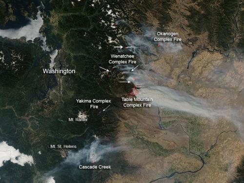
A couple large wildfires in the state of Washington have been burning for the past week or so and continue to grow in size. The fires, located in the central and southwestern part of Washington, were sparked by dry lightning a few weeks ago but have only started significantly growing in size this week. The main reason as to why these fires have now become large and uncontrolled can be attributed to the very dry conditions and warm temperatures on the west coast this past month.

Washington wildfires

Picture of various wildfires across Central Washington. (Source: NASA)

Currently, the largest fire in the state is the Wenatchee Fire Complex which covers around 16,000 hectares, is around 25% contained, and is being battled by over 2,000 firefighters. The second complex of fires, Table Mountain Complex, poses the highest level of threat to residents – causing 1,250 residents to evacuate and currently putting 750 homes at risk. Approximately 700 firefighters were currently at work on that specific fire complex which was only 5% contained as of Thursday. Smoke that has been slowly wafting further away from the fires, has started to affect surrounding communities in Central Washington thereby prompting the issuance of air quality advisories.

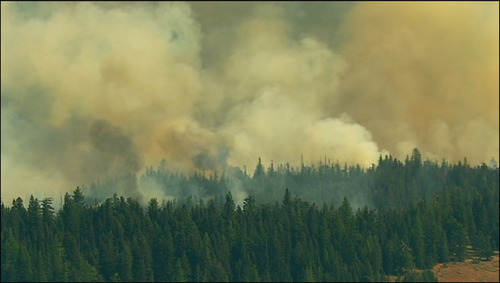
Wildfire

One of the numerous wildfires raging across Central Washington. (Source: KIMATV)

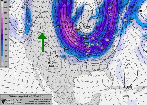
The reason for the unseasonably warm temperatures in Washington and the rest of the west coast this week (approximately 6°C above average) can be linked to a strong ridge of high pressure that has been in place since the start of this week. It appears that the balmy temperatures will stay put through the weekend. Early next week, a weak upper-level disturbance is predicted to slide through the area which could bring some precipitation with it to alleviate the threat of the fires, although it could also cause more trouble than good if more lightning strikes come with the system.

Ridge

Ridge over the west coast (indicated with green arrow) with 500mb winds and heights. (Source: Twisterdata)

An Unsettled Sunday, Otherwise Pleasant

Fairly pleasant weather will be on tap for next couple days until an upper trough swings through the area on Sunday, bringing a risk of showers or thunderstorms to the Red River Valley.

Pleasant Weather Ahead

Pleasant weather is on tap for Winnipeg.

Through the next couple days, mainly sunny skies and warm temperatures will be the dominant weather across the Red River Valley. High temperatures today and tomorrow will climb up to around 29°C, while sunny skies dominate today and we move into more of a mix of sun and cloud tomorrow.

On Sunday, an upper trough begins to work it’s way into Southern Manitoba. It’s very difficult to say what exactly is going to happen with this system as it moves through. It seems clear that there will be two main areas of precipitation:

  1. An area of rain that moves through the Interlake.
  2. An area of showers and/or thunderstorms that develops over North Dakota and slides southeastwards.

As for what happens over the Red River Valley; it’s tough to say. Guidance currently suggests that there’s a moderate chance of rain for us. Should we see precipitation, it’s likely that we’d see a batch of morning showers then a little bit of sunshine before some afternoon convection bubbles up over the Red River Valley. There would be a risk of non-severe thunderstorms if that scenario happens. This system seems to be quite sensitive, so we’ll be sure to post updates in the comments below. The daytime high on Sunday will end up being somewhere between 24°C to 27°C depending on how much sun or rain we see.

Sunny skies return to start next week before another system brings a chance of rain mid-week.

Warm, Unsettled Weather Continues

Warm weather will continue to dominate Southern Manitoba as we climb into the high 20’s almost every day this week. We’ll continue to see active weather as multiple systems move through the province over the second half of this week.

500mb Wind Field Valid Friday Night

Forecast 500mb wind field with heights depicting powerful upper low entering Southern Manitoba on Friday evening.

July ended up being a very hot month for Winnipeg, with 14 days of the month with daytime highs over 30°C. The month ended with an average temperature (highs and lows both considered) just over 22°C, which is about 2.5°C above the normal average temperature of 19°C. July marked the 13th consecutive month that Winnipeg has seen above-normal temperatures.

July marked the 13th consecutive month that Winnipeg has seen above-normal temperatures.

We’ll see a chance of afternoon thunderstorms across most areas of Southern Manitoba as a weak disturbance rounds the cold trough left behind yesterday’s system that brought a thunderstorm threat to Southern Manitoba. Chances for thunderstorms will be significantly higher through SW MB northwards through the Parkland region while the Red River Valley will see just a chance of thundershowers in the evening as the upper feature passes by. Daytime highs will be near 28°C through the Red River Valley with an overnight low tonight near a comfortable 15°C.

We’ll see a reprieve on Thursday, with no precipitation expected and a high near 28°C again. A powerful upper low will begin pushing across the Western Prairies bringing rain and cooler temperatures tommorow and will be the main weather-maker on Friday for us. Showers and thunderstorms will push into Western Manitoba on Thursday night and slide eastwards across the province through the day on Friday. It’s likey that we’ll see little precipitation on Friday as most of it pushes through the Interlake, however there’s a good chance of showers overnight on the backside of this system. We’ll see a daytime high of 24°C on Friday and a considerably cooler high near 20°C on Saturday.

Conditions will rapidly rebound through the end of the weekend as sunny skies return and temperatures shoot back up to 30°C.