Summer Weather on the Way

After another stretch of below-normal temperatures, some truly summer-like weather is finally on the way.

Winnipeg will be under the influence of a ridge of high pressure that will keep us dry through the remainder of the week. A developing flow from the Gulf of Mexico looks poised to set up Southern Mantioba for a quick shift into summer-like weather for the end of the week.

Wednesday
15°C / 6°C
Mixed skies with a clearing trend.

Thursday
23°C / 12°C
Mainly sunny.

Friday
26°C / 14°C
Mainly sunny.

Today will bring mixed skies to Winnipeg and the Red River Valley as the system cloud associated with the low that moved through on Monday and Tuesday begins exiting the province. Cloud will likely persist through the afternoon as some fair weather cumulus develop as we warm up to our high near 15°C. Skies will clear tonight as the temperature drops. The temperature will drop to around 6°C tonight.

Tomorrow will bring mainly sunny skies, relatively light winds and a high temperature returning to a seasonal to slightly above seasonal 22 or 23°C. Things will be calm and mainly clear Thursday night with temperatures dropping to near 12°C.

Friday will mark the shift towards decidedly more summer-like weather. Under mainly sunny skies, warmer air pushing into the region will push our daytime high towards around 26°C. In addition to the warmer weather, we should also see the first days of the year that could potentially be considered “humid.” For a quick summary of the relationship between dew point and how humid it feels, and why relative humidity is a poor choice, check out the brief primer at the bottom of this post.

There’s uncertainty in exactly how humid it will get here in Southern Manitoba. Some weather models, such as the Canadian GDPS[1] are pushing dew point values as high as 20°C in the Red River Valley, but values that high are likely overdone thanks to the delayed start to the growing season due to the abnormally cold spring. It’s likely we see dew points climb into the mid-teens at least, though, so it’s fairly safe to expect that we’ll be seeing our first real shot of summer heading into the weekend.

Unsettled Weekend

There’s still a lot of uncertainty associated with the large amplitude upper-level pattern that’s expected to develop this weekend, so in general vagueries…
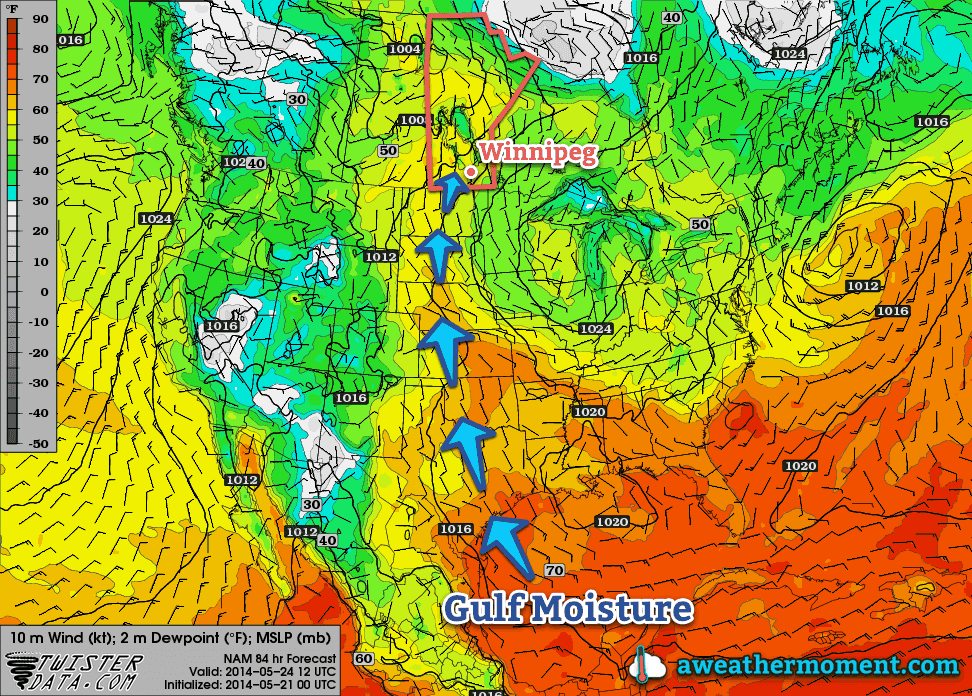
As the NAM shows, a broad flow from the Gulf of Mexico all the way to Southern Manitoba will be established by Saturday morning.

It’s going to be quite warm on Saturday. Daytime highs in the upper 20’s seem quite likely as well as dew points climbing into the mid-to-upper teens, although as mentioned above, there’s some uncertainty to exactly how high the dew points will get. Sunday will also be warm with highs in the mid-20’s.

Thunderstorms, potentially severe, will be possible both days, although exactly when and where is far too uncertain at the moment. It seems entirely possible that the thunderstorm activity will be constrained to the evening/overnight periods when elevated thunderstorms can develop, although late afternoon severe storms cannot be ruled out at this point. For both days the best chance for thunderstorms appears to be over Parkland Manitoba, SW Manitoba and into SE Saskatchewan and Montana/North Dakota. Here in the Red River Valley, nocturnal elevated activity looks like the most plausible scenario.

We’ll be taking a closer look at the thunderstorm and severe weather potential in Friday’s post. Until then, enjoy the imminent summer weather!


A Quick Lesson on Dew Points

Perhaps the most convenient way to quantify how humid it is outside is to look at the dew point temperature. The dew point is the temperature where water evaporates into the air at the same rate that it condenses out of the air; to put that in simpler terms, if the air comes in contact with something cooler than the dew point, water will condense out of it. Think of it as the temperature your cold glass of your favorite hot weather beverage needs to be to “sweat”.

The higher the dew point temperature is, the more water is in the air. This is an important distinction from relative humidity. Air has a quirky trait that allows it to hold more water the warmer it is. This means that air at -5°C cannot hold as much water as air at 25°C. This makes relative humidity ambiguous since it is a measure of how much water is in the air versus how much water the air can hold, or “how full the glass is.”

So a relative humdity of 100% at -5°C has less water in the air than a day where the temperature is 10°C with a relative humidity of 35% because the dew point in the first case is -5°C, while in the second case, despite the relative humidity of only 35%, the dew point is around -4.8°C.

As the dew point climbs, your perception of it being humid increases as well. In general, once the dew point rises to around 15 or 16°C, you’ll begin to notice that it feels humid. By 18 or 19°C it can begin to be uncomfortable. By the time the dew point climbs into the low-to-mid 20’s, as long as there’s sunshine, it can be extremely sticky feeling outside. Dew points in excess of 25°C are dangerous and can pose extreme health risks.


  1. Global Deterministic Prediction System  ↩

Moderating Trend Gives Way to Rainy Holiday

Temperatures will moderate to seasonal values by the end of the weekend, but the Victoria Day holiday may end up being quite wet.

Relief is in store for Southern Manitobans weary of the prolonged cold weather as milder air is finally set to return to the region. The intense upper-level cold trough over Ontario that has been bringing a strong northerly flow and cool weather to the region will finally begin to collapse, allowing milder air to work its way eastwards again. Temperatures will remain fairly mild while the weather takes a turn for the worse on Victoria Day as a low pressure system brings the potential for substantial rains across much of Southern Manitoba.

Friday
14°C / 0°C
Mainly sunny.

Saturday
18°C / 6°C
A few clouds.

Sunday
18°C / 8°C
Mixed skies.

Today and tomorrow will see daytime highs climbing towards the high teens with minimal in the way of cloud cover. Both days will also see light winds thanks to a ridge of high pressure situated over the province. We’ll likely see temperatures dip to the freezing mark tonight[1], but milder air will be in place for Saturday night making the overnight low around 5°C warmer.

Sunday will be a more unsettled day. Most places in Southern Manitoba will see cloudy periods with a very marginal chance of a shower. Winds will shift out of the south to 20-30km/h as a warm front lifts northwards through the day. Temperatures should climb to around 18°C and the temperature will drop to around 8°C on Sunday night.

Potentially Stormy Victoria Day Holiday

Monday
15°C / 10°C
Mainly cloudy; rain likely.

A powerful low pressure complex will develop over Saskatchewan on Monday which will bring wet weather to Southern Manitoba as a conveyor belt of warm, moist air sets up all the way from the Gulf of Mexico. We won’t see that warm, humid air at the surface, but thanks to a strong southerly flow aloft, strong isentropic ascent over the warm front will produce a very saturated, potentially unstable atmosphere over Southern Manitoba.

Rainfall forecast (in inches) from NOAA's WPC for Sunday evening through Tuesday evening. The WPC is forecasting as much as 25-30mm of rainfall for Southern Manitoba.
Rainfall forecast (in inches) from NOAA’s WPC for Sunday evening through Tuesday evening. The WPC is forecasting as much as 25-30mm of rainfall for Southern Manitoba.

What does this mean? We could see fairly heavy rainfall on Monday. There is still enough time for things to change substantially between now and then, but amounts anywhere from 5-25mm seem quite possible. The rainfall does seem quite convectively driven, and with a moderately strong 850mb jet there’s always the possibility the rainfall becomes attached to the left-exit region and ends up remaining to our south/southeast. We’ll be tracking this system through the weekend and have updates below when things begin to take shape.


  1. Hopefully for the last time until the fall.  ↩

Wet Week Leads to Gradual Improvement

A couple more days of unsettled weather will give way to some of the warmest temperatures of the year.

The main weather story will be gradual improvement as the week progresses. Currently we’re under the influence of a broad trough of low pressure that has brought scattered showers to the Red River Valley over the past couple days.

A complicated, high-amplitude flow is developing over the eastern Prairies.

Multiple bands of precipitation will be in place over Southern Manitoba today thanks to multiple disturbances and a fair amount of instability. As the upper-level flow finally organizes itself, a Colorado Low eject northeastwards on Thursday bringing potentially significant rainfall to the Red River Valley and Southeastern Manitoba. The unsettled weather will linger through Thursday night but then a weak ridge of high pressure will begin building in from the west, bringing more settled weather with relatively warm temperatures, especially compared to what we’ve been suffering through so far this spring.

Wednesday
12°C / 6°C
Mainly cloudy. Occasional showers likely.

Thursday
12°C / 4°C
Showers, possibly heavy at times. 5-15mm.

Friday
15°C / 5°C
Clearing.

Today

Today will bring mainly cloudy skies to the Red River Valley as a large low pressure complex stretching from Northern Saskatchewan to Colorado slowly begins organizing itself. More organized showers will fall through much of the day west of the Red River Valley through southwest regions and the Parkland with total accumulations around 5-10mm, but here in the valley we will likely only see scraps of elevated convective showers occasionally moving over the area.

I say likely since there is pretty high uncertainty in exactly how this system will evolve today. The band of showers to our west will slowly creep eastwards towards the RRV through the day and likely push into the western Red River Valley this afternoon. There’s a chance that it will continue pushing eastwards, and if that’s the case then we might see some more organized precipitation later in the afternoon into the evening. There’s also a very outside chance that this whole thing bumps eastwards mid-morning and we’re the ones stuck under the showers for the day.

Complicating matters will be a secondary band of precipitation that will develop this afternoon and lift northwards out of North Dakota and Minnesota. It’s currently forecast to just clip SE Manitoba, but if the upper level trough tilts a bit more, which it has been doing more than the models have been forecasting for 2 days now, that band of rain could end up inside the Red River Valley.

As a third complicating factor, there seems to be fairly unstable mid-levels over most of Southern Manitoba, so even if the precipitation stays to our west and east, there will still be a chance for some light showers zipping across the valley.

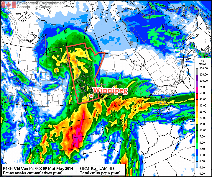
Total precipitation by Thursday evening from the RDPS. The question is will it even be close to right?

It’s a very complicated setup; most models agree that there will be rain on the western and eastern fringes of the Red River Valley with little in between[1], however slight variations in the actual positions of systems could change things quite dramatically. For that reason I’m say that there’s a good chance we’ll see occasional showers today. We may see more, we may see less, but this is a situation where trying to be any more specific than that will likely be a futile effort.

What is a little more certain is that we’ll see a high near 12°C today with light southeasterly winds.

The threat for showers will continue through the overnight period through most of the Red River Valley. We’ll drop to a low around 5 or 6°C with winds shifting around to the north.

Thursday

Thursday looks to be the most active day. A strong Colorado Low will track into Minnesota, spreading rain ahead of it into Southern Manitoba. Moderate instability aloft coupled with strong lift and enhanced convergence thanks to the deformation zone will result in showers, potentially fairly heavy at times, through much of Southern Manitoba. There may even be a very slight chance of a rumble of thunder or two.

The wet weather will likely last through much of the overnight period as well. By the end, anywhere from 5-15mm of rain seems likely over the Red River Valley; amounts will likely vary over short distances, and it’s impossible to say where will see the most rain until we’re closer to the event. I’d really love to be more specific, but with this rapidly developing, complex system, the models can be quite misleading and the best forecast will come from observing what’s actually happening and how things are developing in real time.

The high temperature on Thursday will be near 11-12°C once again, and the overnight low near 5°C.

Friday and Beyond

The weather finally looks to turn towards a more pleasant pattern for the end of the week. A cut-off cold low will spin aimlessly over the northwestern Prairies, leaving us on the warmer side of things as slightly milder air manages to work its way into the region. No substantial warm push is on the way, but with the cold air locked up well to our northwest, temperatures should manage to climb to around 15-16°C on Friday, Saturday and Sunday.

It seems quite likely that we’ll see our warmest day of the year this weekend. Currently, the warmest day we’ve had was a mere 15.1°C on April 23rd, but Saturday looks likely to beat that by a degree or so. Overnight lows are expected to sit near 5-6°C through Friday, Saturday and Sunday, which will be right around normal for this time of year.

Skies should be mainly sunny on Friday and Saturday, however we will likely see some cloud and a very slight chance of a shower on Sunday as a weak low pressure system pushes into western Manitoba.


  1. And I’m inclined to believe it given how often any sort of convective precipitation manages to end up on either side of Winnipeg.  ↩

Spring Storm Marks A Return to Form

A storm system pushing through Southern Manitoba tonight will bring snow, rain and everything in between to Southern Manitoba tonight, marking a significant shift in the upper-level flow that will bring seasonal to above seasonal temperatures through the weekend and into next week.

Friday
7°C / +2°C
Increasing cloud. Rain beginning this evening. 10-15mm.

Saturday
10°C / 0°C
Clearing in the afternoon; chance of showers.

Sunday
11°C / 0°C
Mainly sunny. Chance of showers overnight.

First Significant Rain of the Year

Today will be a pleasant day; high temperatures will sit around 6 or 7°C this afternoon with mainly sunny skies giving way to increasing cloudiness this evening. Winds will begin to pick up this afternoon to around 30km/h. The big story, though, is the low pressure system that will track through tonight.

A major low pressure system will begin pushing into Southern Manitoba tonight. This system, marking the transition into a warmer weather pattern, will spread significant rain and snow through the province during the overnight hours. Things will start off in the afternoon through the Parkland region with snow spreading eastwards from Saskatchewan. As the system pushes towards the Interlake and Red River Valley, precipitation will extend southwards, primarily as rain and then push eastwards through the remainder of the night. Winds will also be fairly strong, with sustained winds around 30-40km/h and gusts up to 60km/h.

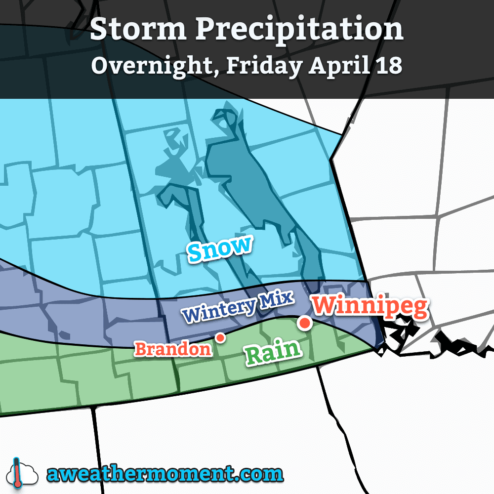
Multiple precipitation types will be coming into play again with this system. The primary rain-snow line, at this point, looks like it will sit 50-100km north of the Trans-Canada highway. This line is not set in stone, however, and will likely meander north and south as temperature profiles change and precipitation intensifies and subsides. Areas near the rain-snow line may see precipitation flip from one to the other multiple times. With this low pressure system freezing rain is not expected, but ice pellets or a rain/snow mix are entirely possible.

Expected precipitation types for tonight's storm system.
Expected precipitation types for tonight’s storm system.

Precipitation, while relatively short-lived, will be fairly intense with this system. The heaviest axis of precipitation looks to extend from Parkland Manitoba, through the southern Interlake and northern Red River Valley and then through SE Manitoba into NW Ontario. For those on the snow side of the rain/snow line in Parkland Manitoba (including Dauphin), snowfall amounts will peak at around 10-20cm with amounts tapering off towards the northern Interlake and the rain/snow line. For the areas that will see rain, amounts will be split into three main groups:

Location Rainfall Amount
Extreme SW Manitoba (Melita) <= 5mm
SW Manitoba & Southern RRV 5-10mm
Winnipeg/Northern RRV & SE Manitoba 10-15mm

Saturday will start off mainly cloudy with mist and fog scattered through the Red River Valley. There will be a slight chance of showers, particularly through the northern half of the valley through Winnipeg and into the Southern Interlake. For any activity that does occur, however, amounts will be fairly minimal. Winds will be relatively light and skies will begin to clear for a sunnier afternoon. The temperature will top out around 10°C.

Saturday night will see temperatures dip to around 0°C with light winds. It’s likely that the substantial precipitation coupled with rapid snow melt and calm winds will produce fairly extensive fog through the Red River Valley. Fog is notoriously difficult to predict, so we’ll keep tabs on things into the evening hours and try to give as much heads up one way or another as to what to expect. Just be aware that for travel overnight Saturday into Sunday, fog may play into the picture.

Warmer Weather Arrives

We’ll start pushing into the significantly warmer weather on Sunday as another low pressure system approaches, bringing with it another pulse of warm air. Temperatures in Winnipeg will climb to around 11°C on Sunday with light winds under mainly sunny skies[1]. Temperatures on Sunday night will drop to around 0°C once again, but we do have an ever so slight chance of seeing some showers overnight as a disturbance tracks along the U.S. border.

Daytime highs should sit near to just above normal through much of next week, generally in the 10-15°C range. No threats for precipitation are expected until the second half of the week.


  1. If we end up with fog on Saturday night, we’ll see a cloudier Sunday morning, however skies should clear by late morning for a sunny afternoon.  ↩