Elsewhere in Weather News: August 23rd, 2014

More Wildfires out West

Wildfires continue to be the story out west as large areas of not only western Canada, but also the western United States are experiencing tinder dry conditions. As explained in last week’s EIWN, these conditions are due to the persistent ridging that took place in most of July and early August over the region. The ridge brought limited precipitation and warm, dry air to the western half of North America. The Drought Index reveals this well, showing a large chunk of the western US under severe to exceptional drought.
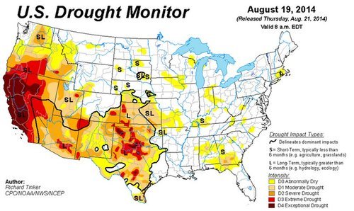
The Drought Index for this week continues to show significant drought in the west. (Source: USDM)

California which has seen no reprieve from the drought and saw another large wildfire flare up this week near Yosemite National Park. The fire, which started on August 18 just to the north of Oakhurst, quickly grew into a large wildfire that was out of control. Numerous air tankers, as well as 1,300 firefighters on the ground, are actively fighting the blaze. Yesterday the crews were able to gain more control of the fire, which was 95% contained as of Friday night. The wildfire is expected to be under full control by the end of this weekend. Some 500 structures in the path of the wildfire were at risk of getting torched on Tuesday and about 1,000 people had to evacuate from Oakhurst. As of Friday most homes had been saved though, with only 47 structures destroyed by the fire. The wildfire burnt an area totaling 612 acres, a small fire compared to the China Nose Fire discussed in last week’s EIWN which reached 9,100 acres in size this past week.
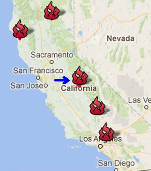
Map of current wildfires that are burning throughout California, Yosemite fire identified by the arrow. (Source: CAL Fire)

The next chance for rain in drought-stricken parts of California looks to be Tuesday as a trough digs into California and brings with it a chance of showers, however, there is signficant uncertainty regarding the strength of the trough.
Elsewhere in Weather News: August 16th, 2014

BC Wildfire Threatens Homes

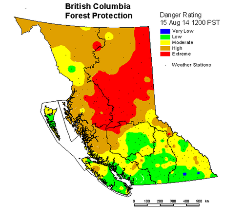
Numerous large wildfires have been burning throughout western Canada this month due to warm, dry weather in the west. Northern British Columbia and the Northwest Territories have been under the gun for most of July and August as ridging in the west has been persistent. The ridge resulted in warm and dry conditions with weak thunderstorms during the day that have been sparking the fires – not a good combination for fire prevention. As a result, a large portion of central and northern BC is now rated for extreme fire danger. A few significant fires are currently burning in northern BC including the Chelaslie Arm Wildfire and China Nose Wildfire.

BC fire danger rating as of Friday. (Source: BC Wildfire Management)

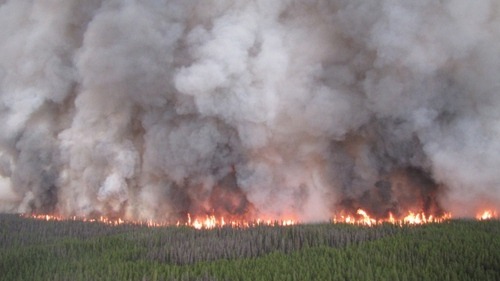
The China Nose Wildfire which is burning about 300km to the west northwest of Prince George is, as of this writing, zero percent contained and is threatening some 700 homes near China Lake and Houston, BC. As of Friday, estimates size the fire to be around 4,000 hectares – this is up from 1,200 hectares on Wednesday. A second large fire, the Chelaslie Arm Wildfire, is burning west-southwest of Prince George and is much larger than the China Nose Wildfire with an estimated size of 104,000 hectares. Entiako Provincial Park is most at risk from this fire – the park has closed and is under evacuation alert.

Chelaslie Arm Wildfire, seen from air. (Source: BC Wildfire Management)

Conditions are not superb for firefighting either fire this weekend either; westerly winds kicking in later this weekend will result in warm and dry conditions persisting. These fires can also result in poor air quality, not only for cities in the region but also cities downwind of the fires. Plumes of smoke from the fires in BC and the Northwest Territories can be seen traveling thousands of kilometres – as far as southern Ontario – when a northwest flow is in place.

Elsewhere in Weather News: May 17th, 2014

Wildfires Torch California, Helped by Strong Winds and Drought

This past week several wildfires have been burning out of control in San Diego County, just north of San Diego. It is not known whether any of the fires were started intentionally or not, however, the weather has played a significant role in hampering firefighting efforts. As of Friday evening there were four wildfires burning in the county which were all over 1,000 acres in size, and only one of these four was above 25% contained. There are two main points to note of as to why weather has played such a significant role in fueling the fires.

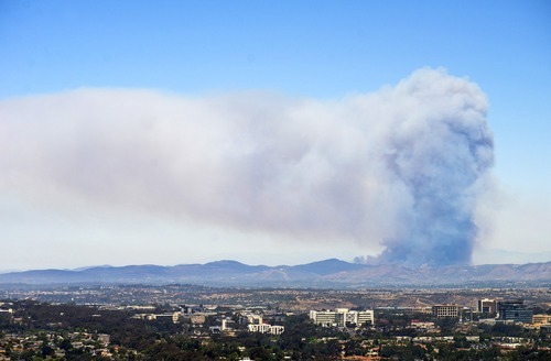
A large pyrocumulus cloud could be seen on Wednesday from San Diego looking towards the Cocos San Marcos fire. (Source: Mashable/Kent Horner)

The Santa Ana Winds are the first to have a big impact on wildfires currently burning out of control in Southern California. These winds occur when air blows towards the Pacific Ocean from the mountain ranges to the east. As the air descends the mountain sides it warms and its relative humidity decreases causing for hot and dry winds. This past week, relative humidity as low as 3% was observed by stations in southern California, coupled with winds of 50km/h, this produced prime wildfire conditions. The second reason as to why the wildfires have been difficult to contain is the current drought situation in the region. A large ridge of high pressure has been persistent over the west coast for most of this past winter and part of this spring, making precipitation difficult to come by. The drought index currently indicates that an extreme drought (second highest tier) is occurring in the region where the fires are burning. In turn, the wildfires have little trouble spreading to moisture-starved vegetation and dried out brush.

This weekend offers a mixed-bag to firefighters. Strong winds and scorching temperatures will persist during the day, but winds will now be out of the west causing for slightly moister air coming onshore from the Pacific. Regardless, the Storm Prediction Center maintains an “elevated” fire risk for this weekend.

Elsewhere in Weather News: October 19th, 2013

Australia Torched by Wildfires

This past week wildfires have been sweeping across New South Wales (NSW), a state located in the south-eastern part of Australia. A few thousand residents have been evacuated due to the fires, about 200 properties have been destroyed and one resident has died from the fires. West/northwest winds have been pushing plumes of smoke towards Sydney and dropping ash at the same time causing low visibilities at times and trouble for asthmatics. Currently, it’s not clear what started the fires. Some 60 fires were burning as of Thursday and about a third of them were not contained.

NSW fires

A few of the larger fires burning in NSW. Satellite image shows the plume of smoke over Sydney. (Source: NASA)

Unseasonably warm and dry weather is a factor as firefighters continue to battle the blaze in addition to dealing with gusty winds. A large high pressure sitting just off Australia’s east coast is to be blamed for bringing in the gusty northwest winds fuelling the fires. The next shot NSW will have at rain looks to be Tuesday as an area of low pressure passes to the south; the bulk of the rain will stay south but showers are still possible.

Yet Another Super Typhoon Forms

Francisco

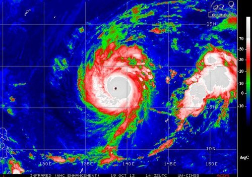
Super typhoon Francisco on Saturday morning. Note the well defined eye. (Source:CIMSS)

Super typhoon Francisco formed earlier this week and has already reached category five status as it churned over the very warm waters of the Northwest Pacific. This morning, a very well defined eye could be seen as Francisco started to move northwest, taking aim at Japan. It is expected to make landfall somewhere on the south-eastern coast of Japan, though there is some uncertainty as to where exactly since it still has four to five days to travel over ocean waters. Regardless of where it makes landfall it will pose a flooding threat to all of Japan’s four main islands. Thankfully, by the time Francisco reaches Japan it will have weakened as lower sea surface temperatures will make it tough for Francisco to sustain itself. The typhoon will likely be of category one or two as it makes landfall next week.