An Arctic Blast

This week will feature the coldest weather so far this winter, which is probably about all you need to know.

850mb temperatures on Monday morning

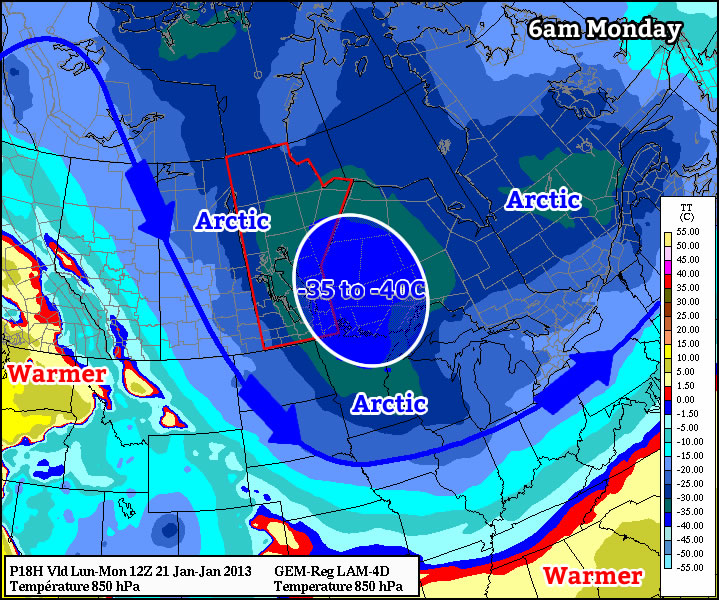
As we come off Monday morning’s very cold low temperatures, daytime highs won’t be able to get very warm, with values in the mid minus twenties expected. When you factor in the wind chill it will feel more like the low minus forties on Monday morning and the mid minus thirties on Monday afternoon. As we move into Monday night temperatures are expected to plummet once again. Models have had significant difficulties figuring out what will happen by Tuesday morning. Models have shown lows as cold as -47C on Tuesday morning (obviously an erroneous value), or as warm as -28C. It seems probable that we’ll end up somewhere between those two extremes, with lows in the mid minus thirties most likely. It shouldn’t be very windy at all on Tuesday morning, so at least we won’t have a big wind chill to contend with as well. It looks like we’ll “warm” up a bit on Tuesday, with daytime highs in the low minus twenties expected.

We shouldn’t see extreme overnight lows again on Wednesday morning since a weak passing weather system will prevent temperatures from bottoming out. However, another arctic front is forecast to pass through Southern Manitoba during the day on Wednesday, setting up more very cold weather for late week.

Unfortunately, there are no indications to suggest that we’ll see a warm-up any time soon. That means we may be stuck with cold to very cold weather for the rest of January.

Weather Roller Coaster

This week will be a bit of a meteorological roller coaster as our temperatures climb up, then fall rapidly back down again.

GEM-Regional predicted rainfall total for Monday

GEM-Regional predicted rainfall total for Monday

Monday looks to be the warmest day of the week with above freezing temperature of 1 or 2C expected in Southern Manitoba. Some light rainfall is expected in south-eastern parts of the province out ahead of a cold front. This may lead to icy conditions on Monday night as temperatures drop below zero behind the front. Winnipeg will be right on the edge of this area of rain, so the city isn’t expected to see more than a millimetre or two of rain at most. In fact most models take the area of rain just south-east of Winnipeg, so the northern part of the Red River Valley may end up with no precipitation at all. Temperatures will plummet on Monday night in the wake of the cold front with values dipping down into the minus double digits by Tuesday morning.

High temperatures will remain down in the minus teens in Southern Manitoba on Wednesday, with most areas in the -11 to -14C range. A weather system emerging from the mountains in Alberta will develop a southerly flow over Manitoba on Tuesday night. As a result, Tuesday night will be characterized by increasing warm air advection, allowing for warmer air to filter into Southern Manitoba during the overnight period. We will continue to experience warming on Wednesday as a stiff south wind continues to bring in warmer air. Unfortunately, the wind will be very strong, making conditions much less comfortable than the temperature alone would indicate. Highs on Wednesday will be in the low to mid minus single digits in Southern Manitoba, but wind chills values will be in the -10 to -15 range due to the strong south wind.

Another cold front will move through on Wednesday night or Thursday, setting up a chilly end to the week. No significant precipitation is currently in the forecast for Southern Manitoba this week as the main storm track remains to our north and west.

Continued Cold This Week

Cold air will remain entrenched over Southern Manitoba for the remainder of this week, until a large scale pattern shift once again brings warmer than normal temperatures to our area.

January 18, 1800Z (Noon) MSLP & Snow Accumulation Prog

January 18, 1800Z (Noon) MSLP & Snow Accumulation Prognosis

Snow will taper off by early afternoon today as an arctic high pressure system builds into Southern Manitoba as it pushes across Southern Alberta and Saskatchewan. Much of Southern Manitoba will see a total of around 2cm of snow when all is said and done, with a few localities along the international border seeing 2-4cm.

The big story over the next couple days will be the ridge building across the Prairies. Southern Manitoba will see the coldest temperatures of the winter with daytime highs continuing to be well below normal.

The average daytime high for the 18th of January is -13°C. The average overnight low for the same day is -23°C. Winnipeg will experience temperatures close to 10°C colder than average over the next few days.

This high pressure system has brought bitterly cold temperatures to Alberta & Saskatchewan, with daytime highs of only -29°C in Calgary, -28°C in Edmonton and Saskatoon, and -27°C in Regina yesterday. This air mass will push into our region today, which will limit our daytime high to about -23°C and bring us our first overnight low below -30°C tonight.

January 19, 1500Z (9AM) Wind Chill Prognosis

January 19, 1500Z (9AM) Wind Chill Prognosis

Attached to this cold arctic air mass will be increasing northwest winds to 20km/h, which will produce bitter wind chill values below -40 overnight Wednesday and through much of Thursday morning. At those values, exposed skin can freeze in 5 to 10 minutes, so be sure to dress warm!

Why don’t wind chill values have a °C attached?

Wind Chill is a value calculated from a complex equation that takes the air temperature, the wind speed, and some empirically calculated values for heat transfer through skin into account. When the calculations are done, the units cancel out, and you’re left with a unit-less number. So while the equation was tweaked to produce numbers that resemble temperatures, they aren’t!

If the current forecast works out, it’s likely that we’ll see a large portion of the Prairies covered with wind chill warnings Thursday morning. Little changes for Friday, so there’s a good chance we’ll see another repeat of exceptionally cold daytime highs and bitter wind chills at night.

Current forecasts show a pretty substantial area of warm air pushing into the Southern Prairies on the weekend, bringing daytime highs up by 10 to 15°C. Combined with the CPC’s new forecast of above normal temperatures returning to Southern Manitoba, it doesn’t seem like this winter spell is long to stay.